EP2991006A1 - Method for providing local risk level information - Google Patents
Method for providing local risk level information Download PDFInfo
- Publication number
- EP2991006A1 EP2991006A1 EP14290256.8A EP14290256A EP2991006A1 EP 2991006 A1 EP2991006 A1 EP 2991006A1 EP 14290256 A EP14290256 A EP 14290256A EP 2991006 A1 EP2991006 A1 EP 2991006A1
- Authority
- EP
- European Patent Office
- Prior art keywords
- risk
- local risk
- local
- potentials
- user
- Prior art date
- Legal status (The legal status is an assumption and is not a legal conclusion. Google has not performed a legal analysis and makes no representation as to the accuracy of the status listed.)
- Withdrawn
Links
- 238000000034 method Methods 0.000 title claims abstract description 35
- 231100000817 safety factor Toxicity 0.000 claims description 100
- 238000004140 cleaning Methods 0.000 claims description 29
- 238000012423 maintenance Methods 0.000 claims description 4
- 230000006870 function Effects 0.000 description 27
- 230000003068 static effect Effects 0.000 description 13
- 230000007935 neutral effect Effects 0.000 description 11
- 238000013500 data storage Methods 0.000 description 8
- 241001622623 Coeliadinae Species 0.000 description 7
- 238000012545 processing Methods 0.000 description 7
- 238000010586 diagram Methods 0.000 description 6
- 230000008901 benefit Effects 0.000 description 5
- 230000007423 decrease Effects 0.000 description 4
- 206010061599 Lower limb fracture Diseases 0.000 description 2
- 241001417527 Pempheridae Species 0.000 description 2
- 208000027418 Wounds and injury Diseases 0.000 description 2
- 238000004364 calculation method Methods 0.000 description 2
- 230000008859 change Effects 0.000 description 2
- 239000003086 colorant Substances 0.000 description 2
- 230000006378 damage Effects 0.000 description 2
- 230000003247 decreasing effect Effects 0.000 description 2
- 230000001419 dependent effect Effects 0.000 description 2
- 208000014674 injury Diseases 0.000 description 2
- 230000003287 optical effect Effects 0.000 description 2
- 230000008569 process Effects 0.000 description 2
- 235000005156 Brassica carinata Nutrition 0.000 description 1
- 244000257790 Brassica carinata Species 0.000 description 1
- 238000013459 approach Methods 0.000 description 1
- 230000005540 biological transmission Effects 0.000 description 1
- 230000001413 cellular effect Effects 0.000 description 1
- 238000004590 computer program Methods 0.000 description 1
- 230000000694 effects Effects 0.000 description 1
- 230000003203 everyday effect Effects 0.000 description 1
- 239000000383 hazardous chemical Substances 0.000 description 1
- 230000007246 mechanism Effects 0.000 description 1
- 230000003340 mental effect Effects 0.000 description 1
- 230000000630 rising effect Effects 0.000 description 1
- 239000007787 solid Substances 0.000 description 1
- 230000001960 triggered effect Effects 0.000 description 1
- XLYOFNOQVPJJNP-UHFFFAOYSA-N water Substances O XLYOFNOQVPJJNP-UHFFFAOYSA-N 0.000 description 1
Images


Classifications
-
- G06Q50/40—
-
- H—ELECTRICITY
- H04—ELECTRIC COMMUNICATION TECHNIQUE
- H04W—WIRELESS COMMUNICATION NETWORKS
- H04W4/00—Services specially adapted for wireless communication networks; Facilities therefor
- H04W4/02—Services making use of location information
- H04W4/029—Location-based management or tracking services
-
- G—PHYSICS
- G01—MEASURING; TESTING
- G01C—MEASURING DISTANCES, LEVELS OR BEARINGS; SURVEYING; NAVIGATION; GYROSCOPIC INSTRUMENTS; PHOTOGRAMMETRY OR VIDEOGRAMMETRY
- G01C21/00—Navigation; Navigational instruments not provided for in groups G01C1/00 - G01C19/00
- G01C21/26—Navigation; Navigational instruments not provided for in groups G01C1/00 - G01C19/00 specially adapted for navigation in a road network
- G01C21/34—Route searching; Route guidance
- G01C21/36—Input/output arrangements for on-board computers
- G01C21/3697—Output of additional, non-guidance related information, e.g. low fuel level
-
- G—PHYSICS
- G06—COMPUTING; CALCULATING OR COUNTING
- G06F—ELECTRIC DIGITAL DATA PROCESSING
- G06F16/00—Information retrieval; Database structures therefor; File system structures therefor
- G06F16/20—Information retrieval; Database structures therefor; File system structures therefor of structured data, e.g. relational data
- G06F16/29—Geographical information databases
-
- G—PHYSICS
- G06—COMPUTING; CALCULATING OR COUNTING
- G06F—ELECTRIC DIGITAL DATA PROCESSING
- G06F16/00—Information retrieval; Database structures therefor; File system structures therefor
- G06F16/90—Details of database functions independent of the retrieved data types
- G06F16/95—Retrieval from the web
- G06F16/953—Querying, e.g. by the use of web search engines
- G06F16/9537—Spatial or temporal dependent retrieval, e.g. spatiotemporal queries
-
- G—PHYSICS
- G06—COMPUTING; CALCULATING OR COUNTING
- G06Q—INFORMATION AND COMMUNICATION TECHNOLOGY [ICT] SPECIALLY ADAPTED FOR ADMINISTRATIVE, COMMERCIAL, FINANCIAL, MANAGERIAL OR SUPERVISORY PURPOSES; SYSTEMS OR METHODS SPECIALLY ADAPTED FOR ADMINISTRATIVE, COMMERCIAL, FINANCIAL, MANAGERIAL OR SUPERVISORY PURPOSES, NOT OTHERWISE PROVIDED FOR
- G06Q10/00—Administration; Management
- G06Q10/06—Resources, workflows, human or project management; Enterprise or organisation planning; Enterprise or organisation modelling
- G06Q10/063—Operations research, analysis or management
- G06Q10/0635—Risk analysis of enterprise or organisation activities
-
- G—PHYSICS
- G06—COMPUTING; CALCULATING OR COUNTING
- G06Q—INFORMATION AND COMMUNICATION TECHNOLOGY [ICT] SPECIALLY ADAPTED FOR ADMINISTRATIVE, COMMERCIAL, FINANCIAL, MANAGERIAL OR SUPERVISORY PURPOSES; SYSTEMS OR METHODS SPECIALLY ADAPTED FOR ADMINISTRATIVE, COMMERCIAL, FINANCIAL, MANAGERIAL OR SUPERVISORY PURPOSES, NOT OTHERWISE PROVIDED FOR
- G06Q10/00—Administration; Management
- G06Q10/06—Resources, workflows, human or project management; Enterprise or organisation planning; Enterprise or organisation modelling
- G06Q10/067—Enterprise or organisation modelling
-
- H—ELECTRICITY
- H04—ELECTRIC COMMUNICATION TECHNIQUE
- H04W—WIRELESS COMMUNICATION NETWORKS
- H04W4/00—Services specially adapted for wireless communication networks; Facilities therefor
- H04W4/02—Services making use of location information
Definitions
- the invention relates to the field of providing information about dangerous and safe locations, in particular of providing local risk level information for a user by means of a mobile device in connection with a cloud-based database.
- security applications have been developed, which in case of an accident enable a security call to an emergency service by means of a mobile phone, which also indicates the local position of the person having an accident.
- these applications only react in case an accident has already happened.
- the objective of the invention is achieved by a method for providing local risk level information.
- the method comprises collecting by a cloud-based database data on one or more local risk potentials and calculating local risk levels based on the one or more local risk potentials.
- a mobile device comprising a control unit adapted to retrieve data on one or more local risk potentials and to calculate individual local risk levels based on the one or more local risk potentials.
- the objective of the invention is further achieved by a system used for providing local risk level information.
- the system is adapted to collect data on one or more local risk potentials and to calculate local risk levels based on the one or more local risk potentials.
- the objective of the invention is further achieved by a software product adapted to execute the method for providing local risk level information, when the software product is executed on a computer.
- the local risk levels are calculated as individual local risk levels, wherein for calculating individual local risk levels additional steps are implemented in comparison to calculating local risk levels.
- One or more of the steps for implementing individual local risk levels which are implemented in addition to the steps of calculating local risk levels might be implemented before or after the steps which are implemented for calculating local risk levels.
- what is described herein with respect to local risk levels applies analogously for the individual local risk levels (and vice versa) with the exception that for calculating individual local risk levels individual risk parameters are taken into account (what is not done for calculating local risk levels).
- individual local risk levels are calculated from the local risk potentials and individual risk parameters of a user.
- an individual risk level map is generated from the calculated individual local risk levels.
- the individual risk level map shows a landscape of individual local risk levels.
- a mobile device provides pictures on a display of the mobile device indicating personal local risk levels calculated from the individual local risk levels and a determined geographical location of the user.
- a mobile device provides acoustic signals generated by the mobile device indicating personal local risk levels calculated from the individual local risk levels and a determined geographical location of the user.
- a mobile device provides pictures and acoustic signals indicating personal local risk levels calculated from the individual local risk levels and a determined geographical location of the user.
- the personal local risk levels are calculated by the mobile device.
- the personal local risk levels are calculated by a cloud-based server.
- the geographical location of a user is determined by the mobile device and transmitted from the mobile device to the cloud-based server.
- cloud-based is preferably understood in that the cloud-based database and the cloud-based server are implemented by resources, e.g. data storage and data processing resources, respectively, of one or more computers which are usually physically distributed and grouped together as virtual resources.
- resources e.g. data storage and data processing resources, respectively, of one or more computers which are usually physically distributed and grouped together as virtual resources.
- the feature "cloud-based” in the context of the cloud-based database is preferably understood in that the cloud-based database is implemented by resources, e.g. data storage resources, of one or more computers which are usually physically distributed and grouped together as virtual resources.
- the cloud-based database is a database which is implemented by resources, e.g. data storage resources, of one or more computers which are usually physically distributed and grouped together as virtual resources.
- the feature "cloud-based" in the context of the cloud-based server is preferably understood in that the cloud-based server is implemented by resources, e.g. data processing resources, of one or more computers which are usually physically distributed and grouped together as virtual resources.
- the cloud-based server is a server which is implemented by resources, e.g. data processing resources, of one or more computers which are usually physically distributed and grouped together as virtual resources.
- the cloud-based server determines the geographical location of the user by means of the mobile device.
- the one or more local risk potentials comprise risk factors. In a preferred embodiment, the one or more local risk potentials comprise safety factors. The risk factors could be also termed negative risk potentials and the safety factors could be also termed positive risk potentials.
- a risk factor indicates a danger, in particular at a specific location.
- a safety factor indicates a safety, in particular an enhanced safety (enhanced over a neutral level), in particular at a specific location.
- the one or more risk factors are based on data of one or more of the group of: weather conditions, crime statistics, any further statistics (e.g. traffic), experiences shared in community systems, road conditions, accident rates, wherein the one or more risk factors are based on previous, present and/or expected conditions.
- the one or more safety factors are based on data of one or more of the group of: a presence of police, of a street cleaning unit, of a maintenance entity, wherein the one or more safety factors are based on previous, present and/or expected conditions.
- Previous conditions are data, which might be called historical data, because they already happened in the past. Expected conditions might be based on forecasts (e.g. weather).
- a safety factor is a factor which reduces and/or eliminates a danger caused by a risk factor.
- collecting data on one or more local risk potentials comprises:
- a safety factor is a factor which reduces and/or eliminates a specific danger caused by a corresponding risk factor.
- collecting data on one or more local risk potentials comprises:
- calculating local risk levels based on the one or more local risk potentials comprises summing up the local risk potentials of a particular location of one or more locations to a respective local risk level of said location.
- calculating local risk levels based on the one or more local risk potentials comprises summing up the local risk potentials for each location of a plurality of locations to a respective local risk level of said location.
- the respective local risk level is the sum of the local risk potentials of a particular location.
- the local risk level of a particular location is the sum of the one or more local risk potentials of said location.
- calculating local risk levels based on the one or more local risk potentials comprises: for each location of a plurality of locations, summing up the one or more local risk potentials of said location to a respective local risk level.
- calculating local risk levels based on the one or more local risk potentials comprises: summing up the local risk potentials assigned to a particular location of a plurality of locations to respective local risk levels for the respective location of the plurality of locations.
- the one or more local risk potentials comprise static local risk potentials.
- one or more of the local risk potentials are dynamically changing and the local risk levels are re-calculated based on the one or more dynamically changing local risk potentials.
- the one or more dynamically changing local risk potentials comprise moving local risk potentials.
- the one or more local risk potentials comprise static local risk potentials.
- the one or more local risk potentials comprise temporarily varying local risk potentials.
- the one or more local risk potentials are weighted by predetermined values.
- the one or more local risk potentials are weighted by predetermined values and/or according to a predetermined spatial weighting function, in particular an exponential function.
- the spatial distribution of one or more local risk potentials are given by a predetermined function, in particular an exponential function or sum of exponential functions.
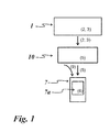
- Figure 1 depicts an overview of a method for providing local risk level information.
- data on one or more local risk potentials 2, 3 are collected.
- the data on one or more local risk potentials 2, 3 are collected by a database 1, which is in particular a cloud-based database 1.
- Figure 1 depicts database 1 which collects data on one more local risk potentials 2, 3.
- the local risk potentials 2, 3 comprise data which indicate a danger (negative local risk potential 2) and data which indicate a security (positive local risk potential 3).
- the data which indicate a danger are termed risk factors 2.
- the data which indicate a security are termed safety factors 3.
- a risk factor 2 is a local risk potential
- a safety factor 3 is a local risk potential, of course another local risk potential than the risk factor 2.
- a local risk potential 2, 3 is either a risk factor 2 or a safety factor 3.
- the database 1 collects data about local risk potentials 2, 3 which are input by (a) user(s)s into one or more computer of the user(s) connected wirelessly or by wire with the database, e.g. one or more users at the respective user's homes or in an internet café.
- the database 1 is gathering data on one or more local risk potentials 2, 3 via search machines, e.g. computer programs searching for information implemented via computers connected (wirelessly or by wire) with the database 1, in the Internet.
- the database 1 might in particular, search social networks for information about local risk potentials 2, 3.
- the database 1 might search news or information websites in the Internet for information about local risk potentials 2, 3.
- the database 1 might derive information from official databases (like e.g. official crime statistics from police).
- the database 1 might implement the search for information about local risk potentials 2, 3 automatically, regularly, or in the occasion of an event, e.g. triggered by a user or a manager of the database 1 for implementing a search for information about local risk potentials 2, 3.
- the database 1 is fed manually with data about local risk potentials 2, 3 by one or more users or further persons, in particular users/ further persons who become aware of local risk potentials 2, 3 (e.g. by walking through the streets - and becoming aware of e.g. a slippery stair (risk factor 2) and/or of a cleaning person cleaning the stair (safety factor 3) - or listening to news in TV or radio) and put the information on local risk potentials 2, 3 into the database 1, in particular via a smartphone (or any mobile device) of the one or more users or via a further computer.
- a slippery stair risk factor 2
- safety factor 3 cleaning person cleaning the stair
- the smartphone and/or the further computer might be connected wirelessly or by wire, via typical WAN, LAN, cellular and/or other networks which provide the communications connection to the database 1.
- the smartphone might be connected wirelessly or by wire to the computer and the computer might be connected wirelessly or by wire to the database 1.
- the database 1 provides information on the one or more local risk potentials 2, 3 to a server 10, which is in particular a cloud-based server 10.
- the server 10 generates individual local risk levels 5 out of the one or more local risk potentials 2, 3 and individual risk parameters of a user, namely the user of the mobile device 7, e.g. a smart phone, which is also depicted in figure 1 .
- the individual risk parameters of the user have been also stored in the database 1.
- the server 10 retrieves the individual risk parameters of the user from the database 1.
- the server 10 transmits the data about the individual local risk levels 5 to the mobile device 7 which generates personal local risk levels 8 of the user of the mobile device 7 based on the individual local risk levels 5 of the user and a determined geographical location 9 of the user of the mobile phone 7 (as will be described in detail below). Furthermore, the mobile device 7 generates a map showing the personal local risk levels 8 of the user of the mobile device 7. The map is presented on the display 7a of the mobile device 7 of the user.
- the individual risk parameters of the user are stored in the mobile device 7 of the user.
- the mobile device 1 retrieves information about local risk potentials 2, 3 from the database 1 and calculates individual local risk levels 5 from the local risk potentials 2, 3 and individual risk parameters of the user.
- the individual risk parameters of the user are kept into the mobile device 7 of the user and are not transmitted to the database 1 which provides the advantage that user does not need to provide his individual risk parameters to the database so that the data protection of the individual risk parameters of the user might be at least enhanced.
- the individual risk parameters of the user, stored in the mobile device 7 or in the database 1 might be protected against un-authorized access by data protection such as encryption, password etc.
- a risk factor 2 is for example represented by a stair (or staircase), which is not clean, because there is ice on the stair and thus, there is a danger of falling when walking over the stair.
- a safety factor 3 is for example a person cleaning the stair by taking away the ice off the stair and thus eliminating or at least reducing the danger of falling when walking over the stair.
- a danger which is caused by a risk factor 2 is reduced by a (corresponding) safety factor 3, if there is any present.
- a person cleaning a stair by taking away the ice is the safety factor 3 which reduces the danger caused by the risk factor 2 which is caused by the iced stair.
- a safety factor 3 can reduce a risk factor 2 only, if the safety factor 3 is specific for the risk factor 2, this means if the safety factor 3 is corresponding to the risk factor 2.
- the risk factor 2 caused by the danger of a bank robbery can not be reduced by the safety factor 3 of a cleaning person, this is a cleaning person is not the specific (corresponding) safety factor 3 to a risk factor 2 caused by a danger of a bank robbery.
- the safety factor 3 of a policeman is not the specific (corresponding) safety factor 2 for a risk factor 3 of an iced staircase, because usually the danger of the iced staircase is not reduced by the presence of a policeman, unless the policeman would give warning signals about the iced staircase.
- a local risk potential namely a risk factor 2
- another local risk potential namely a safety factor 3 corresponding to the risk factor
- a local risk level 4 for this location.
- the person cleans the stair by taking off the ice, the danger caused by the iced stair is eliminated.
- the safety factor 3 cleaning person eliminates the risk factor 2 (iced stair).
- the local risk level 4 is zero, because the local risk level 4 at a location is the sum of the local risk potentials 2, 3 at said location.
- the location where there is the stair is also a place where often dangerous persons are spotted.
- the stair is a point where possibly dangerous people meet often, because the stair is located in a dark place.
- the dangerous people might be persons living on the street and occasionally rob a single person walking over the stair. Therefore, there is a risk factor 2 caused by the dangerous people at the stair.
- a risk factor 2 could be caused by a danger that bad things might happened, this danger could be an abstract danger or a concrete danger.
- a concrete danger in this case would be that dangerous people are actually at the location of the stair.
- An abstract danger in this case would be that dangerous people could be at the location of the stair, because dangerous people have been seen many times before at the location of the stair and therefore there is a certain possibility that there are dangerous people at the location of the stair.
- the danger caused by dangerous people who are actually or might be at the location of the stair is a risk factor 2 at the location of the stair.
- All risk factors 2 and safety factors 3 at a particular location are summed up to a local risk level 4 at said location.
- the risk factor 2 caused by the iced stair, the risk factor 2 caused by the danger of the dangerous people at the location of the stair and the safety factor 3 given by the person cleaning the stair are taken into account for calculating the local risk level 4 at this location.
- the local risk level 4 at the location of the stair is given by the risk factor 2 caused by the danger of the dangerous people at the location of the stair, because the risk factor 2 caused by the ice on the stair is eliminated by the person cleaning the stair and taking away the ice.
- local risk levels 4 are calculated based on the one or more local risk potentials 2, 3.
- the local risk levels 4 are calculated in a general way, this means a local risk level 4 has general signification which is valid for every person who might be walking at the location of the stair.
- the danger which is caused by the dangerous people is same for every person which intends walking at the location of the stair where dangerous people might be, because in this example it is assumed that the dangerous people might attack any person walking at said location, no matter if the person is young or old.
- the risk factor 2 which is given by the dangerous people results in a local risk level 4 having a general or common signification for anybody in regard of said location of the stair.
- the risk potentials 2, 3 have a signification which is not same for anybody, but which is different according to a particular person or user.
- the danger caused by an iced stair is a rather small danger for a young person
- the same iced stair results to a rather big danger for an old person, because an old person will more likely fall, when walking on an iced stair and in case of falling on the stair, the old person will more likely suffer of injuries caused by a fall than a young person.
- the local risk potentials 2, 3 are weighted by individual risk parameters of the user (person) taking advantage of using the method for providing local risk level information.
- the local risk potentials 2, 3 are personalized by data given from the user, which results in the calculation of individual local risk levels 5 (of the respective user).
- individual local risk levels 5 are calculated out of the local risk potentials 2, 3, and individual risk parameters of a user.
- An individual risk parameter of a user is for example the age of the user, the gender of the user, a personal handicap such as a physical or mental handicap. Further, an individual risk parameter of a user might be a personal capability such as, if the user is able to swim or not. For example, a river, in particular with rising water, might be a danger for a user, who is not able to swim, but a rather small danger for a user who is a good swimmer. Thus, in an example, a risk factor 2 which is caused by a river will result in an individual local risk level 5 which is low for a user who is a good swimmer and will result in an individual local risk level 5 which is high for a user who is a poor swimmer.
- the risk factor 2 caused by the iced stair will result in a low individual risk level 5, because in our example, we assume that the user who is walking over the stair is a young person.
- the individual risk parameter of the user is the young age of the user.
- the risk factor 2 of an iced stair will lead to a small individual local risk level 5 based on a calculation out of the risk factor 2 of the iced stair and the individual risk parameter of the young age of the user.
- the user might be an old person.
- the individual risk parameter of that user this means the old age, will result in combination with the risk factor 2 of the iced stair in a high individual local risk level 5.
- the user is a person who is allowed to carry a weapon with himself, for example the user is a security person who has the right to carry a revolver with himself and actually takes the revolver with him. Therefore, the risk factor 2 caused by the danger of dangerous people at the location of the stair will in combination of an individual risk parameter of the user having a weapon and being able to use it will result in a rather low individual local risk level 5 in the context of the dangerous people.
- the individual risk parameter which is given from the right of a person to carry a weapon might be caused correspondingly by the strength of a person.
- a person who is very strong might be able to defend himself.
- the ability of defending oneself, e.g. by karate or boxing might be an individual risk parameter because e.g. a boxer might be less in a danger situation when meeting potentially dangerous people than a weak person who can not defend himself.
- the presence of people who might help a person in a potentially dangerous situation might cause a positive risk potential 3, namely a safety factor 3.
- a safety factor 3 E.g., a bit amount of people who are able to protect a person in case of a dangerous attacker comes around present a safety factor 3, because the people, maybe just by the big number of people, might be able to chase an attacker away and even to scare a potential attacker and prevent him from any attack.
- the one or more local risk potentials 2, 3 at a location wherein the one or more local risk potentials 2, 3 are weighted by respective individual risk parameters of a user, are summed up to an individual local risk level 5 for said user at said location.
- the risk factor 2 of the iced stair results in principle (taken as such without considering the further local risk potentials 2, 3 at that location) in a high individual risk level 5 because of the individual risk parameter of the user being an old person.
- the risk factor 2 of the dangerous people results in a reduced individual risk level 5 of the user having a weapon and being able to defend himself.
- the user is an old man, however having a weapon, therefore to the old man an iced staircase is in principle a big danger, whereas the man although being old is able to defend himself against dangerous people by means of his weapon.
- the risk factor 2 of the iced staircase which is weighted by the individual risk parameter of the old age of the user.
- the weighted risk factor 2 of the iced staircase is reduced by the safety factor 3 of the person cleaning the stair.
- the risk factor 2 of the dangerous people is calculated in consideration of the individual risk parameter of the user having a weapon to defend himself.
- the individual local risk 5 level will correspond to the risk factor 2 caused by the dangerous people weighted by the individual risk parameter of the user carrying a weapon, because the risk factor 2 by the iced stair is eliminated by the safety factor 3 of the person cleaning the stair.
- the one or more local risk potentials 2, 3 comprise static local risk potentials 2, 3.
- one or more local risk potentials 2, 3 are always same, this means they do not vary.
- a risk factor 2 is always the same over the time and at a given location. For example, a highway where there is always much traffic, same every day and every night, will have a high risk factor 2 which is same all days and all nights. In this case, the risk factor 2 might be termed a static risk factor.
- one or more of the local risk potentials 2, 3 are static in regard of the location, but variable over time, i.e. temporarily varying local risk potentials 2, 3.
- the risk factor 2 caused by an iced stair is static at a location, namely at the stair, but varies over time.
- the danger caused by an iced stair is higher than the danger caused by an iced stair during the day.
- the same applies for a slippery stair where the danger may result from the wet slippery surface of the stair during the night hours, while during the day the sun will eliminate the wet and make the stair safe(r).
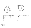
- Figure 2 depicts two examples of a locally static, but timely varying risk factor 2.
- the upper left picture shows a street corner which (based on information of the crime statistic) has a high risk factor 2 during the evening and night hours.
- the diagram depicts the risk factor 2 on the y-axis y over the time which is indicated by the x-axis x.
- the risk factor 2 is depicted as a negative value, which has a non-zero value during the night hours from 18:00 o'clock until 6:00 o'clock in the morning, and is close to zero from 6:00 o'clock in the morning until 18:00 o'clock in the evening.
- Figure 2 shows in the right upper picture a staircase which is known to be very slippery during the morning hours so the risk factor 2 rises by amount (or modulus) on the negative y-axis around 6 o'clock in the morning.
- the high risk factor 2 of the slippery stair during the morning hours might be known from information from street sweepers maintaining that staircase, or emergency and/or hospital statistics, or it may be provided by other people regularly using that staircase, etc.
- the street sweepers or further people walking around that location might have provided by their mobile phones or via input in an internet portal this information to the database 1.
- this information may be derived from data provided by sensors which are embedded into the surface of the staircase, or similar.
- the individual local risk level 5 at the location of the stair has been caused by the iced staircase and by the dangerous people at the location of the staircase.
- the stair has been cleaned by a cleaning person so that at 6 o'clock, the stair is supposed to be still clean.
- the local risk level 5 at the location of the stair is re-calculated based on the temporarily changing local risk potentials 2, 3.
- the risk factor 2 caused by the iced stair is eliminated by the safety factor 3 caused by the cleaning person, but the risk factor 2 caused by the dangerous people has increased.
- the individual local risk level 5 is re-calculated regularly or, if there is information about changing local risk potentials 2, 3 relevant for the individual local risk level 5 at a particular location.
- one or more of the local risk potentials 2, 3 are dynamically changing and the individual local risk levels 5 are re-calculated based on the one or more dynamically changing local risk potentials 2, 3.
- the one or more dynamically changing local risk potentials 2, 3 comprise moving local risk potentials 2, 3.
- the individual risk parameters might change dynamically.
- an individual risk parameter is the old age of a user. In this case, the older the user is, the more the individual risk parameter of the old age of the user is increased.
- Figure 3 depicts an example for the effect of a dynamically changing moving positive local risk potential, this means a safety factor 3, given by a police man arriving and staying at a particular location.
- the left upper picture of figure 3 shows a potentially dangerous street corner, which has in principle, as described in the context of figure 2 above, a high risk factor 2 during the night hours from 6 o'clock p.m. (18:00) until 6 o'clock a.m. (6.00).
- a police man comes around.
- the policeman is a moving safety factor 3, because around a policeman, e.g. within a circle of 500 meters around the policeman, the safety is enhanced. Therefore, as the policeman comes to the location of the potentially dangerous street corner, the policemen causes a safety factor 3 moving to the location.
- the local risk level 4 (and corresponding the individual local risk level 5 of a particular user, see above note) calculated by the risk factor 2 of the potentially dangerous street corner and the dynamically changing safety level 3 caused by the moving policemen has to be re-calculated.
- the lower picture on the left side shows the diagram of the local risk level 2 at the location of the street corner. Because of the safety factor 3 caused by the policemen coming to the street corner at 6 o'clock p.m. (18:00), but leaving the street corner again at 12 o'clock p.m. (24:00) the local risk level 4 has been risen to a quite neutral level (almost zero at the x-axis).
- the right picture in figure 3 shows a potentially slippery stair, which is not dangerous anymore from 4 o'clock in the morning, because of the cleaning person cleaning the stair at 4 o'clock in the morning.
- the cleaning person is a safety factor 3 which is dynamically changing, because the safety factor 3 only occurs, when the cleaning person comes and cleans the stair.
- the local risk level 4 at the location of the stair is re-calculated and results in that the local risk level 4 at the location of the stair is reduced to zero from 4 o'clock in the night until midnight.
- the stair becomes more and more slippery in the night after midnight resulting in the risk factor 2 of the stair to rise (negatively), until the cleaning person comes at 4 o'clock.
- the one or more local risk potentials 2, 3 are weighted by predetermined values.
- This implementation of weighting local risk potentials 2, 3 by predetermined values is similar to the embodiments of taking individual risk parameters into account. However, in contrast to the individual risk parameter which is dependent on a particular user, the predetermined values used in this embodiment for weighting a local risk potential 2, 3 is determined as a general applicable value. For example, a risk factor 2 which generally provides a big danger is weighted by a high value, while a risk factor 2 which generally provides a small danger is weighted by a low value.
- a risk factor 2 of a danger caused by the traffic on a highway is weighted with a high value, while the risk factor of a danger caused by the traffic on a railway is weighted with a low value, because generally driving on a highway is more dangerous than driving in a train.
- the step of explicitly implementing the step of weighting a local risk potential 2, 3 by a predetermined value is omitted, because the danger or the safety of the respective local risk potential 2, 3 is already expressed by the value of the respective local risk potential 2, 3.
- the weighting of a local risk potential 2, 3, by determining the amount of the risk or safety, respectively might be implemented in an explicit weighting step or implicitly, when determining the local risk potential 2, 3.
- the local risk potentials 2, 3 are scaled, in particular by numbers.
- the risk factors 2 have a negative scale, with zero denoting no risk up to a negative number (e.g. - 20) denoting a high risk.
- a negative number having a small modulus e.g. - 10
- a medium risk e.g., few dangerous people at a location
- a negative number having a high modulus e.g. - 20
- the safety factors 3 have a positive scale, with zero denoting a neutral safety value up to a positive number (e.g.
- a positive number having a small modulus denotes a medium safety (e.g., few policemen at a location)
- a positive number having a high modulus denotes a very high safety (e.g., many policemen at a location).
- risk potential (rp) Function of crime rate (by day, daytime, ... ; from statistics)
- risk potential (rp) Function of accident rate (by day, daytime, ... ; from statistics)
- risk potential (rp) data from historical statistics by location, day, daytime, etc.
- risk potential (rp) function of environmental hazards (e.g. weather, local factors (desert, ocean, jungle), etc.), and any
- one or more local risk potentials 2, 3 are weighted according to a predetermined spatial weighting function, in particular an exponential function.
- a local risk potential 2, 3 is determined as a relative risk potential 2, 3 as a function of the distance, wherein the amount of the local risk potential 2, 3 is determined by an exponential function which has its maximum amount in the centre of the location and is an exponential curve from the centre of the location to outwards of the location.
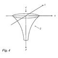
- Figure 4 depicts a risk factor 2 which is given as a relative risk potential as a function of the distance between origin of risk and user position, having an exponential shape from the centre c of a risk location to outwards of the location.
- the risk factor 2 is a negative risk potential and the risk factor 2 is depicted as a three dimensional function having a centre c of a location in the middle and going in each direction (to the left, to the right, to the front, to the back and in any direction from the centre to outwards) and therefore, the shown risk potential 2 is a three dimensional exponentially shaped function.
- risk parameters 2, 3 is a three dimensional function giving risk potentials 2, 3 at any point in a three dimensional space (length, width, height), in figure 4 for simplicity reasons, the risk potential distribution is depicted over a two dimensional area x, z and the level of the risk potential 2 (risk factor 2) is given on the y-axis. (Same applies for risk potential 3 (safety factor 3) in figure 5 below).
- the area which is spanned by the x-axis x and the z-axis z includes all locations in a certain spatial distance and direction from the centre and the y-axis y indicates the amount of the negative risk factor 2 which is high (by modulus) on the centre c (wherein the centre c is placed in the crossing of the x- and z-axis, where the x and z values are zero, this means no distance from the centre c) and is indicated by a high modulus on the y-axis y with a negative scale (i.e. going downwards).
- the risk factor 2 is getting smaller by modulus, this means is going upwards on the y-axis y.
- the risk factor 2 is zero which is indicated as the risk factor 2 is on the neutral level which is the most upper level or point on the y-axis y (in fig. 4 the most upper level or zero level of the y-axis is spanned by the x- and z-axis).
- the risk factor 2 is for example caused by a dangerous person, for example a criminal who is at a moment situated at a particular location, here in the centre c. Therefore, at this location, the risk factor 2 given by the dangerous person is high, this is the risk factor 2 has a high modulus and thus, because it is a negative local risk potential, has a high negative value.
- the farer away from the location of the dangerous person the less is the danger for somebody being attacked by the dangerous person, so that the modulus of the risk factor 2 is reduced with increasing distance from the location where the dangerous person is..
- the danger is reduced by the shape of an exponential function, until it reaches finally a neutral value.
- the local risk potential increases from a maximum negative value in the middle (centre c) to a zero value indicating a neutral zone, where there is no more danger caused by the dangerous person in the centre.
- the neutral zone will be reached for example at 100 meters away from the dangerous person (located in the centre c), or one kilometre depending the chosen values for the exponential function describing how far the danger of the dangerous person is reaching.
- a man having a pistol might have the same risk factor 2 in the centre of a location as a man having a gun, because at the centre the man with a pistol can kill someone in the same way as a man having a gun.
- a gun has a longer distance for shooting someone than the distance to shoot someone with a pistol. Therefore, the risk factor 2 given by a gun decreases less than the risk factor 2 given by a pistol. Therefore, in case of a gun the neutral zone might be reached only a 200 meters from the centre (location of the man having a gun), while in case of a pistol the neutral zone might be reached already at 50 meters from the centre (location of the man having a pistol).
- nRP rel Relative negative risk potential 2
- the risk factor 2 x 0 and z 0 the coordinates of the negative risk source (origin of negative risk, or coordinates of centre c)
- f x and f z Functions that weight the negative risk potentials 2 in the area determined by the x and z-axis respectively (e.g. as described in the context of the weighting factors).
- a safety factor 3 is depicted as a relative positive risk potential having a maximum safety value at the centre c indicated by the maximum modulus on the y-axis and decreasing in an exponential shape with the distance, i.e. with increasing x- and/or z-values, until the safety factor reaches the neutral zone or zero level, where the source of the safety factor 3 does not provide safety anymore.
- the source of the safety factor 3 might be a policeman and it is assumed that in a distance of 100 meters around the policeman the safety is enhanced with a maximum safety at the location where the policeman is located (in the centre c), decreasing exponentially with the distance from the policemen.
- pRP rel Relative positive risk potential 3, here the safety factor 3 x 0 and z 0 : the coordinates of the positive risk source (origin of positive risk, or coordinates of centre c)
- f x and f z Functions that weight particular (positive) risk potentials 3 in the area determined by the x and z-axis respectively (e.g. as described in the context of the weighting factors).
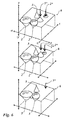
- an individual risk level map is generated out of the calculated individual local risk levels showing a landscape of individual local risk levels.
- Figure 6 depicts an example of a landscape in the form of an individual risk level map 6.
- the individual risk level map 6 is depicted in a three picture sequence from up to down, because one or more of the depicted risk level potentials 2, 3 and resulting individual local risk levels 5 are dynamic.
- a individual local risk level 5 is the sum of the local risk potentials 2, 3 at a particular location (and further considering the individual risk parameters of a user as described above).
- Figure 6 shows in a three pictures sequence (from top to down) a situation with 3 static negative local risk potentials 2, namely three static risk factors 2 of which one is indicated by 2*. Further there are two positive local risk potentials 3, namely one static safety factor 3 and one dynamic (moving) safety factor 3*.
- the moving safety factor 3* e.g. coming policemen
- the corresponding static risk factor 2* e.g. dangerous people at location
- the moving safety factor 3* approaches the static risk factor 2* (middle picture) and finally neutralizes it (lower picture) indicated by the resulting individual local risk level 5* which is zero or neutral.
- the individual local risk level 5 which is the sum of the local risk potentials at a particular location is zero, as far as there are no other local risk potentials 2, 3 at this location.
- the individual local risk level 5 corresponds to said negative or positive local risk potential 2, 3, respectively (see figure 6 , e.g. upper/middle and lower picture).
- the individual local risk level 5 is the sum of these two or more negative local risk potentials 2.
- the individual local risk level 5 is the sum of these two or more positive local risk potentials 3.
- the local risk potentials 2, 3 are calculated and/or depicted in an abstracted manner, e.g. scaled by numbers. Therefore, two or more different negative local risk potentials 2 are summed to a negative individual local risk level 5. Correspondingly, two or more different positive local risk potentials 3 are summed to a positive individual local risk level 5. In case, there are negative and positive local risk potentials 2, 3 at a location, which are not corresponding (e.g.
- a risk factor 2 given by a iced stair and a safety factor 3 given by a policeman who can not prevent from slipping over the iced stair preferably two or more (here two) individual local risk levels 5 are depicted at the location, one negative for the iced stair and one positive for the policeman).
- negative and positive local risk potentials 2, 3 might be summed up and thus reduce each other or even neutralized each other, even if the negative and positive local risk potentials 2, 3 are not corresponding, so that the risk factor 2 given by the iced stair is reduced or neutralized by the safety factor 3 given by the policeman at the location of the stair.
- the risk factor 2 given by the iced stair is reduced or neutralized by the safety factor 3 given by the policeman at the location of the stair.
- only corresponding negative and positive local risk potentials 2, 3 are reducing each other when being summed up.
- local risk potentials 2 can only be summed up, if the respective risk factor 2 and the respective safety factor 3, are corresponding to each other, which might be defined as the risk factor 2 and the safety factor 3 belong to the same risk type.
- a safety factor 3 and a risk factor 2 belong to the same risk type, if the safety factor 3 is actually (in real life) able to reduce the danger caused by a risk factor 2.
- a risk type might be ice on a staircase, so that the risk factor 2 is the danger caused by the iced staircase and the safety factor 3 is the safety provided by a cleaning person cleaning the staircase.
- one or more safety factors 3 might be summed up with one or more corresponding risk factors 2, if the safety factors 3 and the risk factors 2 belong to the same risk type.
- a risk factor 2 caused by dangerous people might be summed up and thus reduced by a corresponding safety factor 3 caused by a group of helping people who might be able to protect a person against the dangerous people and by a further corresponding safety factor 3 caused by a policeman coming around.
- the safety factor 3 caused by a policeman can not be summed up (and thus reduce or eliminate) the risk factor 2 caused by an iced staircase, because a policeman (safety factor 3) and an iced staircase (risk factor 2) do not belong to the same risk type, the presence of a policeman usually does not reduce the danger caused by an iced staircase, the policeman does not provide a safety factor 3 specific to the risk factor 2 of an iced staircase.
- a negative local risk potential 2 and a positive local risk potentials 3 are corresponding in particular, if the positive local risk potential 3 is actually (e.g. in reality) able to reduce the danger which is caused by the negative local risk potential 2.
- a person cleaning a stair is the corresponding safety factor 3 for the risk factor 2 caused by the iced stair.
- a policeman is the corresponding safety factor 3 for the risk factor 2 caused by dangerous people at a location.
- a policeman usually is not the corresponding safety factor 3 for the risk factor 2 of an iced stair, because usually a policeman does not clean the iced stair and usually might not give any warning of an iced stair to people walking around.
- a policeman might be the corresponding safety factor 3 for the risk factor 2 which is caused by a dangerous crossroad, if the policeman is supposed to eliminate the danger of the dangerous crossroad or at least give warning information for surrounding cars or people approaching the dangerous crossroad).
- the information about the one or more local risk potentials 2, 3 and/or the one or more local risk levels 4, in particular individual local risk levels 5, are presented by a mobile device 7 which might be termed personal safe guide.
- the mobile device 7 is preferably a smart phone.
- the mobile device 7 might also be a tablet computer, a personal digital assistant or a satnav terminal, i.e. a car navigation device, or a further mobile device appropriate to be used for implementing the method of providing local risk level information.
- the information on local risk potentials 2, 3 and/or local risk levels 4, in particular individual local risk levels 5, is provided for the user of the mobile device 7.
- the individual risk parameters used for calculating the individual local risk levels 5 are the individual risk parameters of the user of the mobile device 7.
- individual risk levels 5 of a person different from the user of the mobile device 7 are depicted by the mobile device 7 based on the individual risk parameters of said different person.
- the one or more individual local risk levels 5 are further processed into personal local risk levels 8 as will be described below. This is done in particular by a mobile device 7 of the user of which the personal local risk levels 8 are generated and provided, in particular by the mobile device 7 of the user.
- the mobile device 7 of the user provides pictures on a display indicating personal local risk levels 8.
- the mobile device 7 of the user provides acoustic signals indicating personal local risk levels 8.
- the personal local risk levels 8 is information which is further personalized in regard of the individual local risk levels 5 in that the personal local risk levels 8 are processed, in particular calculated or selected, out of the individual local risk levels 5 and a determined geographical location 9 of the user.
- the geographical location 9 of the user might be determined based on one or more signals that are emitted and received by the mobile device 7.
- the geographical location (or position) 9 of a mobile device 7 and thus of a user carrying the mobile device 7 is determined via GPS.
- any other location positioning system might be used for determining the geographical location 9 of the mobile device 7 and thus of the user carrying the mobile device 7. Based on the individual local risk levels 5 and the determined geographical location 9 of the user, personal local risk levels 8 are provided.
- the personal local risk levels 9 are a selection out of the individual local risk levels 5, wherein the selection out of the individual local risk levels 5 is determined by the geographical location 9 of the user.
- the geographical location 9 of the user might be used to select the individual local risk levels 5 which are of interest for the user because they are in the adjacency of the user.
- the user might input a desired goal or target place where the user wants to go, and the information about the geographical position 9 of the user in combination with the desired target are used to select the provided information of the individual local risk levels 5 as personal local risk levels 8 which are of interest for the user as they are nearby the way which the user has to go from its geographical position 9 to the target.
- the mobile device 7 indicates one or several proposals of ways from which the user should choose, because the proposed ways have no or small risk thus avoiding places or ways which are rather dangerous for the user.
- the mobile device 7 calculates individual local risk levels 5 based on the determined geographical location 9 of the user, this means the mobile device 7 calculates only those individual local risk levels 5 which are of interest based on the geographical location 9 of the user.
- the individual local risk levels 5 which are calculated in consideration of the geographical location 9 of the user are the personal local risk levels 8 of the user.
- the mobile device calculates individual local risk levels 5 of the user without considering the geographical location 9 of the user and then selects those individual local risk levels 5 of the user which are of interest based on the user's geographical location 9 and provides said selected individual local risk levels 5 as personal local risk levels 8.
- Figure 7 depicts an example of a particular map displayed by the mobile device 7.
- Figure 7 shows the geographical location 9 of the user and a proposed way from the geographical location 9 of the user to a target t.
- the proposed way avoids passing areas of personal local risk levels 8 which are indicated as dangerous as they are depicted as hatched circles 8(a).
- the personal local risk levels 8 which are depicted as plain (not-hatched) circles 8(b) indicate that there is no danger, but even a safety zone.
- a personal local risk level 8 which has a positive amount (safety) is depicted in a first colour, e.g. green
- a negative local risk level 8 which has a negative amount (danger) is depicted in a second colour, e.g. red.
- the amount of a personal local risk level 8 is indicated by the size of the circle.
- the modulus of the risk levels is big at the centre of a circle and decreases as an exponential function from the centre of a particular personal risk level circle 8 to outwards as described in regard of the local risk potentials 2, 3 what applies analogously for the personal local risk levels 8.
- Figure 8 shows other examples of display content showing personal local risk levels 8 and a geographical location 9 of a user.
- the three pictures might be what is displayed by the mobile 7 device once the geographical location 9 of the user has been determined and the user wants to know, if the user is at a safe or dangerous place.
- the user In the left picture, the user is on the one hand in a dangerous area, as indicated by the hatched circle 8(a).
- the dangerous zone 8(a) is overlapped by a safety zone 8(b), of which the safety eliminates the danger so that in the end the place where the user is located, is safe.
- the danger of the dangerous zone 8(a) exceeds the safety of the safety zone 8(b), so that the user at his geographical location 9 is not safe and might be invited to leave this area.
- the user is again in a dangerous zone 8(a) at the geographical location 9 and should leave this place.
- acoustic signals might be used to indicate safe and dangerous personal local risk levels 8.
- a nice tone or silence might indicate that the user's geographical location is in a safe personal local risk level 8
- an unpleasant tone indicates the user's geographical location is in a dangerous personal local risk level 8. If the user is on a way walking around, the tone might change from silence or a nice tone when passing a safe zone (safe or positive personal local risk level) to a unpleasant tone when passing a dangerous zone (dangerous or negative personal local risk level).
- Figure 9 depicts another example of what might be displayed by the mobile device 7.
- Figure 9 shows on the left and right picture the display 7a of the mobile device 7 and a boat I in the surrounding ocean O.
- the ocean is indicated as a dangerous area, indicated by the hatched presentation, while the boat I on the left picture is indicated as a safe place (not-hatched).
- the boat I hits an iceberg, so that the boat loses its positive safety potential (and is now hatched indicating to be a dangerous place) and the user of the mobile device 7 will be informed to better reach for the rescue boat II, which is indicated as being safe (not-hatched).
- Figure 10 depicts a schematic diagram of the system 11.
- Figure 10 shows a more general presentation of the system 11 than the block diagram in figure 1 .
- the system 11 comprises one or more of: a database 1, which is in particular a cloud-based database 1, a server 10, which is in particular a cloud-based server 10, and a mobile device 7.
- a database 1 which is in particular a cloud-based database 1
- a server 10 which is in particular a cloud-based server 10
- the system 11 comprises the (cloud-based) database 1 and the mobile device 7 and optionally the (cloud-based) server 10.
- the, preferably cloud-based, database 1, the, preferably cloud-based, server 10 and the mobile device 7 transmit data between each other.
- the geographical location 9 of the user is determined by the mobile device 7 and transmitted from the mobile device 7 to the cloud-based server 1.
- the mobile device 7, in particular via GPS determines its own geographical position, and sends the geographical position to the cloud-based server 10 or to a cloud-based database 1 from which the cloud-based server 10 receives the data.
- the cloud-based server 10 determines the geographical location 9 of the user by means of the mobile device 7.
- the cloud-based server 10 is able to determine the geographical location 9 of the mobile device 7 based on signals that the mobile device 7 causes in operation or even in idle mode (e.g. when sending or receiving tones or specific positioning signals).
- the cloud-based server 10 determines the geographical location 9 of the mobile device 7 and thus of the user carrying the mobile device 7 and calculates the personal local risk levels 8 as described above in detail.
- all steps described as being implemented by the cloud-based server 11 are implemented instead by the mobile device 7.
- personal local risk levels 8, local risk levels 4, individual local risk levels 5 and/or local risk potentials 2,3 are provided in the form of a map showing a landscape on which the personal local risk levels 8, local risk levels 4, individual local risk levels 5 and/or local risk potentials 2,3, are depicted, in each case preferably for a determined area, which is in case of the personal local risk levels 5 even more specified by the geographical location 9 of the user.
- the landscape is in particular displayed on the display 7a of the mobile device 7.
- the local risk levels 4, individual local risk levels 5 and/or local risk potentials 2, 3 are depicted in a landscape by e.g. one of the presentations as described throughout the description (e.g.
- the circles depicted in figure 7 might represent personal local risk levels 8, local risk levels 4, individual local risk levels 5 or local risk potentials 2, 3.
- the hatched circles might indicate a negative personal local risk level 8, a negative local risk level 4, a negative individual local risk level 5 or a negative local risk potential 2 (risk factor 2).
- the plain circles might indicate a positive personal local risk level 8, a positive local risk level 4, a positive individual local risk level 5 or a positive local risk potential 3 (safety factor 3).
- the personal local risk levels 8 of a user are calculated by the mobile device 7 of a user.
- the mobile device 7 receives data about local risk potentials 2, 3 from a cloud-based database 1 and implements the above described steps for calculating based on the data of local risk potentials 2, 3, of individual risk parameters and of the geographical location 9 of the user, the personal local risk levels 8 of the user.
- the individual local risk levels 5 are calculated by a cloud-based server 10.
- the cloud-based server 10 receives data about local risk potentials 2, 3 from a cloud-based database 1 and calculates the individual local risk levels 5 based on the local risk potentials 2, 3 and individual risk parameters of a user. Before, the cloud-based server 10 received also the individual risk parameters.
- the user transmits the individual risk parameters of the user to the cloud-based database 1 from which the cloud-based server 10 receives the individual risk parameters of the user. Alternatively, the user transmits the individual risk parameters of the user, e.g. by the mobile device 7 of the user, to the cloud-based server 10.
- the database 1 is in particular a cloud-based database 1 and the server 10 is in particular a cloud-based server 10.
- a server 10 is used which is not implemented within a cloud.
- a database 10 is used which is not implemented within a cloud.
- the personal local risk levels 5 are calculated by a cloud-based server 10.
- the cloud-based server 10 calculates in this preferred embodiment also the personal local risk levels 8 of the user based on the geographical location 9 of the user and the data about the local risk potentials 2, 3 and/or the individual local risk levels 5 as described above in detail.
- the cloud-based server 10 receives the data about the local risk potentials 2, 3, individual local risk levels 5, individual risk parameters and/or geographical location 9 of the user from a cloud-based database 1.
- the cloud-based server 10 might receive the data about the individual risk parameters and/or geographical location 9 of the user from the user's mobile device 7.
- data on local risk levels 4, individual local risk levels 5 and/or personal local risk levels 8, after being calculated by the mobile device 7 and/or the server 10 are transmitted to the database 1 for storage.
- the mobile device 1 and/or the server 10 might retrieve the data on local risk levels 4, individual local risk levels 5 and/or personal local risk levels 8 stored at the database 1 from the database 1.
- the mobile device 7 and/or the server 10 stores data on calculated local risk levels 4, individual local risk levels 5 and/or personal local risk levels 8 in an own storage.
- the implementation of processing, in particular calculating, storing and/or transmitting data as described in this paragraph might be provided in addition or alternative to the data processing, data storage and data transmission as described throughout the description.
- the data on the local risk potentials 2, 3 are stored at the database 1 as described above and retrieved by the server 10 and/or the mobile device 7 for further processing as described above.
- the invention is implemented in particular by means of a mobile device 7.
- the mobile device 7 comprises preferably a control unit and a data storage.
- the data storage is adapted to store data on local risk potentials 2, 3, individual risk parameters 4, local risk levels 4, individual local risk levels 5 and/or personal local risk levels 8.
- the mobile device 7 receives and/or processes, in particular calculates, one or more of the data as described throughout this description.
- the mobile device 7 receives data on local risk potentials 2, 3 from a cloud-based database 1.
- the mobile device 7 has already data on individual risk parameters of the user of the mobile device 7 because the user puts this information into the mobile device 7, in particular via the display (if the display is adapted for input data via touch sensor) or via an interface (cable, USB-stick, any wired or wireless connection) to a users' computer where the user has stored this information.
- the mobile device 7 determines the geographical position 9 of the user by means of a GPS receiver or receives the geographical position 9 of the user from the cloud-based server 10 which determined the geographical position 9 of the user as described above.
- the mobile device 7 calculates the personal local risk levels 8 of the user based on data on one or more local risk potentials 2, 3, individual risk parameters of the user and geographical position 9 of the user.
- the mobile device 7 provides the information about the personal local risk levels 8 on the display 7a in the form of a landscape showing the personal local risk levels 8 of the user.
- the mobile device 7 shows information about local risk potentials 2, 3, local risk levels 4 and/or individual local risk levels 5 as a landscape on the display 7a of the mobile device.
- the mobile device 7 calculates individual local risk levels 5 which are of interest for the user based on the geographical location 9 of the user.
- the geographical location 9 of the user is used in this embodiment to determine the value of risk factors 2 and/or safety factors 3 at the geographical location 9 of the user.
- the risk factors 2 and/or safety factors 3 are determined as a function from a distance, e.g. having an exponential shape, the risk factors 2 and/or safety factors 3 result in individual local risk levels 5 having a value dependent on the geographical location 9 of the user according to the function(s) determining the value of the respective risk factors 2 and/or safety factors 3.
- one or more local risk potentials 2, 3 might be overlapping at the geographical location of the user and the resulting personal local risk level(s) 8 is (are) determined as the individual local risk levels 5 (of which the values are derived from the respective function(s) of the risk factors 2 and/or safety factors 3 used to calculate the individual local risk levels 5 at the determined geographical location 9 of the user (and further along a way that the user intents to go to reach a target).
- the mobile device 7 indicates a proposed way from the geographical position 9 of the user to a target place where the user wants to go.
- the user has input into the mobile device 7 the desired target place.
- the mobile device might indicate a proposed way avoiding dangerous locations.
- the mobile device 7 sends warn signals to the user, in particular while the user is moving.
- the warn signals might be provided as colour on the display or as acoustic signals.
- the warn signals indicate that there is a high person local risk level 8 nearby the user or in adjacency of the way that the user desires to go to reach his target place.
- the mobile device 7 comprises a controller and a data storage.
- the controller might be implemented as a microprocessor in data connection with the data storage of the mobile device 7 and further in connection with the cloud-based data-base 1 and the cloud-based server 10 as described in the embodiments above.
- the cloud-based server 10 may be implemented as a single unit, a stand-alone device, or within a database, integrated in a computer and/or within a computer network.
- the cloud-based server 10 may be implemented through the use of hardware, software and/or hardware capable of executing software in association with appropriate software.
- the functions of cloud-based server 10 may be implemented as processing blocks in a software program. Such software may be employed in a digital signal processor, micro-controller, or general-purpose computer implemented as a single device or integrated in a computer network.
- the cloud-based server 10 might comprise program code embodied in tangible media, such as magnetic recording media, optical recording media, solid state memory, floppy diskettes, CD-ROMs, hard drives, or any other machine-readable storage medium, wherein, when the program code is loaded into and executed in the cloud-based server 10, the cloud-based server 10 becomes an apparatus used for practicing the invention.
- a system 11 is used for providing local risk level information, the system being adapted to collect data on one or more local risk potentials 2, 3 and to calculate local risk levels 4 based on the one or more local risk potentials 2, 3.
- the system 11 comprises one or more of: a cloud-based database 1, a cloud-based server 1 and a mobile device 7 of a user.
- the cloud-based database 1 is used in particular for collecting data on one or more local risk potentials 2, 3.
- the cloud-based server 10 is used in particular for collecting individual local risk levels 5 based on the one or more local risk potentials 2, 3 and individual risk parameters of the user.
- the mobile device 7 is in particular used for providing information on personal local risk levels 8 of the user - calculated based on data on local risk potentials 2, 3 and a determined geographical location 9 of the user - in the form of a landscape and/or via optical and/or acoustic signals guiding the user on a safe track and avoid places having rather high risk levels.
- the invention is a new method on assessment and increase of personal security, it gives more flexibility and safety. Other than established security mechanisms it uses static and dynamic information about the surroundings and provides an additional level of security.
- a security application on a mobile device e.g. smart phone
- the mobile phone in connection with a (cloud-based) database features as a guardian angel for the user of the mobile device. Based on the location of the user of the mobile device and user-specific information, the user of the mobile device will get guidance or hint to escape out or to avoid a dangerous area/location.
Abstract
Description
- The invention relates to the field of providing information about dangerous and safe locations, in particular of providing local risk level information for a user by means of a mobile device in connection with a cloud-based database.
- To provide some kind of security for a person, security applications have been developed, which in case of an accident enable a security call to an emergency service by means of a mobile phone, which also indicates the local position of the person having an accident. However, these applications only react in case an accident has already happened.
- Therefore, there is a need for providing an at least improved method for protecting a person against danger and accident.
- The objective of the invention is achieved by a method for providing local risk level information. The method comprises collecting by a cloud-based database data on one or more local risk potentials and calculating local risk levels based on the one or more local risk potentials.
- The objective of the invention is further achieved by a mobile device comprising a control unit adapted to retrieve data on one or more local risk potentials and to calculate individual local risk levels based on the one or more local risk potentials.
- The objective of the invention is further achieved by a system used for providing local risk level information. The system is adapted to collect data on one or more local risk potentials and to calculate local risk levels based on the one or more local risk potentials.
- The objective of the invention is further achieved by a software product adapted to execute the method for providing local risk level information, when the software product is executed on a computer.
- The features of the invention might be implemented by the use of hardware, software or combination thereof.
- Further features and advantages of the invention are achieved by preferred embodiments.
- The preferred embodiments are not restrictive, but combinable so to form further preferred embodiments.
- In a preferred embodiment, the local risk levels are calculated as individual local risk levels, wherein for calculating individual local risk levels additional steps are implemented in comparison to calculating local risk levels. One or more of the steps for implementing individual local risk levels which are implemented in addition to the steps of calculating local risk levels might be implemented before or after the steps which are implemented for calculating local risk levels. In other words, what is described herein with respect to local risk levels applies analogously for the individual local risk levels (and vice versa) with the exception that for calculating individual local risk levels individual risk parameters are taken into account (what is not done for calculating local risk levels). Again in other words, what is described herein with respect to local risk levels applies analogously for the individual local risk levels (and vice versa) taking into account that for calculating individual local risk levels additional steps are implemented which are not implemented for local risk levels, namely for calculating individual local risk levels individual risk parameters are taken into account what is not done for local risk levels.
- In a preferred embodiment, individual local risk levels are calculated from the local risk potentials and individual risk parameters of a user.
- Preferably, the wording "calculating from" and "calculating out" is used as having the same meaning.
- In a preferred embodiment, an individual risk level map is generated from the calculated individual local risk levels. The individual risk level map shows a landscape of individual local risk levels.
- In a preferred embodiment, a mobile device provides pictures on a display of the mobile device indicating personal local risk levels calculated from the individual local risk levels and a determined geographical location of the user.
- In a preferred embodiment, a mobile device provides acoustic signals generated by the mobile device indicating personal local risk levels calculated from the individual local risk levels and a determined geographical location of the user.
- In a preferred embodiment, a mobile device provides pictures and acoustic signals indicating personal local risk levels calculated from the individual local risk levels and a determined geographical location of the user.
- In a preferred embodiment, the personal local risk levels are calculated by the mobile device.
- In a preferred embodiment, the personal local risk levels are calculated by a cloud-based server.
- In a preferred embodiment, the geographical location of a user is determined by the mobile device and transmitted from the mobile device to the cloud-based server.
- The feature "cloud-based" is preferably understood in that the cloud-based database and the cloud-based server are implemented by resources, e.g. data storage and data processing resources, respectively, of one or more computers which are usually physically distributed and grouped together as virtual resources.
- This means, the feature "cloud-based" in the context of the cloud-based database is preferably understood in that the cloud-based database is implemented by resources, e.g. data storage resources, of one or more computers which are usually physically distributed and grouped together as virtual resources. In other words, the cloud-based database is a database which is implemented by resources, e.g. data storage resources, of one or more computers which are usually physically distributed and grouped together as virtual resources.
- Analogously, the feature "cloud-based" in the context of the cloud-based server is preferably understood in that the cloud-based server is implemented by resources, e.g. data processing resources, of one or more computers which are usually physically distributed and grouped together as virtual resources. In other words, the cloud-based server is a server which is implemented by resources, e.g. data processing resources, of one or more computers which are usually physically distributed and grouped together as virtual resources.
- In a preferred embodiment, the cloud-based server determines the geographical location of the user by means of the mobile device.
- In a preferred embodiment, the one or more local risk potentials comprise risk factors. In a preferred embodiment, the one or more local risk potentials comprise safety factors. The risk factors could be also termed negative risk potentials and the safety factors could be also termed positive risk potentials.
- A risk factor indicates a danger, in particular at a specific location.
- A safety factor indicates a safety, in particular an enhanced safety (enhanced over a neutral level), in particular at a specific location.
- In a preferred embodiment, the one or more risk factors are based on data of one or more of the group of: weather conditions, crime statistics, any further statistics (e.g. traffic), experiences shared in community systems, road conditions, accident rates, wherein the one or more risk factors are based on previous, present and/or expected conditions.
- In a preferred embodiment, the one or more safety factors are based on data of one or more of the group of: a presence of police, of a street cleaning unit, of a maintenance entity, wherein the one or more safety factors are based on previous, present and/or expected conditions.
- Previous conditions are data, which might be called historical data, because they already happened in the past. Expected conditions might be based on forecasts (e.g. weather).
- Preferably, a safety factor is a factor which reduces and/or eliminates a danger caused by a risk factor.
- Preferably, collecting data on one or more local risk potentials comprises:
- gathering data about one or more risk factors, in particular based on weather conditions, crime statistics, experiences shared in community systems, road conditions, accident rates, wherein the one or more risk factors are based on previous, present and/or expected conditions; and/or
- gathering data about one or more safety factors, wherein a safety factor reduces and/or eliminates a danger caused by a risk factor, wherein safety factors comprise in particular a presence of police, of a street cleaning unit, of a maintenance entity, wherein the one or more safety factors are based on previous, present and/or expected conditions.
- Preferably, a safety factor is a factor which reduces and/or eliminates a specific danger caused by a corresponding risk factor.
- Preferably, collecting data on one or more local risk potentials comprises:
- gathering data about one or more risk factors, in particular based on weather conditions, crime statistics, experiences shared in community systems, road conditions, accident rates, wherein the one or more risk factors are based on previous, present and/or expected conditions; and/or
- gathering data about one or more safety factors, wherein a safety factor reduces and/or eliminates a specific danger caused by a corresponding risk factor, wherein safety factors comprise in particular a presence of police, of a street cleaning unit, of a maintenance entity, wherein the one or more safety factors are based on previous, present and/or expected conditions.
- In a preferred embodiment, calculating local risk levels based on the one or more local risk potentials comprises summing up the local risk potentials of a particular location of one or more locations to a respective local risk level of said location.
- In a preferred embodiment, calculating local risk levels based on the one or more local risk potentials comprises summing up the local risk potentials for each location of a plurality of locations to a respective local risk level of said location. Preferably, the respective local risk level is the sum of the local risk potentials of a particular location.
- Preferably, the local risk level of a particular location is the sum of the one or more local risk potentials of said location.
- In a preferred embodiment, calculating local risk levels based on the one or more local risk potentials comprises: for each location of a plurality of locations, summing up the one or more local risk potentials of said location to a respective local risk level.
- In a preferred embodiment, calculating local risk levels based on the one or more local risk potentials comprises: summing up the local risk potentials assigned to a particular location of a plurality of locations to respective local risk levels for the respective location of the plurality of locations.
- In a preferred embodiment, the one or more local risk potentials comprise static local risk potentials.
- In a preferred embodiment, one or more of the local risk potentials are dynamically changing and the local risk levels are re-calculated based on the one or more dynamically changing local risk potentials.
- In a preferred embodiment, the one or more dynamically changing local risk potentials comprise moving local risk potentials.
- In a preferred embodiment, the one or more local risk potentials comprise static local risk potentials.
- In a preferred embodiment, the one or more local risk potentials comprise temporarily varying local risk potentials.
- In a preferred embodiment, the one or more local risk potentials are weighted by predetermined values.
- In a preferred embodiment, the one or more local risk potentials are weighted by predetermined values and/or according to a predetermined spatial weighting function, in particular an exponential function.
- In a preferred embodiment, the spatial distribution of one or more local risk potentials are given by a predetermined function, in particular an exponential function or sum of exponential functions.
- The features and advantages of the invention will be more completely understood by appreciating the following detailed description of preferred embodiments with reference to the figures, wherein
- Fig. 1
- depicts a schematic block diagram showing an overview of a method for providing local risk level information
- Fig. 2
- depicts schematically examples of local risk potentials
- Fig. 3
- depicts schematically further examples of local risk potentials
- Fig. 4
- depicts schematically an exponentially shaped risk factor
- Fig. 5
- depicts schematically an exponentially shaped safety factor
- Fig. 6
- depicts schematically a landscape of individual local risk levels
- Fig. 7
- depicts schematically an example of personal local risk level information on a display of a mobile device
- Fig. 8
- depicts schematically other examples of personal local risk level information on a display of a mobile device
- Fig. 9
- depicts schematically other examples of personal local risk level information on a display of a mobile device
- Fig. 10
- depicts a block diagram of a system implementing a method for providing risk level information
-
Figure 1 depicts an overview of a method for providing local risk level information. In a first step data on one or morelocal risk potentials local risk potentials database 1, which is in particular a cloud-baseddatabase 1.Figure 1 depictsdatabase 1 which collects data on one morelocal risk potentials local risk potentials safety factors 3. In other words, arisk factor 2 is a local risk potential and asafety factor 3 is a local risk potential, of course another local risk potential than therisk factor 2. Thus, in other words, alocal risk potential risk factor 2 or asafety factor 3. - In preferred embodiments, the
database 1 collects data aboutlocal risk potentials - In preferred embodiments, the
database 1 is gathering data on one or morelocal risk potentials database 1, in the Internet. Thedatabase 1 might in particular, search social networks for information aboutlocal risk potentials database 1 might search news or information websites in the Internet for information aboutlocal risk potentials database 1 might derive information from official databases (like e.g. official crime statistics from police). Thedatabase 1 might implement the search for information aboutlocal risk potentials database 1 for implementing a search for information aboutlocal risk potentials - In preferred embodiments, the
database 1 is fed manually with data aboutlocal risk potentials local risk potentials 2, 3 (e.g. by walking through the streets - and becoming aware of e.g. a slippery stair (risk factor 2) and/or of a cleaning person cleaning the stair (safety factor 3) - or listening to news in TV or radio) and put the information onlocal risk potentials database 1, in particular via a smartphone (or any mobile device) of the one or more users or via a further computer. For feeding the information into thedatabase 1, the smartphone and/or the further computer might be connected wirelessly or by wire, via typical WAN, LAN, cellular and/or other networks which provide the communications connection to thedatabase 1. Alternatively, the smartphone might be connected wirelessly or by wire to the computer and the computer might be connected wirelessly or by wire to thedatabase 1. - In the exemplary embodiment, illustrated in
figure 1 , thedatabase 1 provides information on the one or morelocal risk potentials server 10, which is in particular a cloud-basedserver 10. In this example, theserver 10 generates individuallocal risk levels 5 out of the one or morelocal risk potentials mobile device 7, e.g. a smart phone, which is also depicted infigure 1 . In this example, the individual risk parameters of the user have been also stored in thedatabase 1. In this example, theserver 10 retrieves the individual risk parameters of the user from thedatabase 1. Theserver 10 transmits the data about the individuallocal risk levels 5 to themobile device 7 which generates personallocal risk levels 8 of the user of themobile device 7 based on the individuallocal risk levels 5 of the user and a determinedgeographical location 9 of the user of the mobile phone 7 (as will be described in detail below). Furthermore, themobile device 7 generates a map showing the personallocal risk levels 8 of the user of themobile device 7. The map is presented on thedisplay 7a of themobile device 7 of the user. - In preferred embodiments, the individual risk parameters of the user are stored in the
mobile device 7 of the user. Themobile device 1 retrieves information aboutlocal risk potentials database 1 and calculates individuallocal risk levels 5 from thelocal risk potentials mobile device 7 of the user and are not transmitted to thedatabase 1 which provides the advantage that user does not need to provide his individual risk parameters to the database so that the data protection of the individual risk parameters of the user might be at least enhanced. In either case, the individual risk parameters of the user, stored in themobile device 7 or in thedatabase 1 might be protected against un-authorized access by data protection such as encryption, password etc. - In the following, the
features risk factor 2,safety factor 3 and local risk levels 4 will be described by illustrative examples. Arisk factor 2 is for example represented by a stair (or staircase), which is not clean, because there is ice on the stair and thus, there is a danger of falling when walking over the stair. Asafety factor 3 is for example a person cleaning the stair by taking away the ice off the stair and thus eliminating or at least reducing the danger of falling when walking over the stair. - Preferably, as already indicated above, a danger which is caused by a
risk factor 2 is reduced by a (corresponding)safety factor 3, if there is any present. A person cleaning a stair by taking away the ice is thesafety factor 3 which reduces the danger caused by therisk factor 2 which is caused by the iced stair. - Preferably, a
safety factor 3 can reduce arisk factor 2 only, if thesafety factor 3 is specific for therisk factor 2, this means if thesafety factor 3 is corresponding to therisk factor 2. For example, therisk factor 2 caused by the danger of a bank robbery can not be reduced by thesafety factor 3 of a cleaning person, this is a cleaning person is not the specific (corresponding)safety factor 3 to arisk factor 2 caused by a danger of a bank robbery. Analogously, thesafety factor 3 of a policeman is not the specific (corresponding)safety factor 2 for arisk factor 3 of an iced staircase, because usually the danger of the iced staircase is not reduced by the presence of a policeman, unless the policeman would give warning signals about the iced staircase. - Preferably, a local risk potential, namely a
risk factor 2, and another local risk potential, namely asafety factor 3 corresponding to the risk factor, are summed up and thus result, in combination with possibly furtherlocal risk potentials local risk potential local risk potentials - However, for example, there could be another
risk factor 2 at the location. For example, the location, where there is the stair is also a place where often dangerous persons are spotted. For example, the stair is a point where possibly dangerous people meet often, because the stair is located in a dark place. The dangerous people might be persons living on the street and occasionally rob a single person walking over the stair. Therefore, there is arisk factor 2 caused by the dangerous people at the stair. - In this context, it has to be noted that a
risk factor 2 could be caused by a danger that bad things might happened, this danger could be an abstract danger or a concrete danger. A concrete danger in this case would be that dangerous people are actually at the location of the stair. An abstract danger in this case would be that dangerous people could be at the location of the stair, because dangerous people have been seen many times before at the location of the stair and therefore there is a certain possibility that there are dangerous people at the location of the stair. - In an example, the danger caused by dangerous people who are actually or might be at the location of the stair is a
risk factor 2 at the location of the stair. - All
risk factors 2 andsafety factors 3 at a particular location are summed up to a local risk level 4 at said location. - In this example, the
risk factor 2 caused by the iced stair, therisk factor 2 caused by the danger of the dangerous people at the location of the stair and thesafety factor 3 given by the person cleaning the stair are taken into account for calculating the local risk level 4 at this location. - In this example, we assume that the person who is cleaning the stair only reduces the risk which is caused by the iced stair, but might not reduce the danger which is caused by the dangerous people who might be on the stair. This might be, because the cleaning person has already left the location of the stair, after the stair has been cleaned, and then dangerous people might arrive just at the moment when the user who takes advantage of the described method for providing local risk level information comes across walking at the location of the stair.
- Thus, in this example, the local risk level 4 at the location of the stair is given by the
risk factor 2 caused by the danger of the dangerous people at the location of the stair, because therisk factor 2 caused by the ice on the stair is eliminated by the person cleaning the stair and taking away the ice. - Thus, in preferred embodiments, local risk levels 4 are calculated based on the one or more
local risk potentials risk factor 2 which is given by the dangerous people results in a local risk level 4 having a general or common signification for anybody in regard of said location of the stair. - However, in preferred embodiments, the
risk potentials - Therefore, in preferred embodiments, the
local risk potentials local risk potentials - Thus, in preferred embodiments, individual
local risk levels 5 are calculated out of thelocal risk potentials - An individual risk parameter of a user is for example the age of the user, the gender of the user, a personal handicap such as a physical or mental handicap. Further, an individual risk parameter of a user might be a personal capability such as, if the user is able to swim or not. For example, a river, in particular with rising water, might be a danger for a user, who is not able to swim, but a rather small danger for a user who is a good swimmer. Thus, in an example, a
risk factor 2 which is caused by a river will result in an individuallocal risk level 5 which is low for a user who is a good swimmer and will result in an individuallocal risk level 5 which is high for a user who is a poor swimmer. - In the described embodiment in context of the iced stair and the dangerous people at the location of the stair, there are, as described above, three
local risk potentials risk factors 2 and onesafety factor 3. Therisk factor 2 caused by the iced stair will result in a lowindividual risk level 5, because in our example, we assume that the user who is walking over the stair is a young person. In detail, the individual risk parameter of the user is the young age of the user. Therisk factor 2 of an iced stair will lead to a small individuallocal risk level 5 based on a calculation out of therisk factor 2 of the iced stair and the individual risk parameter of the young age of the user. - In another example, the user might be an old person. The individual risk parameter of that user, this means the old age, will result in combination with the
risk factor 2 of the iced stair in a high individuallocal risk level 5. - In the described example, it is assumed that the user is a person who is allowed to carry a weapon with himself, for example the user is a security person who has the right to carry a revolver with himself and actually takes the revolver with him. Therefore, the
risk factor 2 caused by the danger of dangerous people at the location of the stair will in combination of an individual risk parameter of the user having a weapon and being able to use it will result in a rather low individuallocal risk level 5 in the context of the dangerous people. - In further exemplary embodiments, the individual risk parameter which is given from the right of a person to carry a weapon might be caused correspondingly by the strength of a person. E.g., a person who is very strong might be able to defend himself. Similarly, the ability of defending oneself, e.g. by karate or boxing might be an individual risk parameter because e.g. a boxer might be less in a danger situation when meeting potentially dangerous people than a weak person who can not defend himself.
- In preferred embodiments, the presence of people who might help a person in a potentially dangerous situation might cause a
positive risk potential 3, namely asafety factor 3. E.g., a bit amount of people who are able to protect a person in case of a dangerous attacker comes around present asafety factor 3, because the people, maybe just by the big number of people, might be able to chase an attacker away and even to scare a potential attacker and prevent him from any attack. - In a preferred embodiment, the one or more
local risk potentials local risk potentials local risk level 5 for said user at said location. - In the described example, the
risk factor 2 of the iced stair results in principle (taken as such without considering the furtherlocal risk potentials individual risk level 5 because of the individual risk parameter of the user being an old person. However, therisk factor 2 of the dangerous people results in a reducedindividual risk level 5 of the user having a weapon and being able to defend himself. Further, there is thesafety factor 3 of the person cleaning the stair. By summing up thelocal risk potentials 2, 3 (weighted by the applicable individual risk parameters of the user) the individuallocal risk level 5 of the location is calculated. In this example, the user is an old man, however having a weapon, therefore to the old man an iced staircase is in principle a big danger, whereas the man although being old is able to defend himself against dangerous people by means of his weapon. In detail, at the location of the iced staircase, there is therisk factor 2 of the iced staircase which is weighted by the individual risk parameter of the old age of the user. In addition, theweighted risk factor 2 of the iced staircase is reduced by thesafety factor 3 of the person cleaning the stair. Further therisk factor 2 of the dangerous people is calculated in consideration of the individual risk parameter of the user having a weapon to defend himself.. In this example, the individuallocal risk 5 level will correspond to therisk factor 2 caused by the dangerous people weighted by the individual risk parameter of the user carrying a weapon, because therisk factor 2 by the iced stair is eliminated by thesafety factor 3 of the person cleaning the stair. - In a preferred embodiment, the one or more
local risk potentials local risk potentials local risk potentials risk factor 2 is always the same over the time and at a given location. For example, a highway where there is always much traffic, same every day and every night, will have ahigh risk factor 2 which is same all days and all nights. In this case, therisk factor 2 might be termed a static risk factor. - In a preferred embodiment, one or more of the
local risk potentials local risk potentials - For example, the
risk factor 2 caused by an iced stair is static at a location, namely at the stair, but varies over time. Generally in the night hours, the danger caused by an iced stair is higher than the danger caused by an iced stair during the day. The same applies for a slippery stair, where the danger may result from the wet slippery surface of the stair during the night hours, while during the day the sun will eliminate the wet and make the stair safe(r). -
Figure 2 depicts two examples of a locally static, but timely varyingrisk factor 2. The upper left picture shows a street corner which (based on information of the crime statistic) has ahigh risk factor 2 during the evening and night hours. In the lower left picture, the diagram depicts therisk factor 2 on the y-axis y over the time which is indicated by the x-axis x. As therisk factor 2 is a negative local risk potential, therisk factor 2 is depicted as a negative value, which has a non-zero value during the night hours from 18:00 o'clock until 6:00 o'clock in the morning, and is close to zero from 6:00 o'clock in the morning until 18:00 o'clock in the evening. -
Figure 2 shows in the right upper picture a staircase which is known to be very slippery during the morning hours so therisk factor 2 rises by amount (or modulus) on the negative y-axis around 6 o'clock in the morning. Thehigh risk factor 2 of the slippery stair during the morning hours might be known from information from street sweepers maintaining that staircase, or emergency and/or hospital statistics, or it may be provided by other people regularly using that staircase, etc. The street sweepers or further people walking around that location might have provided by their mobile phones or via input in an internet portal this information to thedatabase 1. Alternatively this information may be derived from data provided by sensors which are embedded into the surface of the staircase, or similar. - In an example, the individual
local risk level 5 at the location of the stair has been caused by the iced staircase and by the dangerous people at the location of the staircase. In this example, it is assumed that at 4 o'clock a.m. the stair has been cleaned by a cleaning person so that at 6 o'clock, the stair is supposed to be still clean. However, since 5 o'clock, it is assumed that even more dangerous people might be at the location of the stair causing therisk factor 2 in regard of the dangerous people to rise. Therefore, to determine the individuallocal risk level 5 at the location of the stair at 5 o'clock thelocal risk level 5 at the location of the stair is re-calculated based on the temporarily changinglocal risk potentials risk factor 2 caused by the iced stair is eliminated by thesafety factor 3 caused by the cleaning person, but therisk factor 2 caused by the dangerous people has increased. Preferably, the individuallocal risk level 5 is re-calculated regularly or, if there is information about changinglocal risk potentials local risk level 5 at a particular location. - In a preferred embodiment, one or more of the
local risk potentials local risk levels 5 are re-calculated based on the one or more dynamically changinglocal risk potentials - In a preferred embodiment, the one or more dynamically changing
local risk potentials local risk potentials - In this context, it has to be noted that what is described in the following for the local risk levels 4 applies for the individual
local risk levels 5 correspondingly, and vice versa, what is described in the following for the individuallocal risk levels 5 applies for the local risk levels 4 correspondingly with the difference that for calculating the individuallocal risk levels 5 the individual risk parameters of a user are further taken into account which is not done for the local risk levels 4. - In preferred embodiments, the individual risk parameters might change dynamically. For example, an individual risk parameter is the old age of a user. In this case, the older the user is, the more the individual risk parameter of the old age of the user is increased. In another example, a user had an accident (e.g. broken leg) and has difficulty to walk. Therefore, an individual risk parameter caused by this handicap of the user is given. As soon as the user has overcome his injuries, the individual risk parameters of the broken leg is not given anymore.
-
Figure 3 depicts an example for the effect of a dynamically changing moving positive local risk potential, this means asafety factor 3, given by a police man arriving and staying at a particular location. - The left upper picture of
figure 3 shows a potentially dangerous street corner, which has in principle, as described in the context offigure 2 above, ahigh risk factor 2 during the night hours from 6 o'clock p.m. (18:00) until 6 o'clock a.m. (6.00). However, in this example at 6 o'clock p.m. (18:00) a police man comes around. The policeman is a movingsafety factor 3, because around a policeman, e.g. within a circle of 500 meters around the policeman, the safety is enhanced. Therefore, as the policeman comes to the location of the potentially dangerous street corner, the policemen causes asafety factor 3 moving to the location. Therefore, the local risk level 4 (and corresponding the individuallocal risk level 5 of a particular user, see above note) calculated by therisk factor 2 of the potentially dangerous street corner and the dynamically changingsafety level 3 caused by the moving policemen has to be re-calculated. The lower picture on the left side shows the diagram of thelocal risk level 2 at the location of the street corner. Because of thesafety factor 3 caused by the policemen coming to the street corner at 6 o'clock p.m. (18:00), but leaving the street corner again at 12 o'clock p.m. (24:00) the local risk level 4 has been risen to a quite neutral level (almost zero at the x-axis). - The right picture in
figure 3 shows a potentially slippery stair, which is not dangerous anymore from 4 o'clock in the morning, because of the cleaning person cleaning the stair at 4 o'clock in the morning. The cleaning person is asafety factor 3 which is dynamically changing, because thesafety factor 3 only occurs, when the cleaning person comes and cleans the stair. Based on the event of thesafety factor 3 by the cleaning person, the local risk level 4 at the location of the stair is re-calculated and results in that the local risk level 4 at the location of the stair is reduced to zero from 4 o'clock in the night until midnight. Actually, because of the low temperature or fog in the night, the stair becomes more and more slippery in the night after midnight resulting in therisk factor 2 of the stair to rise (negatively), until the cleaning person comes at 4 o'clock. - In a preferred embodiment, the one or more
local risk potentials local risk potentials local risk potential risk factor 2 which generally provides a big danger is weighted by a high value, while arisk factor 2 which generally provides a small danger is weighted by a low value. For example, arisk factor 2 of a danger caused by the traffic on a highway is weighted with a high value, while the risk factor of a danger caused by the traffic on a railway is weighted with a low value, because generally driving on a highway is more dangerous than driving in a train. In preferred embodiments, the step of explicitly implementing the step of weighting alocal risk potential local risk potential local risk potential local risk potential local risk potential - In a preferred embodiment, the
local risk potentials risk factors 2 have a negative scale, with zero denoting no risk up to a negative number (e.g. - 20) denoting a high risk. For example, a negative number having a small modulus (e.g. - 10) denotes a medium risk (e.g., few dangerous people at a location), and a negative number having a high modulus (e.g. - 20) denotes a very high risk (e.g. many dangerous people at a location). Accordingly, preferably, thesafety factors 3 have a positive scale, with zero denoting a neutral safety value up to a positive number (e.g. + 20) denoting a high safety. In this case, a positive number having a small modulus (e.g. + 10) denotes a medium safety (e.g., few policemen at a location), and a positive number having a high modulus (e.g. + 20) denotes a very high safety (e.g., many policemen at a location). - In preferred embodiments, a (negative)
risk potential 2 can be calculated by a formula like risk potential (rp) = Function of crime rate (by day, daytime, ... ; from statistics), and/or risk potential (rp) = Function of accident rate (by day, daytime, ... ; from statistics), and/or risk potential (rp) = data from historical statistics by location, day, daytime, etc., and/or risk potential (rp) = function of environmental hazards (e.g. weather, local factors (desert, ocean, jungle), etc.), and any other combinations of these and more risk elements as described throughout this description. - In a preferred embodiment, one or more
local risk potentials local risk potential relative risk potential local risk potential figures 4 and5 . -
Figure 4 depicts arisk factor 2 which is given as a relative risk potential as a function of the distance between origin of risk and user position, having an exponential shape from the centre c of a risk location to outwards of the location. Therisk factor 2 is a negative risk potential and therisk factor 2 is depicted as a three dimensional function having a centre c of a location in the middle and going in each direction (to the left, to the right, to the front, to the back and in any direction from the centre to outwards) and therefore, the shownrisk potential 2 is a three dimensional exponentially shaped function. While actually, the distribution ofrisk parameters risk potentials figure 4 for simplicity reasons, the risk potential distribution is depicted over a two dimensional area x, z and the level of the risk potential 2 (risk factor 2) is given on the y-axis. (Same applies for risk potential 3 (safety factor 3) infigure 5 below). In thefigure 4 , the area which is spanned by the x-axis x and the z-axis z includes all locations in a certain spatial distance and direction from the centre and the y-axis y indicates the amount of thenegative risk factor 2 which is high (by modulus) on the centre c (wherein the centre c is placed in the crossing of the x- and z-axis, where the x and z values are zero, this means no distance from the centre c) and is indicated by a high modulus on the y-axis y with a negative scale (i.e. going downwards). In contrast, with increasing distance from the centre c (the x and/or z values are increasing accordingly), therisk factor 2 is getting smaller by modulus, this means is going upwards on the y-axis y. At a certain distance from the centre c, therisk factor 2 is zero which is indicated as therisk factor 2 is on the neutral level which is the most upper level or point on the y-axis y (infig. 4 the most upper level or zero level of the y-axis is spanned by the x- and z-axis). - In
figure 4 , therisk factor 2 is for example caused by a dangerous person, for example a criminal who is at a moment situated at a particular location, here in the centre c. Therefore, at this location, therisk factor 2 given by the dangerous person is high, this is therisk factor 2 has a high modulus and thus, because it is a negative local risk potential, has a high negative value. The farer away from the location of the dangerous person, the less is the danger for somebody being attacked by the dangerous person, so that the modulus of therisk factor 2 is reduced with increasing distance from the location where the dangerous person is.. In the depicted example, it is assumed that the danger is reduced by the shape of an exponential function, until it reaches finally a neutral value. Thus, as therisk factor 2 is a negative local risk potential, the local risk potential increases from a maximum negative value in the middle (centre c) to a zero value indicating a neutral zone, where there is no more danger caused by the dangerous person in the centre. The neutral zone will be reached for example at 100 meters away from the dangerous person (located in the centre c), or one kilometre depending the chosen values for the exponential function describing how far the danger of the dangerous person is reaching. For example, a man having a pistol might have thesame risk factor 2 in the centre of a location as a man having a gun, because at the centre the man with a pistol can kill someone in the same way as a man having a gun. However, a gun has a longer distance for shooting someone than the distance to shoot someone with a pistol. Therefore, therisk factor 2 given by a gun decreases less than therisk factor 2 given by a pistol. Therefore, in case of a gun the neutral zone might be reached only a 200 meters from the centre (location of the man having a gun), while in case of a pistol the neutral zone might be reached already at 50 meters from the centre (location of the man having a pistol). - In a preferred embodiment, in a homogenous environment the (negative) risk potential 2 (nRP = risk factor 2) may e.g. decrease exponentially with distance from the risk source (centre of the negative risk potential 2).
- In a preferred embodiment, the
risk factor 2 at a given location (x,z), which is determined here as a relative negative risk potential 2 having the value y, is calculated by the formula
(with A<0)
where nRPrel: Relativenegative risk potential 2, here therisk factor 2
x0 and z0 : the coordinates of the negative risk source (origin of negative risk, or coordinates of centre c)
fx and fz : Functions that weight thenegative risk potentials 2 in the area determined by the x and z-axis respectively (e.g. as described in the context of the weighting factors). - In
figure 5 , asafety factor 3 is depicted as a relative positive risk potential having a maximum safety value at the centre c indicated by the maximum modulus on the y-axis and decreasing in an exponential shape with the distance, i.e. with increasing x- and/or z-values, until the safety factor reaches the neutral zone or zero level, where the source of thesafety factor 3 does not provide safety anymore. The source of thesafety factor 3 might be a policeman and it is assumed that in a distance of 100 meters around the policeman the safety is enhanced with a maximum safety at the location where the policeman is located (in the centre c), decreasing exponentially with the distance from the policemen. - In a preferred embodiment, in a homogenous environment the positive local risk potential (pRP = safety factor 3) may e.g. decrease exponentially with distance from the
safety factor 3. - In a preferred embodiment, the relative positive risk potential 3 having the value y at a given location (x,z), is calculated by the formula

(with A>0)
where pRPrel: Relativepositive risk potential 3, here thesafety factor 3
x0 and z0 : the coordinates of the positive risk source (origin of positive risk, or coordinates of centre c) ;
fx and fz : Functions that weight particular (positive)risk potentials 3 in the area determined by the x and z-axis respectively (e.g. as described in the context of the weighting factors). - In preferred embodiments, the local risk level 4 is calculated according to the formula

where
nRPrel: Relativenegative risk potential 2, i.e. therisk factor 2, as a function of the distance from the location to the centre of therisk factor 2;
pRPrel: Relativepositive risk potential 3, i.e. thesafety factor 3, as a function of the distance from the location to the centre of thesafety factor 3;
i: variable of thelocal risk potential - In a preferred embodiment, an individual risk level map is generated out of the calculated individual local risk levels showing a landscape of individual local risk levels.
-
Figure 6 depicts an example of a landscape in the form of an individualrisk level map 6. The individualrisk level map 6 is depicted in a three picture sequence from up to down, because one or more of the depictedrisk level potentials local risk levels 5 are dynamic. Thelocal risk potentials local risk levels 5 depicted as exponentially shaped circles (a circle in the x- axis and z-axis determining the location and the exponentially shape measured on the y-axis determining the value of positive or negative value of thelocal risk potentials local risk level 5 is the sum of thelocal risk potentials -
Figure 6 shows in a three pictures sequence (from top to down) a situation with 3 static negativelocal risk potentials 2, namely threestatic risk factors 2 of which one is indicated by 2*. Further there are two positivelocal risk potentials 3, namely onestatic safety factor 3 and one dynamic (moving)safety factor 3*. The movingsafety factor 3* (e.g. coming policemen) is indicated by 3* and the correspondingstatic risk factor 2* (e.g. dangerous people at location) is indicated by 2* (this means the * indicates thatsafety factor 3* and therisk factor 2* are corresponding to each other). The movingsafety factor 3* approaches thestatic risk factor 2* (middle picture) and finally neutralizes it (lower picture) indicated by the resulting individuallocal risk level 5* which is zero or neutral. - As can be seen also from the picture sequence, in case a negative local risk potential 2 (2*) is neutralized by a corresponding positive local risk potential 3 (3*), the individual local risk level 5 (5*) which is the sum of the local risk potentials at a particular location is zero, as far as there are no other
local risk potentials local risk potential 2 or only a positivelocal risk potential 3 at a particular location, the individuallocal risk level 5 corresponds to said negative or positivelocal risk potential figure 6 , e.g. upper/middle and lower picture). - In further embodiments, in case (not depicted), two or more negative local risk potentials 2 (which are not reduced or eliminated/ neutralized by corresponding positive local risk potentials 3) are situated at a location, the individual
local risk level 5 is the sum of these two or more negativelocal risk potentials 2. Similarly, in case two or more positive local risk potentials 3 (which are not reduced or eliminated/ neutralized by corresponding negative local risk potentials 2) are situated at a location, the individuallocal risk level 5 is the sum of these two or more positivelocal risk potentials 3. - In preferred embodiments, the
local risk potentials local risk potentials 2 are summed to a negative individuallocal risk level 5. Correspondingly, two or more different positivelocal risk potentials 3 are summed to a positive individuallocal risk level 5. In case, there are negative and positivelocal risk potentials risk factor 2 given by a iced stair and asafety factor 3 given by a policeman who can not prevent from slipping over the iced stair), preferably two or more (here two) individuallocal risk levels 5 are depicted at the location, one negative for the iced stair and one positive for the policeman). - In a further embodiment, in a quite abstracted manner, negative and positive
local risk potentials local risk potentials risk factor 2 given by the iced stair is reduced or neutralized by thesafety factor 3 given by the policeman at the location of the stair. However, preferably, as described above, only corresponding negative and positivelocal risk potentials - Preferably, local risk potentials 2 (risk factors 2) and local risk potentials 3 (safety factors 3) can only be summed up, if the
respective risk factor 2 and therespective safety factor 3, are corresponding to each other, which might be defined as therisk factor 2 and thesafety factor 3 belong to the same risk type. Asafety factor 3 and arisk factor 2 belong to the same risk type, if thesafety factor 3 is actually (in real life) able to reduce the danger caused by arisk factor 2. A risk type might be ice on a staircase, so that therisk factor 2 is the danger caused by the iced staircase and thesafety factor 3 is the safety provided by a cleaning person cleaning the staircase. Asafety factor 3 which might be summed up with a respectivecorresponding risk factor 2, because thesafety factor 3 and therisk factor 2 belong to the same risk type, might be termed asspecific safety factor 3. In preferred embodiments, one ormore safety factors 3 might be summed up with one or morecorresponding risk factors 2, if thesafety factors 3 and therisk factors 2 belong to the same risk type. For example, arisk factor 2 caused by dangerous people might be summed up and thus reduced by acorresponding safety factor 3 caused by a group of helping people who might be able to protect a person against the dangerous people and by a furthercorresponding safety factor 3 caused by a policeman coming around. - A
safety factor 3 which is not specific to arisk factor 2, because thesafety factor 3 and therisk factor 2 do not belong to the same risk type, can not be summed up with said not correspondingrisk factor 2. For example, thesafety factor 3 caused by a policeman can not be summed up (and thus reduce or eliminate) therisk factor 2 caused by an iced staircase, because a policeman (safety factor 3) and an iced staircase (risk factor 2) do not belong to the same risk type, the presence of a policeman usually does not reduce the danger caused by an iced staircase, the policeman does not provide asafety factor 3 specific to therisk factor 2 of an iced staircase. - A negative
local risk potential 2 and a positivelocal risk potentials 3 are corresponding in particular, if the positivelocal risk potential 3 is actually (e.g. in reality) able to reduce the danger which is caused by the negativelocal risk potential 2. E.g., a person cleaning a stair is thecorresponding safety factor 3 for therisk factor 2 caused by the iced stair. A policeman is thecorresponding safety factor 3 for therisk factor 2 caused by dangerous people at a location. However, a policeman usually is not thecorresponding safety factor 3 for therisk factor 2 of an iced stair, because usually a policeman does not clean the iced stair and usually might not give any warning of an iced stair to people walking around. (In contrast, a policeman might be thecorresponding safety factor 3 for therisk factor 2 which is caused by a dangerous crossroad, if the policeman is supposed to eliminate the danger of the dangerous crossroad or at least give warning information for surrounding cars or people approaching the dangerous crossroad). - In a preferred embodiment, the information about the one or more
local risk potentials local risk levels 5, are presented by amobile device 7 which might be termed personal safe guide. Themobile device 7 is preferably a smart phone. Themobile device 7 might also be a tablet computer, a personal digital assistant or a satnav terminal, i.e. a car navigation device, or a further mobile device appropriate to be used for implementing the method of providing local risk level information. - In a preferred embodiment, the information on
local risk potentials local risk levels 5, is provided for the user of themobile device 7. Preferably, the individual risk parameters used for calculating the individuallocal risk levels 5 are the individual risk parameters of the user of themobile device 7. In further embodiments,individual risk levels 5 of a person different from the user of themobile device 7 are depicted by themobile device 7 based on the individual risk parameters of said different person. - Preferably, the one or more individual
local risk levels 5 are further processed into personallocal risk levels 8 as will be described below. This is done in particular by amobile device 7 of the user of which the personallocal risk levels 8 are generated and provided, in particular by themobile device 7 of the user. - In a preferred embodiment, the
mobile device 7 of the user provides pictures on a display indicating personallocal risk levels 8. Alternatively or in combination, themobile device 7 of the user provides acoustic signals indicating personallocal risk levels 8. - The personal
local risk levels 8 is information which is further personalized in regard of the individuallocal risk levels 5 in that the personallocal risk levels 8 are processed, in particular calculated or selected, out of the individuallocal risk levels 5 and a determinedgeographical location 9 of the user. Thegeographical location 9 of the user might be determined based on one or more signals that are emitted and received by themobile device 7. Preferably, the geographical location (or position) 9 of amobile device 7 and thus of a user carrying themobile device 7 is determined via GPS. Alternatively, any other location positioning system might be used for determining thegeographical location 9 of themobile device 7 and thus of the user carrying themobile device 7. Based on the individuallocal risk levels 5 and the determinedgeographical location 9 of the user, personallocal risk levels 8 are provided. - In a preferred embodiment, for determining the personal
local risk levels 8, only those individuallocal risk levels 5 for the user are selected, which are at thedetermined location 9 of the user and/or on a particular way of the user from adetermined location 9 of the user to a particular target which the user wants to reach. Preferably, the personallocal risk levels 9 are a selection out of the individuallocal risk levels 5, wherein the selection out of the individuallocal risk levels 5 is determined by thegeographical location 9 of the user. - In other words, the
geographical location 9 of the user might be used to select the individuallocal risk levels 5 which are of interest for the user because they are in the adjacency of the user. Further, the user might input a desired goal or target place where the user wants to go, and the information about thegeographical position 9 of the user in combination with the desired target are used to select the provided information of the individuallocal risk levels 5 as personallocal risk levels 8 which are of interest for the user as they are nearby the way which the user has to go from itsgeographical position 9 to the target. Preferably, themobile device 7 indicates one or several proposals of ways from which the user should choose, because the proposed ways have no or small risk thus avoiding places or ways which are rather dangerous for the user. - In a preferred embodiment, the
mobile device 7 calculates individuallocal risk levels 5 based on the determinedgeographical location 9 of the user, this means themobile device 7 calculates only those individuallocal risk levels 5 which are of interest based on thegeographical location 9 of the user. In this embodiment, the individuallocal risk levels 5 which are calculated in consideration of thegeographical location 9 of the user are the personallocal risk levels 8 of the user. - In further embodiments, the mobile device calculates individual
local risk levels 5 of the user without considering thegeographical location 9 of the user and then selects those individuallocal risk levels 5 of the user which are of interest based on the user'sgeographical location 9 and provides said selected individuallocal risk levels 5 as personallocal risk levels 8. -
Figure 7 depicts an example of a particular map displayed by themobile device 7.Figure 7 shows thegeographical location 9 of the user and a proposed way from thegeographical location 9 of the user to a target t. The proposed way avoids passing areas of personallocal risk levels 8 which are indicated as dangerous as they are depicted as hatched circles 8(a). In contrast, the personallocal risk levels 8 which are depicted as plain (not-hatched) circles 8(b) indicate that there is no danger, but even a safety zone. - Alternatively or in combination, a personal
local risk level 8 which has a positive amount (safety) is depicted in a first colour, e.g. green, and a negativelocal risk level 8 which has a negative amount (danger) is depicted in a second colour, e.g. red. - Preferably, the amount of a personal
local risk level 8 is indicated by the size of the circle. This means a big (green and/or not-hatched) circle indicates a big (positive) personal local risk level (safety), a big (red and/or hatched) circle indicates a big (negative) personal local risk level (danger), while a small (green and/or not-hatched) circle indicates a small (positive) personal local risk level (safety) and a small (red and/or hatched) circle indicates a small (negative) personal local risk level (danger). - Furthermore, preferably, the modulus of the risk levels is big at the centre of a circle and decreases as an exponential function from the centre of a particular personal
risk level circle 8 to outwards as described in regard of thelocal risk potentials local risk levels 8. -
Figure 8 shows other examples of display content showing personallocal risk levels 8 and ageographical location 9 of a user. The three pictures might be what is displayed by the mobile 7 device once thegeographical location 9 of the user has been determined and the user wants to know, if the user is at a safe or dangerous place. In the left picture, the user is on the one hand in a dangerous area, as indicated by the hatched circle 8(a). However the dangerous zone 8(a) is overlapped by a safety zone 8(b), of which the safety eliminates the danger so that in the end the place where the user is located, is safe. In the middle picture, the danger of the dangerous zone 8(a) exceeds the safety of the safety zone 8(b), so that the user at hisgeographical location 9 is not safe and might be invited to leave this area. In the right picture, there is a large safety zone 8(b). However, the user is again in a dangerous zone 8(a) at thegeographical location 9 and should leave this place. - In preferred embodiments, differentiating between dangerous personal
local risk levels 8 and safe personallocal risk levels 8 might be implemented by colours (e.g. red = dangerous, green = safe) or the way of presentation (e.g. hatched = dangerous, not hatched = safe) on thedisplay 7a of themobile phone 7. Alternatively or in combination, acoustic signals might be used to indicate safe and dangerous personallocal risk levels 8. E.g. a nice tone or silence might indicate that the user's geographical location is in a safe personallocal risk level 8, while an unpleasant tone indicates the user's geographical location is in a dangerous personallocal risk level 8. If the user is on a way walking around, the tone might change from silence or a nice tone when passing a safe zone (safe or positive personal local risk level) to a unpleasant tone when passing a dangerous zone (dangerous or negative personal local risk level). -
Figure 9 depicts another example of what might be displayed by themobile device 7.Figure 9 shows on the left and right picture thedisplay 7a of themobile device 7 and a boat I in the surrounding ocean O. The ocean is indicated as a dangerous area, indicated by the hatched presentation, while the boat I on the left picture is indicated as a safe place (not-hatched). However, the boat I hits an iceberg, so that the boat loses its positive safety potential (and is now hatched indicating to be a dangerous place) and the user of themobile device 7 will be informed to better reach for the rescue boat II, which is indicated as being safe (not-hatched). -
Figure 10 depicts a schematic diagram of thesystem 11.Figure 10 shows a more general presentation of thesystem 11 than the block diagram infigure 1 . - In preferred embodiments, the
system 11 comprises one or more of: adatabase 1, which is in particular a cloud-baseddatabase 1, aserver 10, which is in particular a cloud-basedserver 10, and amobile device 7. Preferably, thesystem 11 comprises the (cloud-based)database 1 and themobile device 7 and optionally the (cloud-based)server 10. - In preferred embodiments, the, preferably cloud-based,
database 1, the, preferably cloud-based,server 10 and themobile device 7 transmit data between each other. - In a preferred embodiment, the
geographical location 9 of the user is determined by themobile device 7 and transmitted from themobile device 7 to the cloud-basedserver 1. In this embodiment, themobile device 7, in particular via GPS determines its own geographical position, and sends the geographical position to the cloud-basedserver 10 or to a cloud-baseddatabase 1 from which the cloud-basedserver 10 receives the data. - In a preferred embodiment, the cloud-based
server 10 determines thegeographical location 9 of the user by means of themobile device 7. In this embodiment, the cloud-basedserver 10 is able to determine thegeographical location 9 of themobile device 7 based on signals that themobile device 7 causes in operation or even in idle mode (e.g. when sending or receiving tones or specific positioning signals). The cloud-basedserver 10 determines thegeographical location 9 of themobile device 7 and thus of the user carrying themobile device 7 and calculates the personallocal risk levels 8 as described above in detail. - In preferred embodiments, all steps described as being implemented by the cloud-based
server 11 are implemented instead by themobile device 7. - In preferred embodiments, personal
local risk levels 8, local risk levels 4, individuallocal risk levels 5 and/orlocal risk potentials local risk levels 8, local risk levels 4, individuallocal risk levels 5 and/orlocal risk potentials local risk levels 5 even more specified by thegeographical location 9 of the user. The landscape is in particular displayed on thedisplay 7a of themobile device 7. Thus, in particular embodiments, instead or in addition to personallocal risk levels 8 the local risk levels 4, individuallocal risk levels 5 and/orlocal risk potentials figure 7 might represent personallocal risk levels 8, local risk levels 4, individuallocal risk levels 5 orlocal risk potentials figure 7 , the hatched circles might indicate a negative personallocal risk level 8, a negative local risk level 4, a negative individuallocal risk level 5 or a negative local risk potential 2 (risk factor 2). The plain circles might indicate a positive personallocal risk level 8, a positive local risk level 4, a positive individuallocal risk level 5 or a positive local risk potential 3 (safety factor 3). - In a preferred embodiment, the personal
local risk levels 8 of a user are calculated by themobile device 7 of a user. Themobile device 7 receives data aboutlocal risk potentials database 1 and implements the above described steps for calculating based on the data oflocal risk potentials geographical location 9 of the user, the personallocal risk levels 8 of the user. - In a preferred embodiment, the individual
local risk levels 5 are calculated by a cloud-basedserver 10. The cloud-basedserver 10 receives data aboutlocal risk potentials database 1 and calculates the individuallocal risk levels 5 based on thelocal risk potentials server 10 received also the individual risk parameters. The user transmits the individual risk parameters of the user to the cloud-baseddatabase 1 from which the cloud-basedserver 10 receives the individual risk parameters of the user. Alternatively, the user transmits the individual risk parameters of the user, e.g. by themobile device 7 of the user, to the cloud-basedserver 10. - As already stated, the
database 1 is in particular a cloud-baseddatabase 1 and theserver 10 is in particular a cloud-basedserver 10. However, in preferred embodiments, instead of a cloud-based server, aserver 10 is used which is not implemented within a cloud. Correspondingly, in preferred embodiments, instead of a cloud-based database, adatabase 10 is used which is not implemented within a cloud. - In a preferred embodiment, the personal
local risk levels 5 are calculated by a cloud-basedserver 10. In addition to calculating the individuallocal risk levels 5 of the user, the cloud-basedserver 10 calculates in this preferred embodiment also the personallocal risk levels 8 of the user based on thegeographical location 9 of the user and the data about thelocal risk potentials local risk levels 5 as described above in detail. The cloud-basedserver 10 receives the data about thelocal risk potentials local risk levels 5, individual risk parameters and/orgeographical location 9 of the user from a cloud-baseddatabase 1. The cloud-basedserver 10 might receive the data about the individual risk parameters and/orgeographical location 9 of the user from the user'smobile device 7. - In preferred embodiments, data on local risk levels 4, individual
local risk levels 5 and/or personallocal risk levels 8, after being calculated by themobile device 7 and/or theserver 10 are transmitted to thedatabase 1 for storage. Themobile device 1 and/or theserver 10 might retrieve the data on local risk levels 4, individuallocal risk levels 5 and/or personallocal risk levels 8 stored at thedatabase 1 from thedatabase 1. Alternatively or in combination, themobile device 7 and/or theserver 10 stores data on calculated local risk levels 4, individuallocal risk levels 5 and/or personallocal risk levels 8 in an own storage. The implementation of processing, in particular calculating, storing and/or transmitting data as described in this paragraph might be provided in addition or alternative to the data processing, data storage and data transmission as described throughout the description. In particular, the data on thelocal risk potentials database 1 as described above and retrieved by theserver 10 and/or themobile device 7 for further processing as described above. - The invention is implemented in particular by means of a
mobile device 7. Themobile device 7 comprises preferably a control unit and a data storage. The data storage is adapted to store data onlocal risk potentials local risk levels 5 and/or personallocal risk levels 8. Themobile device 7 receives and/or processes, in particular calculates, one or more of the data as described throughout this description. - In an exemplary preferred embodiment, the
mobile device 7 receives data onlocal risk potentials database 1. Themobile device 7 has already data on individual risk parameters of the user of themobile device 7 because the user puts this information into themobile device 7, in particular via the display (if the display is adapted for input data via touch sensor) or via an interface (cable, USB-stick, any wired or wireless connection) to a users' computer where the user has stored this information. Themobile device 7 determines thegeographical position 9 of the user by means of a GPS receiver or receives thegeographical position 9 of the user from the cloud-basedserver 10 which determined thegeographical position 9 of the user as described above. Themobile device 7, in particular by means of its controller, calculates the personallocal risk levels 8 of the user based on data on one or morelocal risk potentials geographical position 9 of the user. Themobile device 7 provides the information about the personallocal risk levels 8 on thedisplay 7a in the form of a landscape showing the personallocal risk levels 8 of the user. Alternatively or in combination, themobile device 7 shows information aboutlocal risk potentials local risk levels 5 as a landscape on thedisplay 7a of the mobile device. - Preferably, the
mobile device 7 calculates individuallocal risk levels 5 which are of interest for the user based on thegeographical location 9 of the user. When calculating the individuallocal risk levels 5, thegeographical location 9 of the user is used in this embodiment to determine the value ofrisk factors 2 and/orsafety factors 3 at thegeographical location 9 of the user. In particular in case therisk factors 2 and/orsafety factors 3 are determined as a function from a distance, e.g. having an exponential shape, therisk factors 2 and/orsafety factors 3 result in individuallocal risk levels 5 having a value dependent on thegeographical location 9 of the user according to the function(s) determining the value of therespective risk factors 2 and/orsafety factors 3. In particular, one or morelocal risk potentials 2, 3 (risk factors 2, safety factors 3) might be overlapping at the geographical location of the user and the resulting personal local risk level(s) 8 is (are) determined as the individual local risk levels 5 (of which the values are derived from the respective function(s) of therisk factors 2 and/orsafety factors 3 used to calculate the individuallocal risk levels 5 at the determinedgeographical location 9 of the user (and further along a way that the user intents to go to reach a target). - Preferably, the
mobile device 7 indicates a proposed way from thegeographical position 9 of the user to a target place where the user wants to go. The user has input into themobile device 7 the desired target place. The mobile device might indicate a proposed way avoiding dangerous locations. Alternatively or in combination, themobile device 7 sends warn signals to the user, in particular while the user is moving. The warn signals might be provided as colour on the display or as acoustic signals. For example, the warn signals indicate that there is a high personlocal risk level 8 nearby the user or in adjacency of the way that the user desires to go to reach his target place. - The invention might be implemented by the use of hardware, software or combination thereof. In particular, the
mobile device 7 comprises a controller and a data storage. The controller might be implemented as a microprocessor in data connection with the data storage of themobile device 7 and further in connection with the cloud-based data-base 1 and the cloud-basedserver 10 as described in the embodiments above. Furthermore, themobile device 7, in particular by its controller, executes software to implement the described method. - Further, the cloud-based
server 10 may be implemented as a single unit, a stand-alone device, or within a database, integrated in a computer and/or within a computer network. The cloud-basedserver 10 may be implemented through the use of hardware, software and/or hardware capable of executing software in association with appropriate software. The cloud-basedserver 10 can be comprised or implemented by circuit-based processes, including possible implementation as a single integrated circuit, such as an ASIC (= Application Specific Integrated Circuit) or such as an FPGA (= Field Programmable Gate Array), a multi-chip module, a single card, or a multi-card circuit pack. The functions of cloud-basedserver 10 may be implemented as processing blocks in a software program. Such software may be employed in a digital signal processor, micro-controller, or general-purpose computer implemented as a single device or integrated in a computer network. - The cloud-based
server 10 might comprise program code embodied in tangible media, such as magnetic recording media, optical recording media, solid state memory, floppy diskettes, CD-ROMs, hard drives, or any other machine-readable storage medium, wherein, when the program code is loaded into and executed in the cloud-basedserver 10, the cloud-basedserver 10 becomes an apparatus used for practicing the invention. - A
system 11 is used for providing local risk level information, the system being adapted to collect data on one or morelocal risk potentials local risk potentials system 11 comprises one or more of: a cloud-baseddatabase 1, a cloud-basedserver 1 and amobile device 7 of a user. - The cloud-based
database 1 is used in particular for collecting data on one or morelocal risk potentials server 10 is used in particular for collecting individuallocal risk levels 5 based on the one or morelocal risk potentials mobile device 7 is in particular used for providing information on personallocal risk levels 8 of the user - calculated based on data onlocal risk potentials geographical location 9 of the user - in the form of a landscape and/or via optical and/or acoustic signals guiding the user on a safe track and avoid places having rather high risk levels. - The invention is a new method on assessment and increase of personal security, it gives more flexibility and safety. Other than established security mechanisms it uses static and dynamic information about the surroundings and provides an additional level of security. By a security application on a mobile device (e.g. smart phone), the mobile phone in connection with a (cloud-based) database features as a guardian angel for the user of the mobile device. Based on the location of the user of the mobile device and user-specific information, the user of the mobile device will get guidance or hint to escape out or to avoid a dangerous area/location.
Claims (15)
- A method for providing local risk level information, the method comprising:- collecting, by a cloud-based database (1), data on one or more local risk potentials (2, 3);- calculating local risk levels (4) based on the one or more local risk potentials (2, 3).
- The method according to claim 1, the method further comprising:- calculating individual local risk levels (5) from the one or more local risk potentials (2, 3) and one or more individual risk parameters of a user.
- The method according to claim 2, the method further comprising:- generating an individual risk level map (6) from the calculated individual local risk levels (5) showing a landscape of individual local risk levels (5).
- The method according to claim 2, the method further comprising:- providing, by a mobile device (7), pictures on a display (7a) of the mobile device (7) and/or acoustic signals generated by the mobile device (7) indicating personal local risk levels (8) calculated from the individual local risk levels (5) and a determined geographical location (9) of the user.
- The method according to claim 4, wherein the personal local risk levels (8) are calculated by the mobile device (7).
- The method according to claim 4, wherein the personal local risk levels (8) are calculated by a cloud-based server (10).
- The method according to claim 4, wherein the geographical location (9) of the user is determined by the mobile device (7) and transmitted from the mobile device (7) to a cloud-based server (10).
- The method according to claim 4, wherein a cloud-based server (10) determines the geographical location (9) of the user by means of the mobile device (7).
- The method according to claim 1, wherein the step of collecting data on one or more local risk potentials (2, 3) comprises:- gathering data about one or more risk factors (2), in particular based on weather conditions, crime statistics, experiences shared in community systems, road conditions, accident rates, wherein the one or more risk factors are based on previous, present and/or expected conditions; and- gathering data about one or more safety factors (3), wherein a safety factor (3) reduces and/or eliminates a specific danger caused by a corresponding risk factor (2), wherein safety factors (3) comprise in particular a presence of police, of a street cleaning unit, of a maintenance entity, wherein the one or more safety factors (3) are based on previous, present and/or expected conditions.
- The method according to claim 1, wherein calculating local risk levels (4) based on the one or more local risk potentials (2, 3) comprises:- summing up the local risk potentials (2, 3) of a particular location of one or more locations to a respective local risk level (4) of said location.
- The method according to claim 1, wherein the one or more risk potentials (2, 3) are dynamically changing local risk potentials (2, 3) and the local risk levels (4) are re-calculated based on the one or more dynamically changing local risk potentials (2, 3).
- The method according to claim 1, wherein the one or more local risk potentials (2, 3) are weighted by predetermined values and/or according to a predetermined spatial weighting function, in particular an exponential function.
- A software product adapted to execute the method according to claims 1 to 12, when executed on a computer.
- A mobile device (7) comprising a control unit adapted to retrieve data on local risk potentials (2, 3) and to calculate individual local risk levels (5) based on the one or more local risk potentials (2, 3).
- A system (11) used for providing local risk level information, the system (11) being adapted- to collect data on one or more local risk potentials (2, 3); and- to calculate local risk levels (4) based on the one or more local risk potentials (2, 3).
Priority Applications (1)
| Application Number | Priority Date | Filing Date | Title |
|---|---|---|---|
| EP14290256.8A EP2991006A1 (en) | 2014-08-28 | 2014-08-28 | Method for providing local risk level information |
Applications Claiming Priority (1)
| Application Number | Priority Date | Filing Date | Title |
|---|---|---|---|
| EP14290256.8A EP2991006A1 (en) | 2014-08-28 | 2014-08-28 | Method for providing local risk level information |
Publications (1)
| Publication Number | Publication Date |
|---|---|
| EP2991006A1 true EP2991006A1 (en) | 2016-03-02 |
Family
ID=51690312
Family Applications (1)
| Application Number | Title | Priority Date | Filing Date |
|---|---|---|---|
| EP14290256.8A Withdrawn EP2991006A1 (en) | 2014-08-28 | 2014-08-28 | Method for providing local risk level information |
Country Status (1)
| Country | Link |
|---|---|
| EP (1) | EP2991006A1 (en) |
Cited By (1)
| Publication number | Priority date | Publication date | Assignee | Title |
|---|---|---|---|---|
| WO2022187198A1 (en) * | 2021-03-01 | 2022-09-09 | Umpy Safe, Llc | Security and safety tracking system and method |
Citations (3)
| Publication number | Priority date | Publication date | Assignee | Title |
|---|---|---|---|---|
| US20110161116A1 (en) * | 2009-12-31 | 2011-06-30 | Peak David F | System and method for geocoded insurance processing using mobile devices |
| US20130165153A1 (en) * | 2011-12-23 | 2013-06-27 | Aon Global Risk Research Limited | System for Managing Risk in Employee Travel |
| US8612139B2 (en) * | 2010-11-30 | 2013-12-17 | GM Global Technology Operations LLC | Systems and methods for planning vehicle routes based on safety factors |
-
2014
- 2014-08-28 EP EP14290256.8A patent/EP2991006A1/en not_active Withdrawn
Patent Citations (3)
| Publication number | Priority date | Publication date | Assignee | Title |
|---|---|---|---|---|
| US20110161116A1 (en) * | 2009-12-31 | 2011-06-30 | Peak David F | System and method for geocoded insurance processing using mobile devices |
| US8612139B2 (en) * | 2010-11-30 | 2013-12-17 | GM Global Technology Operations LLC | Systems and methods for planning vehicle routes based on safety factors |
| US20130165153A1 (en) * | 2011-12-23 | 2013-06-27 | Aon Global Risk Research Limited | System for Managing Risk in Employee Travel |
Cited By (1)
| Publication number | Priority date | Publication date | Assignee | Title |
|---|---|---|---|---|
| WO2022187198A1 (en) * | 2021-03-01 | 2022-09-09 | Umpy Safe, Llc | Security and safety tracking system and method |
Similar Documents
| Publication | Publication Date | Title |
|---|---|---|
| US11488393B2 (en) | Systems and methods for moving object predictive locating, reporting, and alerting | |
| KR101628750B1 (en) | Method for safety prediction of terrain using a 3D aerial shooting | |
| CN106662458B (en) | Wearable sensor data for improving map and navigation data | |
| CN106463054B (en) | The adaptive alarm management of advanced driving assistance system (ADAS) | |
| JP6084243B2 (en) | Determination apparatus and determination method | |
| CN106991818B (en) | Method, storage medium and system for effectively relieving urban traffic congestion | |
| US20160214533A1 (en) | Autonomous vehicle cameras used for near real-time imaging | |
| CN110782095A (en) | Fire fighting route planning method and device, electronic equipment and storage medium | |
| KR102337352B1 (en) | Method and device for providing advanced pedestrian assistance system to protect pedestrian preoccupied with smartphone | |
| US10997417B2 (en) | Wearable environmental monitoring system | |
| US20200057896A1 (en) | Vehicle risk recognition and avoidance | |
| KR20190082692A (en) | System And Method For Safety Management | |
| US20210264792A1 (en) | Using Geofences To Restrict Vehicle Operation | |
| CN107331114A (en) | A kind of flow of the people early warning system counted based on video passenger flow | |
| FI122998B (en) | Warning procedure and device for a moving object | |
| EP2629057B1 (en) | Method, apparatus, and computer program product for estimating and displaying destination | |
| CN105959376A (en) | Recreational vehicle protection and remote monitoring system | |
| KR20220152552A (en) | Systems and methods for identifying path obstacles and hazards | |
| CN105512478A (en) | Old people dangerous case alarming method based on cloud computing technology | |
| CN113627405B (en) | Scenic spot danger monitoring method and device and computer equipment | |
| EP2991006A1 (en) | Method for providing local risk level information | |
| KR101335924B1 (en) | System for serving information of dangerous district forecast based on natural disaster dangerous district data | |
| AU2015238429B2 (en) | Navigation system and method | |
| JP2008158751A (en) | Route notification device, mobile information terminal, route notification system, route notification method, terminal control method and program | |
| US20220260387A1 (en) | A system and method for prophylactic mitigation of vehicle impact damage |
Legal Events
| Date | Code | Title | Description |
|---|---|---|---|
| PUAI | Public reference made under article 153(3) epc to a published international application that has entered the european phase |
Free format text: ORIGINAL CODE: 0009012 |
|
| AK | Designated contracting states |
Kind code of ref document: A1 Designated state(s): AL AT BE BG CH CY CZ DE DK EE ES FI FR GB GR HR HU IE IS IT LI LT LU LV MC MK MT NL NO PL PT RO RS SE SI SK SM TR |
|
| AX | Request for extension of the european patent |
Extension state: BA ME |
|
| 17P | Request for examination filed |
Effective date: 20160902 |
|
| RBV | Designated contracting states (corrected) |
Designated state(s): AL AT BE BG CH CY CZ DE DK EE ES FI FR GB GR HR HU IE IS IT LI LT LU LV MC MK MT NL NO PL PT RO RS SE SI SK SM TR |
|
| 17Q | First examination report despatched |
Effective date: 20170410 |
|
| RAP1 | Party data changed (applicant data changed or rights of an application transferred) |
Owner name: ALCATEL LUCENT |
|
| STAA | Information on the status of an ep patent application or granted ep patent |
Free format text: STATUS: THE APPLICATION IS DEEMED TO BE WITHDRAWN |
|
| 18D | Application deemed to be withdrawn |
Effective date: 20190326 |