EP2738519A2 - Localisation of a mobile terminal using visually detectable landmarks - Google Patents
Localisation of a mobile terminal using visually detectable landmarks Download PDFInfo
- Publication number
- EP2738519A2 EP2738519A2 EP13192308.8A EP13192308A EP2738519A2 EP 2738519 A2 EP2738519 A2 EP 2738519A2 EP 13192308 A EP13192308 A EP 13192308A EP 2738519 A2 EP2738519 A2 EP 2738519A2
- Authority
- EP
- European Patent Office
- Prior art keywords
- mobile terminal
- landmark
- still image
- location
- data
- Prior art date
- Legal status (The legal status is an assumption and is not a legal conclusion. Google has not performed a legal analysis and makes no representation as to the accuracy of the status listed.)
- Granted
Links
- 230000004807 localization Effects 0.000 title 1
- 238000000034 method Methods 0.000 claims abstract description 21
- 230000033001 locomotion Effects 0.000 claims description 9
- 230000001133 acceleration Effects 0.000 claims description 4
- 230000008878 coupling Effects 0.000 claims description 4
- 238000010168 coupling process Methods 0.000 claims description 4
- 238000005859 coupling reaction Methods 0.000 claims description 4
- 238000004364 calculation method Methods 0.000 description 11
- 238000001514 detection method Methods 0.000 description 6
- 238000004458 analytical method Methods 0.000 description 5
- 238000012545 processing Methods 0.000 description 5
- 238000004590 computer program Methods 0.000 description 3
- 230000001276 controlling effect Effects 0.000 description 2
- 230000001419 dependent effect Effects 0.000 description 2
- 238000010586 diagram Methods 0.000 description 2
- 238000011156 evaluation Methods 0.000 description 2
- 238000010191 image analysis Methods 0.000 description 2
- 230000003287 optical effect Effects 0.000 description 2
- 238000001454 recorded image Methods 0.000 description 2
- 238000013459 approach Methods 0.000 description 1
- 230000003190 augmentative effect Effects 0.000 description 1
- 230000005540 biological transmission Effects 0.000 description 1
- 239000003086 colorant Substances 0.000 description 1
- 238000004040 coloring Methods 0.000 description 1
- 238000013461 design Methods 0.000 description 1
- 238000011161 development Methods 0.000 description 1
- 230000018109 developmental process Effects 0.000 description 1
- 238000005265 energy consumption Methods 0.000 description 1
- 239000000284 extract Substances 0.000 description 1
- 238000013507 mapping Methods 0.000 description 1
- 239000003550 marker Substances 0.000 description 1
- 230000003340 mental effect Effects 0.000 description 1
- 238000011017 operating method Methods 0.000 description 1
- 229920001690 polydopamine Polymers 0.000 description 1
- 230000001105 regulatory effect Effects 0.000 description 1
- 230000001131 transforming effect Effects 0.000 description 1
- 230000000007 visual effect Effects 0.000 description 1
Images


Classifications
-
- G—PHYSICS
- G01—MEASURING; TESTING
- G01C—MEASURING DISTANCES, LEVELS OR BEARINGS; SURVEYING; NAVIGATION; GYROSCOPIC INSTRUMENTS; PHOTOGRAMMETRY OR VIDEOGRAMMETRY
- G01C21/00—Navigation; Navigational instruments not provided for in groups G01C1/00 - G01C19/00
- G01C21/20—Instruments for performing navigational calculations
- G01C21/206—Instruments for performing navigational calculations specially adapted for indoor navigation
-
- G—PHYSICS
- G05—CONTROLLING; REGULATING
- G05D—SYSTEMS FOR CONTROLLING OR REGULATING NON-ELECTRIC VARIABLES
- G05D1/00—Control of position, course or altitude of land, water, air, or space vehicles, e.g. automatic pilot
- G05D1/02—Control of position or course in two dimensions
- G05D1/021—Control of position or course in two dimensions specially adapted to land vehicles
- G05D1/0231—Control of position or course in two dimensions specially adapted to land vehicles using optical position detecting means
- G05D1/0234—Control of position or course in two dimensions specially adapted to land vehicles using optical position detecting means using optical markers or beacons
-
- G—PHYSICS
- G06—COMPUTING; CALCULATING OR COUNTING
- G06T—IMAGE DATA PROCESSING OR GENERATION, IN GENERAL
- G06T7/00—Image analysis
- G06T7/70—Determining position or orientation of objects or cameras
- G06T7/73—Determining position or orientation of objects or cameras using feature-based methods
- G06T7/74—Determining position or orientation of objects or cameras using feature-based methods involving reference images or patches
-
- G—PHYSICS
- G06—COMPUTING; CALCULATING OR COUNTING
- G06T—IMAGE DATA PROCESSING OR GENERATION, IN GENERAL
- G06T2207/00—Indexing scheme for image analysis or image enhancement
- G06T2207/30—Subject of image; Context of image processing
- G06T2207/30204—Marker
Definitions
- the present invention relates to locating a mobile terminal in a location area using optically detectable landmarks.
- the present invention relates to a corresponding device for locating a mobile terminal in a location area according to the preamble of patent claim 1 and a method for locating a mobile terminal in a location area according to the preamble of patent claim 14.
- the present invention relates to a location system for locating a mobile terminal in a local area.
- a mobile terminal such as a mobile phone, a smart phone, a personal digital assistant (PDA), a tablet computer, a notebook, or the like often has a satellite-based navigation sensor such as GPS (Global Positioning System) a location of the mobile terminal outdoors, so in the uncovered room allows.
- GPS Global Positioning System
- This form of location of a mobile terminal is based on the receipt of corresponding satellite signals.
- Such a reception is usually only possible outside of buildings, while the location of a mobile terminal within a building (in the so-called indoor area) or vehicle is often not possible because walls, ceilings, windows or roofs hinder the reception of the satellite signals, sometimes prevent.
- Conventional systems for locating a mobile terminal in an indoor area are therefore not based on GPS data, but already use one in the indoor area existing WLAN (Wireless Local Area Network) system and / or specially designed for indoor location transmitter, such as infrared transmitter.
- WLAN Wireless Local Area Network
- Such an indoor location system is for example from the WO 2012/114304 A1 known.
- a plurality of active transmitters is installed in a local area for locating a mobile terminal.
- Data broadcast from a respective transmitter may be received by the mobile terminal for the purpose of location.
- the data that a respective transmitter emits contains an identifier for the environment in which the respective transmitter is installed.
- the mobile terminal determines this identifier from the radiated data and transmits it to a database station.
- the database station locates the mobile terminal based on the identifier broadcast by the broadcaster. For this purpose, the database station assigns location data to the identifier regarding the spatial environment of the transmitter.
- a device that takes an image of its environment and contains over this location data associated with this image and which are stored on a server. Based on this location data, the device determines a position of the device. So-called “positioning markers” act as landmarks. The positioning markers can be any object that is arranged in a clearly visible manner, such as a door sign, a shop sign, a bar code, etc.
- a computer of the device performs a classification of the image of the surroundings and determines location data depending on a classification result that are assigned to a positioning marker. As a result, the device locates itself based on the determined location data.
- Word contents in the still image are referred to as "primary content” (such as “7-ELEVEN-East Lake Shop ”) and positional data encoded in a barcode, for example, as” Secondary Content. "Based on one or both of the data contents, the device itself may locate itself, but the calculation of the position is based solely on the positional data. A distance between the recorded object and the device is not included in the position calculation.
- a mobile terminal picks up an image or an image sequence of an environment.
- the captured image is sent to a so-called position and navigation server.
- the transmitted image is compared with already existing images, which are already assigned position data.
- the position data result from exact survey data for the relevant surrounding area. Also street names, house numbers, name of buildings etc. can be extracted as information from the pictures. This method is expensive because a lot of information has to be transported between the mobile terminal and the server. In addition, no consideration of the relative position of the device to the recorded object takes place in this method.
- the DE 60018466 T2 suggests that a mobile device photograph a landmark using a camera.
- the mobile station first transmits the image to an OCR server, which determines OCR data from the image and forwards this OCR data to a location server.
- the location server allocates location data to the OCR data of the image. This location data is sent back to the mobile station. A further position calculation by the mobile station does not take place.
- a user's camera unit captures an image or video of the environment. This image or video is transmitted to a network to which a so-called Distal Server is connected.
- the Distal Server performs image analysis and, in particular, determines whether reference information exists for an object contained in the video or image. However, it goes with the US 7,775,437 B2 not about positioning the device with the camera unit, but about obtaining other object-related information.
- US 7,558,595 B2 a mobile terminal, which is designed to capture an image from an environment and to subject this image to an analysis. For example, an internet address, a telephone number or a street name should result from the analysis (see abstract).
- the object underlying the present invention is to improve the location of a mobile terminal while avoiding the above-mentioned disadvantages.
- a first aspect of the present invention is the device specified in claim 1.
- the present invention includes the insight that a mobile terminal such as a mobile phone, a smart phone, a PDA, a tablet computer, a notebook, or the like is usually equipped with a camera unit as well as a powerful computer that is not only conventional Applications allow, for example, to store still images recorded in the original state and, if necessary, to transmit wirelessly with the camera unit, but also those in which an evaluation of the still images is already performed in the mobile terminal, such as the scanning and decoding of code symbols, a detection of Objects and other complex image processing tasks.
- the present invention can be dispensed with a complex infrastructure, such as a number of active transmitter for locating the mobile terminal.
- a complex infrastructure such as a number of active transmitter for locating the mobile terminal.
- the location of the mobile terminal is essentially purely opto-electronically using passive landmarks, ie landmarks that cause particular no energy consumption. Furthermore, the location of the mobile terminal can essentially be carried out by the device alone. The database only has to hold data that is requested by the device for the purpose of calculating the position. Thus, no complex to be organized server-side calculations need to be coordinated.
- the present invention can be used particularly advantageously in the field of indoor location and there, for example, for navigation applications, for position-based advertising and / or for position-based value-added services (so-called location-based services). Such services may be offered to a user of the mobile terminal depending on his position on the mobile terminal.
- the mobile terminal may not only be a mobile phone, a smartphone, a PDA, a tablet computer, a notebook or the like, but also a tool or a vehicle which, for example, is to maintain a predefined distance to a landmark.
- the present invention can thus be used not only in the context of a position calculation, but also for the purposes of a position control / position control downstream of this position calculation for controlling the position of the mobile terminal. For such a position control / position control, the previously calculated position of the mobile terminal can be used.
- the device for locating a mobile terminal in a location area is implemented, for example, in the mobile terminal itself.
- the local area may be a limited indoor area but may be outdoors.
- one or more landmarks are installed in the latter, which are designed such that they can be detected by the detector in a still image generated by the camera unit.
- the position of the mobile terminal within the location area is calculated with respect to a landmark fixed coordinate system, which may be, for example, a fixed geodetic coordinate system or a movable coordinate system, which will be explained in more detail below.
- Landmarks within the meaning of the present invention are spatial-physical structures that can be recognized as such by the detector of the device.
- the landmarks have a striking two-dimensional or three-dimensional structure and / or coloring, which facilitates the detection.
- the landmark may also be an imprint on a surface of a wall or a vehicle.
- the landmarks are arranged locally fixed.
- the position calculated by the computer expresses, for example, an absolute position of the mobile terminal (for example in the form of a smartphone) with respect to a fixed coordinate system, such as a geodetic coordinate system.
- the calculated position indicates longitude information, latitude information and information regarding a height of the mobile terminal.
- the landmark is arranged on a moving object.
- the position calculated by the computer expresses, for example, an absolute position of the mobile terminal (for example in the form of a tool or vehicle) with respect to a coordinate system of the mobile object, ie with respect to a movable coordinate system.
- the location data associated with the landmark are also data indicating a position of the landmark relative to the coordinate system of the moving object. For example, this location data indicates that the landmark is in a coordinate origin of the movable coordinate system.
- the database is implemented in the device itself. This variant is particularly advantageous if the position calculation of a position control / Position control should serve.
- the mobile terminal may be required that the mobile terminal should be within a predetermined distance range to a movable landmark. This is for example the case with a distance control for regulating a distance between a first vehicle having the landmark and a mobile terminal in the form of a second vehicle.
- the detector, the comparator and / or the computer can all be realized in the form of an image processing unit coupled to the camera unit.
- the detector is designed to evaluate stand-alone images recorded by the camera unit of the device of the surroundings of the mobile terminal and thereby to detect a landmark.
- the generation of still images takes place, for example, on the appropriate command of a user of the mobile terminal and / or by a specific program sequence control, for example in the context of a position control or a position control.
- the detection of the landmark by the detector can be carried out in particular also after the generation of the still image from the landmark.
- the detector it is possible for the detector to instruct the camera unit to generate a still image from a detected landmark, and, on the other hand, it is possible for the camera unit to record one or more still images of the surroundings of the mobile terminal and for the detector to record that from the camera unit analyzed still images detected and detected in this landmark.
- a comparator assigns location data from a database to the still image of the detected landmark.
- the database may be implemented on the mobile terminal itself and / or on one or more servers which the device can access by means of a dedicated device.
- the database may be implemented as a two-column table, where the first column includes a list of landmarks installed in the location area (eg, in the form of image data and / or identification numbers), and where the second column is location data, such as position and alignment data that uniquely identifies the location and spatial orientation of a particular landmark specify, includes.
- each landmark installed in the location area is uniquely assigned position and orientation data.
- these data refer to either a fixed geodetic coordinate system or a movable coordinate system.
- the computer of the device calculates the position of the mobile terminal within the location area based on an analysis of the still image and on the basis of the location data associated therewith. For example, based on the still image, the computer determines a relative position of the mobile terminal to the landmark and arrives at the absolute position of the mobile terminal by taking into account the absolute location data of the landmark.
- the comparator is additionally designed to allocate alignment data from the database to the still image of the detected landmark, wherein the alignment data contain information about a spatial direction into which a side of the detected landmark is imaged in the still image.
- the computer is configured to calculate the position of the mobile terminal based on the alignment data associated with the still image. This alignment data indicates the spatial direction with respect to, for example, a fixed geodetic coordinate system or a movable coordinate system.
- the landmark is a visually distinctive cube with six sides.
- the device recognizes in the still image not only the landmark as such and assigns this absolute location data, but it is also and in particular recognized, for example, by the detector, which side or which sides of the detected landmark are mapped in the still image.
- the detection of the imaged page in the still picture is done, for example, due to respectively different colors that may have the different sides (for example: front green; Backside blue; right side yellow etc.).
- Other examples regarding recognition of pages of a landmark are given below.
- the comparator recognizes that a front side of the detected landmark has been detected in the still image.
- the database stores the alignment data which, in this example, indicates in which spatial direction the front of the detected landmark points.
- the calculation of the position of the mobile terminal based on the still image thus takes place, in particular, by taking into account the determined spatial orientation of the side (s) of the landmark which is (are) displayed in the still image.
- This embodiment allows a much more accurate determination of the position of the mobile terminal.
- the computer of the device is further configured to calculate an orientation of the mobile terminal relative to the detected landmark based on the visual image.
- the orientation of the mobile terminal relative to the detected landmark indicates, for example, a direction of a mental path connecting the mobile terminal and a center of the detected landmark.
- the computer compares the image of the landmark within the still image with a map of an orthographic view of the landmark deposited or even computed in the database. For example, shapes and sizes of the landmarks are normalized and known to the computer. By such a comparison, the computer determines a degree of distortion between the image of the orthographic view and the actual image of the detected landmark in the still image. This degree of distortion provides information about the orientation of the camera unit - and thus the device - to the landmark. For example, by transforming coordinates of a camera coordinate system of the camera unit that define the landmark image within the still image, the calculator then calculates coordinates for defining a landmark Illustration of an orthographic view of the landmark would be necessary, the orientation of the mobile terminal relative to the detected landmark.
- the comparator in a preferred embodiment of the apparatus is designed to also assign such data to the still image of the detected landmark.
- This embodiment allows an even more accurate determination of the position of the mobile terminal. If the device is used, for example, for the purpose of navigation, it is also possible to display position-related contents, such as a representation of the current environment of the mobile terminal, taking into account the orientation of the mobile terminal for the user.
- the landmark has a number of uniquely identifiable and opto-electronically detectable characters, such as a one- or multi-dimensional barcode, in particular a barcode, a DataMatrix code, a Maxicode and / or an Aztec code.
- a one-dimensional or multidimensional barcode in particular a barcode, a DataMatrix code, a Maxicode and / or an Aztec code.
- other clearly identifiable and opto-electronically detectable characters are also suitable.
- the clearly identifiable and opto-electronically detectable character is a defined color, black-and-white and / or grayscale pattern, which can be detected and identified by the device.
- the latter variant offers the possibility to design the landmarks individually, for example in such a way that they harmonize with a layout of a company logo.
- the camera unit is designed to also generate the still image from the number of opto-electronically detectable characters.
- the camera unit is thus designed to detect one or more opto-electronically detectable characters with the still image.
- a scanning of the one-dimensional or multidimensional code takes place.
- the comparator can allocate location data and possibly further data, such as the above-mentioned alignment data, from a database more quickly, easily and reliably to the still image.
- location data and possibly further data such as the above-mentioned alignment data
- the installed landmarks may be passive landmarks that do not actively broadcast radio signals regarding a landmark identification / landmark identification (and thereby consume energy), but only an easily detectable physical form and preferably have at least one clearly identifiable and optoelectronically detectable character. Even with the above-mentioned position control / position control can be dispensed with a transmission of infrared signals, radar signals or other radio signals, as is common in the prior art. By detecting and photographing a passive landmark and then processing the still image data, the position of the mobile terminal can be reliably and accurately calculated. The determination of the landmark associated location data is carried out automatically by the device.
- the database contains only the location data and optionally the above-mentioned registration data and / or data with information regarding the shapes and sizes of the landmarks, but does not have to perform any calculations for locating the mobile terminal.
- the comparator is designed to determine from the still image an identification / identifier of the detected landmark and, based on this identification / identifier, to associate the location data with the still image. This facilitates both the assignment of location data as such and the structure of the database.
- the comparator is configured to associate the alignment data with a respective one of the plurality of opto-electronically detectable characters imaged in the still image.
- the detected landmark has, for example, a cuboid shape.
- Opto-electronically detectable characters in the form of barcodes are each mounted on several sides of the cuboid landmark. All barcodes of the cuboid landmark have an identification, which are each assigned the same location data in the database. In the case of a spatially very large landmark, the location data may also differ slightly so that the different positions of the bar codes on the landmark can be taken into account.
- each barcode is associated with alignment data indicating which side of the landmark a respective barcode is attached to.
- the device can now not only recognize that the mobile terminal is located near and at a certain distance from the landmark, but also to which side of the landmark the mobile terminal points.
- the location of the mobile terminal that is to say the determination of the position of the mobile terminal, can take place more precisely in this embodiment.
- the computer for computing the position of the mobile terminal next to the location data associated with the landmark uses first alignment data associated with a first optoelectronically detectable landmark symbol and second alignment data associated with a second landmark opto-electronically detectable signs of the landmark are assigned.
- first alignment data associated with a first optoelectronically detectable landmark symbol uses first alignment data associated with a first optoelectronically detectable landmark symbol and second alignment data associated with a second landmark opto-electronically detectable signs of the landmark are assigned.
- the computer of the device is designed to first calculate a relative position of the mobile terminal to the landmark based on the still image of the landmark, and based on the calculated relative position and the location data, an absolute position of the mobile terminal within the location area to calculate.
- this absolute position selectively indicates a position within a fixed geodetic coordinate system or within a movable coordinate system.
- the locations of the mobile terminal are therefore preferably in two main steps.
- absolute location data of a landmark located near the mobile terminal is determined. This is done for example by photographic Detecting an optoelectronically detectable character mounted on the landmark and determining the location data associated with that character.
- the relative position of the mobile terminal to the landmark is defined, for example, by the distance of the mobile terminal to the landmark, by an angle at which the mobile terminal is relative to the landmark and / or by a height difference between the mobile terminal and the landmark.
- the position can also be calculated by additional consideration of the alignment data also assigned to the optoelectronically detectable character.
- the computer of this variant is designed to take information about the following from the still image of the landmark: an area which claims an image of the landmark in the still image; a location of the image within the still image; and / or a perspective distortion of the figure. It is also possible for the computer to take into account a zoom factor which the camera unit used to generate the still image from the landmark and / or adjustment data of the camera unit for one or more camera parameters in determining the relative position of the mobile terminal. For example, a calibration of the camera unit is initiated before the locating process. The calibration may either be initiated automatically by the device itself or upon appropriate instruction from a user of the device.
- the calibration of the camera unit can be done in a conventional manner, for example by positioning the camera unit in a predefined position and subsequent photographic detection of predefined optical fixed points.
- the calibration can avoid that the accuracy of the position calculation due to optical errors, such as lens errors, camera unit misadjustments and / or a non-calibrated sensors is affected.
- Possibilities are already indicated above how the calculator can calculate the perspective distortion / degree of distortion to determine the relative position.
- the computer for calculating the relative position is designed to carry out an analysis of the still image, for example, in accordance with the principles of the teaching of V. Lepetit et al .: "EPnP: An Accurate O (n) Solution to the PnP Problem" in International Journal of Computer Vision, DOI 10.1007 / s11263-008-0152-6, June 25, 2008, Springer Science + Business Media , LLC 2008 , in particular, as explained in this publication with reference to FIG. 8 there.
- the computer is designed to compare the image of the landmark in the still image with an image of a normalized view of the landmark for calculating the relative position.
- the device additionally comprises a motion sensor, for example in the form of an acceleration sensor and / or position sensor, which is designed to generate additional data on a current position and / or a current speed and / or an actual acceleration of the mobile terminal the computer is designed to calculate the position of the mobile terminal, the position and / or the orientation of the mobile terminal taking into account the additional data.
- a motion sensor for example in the form of an acceleration sensor and / or position sensor, which is designed to generate additional data on a current position and / or a current speed and / or an actual acceleration of the mobile terminal the computer is designed to calculate the position of the mobile terminal, the position and / or the orientation of the mobile terminal taking into account the additional data.
- a motion sensor is also usually located in a conventional mobile terminal, so that the improved position determination can again be achieved by utilizing already existing components.
- the detector is designed to detect the landmark as such, based on a spatial-physical configuration of the landmark.
- the landmark may be designed in two dimensions, for example in the form of an imprint on a surface of a wall or of a vehicle, or else in three dimensions, such as spherical, cuboid or cuboid or hexagonal. It is advantageous if the landmarks are visually distinctive, for example, have a shape of a cube with colored edges, so that they can be easily recognized by the detector.
- the device is designed to make the position of the mobile terminal taking into account two or more detected landmarks.
- the location of the mobile terminal takes place with increased accuracy, since, for example, a calculated first relative position range to a first landmark and a calculated second relative position range to a second landmark allow a more accurate statement about the current location of the mobile terminal.
- the database with the location data and optionally with the orientation data and / or with the data regarding shape and size of the landmarks and / or with the images of standardized views of landmarks is stored on a server.
- the device has a coupling element via which the comparator can access the server for the purpose of the assignment.
- the comparator is thus configured to access the server via a current mobile radio network and / or via a WLAN and / or via another radio connection and there to determine the location data and possibly further data associated with the detected landmark and the computer of Supply device for the purpose of determining the position of the mobile terminal.
- the coupling member is thus realized by a conventional transmitter-receiver part of a mobile terminal.
- the computer is additionally designed based on the calculated position on an audiovisual output device of the mobile terminal, such as a loudspeaker and / or a display, outputting position-related content and / or services, such as a picture of a current environment of the mobile terminal and / or location-related information and / or advertising content.
- position-related content and / or services such as a picture of a current environment of the mobile terminal and / or location-related information and / or advertising content.
- the calculated position is visualized as such in the display, for example as a picture element in a displayed map section or by specifying the current address and / or in spatial coordinates and / or the current situation in the building ( for example "14th floor, room 14.231").
- the issuing of position-related contents and / or services takes place in the usual manner, with the essential difference that the position of the mobile terminal has been calculated in the manner presented here.
- the computer is designed to initiate the outputting of position-related contents and / or services with the aid of the specific orientation and / or the orientation data and / or the additional data assigned to the still image. If the mobile terminal is located, for example, in the viewing direction to a first side of the landmark, the computer causes the issuing of first position-related contents and / or services. If, however, the mobile terminal is in the viewing direction to another side of the same landmark or in another direction to the same side of the same landmark, it may be appropriate that the computer causes the issuing of second position-related content and / or services, which differs from the first position-related content and / or services.
- This variant is advantageous, for example, for an application in a sales hall, such as a supermarket, where the landmark can be recognized from different aisles in which different product types are offered for sale. It is then expedient that, for example, advertising content is displayed / output in dependence on the orientation data assigned to the still image.
- a mobile terminal comprising a device according to the first aspect of the present invention constitutes the second aspect of the invention.
- the mobile terminal is adapted to reliably and accurately determine its current position without additional hardware, in particular in a location area having a number of the landmarks described above.
- a method for locating a mobile terminal in a location area according to claim 14 forms the third aspect of the present invention.
- the method of the third aspect of the present invention shares the advantages of the device of the first aspect of the present invention.
- Preferred embodiments of the method correspond to the above-described embodiments of the device for locating the mobile terminal.
- Features of these preferred embodiments are particularly apparent from the dependent claims.
- the method of the third aspect of the present invention is an operating method for operating a mobile terminal.
- the method for locating a mobile terminal part of a position control method or a position control method for controlling a position of a mobile terminal is an operating method for operating a mobile terminal.
- a computer program having machine-readable code, which, when executed on a device, is adapted to cause the device to perform the method of the third aspect of the present invention constitutes a fourth aspect of the present invention.
- the computer program is embodied, for example, in the form of a so-called "app" for a mobile terminal.
- the app is preferably designed to be called in the usual manner by a user of the mobile terminal (for example in the form of a smartphone).
- the user holds the mobile terminal in the room (or pans it through the room) so that the camera unit can occasionally or continuously record still pictures of the location area.
- the evaluation of the recorded still pictures which ends with the output of the calculated position of the mobile terminal, begins. It can then be provided by the app that on the mobile terminal position-related content / services, such as navigation instructions, location information, advertising information, etc., are displayed and / or output acoustically.
- the computer program is configured in another variant as a program module of a position control or position control program.
- a difference between a predetermined desired position of a mobile terminal and an actual position of the mobile terminal calculated according to the invention represents an input variable for the position control or position control program.
- a machine-readable storage medium having machine-readable program code adapted to be executed on a mobile terminal and causing the mobile terminal to execute the method of the third aspect of the present invention in executing the program code forms a fifth aspect of the present invention
- a location system for locating a mobile terminal in a location area comprises an apparatus of the first or second aspect of the present invention and a number of landmarks, each of which is configured to be detected by the device by means of a still image recording as such. Further, the system includes a database containing location data related to a respective landmark indicating an absolute position of the respective landmark within the location area. In this case, the database has an interface via which the device can access contents of the database for the purpose of allocating location data to a current still image of a detected landmark.
- the location system of the sixth aspect of the present invention shares the advantages of the device of the first aspect of the present invention.
- Preferred embodiments of this locating system correspond to the above-described embodiments of the device of the first aspect of the present invention.
- Features of this preferred embodiment are specified in particular in the subclaims.
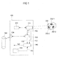
- FIG. 1 shows a block diagram of a device 100 for locating a mobile terminal in a location area.
- the device 100 is for example in the mobile Terminal, like one in the FIG. 2 or FIG. 3 shown smartphone 400, implemented. Subsequently, both on the FIG. 1 , the FIG. 2 and the FIG. 3 Referenced.
- a camera unit 110 of the device 100 occasionally or continuously provides still images of the current environment of the device 100 to a detector 120.
- a detector 120 detects in the still images provided by the camera unit 110 a landmark 202 located in the current environment.
- the landmark 202 can be designed in two dimensions, for example in the form of an imprint on a wall, or three-dimensional, as shown in FIG FIG. 1 is shown. It is advantageous if the landmark 202 is made visually distinctive, so that the detection for the detector 120 is simplified. In addition, each landmark should be installed so that it is clearly visible from as many positions in the local area as possible. It is also conceivable, for example, that the landmark (similar to a lamp) is suspended, so that it can be easily detected by the camera unit.
- the size, the number and the spatial density of the landmarks to be installed depend on the area of the location area and the desired spatial resolution of the location.
- the landmark 202 has a number of uniquely identifiable and opto-electronically detectable characters 202-1, 202-2 and 202-3.
- a two-dimensional barcode such as a QR code or a DataMatrix code.
- Each of these characters are assigned the same or slightly different location data, which is the absolute position of the landmark 202 or the absolute position of the respective character 202-1; 202-2 or 202-3. This location data is contained in a database 300.
- the database 300 includes, for each character 202-1, 202-2 and 202-3, alignment data each indicating in which spatial direction the page of the landmark on which the character in question is mounted.
- the detector 120 detects the landmark 202 in the still image 112, it causes scanning of the barcode 202-2.
- the still image 112 generated by the camera unit 110 is fed to a comparator 130, which, for example, like the detector, is implemented in the form of an image processing unit.
- the comparator 130 determines from the still image 112 the identification of the landmark 200 and the character 202-2.
- the comparator 130 then accesses the database 300 via a link 134 to determine absolute location data and alignment data associated with the identification.
- the database 300 is implemented, for example, on a server (not shown) outside the device 100 and outside the mobile terminal 400. Access to this database 300 takes place, for example, via a mobile radio network present in the local area and / or a WLAN present in the local area and / or via another radio connection.
- the location and orientation data 132 determined by the comparator 130 and the still image from the landmark 202 generated by the camera unit 110 are fed to a computer 140 of the device 100.
- the computer 140 calculates, based on the still image 112 and the location and orientation data 132, a position 142 of the mobile terminal 400 within the location area. For example, the computer 140 first determines based on the still image 132 of the landmark 200 a position of the mobile terminal 400 relative to the landmark 200. To determine the relative position of the mobile terminal 400, the computer 140 extracts from the still image 132, for example, information about the following: a Surface occupying an image of the landmark 200 in the still image 132; a location of the image within the still image 132; and / or a perspective distortion of the figure. Using the absolute location data 132 and the orientation data of the landmark 200, the calculator 140 may then calculate the absolute position of the mobile terminal 400 within the location area.
- the device 100 may include a motion sensor 150 that provides additional data 152 about a current location and / or about an actual acceleration of the mobile device 400.
- a motion sensor 150 that provides additional data 152 about a current location and / or about an actual acceleration of the mobile device 400.
- the motion sensor 150 detects, for example, whether the mobile terminal is in the horizontal or vertical. If such a motion sensor is present, the computer 140 can determine the position of the mobile terminal 400, taking into account the additional data 152 generated by the motion sensor 150.
- the device 100 is particularly suitable for locating the mobile terminal 400 in an indoor area where reception of GPS data is not possible.
- an indoor area is shown in the form of a warehouse having a plurality of aisles and shelves with parcels or the like installed therein.
- the computer 140 may, based on the calculated position 142 on an audiovisual output device in the form of a display 410 of the mobile terminal 400, cause output of position-related content and / or services.
- an audiovisual output device in the form of a display 410 of the mobile terminal 400
- a kind of map 146 of the current environment of the mobile terminal is displayed on the display 410, and graphically highlights the calculated position 142 and / or the current direction of movement.
- the position-related contents / services are on the one hand a navigation instruction 146-1 and on the other hand a position-related advertising content 146-2.
- Such position-related contents / services can also be stored on a database and queried by the mobile terminal 400 with the device 100.
- the present invention supports the use of a so-called. Augmented reality mode on a mobile device.
- FIG. 4 illustrates by way of example and in simplified form a method for locating the mobile terminal 400 in a location area.
- a still image is generated from the location area.
- a second step 720 there is detected a landmark arranged in the location area and imaged in a generated still image.
- the generated still image is assigned location data from a database 300 (step 730).
- a location of the mobile terminal 400 within the location area is determined based on the generated still image and the location data associated therewith (step 740).
Abstract
Description
Die vorliegende Erfindung betrifft das Orten eines mobilen Endgerätes in einem Ortsbereich unter Nutzung von optisch detektierbaren Landmarken. Insbesondere betrifft die vorliegende Erfindung eine entsprechende Vorrichtung zum Orten eines mobilen Endgeräts in einem Ortsbereich gemäß dem Oberbegriff des Patentanspruchs 1 und ein Verfahren zum Orten eines mobilen Endgeräts in einem Ortsbereich gemäß dem Oberbegriff des Patentanspruchs 14. Ferner betrifft die vorliegende Erfindung ein Ortungssystem zum Orten eines mobilen Endgeräts in einem Ortsbereich.The present invention relates to locating a mobile terminal in a location area using optically detectable landmarks. In particular, the present invention relates to a corresponding device for locating a mobile terminal in a location area according to the preamble of patent claim 1 and a method for locating a mobile terminal in a location area according to the preamble of patent claim 14. Further, the present invention relates to a location system for locating a mobile terminal in a local area.
Ein mobiles Endgerät, wie beispielsweise ein Mobiltelefon, ein Smartphone, ein Personal Digital Assistent (PDA), ein Tablet-Computer, ein Notebook oder dergleichen, weist häufig einen Sensor für satellitengestützte Navigation, wie beispielsweise GPS (Global Positioning System), auf, welcher eine Ortung des mobilen Endgeräts im Freien, also im nicht überdachten Raum ermöglicht. Diese Form der Ortung eines mobilen Endgeräts basiert auf dem Empfang von entsprechenden Satellitensignalen. Ein solcher Empfang ist in der Regel nur außerhalb von Gebäuden möglich, während das Orten eines mobilen Endgeräts innerhalb eines Gebäudes (im sogenannten Indoor-Bereich) oder Fahrzeuges häufig nicht möglich ist, da Wände, Decken, Fenster oder Dächer den Empfang der Satellitensignale behindern, mitunter verhindern.A mobile terminal such as a mobile phone, a smart phone, a personal digital assistant (PDA), a tablet computer, a notebook, or the like often has a satellite-based navigation sensor such as GPS (Global Positioning System) a location of the mobile terminal outdoors, so in the uncovered room allows. This form of location of a mobile terminal is based on the receipt of corresponding satellite signals. Such a reception is usually only possible outside of buildings, while the location of a mobile terminal within a building (in the so-called indoor area) or vehicle is often not possible because walls, ceilings, windows or roofs hinder the reception of the satellite signals, sometimes prevent.
Übliche Systeme zum Orten eines mobilen Endgerätes in einem Indoor-Bereich basieren daher nicht auf GPS-Daten, sondern nutzen ein in dem Indoor-Bereich bereits vorhandenes WLAN (Wireless Local Area Network)-System und/oder eigens für die Indoor-Ortung vorgesehene Sender, wie beispielsweise Infrarotsender.Conventional systems for locating a mobile terminal in an indoor area are therefore not based on GPS data, but already use one in the indoor area existing WLAN (Wireless Local Area Network) system and / or specially designed for indoor location transmitter, such as infrared transmitter.
Ein derartiges Indoor-Ortungssystem ist beispielsweise aus der
Nachteilig an derartigen Systemen zum Orten eines mobilen Endgeräts sind die hohen Kosten, die aktive Sender verursachen. Abgesehen von den relativ hohen Kosten für eine solche Infrastruktur hat der oben dargestellte Ansatz weitere Nachteile, wie eine Ungenauigkeit, die beispielsweise durch Reflektionen von WLAN-Signalen und/oder der von den eigens installierten Sender ausgesendeten Signalen an Wänden oder Gegenständen entstehen. Des Weiteren sind derartige Systeme nicht sehr robust, da die von den aktiven Sender ausgestrahlten Signale durch Witterungsänderungen und/oder bewegliche Objekte, wie beispielsweise Menschen, Möbel und Einkaufswagen in nicht vorhersehbarer Weise gestört werden.Disadvantages of such systems for locating a mobile terminal are the high costs which active transmitters cause. Apart from the relatively high cost of such an infrastructure, the approach presented above has other disadvantages, such as inaccuracy caused by, for example, reflections of WLAN signals and / or the signals emitted by the specially installed transmitters on walls or objects. Furthermore, such systems are not very robust because the signals emitted by the active transmitters are disturbed by weather changes and / or moving objects such as people, furniture and shopping carts in an unpredictable manner.
Aus der
Gemäß der
Die
Bei der
Bei der
Schließlich offenbart die
Die oben geschilderten Geräte und Verfahren zum Berechnen einer Position erweisen sich als ungenau und/oder aufwendig.The above-described devices and methods for calculating a position prove to be inaccurate and / or expensive.
Die der vorliegenden Erfindung zugrundeliegende Aufgabe ist es, das Orten eines mobilen Endgeräts unter Vermeidung der oben genannten Nachteile zu verbessern.The object underlying the present invention is to improve the location of a mobile terminal while avoiding the above-mentioned disadvantages.
Gelöst wird diese Aufgabe durch einen Gegenstand gemäß einem der unabhängigen Ansprüche. Merkmale vorteilhafter Weiterbildungen sind in den abhängigen Ansprüchen angegeben.This object is achieved by an article according to one of the independent claims. Features of advantageous developments are specified in the dependent claims.
Einen ersten Aspekt der vorliegenden Erfindung bildet die in Anspruch 1 angegebene Vorrichtung.A first aspect of the present invention is the device specified in claim 1.
Die vorliegende Erfindung schließt die Erkenntnis ein, dass ein mobiles Endgerät, wie beispielsweise ein Mobiltelefon, ein Smartphone, ein PDA, ein Tablet-Computer, ein Notebook oder dergleichen, üblicherweise mit einer Kameraeinheit sowie mit einem leistungsfähigen Rechner ausgestattet ist, die nicht nur übliche Anwendungen ermöglichen, wie beispielsweise mit der Kameraeinheit aufgezeichnete Stehbilder im Originalzustand zu speichern und gegebenenfalls drahtlos zu übertragen, sondern auch solche, bei denen bereits in dem mobilen Endgerät eine Auswertung der Stehbilder vorgenommen wird, wie beispielsweise das Scannen und Decodieren von Codesymbolen, ein Detektieren von Objekten und weitere komplexe Bildverarbeitungsaufgaben.The present invention includes the insight that a mobile terminal such as a mobile phone, a smart phone, a PDA, a tablet computer, a notebook, or the like is usually equipped with a camera unit as well as a powerful computer that is not only conventional Applications allow, for example, to store still images recorded in the original state and, if necessary, to transmit wirelessly with the camera unit, but also those in which an evaluation of the still images is already performed in the mobile terminal, such as the scanning and decoding of code symbols, a detection of Objects and other complex image processing tasks.
Gemäß der vorliegenden Erfindung kann zum Orten des mobilen Endgeräts auf eine aufwendige Infrastruktur, wie beispielsweise eine Anzahl aktiver Sender verzichtet werden. Es sind lediglich einfache und kostengünstige Landmarken zu installieren, zu denen jeweils absolute Ortsdaten auf einer Datenbank hinterlegt sind. Basierend auf diesen Ortsdaten sowie basierend auf einer Analyse des Stehbildes von der Landmarke kann in einfacher und kostengünstiger Weise unter Ausnutzung bereits vorhandener Ressourcen die Position eines mobilen Endgeräts zuverlässig und genau bestimmt werden. Es werden keine weiteren/zusätzlichen Komponenten oder Geräte benötigt, um die Ortung des mobilen Endgeräts zu ermöglichen. Dies gewährleistet niedrige Investitionskosten.According to the present invention can be dispensed with a complex infrastructure, such as a number of active transmitter for locating the mobile terminal. There are only simple and inexpensive landmarks to install, too where absolute location data is stored on a database. Based on this location data as well as based on an analysis of the still image of the landmark, the position of a mobile terminal can be determined reliably and accurately in a simple and cost-effective manner by utilizing already existing resources. No further / additional components or devices are needed to enable the location of the mobile terminal. This ensures low investment costs.
Anders als im Stand der Technik müssen demnach keine aktive Landmarken oder aktive Sender eingesetzt werden. Die Ortung des mobilen Endgeräts erfolgt im Wesentlichen rein opto-elektronisch mit Hilfe von passiven Landmarken, also Landmarken, die insbesondere keinen Energieverbrauch verursachen. Ferner kann die Ortung des mobilen Endgeräts im Wesentlichen durch die Vorrichtung allein vorgenommen werden. Die Datenbank muss lediglich Daten bereithalten, die von der Vorrichtung zum Zwecke der Berechnung der Position abgefragt werden. Somit müssen keine aufwendig zu organisierende serverseitige Berechungen koordiniert werden.Unlike in the prior art therefore no active landmarks or active transmitter must be used. The location of the mobile terminal is essentially purely opto-electronically using passive landmarks, ie landmarks that cause particular no energy consumption. Furthermore, the location of the mobile terminal can essentially be carried out by the device alone. The database only has to hold data that is requested by the device for the purpose of calculating the position. Thus, no complex to be organized server-side calculations need to be coordinated.
Die vorliegende Erfindung kann insbesondere vorteilhaft im Bereich der Indoor-Ortung eingesetzt werden und dort beispielsweise für Navigationsanwendungen, für positionsbezogene Werbung und/oder für positionsbezogene Mehrwertdienste (sogenannte Location-Based-Services). Derartige Dienste können einem Nutzer des mobilen Endgeräts in Abhängigkeit seiner Position auf dem mobilen Endgerät angeboten werden.The present invention can be used particularly advantageously in the field of indoor location and there, for example, for navigation applications, for position-based advertising and / or for position-based value-added services (so-called location-based services). Such services may be offered to a user of the mobile terminal depending on his position on the mobile terminal.
Bei dem mobilen Endgerät kann es sich nicht nur um ein Mobiltelefon, ein Smartphone, ein PDA, ein Tablet-Computer, ein Notebook oder dergleichen handeln, sondern auch um ein Werkzeug oder ein Fahrzeug, welches beispielsweise zu einer Landmarke einen vordefinierten Abstand einhalten soll. Die vorliegende Erfindung kann also nicht nur im Rahmen einer Positionsberechnung eingesetzt werden, sondern auch für die Zwecke einer dieser Positionsberechnung nachgelagerten Positionssteuerung/Positionsreglung zum Steuern/Regeln der Position des mobilen Endgeräts. Für eine solche Positionssteuerung/Positionsreglung kann die zuvor berechnete Position des mobilen Endgeräts zugrunde gelegt werden.The mobile terminal may not only be a mobile phone, a smartphone, a PDA, a tablet computer, a notebook or the like, but also a tool or a vehicle which, for example, is to maintain a predefined distance to a landmark. The present invention can thus be used not only in the context of a position calculation, but also for the purposes of a position control / position control downstream of this position calculation for controlling the position of the mobile terminal. For such a position control / position control, the previously calculated position of the mobile terminal can be used.
Die Vorrichtung zum Orten eines mobilen Endgeräts in einem Ortsbereich ist beispielsweise in dem mobilen Endgerät selbst implementiert. Der Ortsbereich kann ein begrenzter Indoor-Bereich sein, sich jedoch auch im Freien befinden.The device for locating a mobile terminal in a location area is implemented, for example, in the mobile terminal itself. The local area may be a limited indoor area but may be outdoors.
Wesentlich für den Ortsbereich im Sinne der vorliegenden Erfindung ist es, dass in diesem eine oder mehrere Landmarken installiert sind, die derart ausgestaltet sind, dass sie von dem Detektor in einem von der Kameraeinheit erzeugten Stehbild detektiert werden können. Die Position des mobilen Endgeräts innerhalb des Ortsbereichs wird berechnet bezüglich eines zu den Landmarken ortsfesten Koordinatensystems, welches beispielsweise ein fixiertes geodätisches Koordinatensystem oder ein bewegliches Koordinatensystem sein kann, was weiter unten näher erläutert wird.It is essential for the local area within the meaning of the present invention that one or more landmarks are installed in the latter, which are designed such that they can be detected by the detector in a still image generated by the camera unit. The position of the mobile terminal within the location area is calculated with respect to a landmark fixed coordinate system, which may be, for example, a fixed geodetic coordinate system or a movable coordinate system, which will be explained in more detail below.
Landmarken im Sinne der vorliegenden Erfindung sind räumlich-körperliche Gebilde, die von dem Detektor der Vorrichtung als solche erkannt werden können. Beispielsweise weisen die Landmarken eine markante zweidimensionale oder dreidimensionale Struktur- und/oder Farbgebung auf, die das Detektieren erleichtert. Beispielsweise weist eine jeweilige Landmarke eine kugel-, kubus- oder quaderartige Form oder hexagonale Form auf. Bei der Landmarke kann es sich auch um einen Aufdruck auf einer Oberfläche einer Wand oder eines Fahrzeuges handeln.Landmarks within the meaning of the present invention are spatial-physical structures that can be recognized as such by the detector of the device. For example, the landmarks have a striking two-dimensional or three-dimensional structure and / or coloring, which facilitates the detection. For example, a respective landmark on a spherical, cubic or cuboid shape or hexagonal shape. The landmark may also be an imprint on a surface of a wall or a vehicle.
In einer Variante sind die Landmarken örtlich fixiert angeordnet. In dieser Variante drückt die von dem Rechner berechnete Position beispielsweise eine absolute Position des mobilen Endgeräts (beispielsweise in Gestalt eines Smartphones) bezüglich eines fixierten Koordinatensystems, wie ein geodätisches Koordinatensystem, aus. Beispielsweise gibt die berechnete Position Längengradinformationen, Breitengradinformationen und Informationen hinsichtlich einer Höhe des mobilen Endgeräts an.In one variant, the landmarks are arranged locally fixed. In this variant, the position calculated by the computer expresses, for example, an absolute position of the mobile terminal (for example in the form of a smartphone) with respect to a fixed coordinate system, such as a geodetic coordinate system. For example, the calculated position indicates longitude information, latitude information and information regarding a height of the mobile terminal.
In einer anderen Variante ist die Landmarke auf einem beweglichen Objekt angeordnet. In dieser Variante drückt die vom Rechner berechnete Position beispielsweise eine absolute Position des mobilen Endgeräts (beispielsweise in Gestalt eines Werkzeugs oder Fahrzeugs) bezüglich eines Koordinatensystems des beweglichen Objekts, also bezüglich eines beweglichen Koordinatensystems aus. In dieser Variante sind die der Landmarke zugeordneten Ortsdaten ebenfalls Daten, die eine Position der Landmarke bezüglich des Koordinatensystems des beweglichen Objekts angeben. Beispielsweise geben diese Ortsdaten an, dass sich die Landmarke in einem Koordinatenursprung des beweglichen Koordinatensystems befindet. In dieser Variante ist es bevorzugt, dass die Datenbank in der Vorrichtung selbst implementiert ist. Diese Variante ist insbesondere dann von Vorteil, wenn die Positionsberechnung einer Positionssteuerung/ Positionsreglung dienen soll. Beispielsweise kann gefordert sein, dass sich das mobile Endgerät innerhalb eines vorbestimmten Abstandsbereichs zu einer beweglichen Landmarke befinden soll. Dies ist beispielsweise der Fall bei einer Abstandsreglung zum Regeln eines Abstandes zwischen einem ersten Fahrzeug, welches die Landmarke aufweist, und einem mobilen Endgerät in Gestalt eines zweiten Fahrzeugs.In another variant, the landmark is arranged on a moving object. In this variant, the position calculated by the computer expresses, for example, an absolute position of the mobile terminal (for example in the form of a tool or vehicle) with respect to a coordinate system of the mobile object, ie with respect to a movable coordinate system. In this variant, the location data associated with the landmark are also data indicating a position of the landmark relative to the coordinate system of the moving object. For example, this location data indicates that the landmark is in a coordinate origin of the movable coordinate system. In this variant, it is preferred that the database is implemented in the device itself. This variant is particularly advantageous if the position calculation of a position control / Position control should serve. For example, it may be required that the mobile terminal should be within a predetermined distance range to a movable landmark. This is for example the case with a distance control for regulating a distance between a first vehicle having the landmark and a mobile terminal in the form of a second vehicle.
In beiden oben vorgestellten Varianten sind die zugrundeliegenden Prinzipien der Positionsberechnung jedoch identisch zueinander.In both variants presented above, however, the underlying principles of the position calculation are identical to each other.
Der Detektor, der Komparator und/oder der Rechner können allesamt in Gestalt einer an die Kameraeinheit gekoppelte Bildverarbeitungseinheit realisiert sein.The detector, the comparator and / or the computer can all be realized in the form of an image processing unit coupled to the camera unit.
Der Detektor ist beispielsweise ausgebildet, vereinzelt oder kontinuierlich von der Kameraeinheit der Vorrichtung aufgezeichnete Stehbilder der Umgebung des mobilen Endgeräts auszuwerten und dadurch eine Landmarke zu detektieren. Das Erzeugen von Stehbildern erfolgt beispielsweise auf entsprechenden Befehl eines Nutzers des mobilen Endgeräts hin und/oder durch eine bestimmte Programmablaufsteuerung, beispielsweise im Rahmen einer Positionssteuerung oder einer Positionsreglung.By way of example, the detector is designed to evaluate stand-alone images recorded by the camera unit of the device of the surroundings of the mobile terminal and thereby to detect a landmark. The generation of still images takes place, for example, on the appropriate command of a user of the mobile terminal and / or by a specific program sequence control, for example in the context of a position control or a position control.
An dieser Stelle sei erwähnt, dass das Detektieren der Landmarke durch den Detektor insbesondere auch nach Erzeugung des Stehbildes von der Landmarke erfolgen kann. Zum einen ist es möglich, dass der Detektor die Kameraeinheit instruiert, von einer detektierten Landmarke ein Stehbild zu erzeugen, und zum anderen ist es möglich, dass die Kameraeinheit ein oder mehrere Stehbilder von der Umgebung des mobilen Endgeräts aufzeichnet und der Detektor die von der Kameraeinheit erzeugten Stehbilder analysiert und in diesen eine Landmarke detektiert.At this point, it should be mentioned that the detection of the landmark by the detector can be carried out in particular also after the generation of the still image from the landmark. On the one hand, it is possible for the detector to instruct the camera unit to generate a still image from a detected landmark, and, on the other hand, it is possible for the camera unit to record one or more still images of the surroundings of the mobile terminal and for the detector to record that from the camera unit analyzed still images detected and detected in this landmark.
Jedenfalls ordnet ein Komparator dem Stehbild von der detektierten Landmarke Ortsdaten aus einer Datenbank zu. Die Datenbank kann auf dem mobilen Endgerät selbst implementiert sein und/oder auf einem oder mehreren Servern, auf den die Vorrichtung mittels einer dafür vorgesehenen Einrichtung zugreifen kann. Die Datenbank kann beispielsweise als eine Tabelle mit zwei Spalten implementiert sein, bei der die erste Spalte eine Liste von in dem Ortsbereich installierten Landmarken beinhaltet (beispielsweise in Gestalt von Bilddaten und/oder Identifikationsnummern), und bei der die zweite Spalte Ortsdaten, wie beispielsweise Positions- und Ausrichtungsdaten, die die Position und die räumliche Ausrichtung einer jeweiligen Landmarke eindeutig angeben, beinhaltet. Bei diesem Beispiel sind also jeder in dem Ortsbereich installierten Landmarke Positions- und Ausrichtungsdaten eindeutig zugeordnet. Wie oben erläutert ist, beziehen sich diese Daten beispielsweise entweder auf ein fixiertes geodätisches Koordinatensystem oder auf ein bewegliches Koordinatensystem.In any case, a comparator assigns location data from a database to the still image of the detected landmark. The database may be implemented on the mobile terminal itself and / or on one or more servers which the device can access by means of a dedicated device. For example, the database may be implemented as a two-column table, where the first column includes a list of landmarks installed in the location area (eg, in the form of image data and / or identification numbers), and where the second column is location data, such as position and alignment data that uniquely identifies the location and spatial orientation of a particular landmark specify, includes. Thus, in this example, each landmark installed in the location area is uniquely assigned position and orientation data. For example, as discussed above, these data refer to either a fixed geodetic coordinate system or a movable coordinate system.
Der Rechner der Vorrichtung berechnet basierend zum einem auf einer Analyse des Stehbildes und zum anderen basierend auf den diesem zugeordneten Ortsdaten die Position des mobilen Endgeräts innerhalb des Ortsbereichs. Beispielsweise ermittelt der Rechner basierend auf dem Stehbild eine relative Position des mobilen Endgeräts zur Landmarke und gelangt durch Berücksichtigung der absoluten Ortsdaten der Landmarke zur absoluten Position des mobilen Endgeräts.The computer of the device calculates the position of the mobile terminal within the location area based on an analysis of the still image and on the basis of the location data associated therewith. For example, based on the still image, the computer determines a relative position of the mobile terminal to the landmark and arrives at the absolute position of the mobile terminal by taking into account the absolute location data of the landmark.
Erfindungsgemäß ist der Komparator zusätzlich ausgebildet, dem Stehbild von der detektierten Landmarke Ausrichtungsdaten aus der Datenbank zuzuordnen, wobei die Ausrichtungsdaten Informationen über eine räumliche Richtung beinhalten, in die eine in dem Stehbild abgebildete Seite der detektierten Landmarke weist. Ferner ist der Rechner in dieser Ausführungsform ausgebildet, die Position des mobilen Endgeräts basierend auf den dem Stehbild zugeordneten Ausrichtungsdaten zu berechnen. Diese Ausrichtungsdaten geben die räumliche Richtung beispielsweise bezüglich eines fixierten geodätischen Koordinatensystems oder bezügliches eines beweglichen Koordinatensystems an.According to the invention, the comparator is additionally designed to allocate alignment data from the database to the still image of the detected landmark, wherein the alignment data contain information about a spatial direction into which a side of the detected landmark is imaged in the still image. Further, in this embodiment, the computer is configured to calculate the position of the mobile terminal based on the alignment data associated with the still image. This alignment data indicates the spatial direction with respect to, for example, a fixed geodetic coordinate system or a movable coordinate system.
Nachfolgend werden weitere Ausführungsformen der Vorrichtung zum Orten des mobilen Endgeräts in dem Ortsbereich beschrieben. Die zusätzlichen Merkmale der Ausführungsformen können miteinander zur Bildung weiterer Ausführungsformen kombiniert werden, sofern sie nicht ausdrücklich als alternativ zueinander beschrieben sind.In the following, further embodiments of the device for locating the mobile terminal in the location area will be described. The additional features of the embodiments may be combined with each other to form further embodiments unless expressly described as alternative to each other.
Beispielsweise handelt es sich bei der Landmarke um einen optisch markanten Würfel mit sechs Seiten. Die Vorrichtung erkennt in dem Stehbild nicht nur die Landmarke als solche und ordnet dieser absolute Ortsdaten zu, sondern es wird auch und insbesondere erkannt, beispielsweise durch den Detektor, welche Seite oder welche Seiten der detektierten Landmarke in dem Stehbild abgebildet sind. Die Erkennung der abgebildeten Seite in dem Stehbild erfolgt beispielsweise aufgrund jeweils unterschiedlicher Farben, die die verschiedenen Seiten aufweisen können (zum Beispiel: Vorderseite grün; Rückseite blau; rechte Seite gelb etc.). Andere Beispiele hinsichtlich einer Erkennung von Seiten einer Landmarke sind weiter unten angegeben.For example, the landmark is a visually distinctive cube with six sides. The device recognizes in the still image not only the landmark as such and assigns this absolute location data, but it is also and in particular recognized, for example, by the detector, which side or which sides of the detected landmark are mapped in the still image. The detection of the imaged page in the still picture is done, for example, due to respectively different colors that may have the different sides (for example: front green; Backside blue; right side yellow etc.). Other examples regarding recognition of pages of a landmark are given below.
Beispielsweise erkennt der Komparator, dass eine Vorderseite der detektierten Landmarke im Stehbild erfasst worden ist. Auf der Datenbank sind neben den Ortsdaten in dieser Ausführungsform die Ausrichtungsdaten hinterlegt, die in diesem Beispiel angeben, in welche räumliche Richtung die Vorderseite der detektierten Landmarke weist.For example, the comparator recognizes that a front side of the detected landmark has been detected in the still image. In addition to the location data in this embodiment, the database stores the alignment data which, in this example, indicates in which spatial direction the front of the detected landmark points.
In dieser Ausführungsform erfolgt die Berechnung der Position des mobilen Endgeräts basierend auf dem Stehbild also insbesondere durch Berücksichtigung der ermittelten räumlichen Ausrichtung der Seite(n) der Landmarke, die im Stehbild abgebildet ist (sind).In this embodiment, the calculation of the position of the mobile terminal based on the still image thus takes place, in particular, by taking into account the determined spatial orientation of the side (s) of the landmark which is (are) displayed in the still image.
Diese Ausführungsform erlaubt eine deutlich exaktere Bestimmung der Position des mobilen Endgeräts.This embodiment allows a much more accurate determination of the position of the mobile terminal.
In einer weiteren Ausführungsform ist der Rechner der Vorrichtung weiter ausgebildet, basierend auf dem Sehbild eine Ausrichtung des mobilen Endgeräts relativ zur detektierten Landmarke zu berechnen.In a further embodiment, the computer of the device is further configured to calculate an orientation of the mobile terminal relative to the detected landmark based on the visual image.
Die Ausrichtung des mobilen Endgeräts relativ zur detektierten Landmarke gibt beispielweise eine Richtung einer gedanklichen Strecke an, die das mobile Endgerät und einen Mittelpunkt der detektierten Landmarke miteinander verbindet.The orientation of the mobile terminal relative to the detected landmark indicates, for example, a direction of a mental path connecting the mobile terminal and a center of the detected landmark.
Beispielsweise vergleicht der Rechner zum Berechnen der Ausrichtung die Abbildung der Landmarke innerhalb des Stehbildes mit einer auf der Datenbank hinterlegten oder selbst berechneten Abbildung einer orthografischen Ansicht der Landmarke. Beispielsweise sind Formen und Größen der Landmarken normiert und dem Rechner bekannt. Durch einen solchen Vergleich ermittelt der Rechner einen Verzerrungsgrad zwischen der Abbildung der orthografischen Ansicht und der tatsächlichen Abbildung der detektierten Landmarke in dem Stehbild. Dieser Verzerrungsgrad gibt Aufschluss darüber, in welcher Ausrichtung sich die Kameraeinheit - und damit die Vorrichtung - zur Landmarke befindet. Beispielsweise berechnet der Rechner sodann durch Transformation von Koordinaten eines Kamerakoordinatensystems der Kameraeinheit, die die Abbildung der Landmarke innerhalb des Stehbildes definieren, in Koordinaten, die zum Definieren einer Abbildung einer orthografischen Ansicht der Landmarke nötig wären, die Ausrichtung des mobilen Endgeräts relativ zur detektierten Landmarke.For example, to calculate the orientation, the computer compares the image of the landmark within the still image with a map of an orthographic view of the landmark deposited or even computed in the database. For example, shapes and sizes of the landmarks are normalized and known to the computer. By such a comparison, the computer determines a degree of distortion between the image of the orthographic view and the actual image of the detected landmark in the still image. This degree of distortion provides information about the orientation of the camera unit - and thus the device - to the landmark. For example, by transforming coordinates of a camera coordinate system of the camera unit that define the landmark image within the still image, the calculator then calculates coordinates for defining a landmark Illustration of an orthographic view of the landmark would be necessary, the orientation of the mobile terminal relative to the detected landmark.
Umfasst die Datenbank auch Daten, die Informationen über Formen und Größen der in dem Ortsbereich angeordneten Landmarken beinhalten, so ist der Komparator in einer bevorzugten Ausführungsform der Vorrichtung dazu ausgebildet, auch derartige Daten dem Stehbild von der detektierten Landmarke zuzuordnen.If the database also comprises data containing information about shapes and sizes of the landmarks arranged in the location area, the comparator in a preferred embodiment of the apparatus is designed to also assign such data to the still image of the detected landmark.
Diese Ausführungsform erlaubt eine noch exaktere Bestimmung der Position des mobilen Endgeräts. Wird die Vorrichtung beispielsweise zum Zwecke der Navigation eingesetzt, so können ferner positionsbezogene Inhalte, wie beispielsweise eine Darstellung der aktuellen Umgebung des mobilen Endgeräts unter Berücksichtigung der Ausrichtung des mobilen Endgeräts für den Nutzer dargestellt werden.This embodiment allows an even more accurate determination of the position of the mobile terminal. If the device is used, for example, for the purpose of navigation, it is also possible to display position-related contents, such as a representation of the current environment of the mobile terminal, taking into account the orientation of the mobile terminal for the user.
In einer weiteren besonders bevorzugten Ausführungsform weist die Landmarke eine Anzahl eindeutig identifizierbarer und opto-elektronisch detektierbarer Zeichen, wie einen ein- oder mehrdimensionalen Barcode, insbesondere einen Strichcode, einen DataMatrix-Code, einen Maxicode und/oder einen Aztec-Code auf. Neben einem solchen ein- oder mehrdimensionalen Barcode sind auch andere eindeutig identifizierbare und opto-elektronisch detektierbare Zeichen geeignet. Beispielsweise handelt es sich bei dem eindeutig identifizierbaren und opto-elektronisch detektierbaren Zeichen um ein definiert gestaltetes Farb-, Schwarz-Weiß- und/oder Graustufen-Muster, welches von der Vorrichtung detektiert und identifiziert werden kann. Letztere Variante bietet die Möglichkeit, die Landmarken individuell zu gestalten, beispielsweise derart, dass diese mit einem Layout eines Firmenlogos harmonieren.In a further particularly preferred embodiment, the landmark has a number of uniquely identifiable and opto-electronically detectable characters, such as a one- or multi-dimensional barcode, in particular a barcode, a DataMatrix code, a Maxicode and / or an Aztec code. In addition to such a one-dimensional or multidimensional barcode, other clearly identifiable and opto-electronically detectable characters are also suitable. For example, the clearly identifiable and opto-electronically detectable character is a defined color, black-and-white and / or grayscale pattern, which can be detected and identified by the device. The latter variant offers the possibility to design the landmarks individually, for example in such a way that they harmonize with a layout of a company logo.
In dieser Ausführungsform ist die Kameraeinheit ausgebildet, das Stehbild auch von der Anzahl opto-elektronisch detektierbarer Zeichen zu erzeugen. Die Kameraeinheit ist also ausgebildet, ein oder mehrere opto-elektronisch detektierbare Zeichen mit dem Stehbild zu erfassen. In dieser Variante erfolgt also beispielsweise ein Scannen des ein- oder mehrdimensionalen Codes.In this embodiment, the camera unit is designed to also generate the still image from the number of opto-electronically detectable characters. The camera unit is thus designed to detect one or more opto-electronically detectable characters with the still image. In this variant, for example, a scanning of the one-dimensional or multidimensional code takes place.
In der oben dargestellten Ausführungsform der erfindungsgemäßen Vorrichtung kann der Komparator schneller, einfacher und zuverlässiger dem Stehbild Ortsdaten und ggf. weitere Daten, wie die oben genannten Ausrichtungsdaten, aus einer Datenbank zuordnen. Durch das eindeutig identifizierbare und opto-elektronisch detektierbare Zeichen auf der Landmarke ist die Landmarke selbst eindeutig identifizierbar. Zum Zuordnen von Ortsdaten muss also in der Datenbank nicht aufwendig nach einer Abbildung einer Landmarke gesucht werden, die dem aktuellen Stehbild am nächsten kommt, sondern der Komparator ermittelt aus dem Zeichen die eindeutige Identifikation der Landmarke und fragt bezüglich der ermittelten Identifikation Ortsdaten aus der Datenbank ab.In the above-described embodiment of the device according to the invention, the comparator can allocate location data and possibly further data, such as the above-mentioned alignment data, from a database more quickly, easily and reliably to the still image. By the clearly identifiable and opto-electronically detectable Sign on the landmark, the landmark itself is clearly identifiable. In order to allocate location data, therefore, it is not necessary to search extensively in the database for a map of a landmark which comes closest to the current still image; instead, the comparator determines the unique identification of the landmark from the character and queries location data from the database for the identified identification ,
An dieser Stelle wird nochmals ein wesentlicher Vorteil der vorliegenden Erfindung deutlich: Bei den installierten Landmarken kann es sich um passive Landmarken handeln, die nicht aktiv Funksignale betreffend eine Landmarkenidentifikation / Landmarkenkennung ausstrahlen müssen (und dadurch Energie verbrauchen), sondern lediglich eine leicht detektierbare körperliche Form sowie bevorzugt wenigstens ein eindeutig identifizierbares und opto-elektronisch detektierbares Zeichen aufweisen. Auch bei der oben angesprochenen Positionssteuerung/Positionsreglung kann auf eine Aussendung von Infrarotsignalen, Radarsignalen oder sonstigen Funksignalen, wie es gemäß dem Stand der Technik üblich ist, verzichtet werden. Allein durch Detektieren und fotografisches Erfassen einer passiven Landmarke und der sodann erfolgenden Verarbeitung der Stehbilddaten kann die Position des mobilen Endgeräts zuverlässig und genau berechnet werden. Die Ermittlung der der Landmarke zugeordneten Ortsdaten erfolgt dabei selbsttätig durch die Vorrichtung. Die Datenbank enthält lediglich die Ortsdaten und optional die oben genannten Ausrichtungsdaten und/oder Daten mit Informationen hinsichtlich der Formen und Größen der Landmarken, muss aber keine Berechnungen zum Orten des mobilen Endgeräts durchführen.At this point, again, a significant advantage of the present invention is clear: The installed landmarks may be passive landmarks that do not actively broadcast radio signals regarding a landmark identification / landmark identification (and thereby consume energy), but only an easily detectable physical form and preferably have at least one clearly identifiable and optoelectronically detectable character. Even with the above-mentioned position control / position control can be dispensed with a transmission of infrared signals, radar signals or other radio signals, as is common in the prior art. By detecting and photographing a passive landmark and then processing the still image data, the position of the mobile terminal can be reliably and accurately calculated. The determination of the landmark associated location data is carried out automatically by the device. The database contains only the location data and optionally the above-mentioned registration data and / or data with information regarding the shapes and sizes of the landmarks, but does not have to perform any calculations for locating the mobile terminal.
Gemäß dem Vorstehenden ist der Komparator in einer bevorzugten Variante der Vorrichtung ausgebildet, aus dem Stehbild eine Identifikation/eine Kennung der detektierten Landmarke zu ermitteln und basierend auf dieser Identifikation/Kennung dem Stehbild die Ortsdaten zuzuordnen. Dies erleichtert sowohl die Zuordnung von Ortsdaten als solche als auch den Aufbau der Datenbank.According to the above, in a preferred variant of the device, the comparator is designed to determine from the still image an identification / identifier of the detected landmark and, based on this identification / identifier, to associate the location data with the still image. This facilitates both the assignment of location data as such and the structure of the database.
In einer Ausführungsform ist der Komparator ausgebildet, einem jeweiligen der in dem Stehbild abgebildeten Anzahl opto-elektronisch detektierbarer Zeichen die Ausrichtungsdaten zuzuordnen. Diese Ausführungsform soll an einem Beispiel verdeutlicht werden: Die detektierte Landmarke weist beispielsweise eine Quaderform auf. Auf mehreren Seiten der quaderförmigen Landmarke sind jeweils opto-elektronisch detektierbare Zeichen in Gestalt von Barcodes angebracht. Alle Barcodes der quaderförmigen Landmarke haben eine Identifikation, der jeweils dieselben Ortsdaten in der Datenbank zugeordnet sind. Im Falle einer räumlich sehr großen Landmarke können die Ortsdaten auch leicht voneinander abweichen, so dass die unterschiedlichen Positionen der Barcodes auf der Landmarke berücksichtigt werden können. Zusätzlich sind jedem Barcode Ausrichtungsdaten zugeordnet, die angeben, auf welcher Seite der Landmarke ein jeweiliger Barcode angebracht sind. Durch Erfassung eines dieser Barcodes kann die Vorrichtung nun also nicht nur erkennen, dass sich das mobile Endgerät in der Nähe und in einem bestimmten Abstand zur Landmarke befindet, sondern auch, zur welchen Seite der Landmarke das mobile Endgerät weist. Somit kann das Orten des mobilen Endgeräts, also das Bestimmen der Position des mobilen Endgeräts, in dieser Ausführungsform noch exakter erfolgen.In one embodiment, the comparator is configured to associate the alignment data with a respective one of the plurality of opto-electronically detectable characters imaged in the still image. This embodiment will be illustrated by way of example: The detected landmark has, for example, a cuboid shape. Opto-electronically detectable characters in the form of barcodes are each mounted on several sides of the cuboid landmark. All barcodes of the cuboid landmark have an identification, which are each assigned the same location data in the database. In the case of a spatially very large landmark, the location data may also differ slightly so that the different positions of the bar codes on the landmark can be taken into account. In addition, each barcode is associated with alignment data indicating which side of the landmark a respective barcode is attached to. By detecting one of these bar codes, the device can now not only recognize that the mobile terminal is located near and at a certain distance from the landmark, but also to which side of the landmark the mobile terminal points. Thus, the location of the mobile terminal, that is to say the determination of the position of the mobile terminal, can take place more precisely in this embodiment.
Dadurch, dass die Ausrichtungsdaten eindeutig identifizierbaren und auf der Landmarke angebrachten Zeichen zugeordnet sind, wird die erhöhte Genauigkeit beim Orten in einfacher und praktikabler Weise erzielt.By associating the registration data with uniquely identifiable and tagged indicia, the increased accuracy in locating is achieved in a simple and practical manner.
In einer Ausführungsform der Vorrichtung nutzt der Rechner zum Berechnen der Position des mobilen Endgeräts neben den der Landmarke (oder dem darauf angebrachten Zeichen) zugeordneten Ortsdaten erste Ausrichtungsdaten, die einem ersten opto-elektronisch detektierbaren Zeichen der Landmarke zugeordnet sind und zweite Ausrichtungsdaten, die einem zweiten opto-elektronisch detektierbaren Zeichen der Landmarke zugeordnet sind. Dadurch, dass der Rechner Ausrichtungsdaten von zwei oder mehreren Zeichen beim Berechnen der Position nutzt, kann die Genauigkeit abermals erhöht werden.In one embodiment of the apparatus, the computer for computing the position of the mobile terminal next to the location data associated with the landmark (or the character attached thereto) uses first alignment data associated with a first optoelectronically detectable landmark symbol and second alignment data associated with a second landmark opto-electronically detectable signs of the landmark are assigned. By using the alignment data of two or more characters in computing the position, the accuracy can be increased again.
Es ist insgesamt bevorzugt, dass der Rechner der Vorrichtung ausgebildet ist, basierend auf dem Stehbild von der Landmarke zunächst eine relative Position des mobilen Endgeräts zur Landmarke zu berechnen und basierend auf der berechneten relativen Position und den Ortsdaten eine absolute Position des mobilen Endgeräts innerhalb des Ortsbereichs zu berechnen. Wie oben erläutert, ist es bevorzugt, dass diese absolute Position wahlweise eine Position innerhalb eines fixierten geodätischen Koordinatensystems angibt oder innerhalb eines beweglichen Koordinatensystems.It is generally preferred that the computer of the device is designed to first calculate a relative position of the mobile terminal to the landmark based on the still image of the landmark, and based on the calculated relative position and the location data, an absolute position of the mobile terminal within the location area to calculate. As explained above, it is preferable that this absolute position selectively indicates a position within a fixed geodetic coordinate system or within a movable coordinate system.
Das Orten des mobilen Endgeräts erfolgt demnach bevorzugt in zwei Hauptschritten. In dem ersten Schritt werden absolute Ortsdaten einer in der Nähe des mobilen Endgeräts befindlichen Landmarke ermittelt. Dies erfolgt beispielsweise durch fotografisches Erfassen eines auf der Landmarke angebrachten opto-elektronisch detektierbaren Zeichens und durch Bestimmen der diesem Zeichen zugeordneten Ortsdaten. Danach werden basierend auf einer Bildverarbeitung des von der Kameraeinheit erzeugten Stehbildes von der Landmarke relative Ortsdaten ermittelt, die Informationen darüber liefern, in welcher Position sich das mobile Endgerät relativ zur Landmarke befindet. Die relative Position des mobilen Endgeräts zur Landmarke ist beispielsweise definiert durch den Abstand des mobilen Endgeräts zur Landmarke, durch einen Winkel, in dem sich das mobile Endgerät relativ zur Landmarke befindet und/oder durch einen Höhenunterschied zwischen dem mobilen Endgerät und der Landmarke. Die Berechnung der Position kann insbesondere auch erfolgen durch zusätzliche Berücksichtigung der ebenfalls dem opto-elektronisch detektierbaren Zeichen zugeordneten Ausrichtungsdaten.The locations of the mobile terminal are therefore preferably in two main steps. In the first step, absolute location data of a landmark located near the mobile terminal is determined. This is done for example by photographic Detecting an optoelectronically detectable character mounted on the landmark and determining the location data associated with that character. Thereafter, based on an image processing of the still image generated by the camera unit from the landmark relative location data is determined, which provide information about the position in which the mobile terminal is relative to the landmark. The relative position of the mobile terminal to the landmark is defined, for example, by the distance of the mobile terminal to the landmark, by an angle at which the mobile terminal is relative to the landmark and / or by a height difference between the mobile terminal and the landmark. In particular, the position can also be calculated by additional consideration of the alignment data also assigned to the optoelectronically detectable character.
Beispielsweise ist der Rechner dieser Variante ausgebildet, zum Bestimmen der relativen Position des mobilen Endgeräts dem Stehbild der Landmarke Informationen über das Folgende zu entnehmen: eine Fläche, die eine Abbildung der Landmarke in dem Stehbild beansprucht; eine Lage der Abbildung innerhalb des Stehbildes; und/oder eine perspektivische Verzerrung der Abbildung. Ebenso ist es möglich, dass der Rechner einen Zoomfaktor, den die Kameraeinheit zur Erzeugung des Stehbildes von der Landmarke verwendet hat, und/oder Einstellungsdaten der Kameraeinheit hinsichtlich eines oder mehrerer Kameraparameter bei der Bestimmung der relativen Position des mobilen Endgeräts berücksichtigt. Beispielsweise wird vor dem Ortungsvorgang eine Kalibrierung der Kameraeinheit veranlasst. Die Kalibrierung kann entweder selbsttätig durch die Vorrichtung selbst veranlasst werden oder aber auf entsprechenden Befehl eines Nutzers der Vorrichtung hin. Die Kalibrierung der Kameraeinheit kann in üblicher Manier erfolgen, beispielsweise durch Positionieren der Kameraeinheit in eine vordefinierte Position und anschließendes fotografisches Erfassen vordefinierter optischer Fixpunkte. Durch die Kalibrierung kann vermieden werden, dass die Genauigkeit der Positionsberechnung aufgrund von optischen Fehlern, wie Linsenfehler, Fehleinstellungen der Kameraeinheit und/oder einer nicht kalibrierten Sensorik beeinträchtigt wird.For example, in order to determine the relative position of the mobile terminal, the computer of this variant is designed to take information about the following from the still image of the landmark: an area which claims an image of the landmark in the still image; a location of the image within the still image; and / or a perspective distortion of the figure. It is also possible for the computer to take into account a zoom factor which the camera unit used to generate the still image from the landmark and / or adjustment data of the camera unit for one or more camera parameters in determining the relative position of the mobile terminal. For example, a calibration of the camera unit is initiated before the locating process. The calibration may either be initiated automatically by the device itself or upon appropriate instruction from a user of the device. The calibration of the camera unit can be done in a conventional manner, for example by positioning the camera unit in a predefined position and subsequent photographic detection of predefined optical fixed points. The calibration can avoid that the accuracy of the position calculation due to optical errors, such as lens errors, camera unit misadjustments and / or a non-calibrated sensors is affected.
Bereits weiter oben sind Möglichkeiten angegeben, wie der der Rechner zum Bestimmen der relativen Position die perspektivische Verzerrung/den Verzerrungsgrad berechnen kann.Possibilities are already indicated above how the calculator can calculate the perspective distortion / degree of distortion to determine the relative position.
Weiter ist es bevorzugt, dass der Rechner zum Berechnen der relativen Position ausgebildet ist, eine Analyse des Stehbildes beispielsweise vorzunehmen gemäß den Grundzügen der Lehre von
In einer weiteren bevorzugten Ausführungsform umfasst die Vorrichtung zusätzlich einen Bewegungssensor, beispielsweise in Gestalt eines Beschleunigungssensors und/oder Lagesensors, der ausgebildet ist, Zusatzdaten über eine aktuelle Lage und/oder eine aktuelle Geschwindigkeit und/oder eine aktuelle Beschleunigung des mobilen Endgeräts zu generieren, wobei der Rechner ausgebildet ist, die Position des mobilen Endgeräts die Position und/oder die Ausrichtung des mobilen Endgeräts unter Berücksichtigung der Zusatzdaten zu berechnen. Dies erlaubt eine genauere und zuverlässigere Bestimmung der Position des mobilen Endgeräts. Ein derartiger Bewegungssensor befindet sich ebenfalls üblicherweise in einem herkömmlichen mobilen Endgerät, so dass die verbesserte Positionsbestimmung wiederum unter Ausnutzung bereits gegenwärtiger Komponenten erzielt werden kann.In a further preferred embodiment, the device additionally comprises a motion sensor, for example in the form of an acceleration sensor and / or position sensor, which is designed to generate additional data on a current position and / or a current speed and / or an actual acceleration of the mobile terminal the computer is designed to calculate the position of the mobile terminal, the position and / or the orientation of the mobile terminal taking into account the additional data. This allows a more accurate and reliable determination of the position of the mobile terminal. Such a motion sensor is also usually located in a conventional mobile terminal, so that the improved position determination can again be achieved by utilizing already existing components.
In einer weiteren Ausführungsform ist der Detektor ausgebildet, basierend auf einer räumlich-körperlich Ausgestaltung der Landmarke die Landmarke als solche zu detektieren. Wie bereits oben erwähnt kann die Landmarke zweidimensional ausgestaltet sein, beispielsweise in Gestalt eines Aufdrucks auf einer Oberfläche einer Wand oder eines Fahrzeugs, oder aber dreidimensional, wie beispielsweise kugel-, kubus- oder quaderförmig oder eine hexagonale Form aufweisen. Es ist von Vorteil, wenn die Landmarken optisch markant sind, beispielsweise eine Gestalt eines Würfels mit farbigen Kanten aufweisen, damit sie von dem Detektor leicht erkannt werden können.In a further embodiment, the detector is designed to detect the landmark as such, based on a spatial-physical configuration of the landmark. As already mentioned above, the landmark may be designed in two dimensions, for example in the form of an imprint on a surface of a wall or of a vehicle, or else in three dimensions, such as spherical, cuboid or cuboid or hexagonal. It is advantageous if the landmarks are visually distinctive, for example, have a shape of a cube with colored edges, so that they can be easily recognized by the detector.
In einer weiteren Ausführungsform ist die Vorrichtung ausgebildet, die Position des mobilen Endgeräts unter Berücksichtigung von zwei oder mehreren detektierten Landmarken vorzunehmen. In dieser Variante erfolgt das Orten des mobilen Endgeräts mit erhöhter Genauigkeit, da beispielsweise ein berechneter erster relativer Positionsbereich zu einer ersten Landmarke und ein berechneter zweiter relativer Positionsbereich zu einer zweiten Landmarke eine genauere Aussage über den aktuellen Ort des mobilen Endgeräts zulassen.In a further embodiment, the device is designed to make the position of the mobile terminal taking into account two or more detected landmarks. In this variant, the location of the mobile terminal takes place with increased accuracy, since, for example, a calculated first relative position range to a first landmark and a calculated second relative position range to a second landmark allow a more accurate statement about the current location of the mobile terminal.
In einer bevorzugten Variante ist die Datenbank mit den Ortsdaten und optional mit den Ausrichtungsdaten und/oder mit den Daten hinsichtlich Form- und Größe der Landmarken und/oder mit den Abbildungen normierter Ansichten von Landmarken auf einem Server hinterlegt. Die Vorrichtung weist dabei ein Kopplungsglied auf über welches der Komparator zum Zwecke der Zuordnung auf den Server zugreifen kann. Beispielsweise ist der Komparator also ausgebildet, über einen gegenwärtiges Mobilfunknetz und/oder über ein WLAN und/oder über eine sonstige Funkverbindung auf den Server zuzugreifen und dort die Ortsdaten und ggf. weiteren Daten, die der detektierten Landmarke zugeordnet sind zu ermitteln und dem Rechner der Vorrichtung für die Zwecke der Bestimmung der Position des mobilen Endgeräts zuzuführen. Beispielsweise ist das Kopplungsglied also durch ein übliches Senderempfängerteil eines mobilen Endgeräts realisiert.In a preferred variant, the database with the location data and optionally with the orientation data and / or with the data regarding shape and size of the landmarks and / or with the images of standardized views of landmarks is stored on a server. In this case, the device has a coupling element via which the comparator can access the server for the purpose of the assignment. For example, the comparator is thus configured to access the server via a current mobile radio network and / or via a WLAN and / or via another radio connection and there to determine the location data and possibly further data associated with the detected landmark and the computer of Supply device for the purpose of determining the position of the mobile terminal. For example, the coupling member is thus realized by a conventional transmitter-receiver part of a mobile terminal.
In einer bevorzugten Variante ist der Rechner zusätzlich ausgebildet, basierend auf der berechneten Position auf einer audiovisuellen Ausgabevorrichtung des mobilen Endgeräts, wie beispielsweise ein Lautsprecher und/oder ein Display, ein Ausgeben von positionsbezogenen Inhalten und/oder Diensten, wie einer Abbildung einer aktuellen Umgebung des mobilen Endgeräts und/oder ortsbezogenen Informationen und/oder einen Werbeinhalt, zu veranlassen. Für einen Nutzer des mobilen Endgeräts ist es von Vorteil, wenn die berechnete Position als solche in dem Display visualisiert wird, beispielsweise als Bildelement in einem dargestellten Kartenabschnitt oder durch Angabe der aktuellen Adresse und/oder in Raumkoordinaten und/oder der aktuellen Lage im Gebäude (beispielsweise "14. Stock, Zimmer 14.231"). Das Ausgeben von positionsbezogenen Inhalten und/oder Diensten erfolgt in üblicher Manier, mit dem wesentlichen Unterschied, dass die Position des mobilen Endgeräts in der hier vorgestellten Art und Weise berechnet worden ist.In a preferred variant, the computer is additionally designed based on the calculated position on an audiovisual output device of the mobile terminal, such as a loudspeaker and / or a display, outputting position-related content and / or services, such as a picture of a current environment of the mobile terminal and / or location-related information and / or advertising content. For a user of the mobile terminal, it is advantageous if the calculated position is visualized as such in the display, for example as a picture element in a displayed map section or by specifying the current address and / or in spatial coordinates and / or the current situation in the building ( for example "14th floor, room 14.231"). The issuing of position-related contents and / or services takes place in the usual manner, with the essential difference that the position of the mobile terminal has been calculated in the manner presented here.
In einer weiteren Variante ist der Rechner ausgebildet, das Ausgeben von positionsbezogenen Inhalten und/oder Diensten unter Zuhilfenahme der bestimmten Ausrichtung und/oder der dem Stehbild zugeordneten Ausrichtungsdaten und/oder der Zusatzdaten zu veranlassen. Befindet sich das mobile Endgerät beispielsweise in Blickrichtung zu einer ersten Seite der Landmarke, veranlasst der Rechner das Ausgeben von ersten positionsbezogenen Inhalten und/oder Diensten. Befindet sich das mobile Endgerät hingegen in Blickrichtung zu einer anderen Seite derselben Landmarke oder in anderer Blickrichtung zur selben Seite derselben Landmarke, so kann es zweckmäßig sein, dass der Rechner das Ausgeben von zweiten positionsbezogenen Inhalten und/oder Diensten veranlasst, die sich von den ersten positionsbezogenen Inhalten und/oder Diensten unterscheiden. Diese Variante ist beispielsweise vorteilhaft für eine Anwendung in einer Verkaufshalle, wie ein Supermarkt, wo die Landmarke von verschiedenen Gängen aus erkannt werden kann, in welchen verschiedene Produkttypen zum Verkauf angeboten werden. Dann ist es zweckmäßig, dass beispielsweise Werbeinhalte in Abhängigkeit der dem Stehbild zugeordneten Ausrichtungsdaten angezeigt/ausgegeben werden.In a further variant, the computer is designed to initiate the outputting of position-related contents and / or services with the aid of the specific orientation and / or the orientation data and / or the additional data assigned to the still image. If the mobile terminal is located, for example, in the viewing direction to a first side of the landmark, the computer causes the issuing of first position-related contents and / or services. If, however, the mobile terminal is in the viewing direction to another side of the same landmark or in another direction to the same side of the same landmark, it may be appropriate that the computer causes the issuing of second position-related content and / or services, which differs from the first position-related content and / or services. This variant is advantageous, for example, for an application in a sales hall, such as a supermarket, where the landmark can be recognized from different aisles in which different product types are offered for sale. It is then expedient that, for example, advertising content is displayed / output in dependence on the orientation data assigned to the still image.
Ein mobiles Endgerät, welches eine Vorrichtung gemäß dem ersten Aspekt der vorliegenden Erfindung aufweist, bildet den zweiten Aspekt der Erfindung. Das mobile Endgerät ist damit ausgebildet, ohne zusätzliche Hardware in zuverlässiger und exakter Weise seine aktuelle Position zu bestimmen, insbesondere in einem Ortsbereich, der eine Anzahl der oben beschriebenen Landmarken aufweist.A mobile terminal comprising a device according to the first aspect of the present invention constitutes the second aspect of the invention. The mobile terminal is adapted to reliably and accurately determine its current position without additional hardware, in particular in a location area having a number of the landmarks described above.
Ein Verfahren zum Orten eines mobilen Endgeräts in einem Ortsbereich gemäß dem Patentanspruch 14 bildet den dritten Aspekt der vorliegenden Erfindung.A method for locating a mobile terminal in a location area according to claim 14 forms the third aspect of the present invention.
Das Verfahren des dritten Aspektes der vorliegenden Erfindung teilt die Vorteile der Vorrichtung des ersten Aspektes der vorliegenden Erfindung. Bevorzugte Ausführungsvarianten des Verfahrens entsprechen dem oben geschilderten Ausführungsformen der Vorrichtung zum Orten des mobilen Endgeräts. Merkmale dieser bevorzugten Ausführungsvarianten sind insbesondere den Unteransprüchen zu entnehmen.The method of the third aspect of the present invention shares the advantages of the device of the first aspect of the present invention. Preferred embodiments of the method correspond to the above-described embodiments of the device for locating the mobile terminal. Features of these preferred embodiments are particularly apparent from the dependent claims.
In einer bevorzugten Ausführungsform ist das Verfahren des dritten Aspektes der vorliegenden Erfindung ein Betriebsverfahren zum Betreiben eines mobilen Endgeräts. In einer weiteren bevorzugten Ausführungsform bildet das Verfahren zum Orten eines mobilen Endgeräts einen Teil eines Positionssteuerungsverfahren oder eines Positionsreglungsverfahrens zum Steuern/Regeln einer Position eines mobilen Endgeräts.In a preferred embodiment, the method of the third aspect of the present invention is an operating method for operating a mobile terminal. In a further preferred embodiment, the method for locating a mobile terminal part of a position control method or a position control method for controlling a position of a mobile terminal.
Ein Computerprogramm, welches maschinenlesbaren Code aufweist, der, wenn er auf einer Vorrichtung ausgeführt wird, ausgebildet ist, die Vorrichtung dazu zu veranlassen, das Verfahren des dritten Aspekts der vorliegenden Erfindung durchzuführen, bildet einen vierten Aspekt der vorliegenden Erfindung.A computer program having machine-readable code, which, when executed on a device, is adapted to cause the device to perform the method of the third aspect of the present invention constitutes a fourth aspect of the present invention.
Das Computerprogramm ist beispielsweise in Gestalt einer sogenannten "App" für ein mobiles Endgerät ausgeführt. Die App ist bevorzugt dazu ausgestaltet, in üblicher Manier von einem Nutzer des mobilen Endgeräts (beispielsweise in Gestalt eines Smartphones) aufgerufen zu werden. Während des Programmablaufs der App hält der Nutzer das mobile Endgerät in den Raum (oder schwenkt es durch den Raum), so dass die Kameraeinheit vereinzelt oder fortwährend Stehbilder von dem Ortsbereich aufzeichnen kann. Nach einem solchen Vorgang beginnt die Auswertung der aufgezeichneten Stehbilder, welche mit der Ausgabe der berechneten Position des mobilen Endgeräts endet. Sodann kann von der App vorgesehen sein, dass auf dem mobilen Endgerät positionsbezogene Inhalte/Dienste, wie Navigationsanweisungen, Ortsinformationen, Werbeinformationen etc., angezeigt und/oder akustisch ausgegeben werden.The computer program is embodied, for example, in the form of a so-called "app" for a mobile terminal. The app is preferably designed to be called in the usual manner by a user of the mobile terminal (for example in the form of a smartphone). During the program execution of the app, the user holds the mobile terminal in the room (or pans it through the room) so that the camera unit can occasionally or continuously record still pictures of the location area. After such a process, the evaluation of the recorded still pictures, which ends with the output of the calculated position of the mobile terminal, begins. It can then be provided by the app that on the mobile terminal position-related content / services, such as navigation instructions, location information, advertising information, etc., are displayed and / or output acoustically.
Das Computerprogramm ist in einer anderen Variante als Programmmodul eines Positionssteuerungs- oder Positionsreglungsprogramms ausgestaltet. Dabei stellt beispielsweise eine Differenz zwischen einer vorgegebenen Soll-Position eines mobilen Endgeräts und einer erfindungsgemäß berechneten Ist-Position des mobilen Endgeräts eine Eingangsgröße für das Positionssteuerungs- oder Positionsreglungsprogramms dar.The computer program is configured in another variant as a program module of a position control or position control program. In this case, for example, a difference between a predetermined desired position of a mobile terminal and an actual position of the mobile terminal calculated according to the invention represents an input variable for the position control or position control program.
Ein maschinenlesbares Speichermedium, welches maschinenlesbaren Programmcode aufweist, der ausgestaltet ist, auf einem mobilen Endgerät ausgeführt zu werden und das mobile Endgerät bei der Ausführung des Programmcodes dazu zu veranlassen, das Verfahren des dritten Aspektes der vorliegenden Erfindung durchzuführen, bildet einen fünften Aspekt der vorliegenden Erfindung.A machine-readable storage medium having machine-readable program code adapted to be executed on a mobile terminal and causing the mobile terminal to execute the method of the third aspect of the present invention in executing the program code forms a fifth aspect of the present invention ,
Gemäß einem sechsten Aspekt der vorliegenden Erfindung wird ein Ortungssystem zum Orten eines mobilen Endgeräts in einem Ortsbereich vorgeschlagen. Das Ortungssystem weist eine Vorrichtung des ersten oder zweiten Aspektes der vorliegenden Erfindung auf sowie eine Anzahl Landmarken, die jeweils ausgestaltet sind, von der Vorrichtung mittels einer Stehbildaufnahme als solche detektiert zu werden. Ferner beinhaltet das System eine Datenbank, die bezogen auf eine jeweilige Landmarke Ortsdaten enthält, die eine absolute Position der jeweiligen Landmarke innerhalb des Ortsbereichs angibt. Dabei weist die Datenbank eine Schnittstelle auf, über die die Vorrichtung auf Inhalte der Datenbank zwecks Zuordnung von Ortsdaten zu einem aktuellen Stehbild von einer detektierten Landmarke zugreifen kann.According to a sixth aspect of the present invention, a location system for locating a mobile terminal in a location area is proposed. The location system comprises an apparatus of the first or second aspect of the present invention and a number of landmarks, each of which is configured to be detected by the device by means of a still image recording as such. Further, the system includes a database containing location data related to a respective landmark indicating an absolute position of the respective landmark within the location area. In this case, the database has an interface via which the device can access contents of the database for the purpose of allocating location data to a current still image of a detected landmark.
Das Ortungssystem des sechsten Aspektes der vorliegenden Erfindung teilt die Vorteile der Vorrichtung des ersten Aspektes der vorliegenden Erfindung. Bevorzugte Ausführungsformen dieses Ortungssystems entsprechen den oben geschilderten Ausführungsformen der Vorrichtung des ersten Aspektes der vorliegenden Erfindung. Merkmale dieser bevorzugten Ausführungsform sind insbesondere in den Unteransprüchen angegeben.The location system of the sixth aspect of the present invention shares the advantages of the device of the first aspect of the present invention. Preferred embodiments of this locating system correspond to the above-described embodiments of the device of the first aspect of the present invention. Features of this preferred embodiment are specified in particular in the subclaims.
Weitere Merkmale und Vorteile der vorliegenden Erfindung werden bei der nachfolgenden Beschreibung von Ausführungsbeispielen anhand der Figuren deutlich.Further features and advantages of the present invention will become apparent in the following description of exemplary embodiments with reference to the figures.
Es zeigen:
- Fig. 1
- ein Blockdiagramm einer Vorrichtung zum Orten eines mobilen Endgeräts in einem Ortsbereich gemäß dem ersten Aspekt der vorliegenden Erfindung;
- Fig. 2
- eine vereinfachte Darstellung eines Ortungssystems zum Orten eines mobilen Endgeräts in einem Ortsbereich gemäß dem sechsten Aspekt der vorliegenden Erfindung;
- Fig. 3
- eine vereinfachte Darstellung eines mobilen Endgeräts gemäß dem zweiten Aspekt der vorliegenden Erfindung; und
- Fig. 4
- eine vereinfachte Darstellung eines Verfahrens zum Orten eines mobilen Endgeräts in einem Ortsbereich gemäß dem dritten Aspekt der vorliegenden Erfindung.
- Fig. 1
- a block diagram of an apparatus for locating a mobile terminal in a location area according to the first aspect of the present invention;
- Fig. 2
- a simplified representation of a location system for locating a mobile terminal in a location area according to the sixth aspect of the present invention;
- Fig. 3
- a simplified representation of a mobile terminal according to the second aspect of the present invention; and
- Fig. 4
- a simplified representation of a method for locating a mobile terminal in a location area according to the third aspect of the present invention.
Eine Kameraeinheit 110 der Vorrichtung 100 liefert vereinzelt oder fortwährend Stehbilder von der aktuellen Umgebung der Vorrichtung 100 an einen Detektor 120. Beispielsweise hält ein Nutzer das mobile Endgerät 400 in den Raum und veranlasst eine Stehbildaufnahme. Der Detektor 120 erkennt in den von der Kameraeinheit 110 gelieferten Stehbildern eine in der aktuellen Umgebung befindliche Landmarke 202.A
In dem Ortsbereich, in dem die Ortung des mobilen Endgeräts stattfinden soll, ist in der Regel eine Vielzahl derartiger Landmarken 202, 204 installiert. Die Landmarke 202 kann zweidimensional ausgestaltet sein, beispielsweise in Gestalt eines Aufdrucks auf einer Wand, oder dreidimensional, wie es in der
Die Landmarke 202 weist eine Anzahl eindeutig identifizierbarer und opto-elektronisch detektierbarer Zeichen 202-1, 202-2 und 202-3 auf. In der dargestellten Variante handelt es sich um einen zweidimensionalen Barcode, wie beispielsweise einen QR-Code oder einen DataMatrix-Code. Jedem dieser Zeichen sind dieselben oder leicht voneinander abweichende Ortsdaten zugeordnet, die die absolute Position der Landmarke 202 bzw. die absolute Position des jeweiligen Zeichens 202-1; 202-2 oder 202-3 angeben. Diese Ortsdaten sind in einer Datenbank 300 enthalten.The
Ferner beinhaltet die Datenbank 300 zu jedem Zeichen 202-1, 202-2 und 202-3 Ausrichtungsdaten, die jeweils angeben, in welche räumliche Richtung die Seite der Landmarke weist, auf welcher das betreffende Zeichen angebracht ist.Further, the
Sobald der Detektor 120 die Landmarke 202 in dem Stehbild 112 detektiert, veranlasst dieser ein Scannen des Barcodes 202-2.Once the
Das von der Kameraeinheit 110 erzeugte Stehbild 112 wird dazu einem Komparator 130 zugeführt, der beispielsweise - wie der Detektor - in Gestalt einer Bildverarbeitungseinheit implementiert ist. Der Komparator 130 ermittelt aus dem Stehbild 112 die Identifikation der Landmarke 200 und des Zeichens 202-2. Sodann greift der Komparator 130 über ein Kopplungsglied 134 auf die Datenbank 300 zu, um der Identifikation zugeordnete absolute Ortsdaten und Ausrichtungsdaten zu ermitteln. Die Datenbank 300 ist beispielsweise auf einem (nicht dargestellten) Server außerhalb der Vorrichtung 100 und außerhalb des mobilen Endgeräts 400 implementiert. Der Zugriff auf diese Datenbank 300 erfolgt beispielsweise über ein in dem Ortsbereich gegenwärtiges Mobilfunknetz und/oder ein in dem Ortsbereich gegenwärtiges WLAN und/oder über eine sonstige Funkverbindung.The
Die von dem Komparator 130 ermittelten Orts- und Ausrichtungsdaten 132 und das von der Kameraeinheit 110 erzeugte Stehbild von der Landmarke 202 werden einem Rechner 140 der Vorrichtung 100 zugeführt.The location and
Der Rechner 140 berechnet basierend auf dem Stehbild 112 und den Orts- und Ausrichtungsdaten 132 eine Position 142 des mobilen Endgerätes 400 innerhalb des Ortsbereichs. Beispielsweise bestimmt der Rechner 140 dazu zunächst basierend auf dem Stehbild 132 von der Landmarke 200 eine Position des mobilen Endgeräts 400 relativ zur Landmarke 200. Zum Bestimmen der relativen Position des mobilen Endgeräts 400 entnimmt der Rechner 140 dem Stehbild 132 beispielsweise Informationen über das Folgende: eine Fläche, die eine Abbildung der Landmarke 200 in dem Stehbild 132 beansprucht/einnimmt; eine Lage der Abbildung innerhalb des Stehbildes 132; und/oder eine perspektivische Verzerrung der Abbildung. Unter Verwendung der absoluten Ortsdaten 132 und der Ausrichtungsdaten der Landmarke 200 kann der Rechner 140 dann die absolute Position des mobilen Endgeräts 400 innerhalb des Ortsbereichs berechnen.The
Optional kann die Vorrichtung 100 einen Bewegungssensor 150 umfassen, der Zusatzdaten 152 über eine aktuelle Lage und/oder über eine aktuelle Beschleunigung des mobilen Geräts 400 bereitstellt. Derartige Sensoren sind bereits häufig in vielen gegenwärtigen Smartphones, PDAs, Tablet-Computern etc. implementiert. Der Bewegungssensor 150 erkennt beispielsweise, ob sich das mobile Endgerät in der Horizontalen oder Vertikalen befindet. Ist ein solcher Bewegungssensor vorhanden, kann der Rechner 140 die Position des mobilen Endgeräts 400 unter Berücksichtigung der von dem Bewegungssensor 150 generierten Zusatzdaten 152 bestimmen.Optionally, the
Die Vorrichtung 100 eignet sich insbesondere zum Orten des mobilen Endgeräts 400 in einem Indoor-Bereich, wo ein Empfang von GPS-Daten nicht möglich ist. In der
Wie in der
Bei dem Beispiel gemäß der
- 100100
- Vorrichtung zum Orten eines mobilen EndgerätsDevice for locating a mobile terminal
- 110110
- Kameraeinheitcamera unit
- 112112
- Stehbildstill image
- 120120
- Detektordetector
- 130130
- Komparatorcomparator
- 132132
- Ortsdatenlocation data
- 134134
- Kopplungsliedcoupling song
- 140140
- Rechnercomputer
- 142142
- Position des mobilen EndgerätsPosition of the mobile terminal
- 146146
- positionsbezogener Inhalt/Dienstpositional content / service
- 146-1146-1
- Navigationsanweisungnavigation instructions
- 146-2146-2
- Positionsbezogener WerbeinhaltPositional advertising content
- 150150
- Bewegungssensormotion sensor
- 152152
- Zusatzdatenadditional data
- 202, 204202, 204
- Landmarkenlandmarks
- 202-1; 202-2; 202-3202-1; 202-2; 202-3
-
Opto-elektronisch detektierbare Zeichen der Landmarke 202Optoelectronically
detectable landmarks 202 - 204-1; 204-2204-1; 204-2
-
Opto-elektronisch detektierbare Zeichen der Landmarke 204Optoelectronically
detectable landmarks 204 - 300300
- DatenbankDatabase
- 400400
- Mobiles EndgerätMobile terminal
- 410410
- Displaydisplay
- 500500
- Ortungssystemtracking system
- 700700
- Verfahren zum Orten eines mobilen EndgerätsMethod for locating a mobile terminal
- 710710
- Erzeugen eines Stehbildes von dem Ortsbereich;Generating a still image of the location area;
- 720720
- Detektieren einer in dem Ortsbereich angeordneten und in einem erzeugten Stehbild abgebildeten LandmarkeDetecting a landmark located in the location area and imaged in a generated still image
- 730730
- Zuordnen von Ortsdaten aus einer Datenbank zu dem StehbildMap location data from a database to the still image
- 740740
- Berechnen einer Position des mobilen Endgeräts innerhalb des Ortsbereichs basierend auf dem Stehbild und den diesem zugeordneten OrtsdatenCalculating a position of the mobile terminal within the location area based on the still picture and the location data associated therewith
Claims (15)
dadurch gekennzeichnet, dass
characterized in that
dadurch gekennzeichnet, dass das Verfahren zusätzlich umfasst:
characterized in that the method additionally comprises:
Applications Claiming Priority (1)
| Application Number | Priority Date | Filing Date | Title |
|---|---|---|---|
| DE102012221921.8A DE102012221921B4 (en) | 2012-11-29 | 2012-11-29 | Locate a mobile device using optically detectable landmarks |
Publications (3)
| Publication Number | Publication Date |
|---|---|
| EP2738519A2 true EP2738519A2 (en) | 2014-06-04 |
| EP2738519A3 EP2738519A3 (en) | 2016-05-18 |
| EP2738519B1 EP2738519B1 (en) | 2019-10-02 |
Family
ID=49554130
Family Applications (1)
| Application Number | Title | Priority Date | Filing Date |
|---|---|---|---|
| EP13192308.8A Active EP2738519B1 (en) | 2012-11-29 | 2013-11-11 | Localisation of a mobile terminal using visually detectable landmarks |
Country Status (3)
| Country | Link |
|---|---|
| EP (1) | EP2738519B1 (en) |
| DE (1) | DE102012221921B4 (en) |
| ES (1) | ES2759977T3 (en) |
Cited By (5)
| Publication number | Priority date | Publication date | Assignee | Title |
|---|---|---|---|---|
| EP3037837A1 (en) * | 2014-12-22 | 2016-06-29 | Deutsche Telekom AG | Method and positioning system for determining the position of at least one mobile communication device having a digital imaging device |
| WO2018144429A1 (en) * | 2017-01-31 | 2018-08-09 | Saudi Arabian Oil Company | Auto-generation of map landmarks using sensor readable tags |
| CN110618680A (en) * | 2019-09-09 | 2019-12-27 | 金鹏电子信息机器有限公司 | Orientation displacement device based on artificial intelligence |
| EP3640594A1 (en) * | 2018-10-17 | 2020-04-22 | Robert Bosch GmbH | System of artificial landmarks in an environment for use in the sensor-based location of mobile platforms |
| CN117560638A (en) * | 2024-01-10 | 2024-02-13 | 山东派蒙机电技术有限公司 | Converged communication method, device and equipment applied to mobile terminal communication system |
Families Citing this family (2)
| Publication number | Priority date | Publication date | Assignee | Title |
|---|---|---|---|---|
| DE102019211871B4 (en) * | 2019-08-07 | 2021-04-22 | Siemens Schweiz Ag | Procedure and arrangement for the representation of technical objects |
| DE102020213111A1 (en) | 2020-10-16 | 2022-04-21 | FoP Consult GmbH | Method and system for determining a pose or position of a mobile device |
Citations (7)
| Publication number | Priority date | Publication date | Assignee | Title |
|---|---|---|---|---|
| DE10248534A1 (en) | 2002-10-14 | 2004-04-22 | T-Mobile Deutschland Gmbh | Navigation system for partially-sighted person uses miniature video camera on pair of spectacles and camera on mobile telephone sending signals to navigation server at cell station |
| DE60018466T2 (en) | 1999-12-23 | 2005-12-29 | Nokia Corp. | METHOD AND SYSTEM FOR PROVIDING LOCAL INFORMATION IN A WIRELESS COMMUNICATION NETWORK |
| US7558595B2 (en) | 2004-06-25 | 2009-07-07 | Sony Ericsson Mobile Communications Ab | Mobile terminals, methods, and program products that generate communication information based on characters recognized in image data |
| US7775437B2 (en) | 2006-06-01 | 2010-08-17 | Evryx Technologies, Inc. | Methods and devices for detecting linkable objects |
| US8144920B2 (en) | 2007-03-15 | 2012-03-27 | Microsoft Corporation | Automated location estimation using image analysis |
| US20120133506A1 (en) | 2010-11-25 | 2012-05-31 | Institute For Information Industry | Mobile positioning apparatus, server, and mobile positioning method thereof |
| WO2012114304A1 (en) | 2011-02-24 | 2012-08-30 | Sisvel Technology S.R.L. | Indoor locating mobile terminals in a mobile cellular telecommunication network |
Family Cites Families (3)
| Publication number | Priority date | Publication date | Assignee | Title |
|---|---|---|---|---|
| US6697761B2 (en) | 2000-09-19 | 2004-02-24 | Olympus Optical Co., Ltd. | Three-dimensional position/orientation sensing apparatus, information presenting system, and model error detecting system |
| JP2003111128A (en) * | 2001-09-28 | 2003-04-11 | J-Phone East Co Ltd | Method of specifying present location, method of providing information on present location, method of guiding moving route, position information management system, and information communication terminal |
| US20110039573A1 (en) | 2009-08-13 | 2011-02-17 | Qualcomm Incorporated | Accessing positional information for a mobile station using a data code label |
-
2012
- 2012-11-29 DE DE102012221921.8A patent/DE102012221921B4/en not_active Expired - Fee Related
-
2013
- 2013-11-11 ES ES13192308T patent/ES2759977T3/en active Active
- 2013-11-11 EP EP13192308.8A patent/EP2738519B1/en active Active
Patent Citations (7)
| Publication number | Priority date | Publication date | Assignee | Title |
|---|---|---|---|---|
| DE60018466T2 (en) | 1999-12-23 | 2005-12-29 | Nokia Corp. | METHOD AND SYSTEM FOR PROVIDING LOCAL INFORMATION IN A WIRELESS COMMUNICATION NETWORK |
| DE10248534A1 (en) | 2002-10-14 | 2004-04-22 | T-Mobile Deutschland Gmbh | Navigation system for partially-sighted person uses miniature video camera on pair of spectacles and camera on mobile telephone sending signals to navigation server at cell station |
| US7558595B2 (en) | 2004-06-25 | 2009-07-07 | Sony Ericsson Mobile Communications Ab | Mobile terminals, methods, and program products that generate communication information based on characters recognized in image data |
| US7775437B2 (en) | 2006-06-01 | 2010-08-17 | Evryx Technologies, Inc. | Methods and devices for detecting linkable objects |
| US8144920B2 (en) | 2007-03-15 | 2012-03-27 | Microsoft Corporation | Automated location estimation using image analysis |
| US20120133506A1 (en) | 2010-11-25 | 2012-05-31 | Institute For Information Industry | Mobile positioning apparatus, server, and mobile positioning method thereof |
| WO2012114304A1 (en) | 2011-02-24 | 2012-08-30 | Sisvel Technology S.R.L. | Indoor locating mobile terminals in a mobile cellular telecommunication network |
Non-Patent Citations (1)
| Title |
|---|
| V. LEPETIT ET AL.: "International Journal of Computer Vision", 25 June 2008, SPRINGER SCIENCE + BUSINESS MEDIA, article "EPnP: An Accurate O(n) Solution to the PnP Problem" |
Cited By (7)
| Publication number | Priority date | Publication date | Assignee | Title |
|---|---|---|---|---|
| EP3037837A1 (en) * | 2014-12-22 | 2016-06-29 | Deutsche Telekom AG | Method and positioning system for determining the position of at least one mobile communication device having a digital imaging device |
| WO2018144429A1 (en) * | 2017-01-31 | 2018-08-09 | Saudi Arabian Oil Company | Auto-generation of map landmarks using sensor readable tags |
| US10290137B2 (en) | 2017-01-31 | 2019-05-14 | Saudi Arabian Oil Company | Auto-generation of map landmarks using sensor readable tags |
| EP3640594A1 (en) * | 2018-10-17 | 2020-04-22 | Robert Bosch GmbH | System of artificial landmarks in an environment for use in the sensor-based location of mobile platforms |
| CN110618680A (en) * | 2019-09-09 | 2019-12-27 | 金鹏电子信息机器有限公司 | Orientation displacement device based on artificial intelligence |
| CN117560638A (en) * | 2024-01-10 | 2024-02-13 | 山东派蒙机电技术有限公司 | Converged communication method, device and equipment applied to mobile terminal communication system |
| CN117560638B (en) * | 2024-01-10 | 2024-03-22 | 山东派蒙机电技术有限公司 | Converged communication method, device and equipment applied to mobile terminal communication system |
Also Published As
| Publication number | Publication date |
|---|---|
| EP2738519B1 (en) | 2019-10-02 |
| DE102012221921B4 (en) | 2018-04-05 |
| ES2759977T3 (en) | 2020-05-12 |
| EP2738519A3 (en) | 2016-05-18 |
| DE102012221921A1 (en) | 2014-06-05 |
Similar Documents
| Publication | Publication Date | Title |
|---|---|---|
| EP2738519B1 (en) | Localisation of a mobile terminal using visually detectable landmarks | |
| Majdik et al. | The Zurich urban micro aerial vehicle dataset | |
| US8818706B1 (en) | Indoor localization and mapping | |
| US9996551B2 (en) | System and method for determining and maintaining object location and status | |
| DE112010003324T5 (en) | RFID tracking system | |
| CN106233371A (en) | Select the panoramic picture for the Annual distribution shown | |
| KR101983852B1 (en) | System for providing exhibition service based on exhibition space analysis considering visitor's viewpoint | |
| DE112018004395T5 (en) | VIRTUAL ACCESS TO AN ACCESS-LIMITED OBJECT | |
| DE102018120510A1 (en) | PURCHASER IDENTIFICATION SYSTEMS AND METHODS FOR IDENTIFYING NEW RADIO FREQUENCY IDENTIFICATION (RFID) IDEAS EVENTS NEAR AN RFID READER | |
| DE202014010927U1 (en) | Reference point identification from point clouds created from geographic image data | |
| JP2021519470A (en) | Product location method and device, device, and storage medium | |
| US20210181331A1 (en) | Techniques for determining a location of a mobile object | |
| DE102014006938A1 (en) | A method of establishing a signal point in a retail environment | |
| DE112016001304T5 (en) | Detecting the location of a mobile device based on semantic indicators | |
| US8724848B1 (en) | Locating objects using indicia | |
| Zhang et al. | Seeing Eye Phone: a smart phone-based indoor localization and guidance system for the visually impaired | |
| EP3752986B1 (en) | Boundary maps for virtual reality systems | |
| DE102020209054A1 (en) | DEVICE AND METHOD FOR PERSONAL RECOGNITION, TRACKING AND IDENTIFICATION USING WIRELESS SIGNALS AND IMAGES | |
| CN104508706B (en) | Feature extraction method, program and system | |
| DE112018008019T5 (en) | Real-time multi-view detection of objects in multi-camera environments | |
| DE112021000762T5 (en) | METHOD, SYSTEM AND DEVICE FOR MOBILE LOCATION | |
| WO2019096458A1 (en) | Method and device for position determination | |
| CN105814606A (en) | Image based location determination | |
| EP3008636A1 (en) | Method and system for the detection of one or more persons by a vehicle | |
| EP2287753A1 (en) | Method for informative description of image objects |
Legal Events
| Date | Code | Title | Description |
|---|---|---|---|
| PUAI | Public reference made under article 153(3) epc to a published international application that has entered the european phase |
Free format text: ORIGINAL CODE: 0009012 |
|
| 17P | Request for examination filed |
Effective date: 20131111 |
|
| AK | Designated contracting states |
Kind code of ref document: A2 Designated state(s): AL AT BE BG CH CY CZ DE DK EE ES FI FR GB GR HR HU IE IS IT LI LT LU LV MC MK MT NL NO PL PT RO RS SE SI SK SM TR |
|
| AX | Request for extension of the european patent |
Extension state: BA ME |
|
| PUAL | Search report despatched |
Free format text: ORIGINAL CODE: 0009013 |
|
| AK | Designated contracting states |
Kind code of ref document: A3 Designated state(s): AL AT BE BG CH CY CZ DE DK EE ES FI FR GB GR HR HU IE IS IT LI LT LU LV MC MK MT NL NO PL PT RO RS SE SI SK SM TR |
|
| AX | Request for extension of the european patent |
Extension state: BA ME |
|
| RIC1 | Information provided on ipc code assigned before grant |
Ipc: G06T 7/00 20060101ALI20160411BHEP Ipc: G01C 21/20 20060101AFI20160411BHEP Ipc: H04W 4/02 20090101ALI20160411BHEP |
|
| STAA | Information on the status of an ep patent application or granted ep patent |
Free format text: STATUS: REQUEST FOR EXAMINATION WAS MADE |
|
| R17P | Request for examination filed (corrected) |
Effective date: 20161103 |
|
| RBV | Designated contracting states (corrected) |
Designated state(s): AL AT BE BG CH CY CZ DE DK EE ES FI FR GB GR HR HU IE IS IT LI LT LU LV MC MK MT NL NO PL PT RO RS SE SI SK SM TR |
|
| STAA | Information on the status of an ep patent application or granted ep patent |
Free format text: STATUS: EXAMINATION IS IN PROGRESS |
|
| 17Q | First examination report despatched |
Effective date: 20170922 |
|
| RIC1 | Information provided on ipc code assigned before grant |
Ipc: G06T 7/73 20170101ALI20190312BHEP Ipc: G05D 1/02 20060101ALI20190312BHEP Ipc: H04W 4/02 20180101ALI20190312BHEP Ipc: G01C 21/20 20060101AFI20190312BHEP |
|
| GRAP | Despatch of communication of intention to grant a patent |
Free format text: ORIGINAL CODE: EPIDOSNIGR1 |
|
| STAA | Information on the status of an ep patent application or granted ep patent |
Free format text: STATUS: GRANT OF PATENT IS INTENDED |
|
| INTG | Intention to grant announced |
Effective date: 20190516 |
|
| RIN1 | Information on inventor provided before grant (corrected) |
Inventor name: VANDENHOUTEN, RALF |
|
| GRAS | Grant fee paid |
Free format text: ORIGINAL CODE: EPIDOSNIGR3 |
|
| GRAA | (expected) grant |
Free format text: ORIGINAL CODE: 0009210 |
|
| STAA | Information on the status of an ep patent application or granted ep patent |
Free format text: STATUS: THE PATENT HAS BEEN GRANTED |
|
| AK | Designated contracting states |
Kind code of ref document: B1 Designated state(s): AL AT BE BG CH CY CZ DE DK EE ES FI FR GB GR HR HU IE IS IT LI LT LU LV MC MK MT NL NO PL PT RO RS SE SI SK SM TR |
|
| REG | Reference to a national code |
Ref country code: GB Ref legal event code: FG4D Free format text: NOT ENGLISH |
|
| REG | Reference to a national code |
Ref country code: CH Ref legal event code: EP Ref country code: AT Ref legal event code: REF Ref document number: 1186681 Country of ref document: AT Kind code of ref document: T Effective date: 20191015 |
|
| REG | Reference to a national code |
Ref country code: DE Ref legal event code: R096 Ref document number: 502013013680 Country of ref document: DE |
|
| REG | Reference to a national code |
Ref country code: IE Ref legal event code: FG4D Free format text: LANGUAGE OF EP DOCUMENT: GERMAN |
|
| REG | Reference to a national code |
Ref country code: NL Ref legal event code: MP Effective date: 20191002 |
|
| REG | Reference to a national code |
Ref country code: LT Ref legal event code: MG4D |
|
| PG25 | Lapsed in a contracting state [announced via postgrant information from national office to epo] |
Ref country code: FI Free format text: LAPSE BECAUSE OF FAILURE TO SUBMIT A TRANSLATION OF THE DESCRIPTION OR TO PAY THE FEE WITHIN THE PRESCRIBED TIME-LIMIT Effective date: 20191002 Ref country code: BG Free format text: LAPSE BECAUSE OF FAILURE TO SUBMIT A TRANSLATION OF THE DESCRIPTION OR TO PAY THE FEE WITHIN THE PRESCRIBED TIME-LIMIT Effective date: 20200102 Ref country code: PT Free format text: LAPSE BECAUSE OF FAILURE TO SUBMIT A TRANSLATION OF THE DESCRIPTION OR TO PAY THE FEE WITHIN THE PRESCRIBED TIME-LIMIT Effective date: 20200203 Ref country code: SE Free format text: LAPSE BECAUSE OF FAILURE TO SUBMIT A TRANSLATION OF THE DESCRIPTION OR TO PAY THE FEE WITHIN THE PRESCRIBED TIME-LIMIT Effective date: 20191002 Ref country code: LV Free format text: LAPSE BECAUSE OF FAILURE TO SUBMIT A TRANSLATION OF THE DESCRIPTION OR TO PAY THE FEE WITHIN THE PRESCRIBED TIME-LIMIT Effective date: 20191002 Ref country code: NL Free format text: LAPSE BECAUSE OF FAILURE TO SUBMIT A TRANSLATION OF THE DESCRIPTION OR TO PAY THE FEE WITHIN THE PRESCRIBED TIME-LIMIT Effective date: 20191002 Ref country code: LT Free format text: LAPSE BECAUSE OF FAILURE TO SUBMIT A TRANSLATION OF THE DESCRIPTION OR TO PAY THE FEE WITHIN THE PRESCRIBED TIME-LIMIT Effective date: 20191002 Ref country code: GR Free format text: LAPSE BECAUSE OF FAILURE TO SUBMIT A TRANSLATION OF THE DESCRIPTION OR TO PAY THE FEE WITHIN THE PRESCRIBED TIME-LIMIT Effective date: 20200103 Ref country code: NO Free format text: LAPSE BECAUSE OF FAILURE TO SUBMIT A TRANSLATION OF THE DESCRIPTION OR TO PAY THE FEE WITHIN THE PRESCRIBED TIME-LIMIT Effective date: 20200102 Ref country code: PL Free format text: LAPSE BECAUSE OF FAILURE TO SUBMIT A TRANSLATION OF THE DESCRIPTION OR TO PAY THE FEE WITHIN THE PRESCRIBED TIME-LIMIT Effective date: 20191002 |
|
| REG | Reference to a national code |
Ref country code: ES Ref legal event code: FG2A Ref document number: 2759977 Country of ref document: ES Kind code of ref document: T3 Effective date: 20200512 |
|
| PG25 | Lapsed in a contracting state [announced via postgrant information from national office to epo] |
Ref country code: RS Free format text: LAPSE BECAUSE OF FAILURE TO SUBMIT A TRANSLATION OF THE DESCRIPTION OR TO PAY THE FEE WITHIN THE PRESCRIBED TIME-LIMIT Effective date: 20191002 Ref country code: HR Free format text: LAPSE BECAUSE OF FAILURE TO SUBMIT A TRANSLATION OF THE DESCRIPTION OR TO PAY THE FEE WITHIN THE PRESCRIBED TIME-LIMIT Effective date: 20191002 Ref country code: IS Free format text: LAPSE BECAUSE OF FAILURE TO SUBMIT A TRANSLATION OF THE DESCRIPTION OR TO PAY THE FEE WITHIN THE PRESCRIBED TIME-LIMIT Effective date: 20200224 Ref country code: CZ Free format text: LAPSE BECAUSE OF FAILURE TO SUBMIT A TRANSLATION OF THE DESCRIPTION OR TO PAY THE FEE WITHIN THE PRESCRIBED TIME-LIMIT Effective date: 20191002 |
|
| PG25 | Lapsed in a contracting state [announced via postgrant information from national office to epo] |
Ref country code: AL Free format text: LAPSE BECAUSE OF FAILURE TO SUBMIT A TRANSLATION OF THE DESCRIPTION OR TO PAY THE FEE WITHIN THE PRESCRIBED TIME-LIMIT Effective date: 20191002 |
|
| REG | Reference to a national code |
Ref country code: CH Ref legal event code: PL |
|
| REG | Reference to a national code |
Ref country code: DE Ref legal event code: R097 Ref document number: 502013013680 Country of ref document: DE |
|
| PG2D | Information on lapse in contracting state deleted |
Ref country code: IS |
|
| PG25 | Lapsed in a contracting state [announced via postgrant information from national office to epo] |
Ref country code: DK Free format text: LAPSE BECAUSE OF FAILURE TO SUBMIT A TRANSLATION OF THE DESCRIPTION OR TO PAY THE FEE WITHIN THE PRESCRIBED TIME-LIMIT Effective date: 20191002 Ref country code: MC Free format text: LAPSE BECAUSE OF FAILURE TO SUBMIT A TRANSLATION OF THE DESCRIPTION OR TO PAY THE FEE WITHIN THE PRESCRIBED TIME-LIMIT Effective date: 20191002 Ref country code: LI Free format text: LAPSE BECAUSE OF NON-PAYMENT OF DUE FEES Effective date: 20191130 Ref country code: CH Free format text: LAPSE BECAUSE OF NON-PAYMENT OF DUE FEES Effective date: 20191130 Ref country code: RO Free format text: LAPSE BECAUSE OF FAILURE TO SUBMIT A TRANSLATION OF THE DESCRIPTION OR TO PAY THE FEE WITHIN THE PRESCRIBED TIME-LIMIT Effective date: 20191002 Ref country code: EE Free format text: LAPSE BECAUSE OF FAILURE TO SUBMIT A TRANSLATION OF THE DESCRIPTION OR TO PAY THE FEE WITHIN THE PRESCRIBED TIME-LIMIT Effective date: 20191002 Ref country code: LU Free format text: LAPSE BECAUSE OF NON-PAYMENT OF DUE FEES Effective date: 20191111 Ref country code: IS Free format text: LAPSE BECAUSE OF FAILURE TO SUBMIT A TRANSLATION OF THE DESCRIPTION OR TO PAY THE FEE WITHIN THE PRESCRIBED TIME-LIMIT Effective date: 20200202 |
|
| PLBE | No opposition filed within time limit |
Free format text: ORIGINAL CODE: 0009261 |
|
| STAA | Information on the status of an ep patent application or granted ep patent |
Free format text: STATUS: NO OPPOSITION FILED WITHIN TIME LIMIT |
|
| REG | Reference to a national code |
Ref country code: BE Ref legal event code: MM Effective date: 20191130 |
|
| PG25 | Lapsed in a contracting state [announced via postgrant information from national office to epo] |
Ref country code: SK Free format text: LAPSE BECAUSE OF FAILURE TO SUBMIT A TRANSLATION OF THE DESCRIPTION OR TO PAY THE FEE WITHIN THE PRESCRIBED TIME-LIMIT Effective date: 20191002 Ref country code: SM Free format text: LAPSE BECAUSE OF FAILURE TO SUBMIT A TRANSLATION OF THE DESCRIPTION OR TO PAY THE FEE WITHIN THE PRESCRIBED TIME-LIMIT Effective date: 20191002 Ref country code: IT Free format text: LAPSE BECAUSE OF FAILURE TO SUBMIT A TRANSLATION OF THE DESCRIPTION OR TO PAY THE FEE WITHIN THE PRESCRIBED TIME-LIMIT Effective date: 20191002 |
|
| 26N | No opposition filed |
Effective date: 20200703 |
|
| PG25 | Lapsed in a contracting state [announced via postgrant information from national office to epo] |
Ref country code: IE Free format text: LAPSE BECAUSE OF NON-PAYMENT OF DUE FEES Effective date: 20191111 |
|
| PG25 | Lapsed in a contracting state [announced via postgrant information from national office to epo] |
Ref country code: BE Free format text: LAPSE BECAUSE OF NON-PAYMENT OF DUE FEES Effective date: 20191130 Ref country code: SI Free format text: LAPSE BECAUSE OF FAILURE TO SUBMIT A TRANSLATION OF THE DESCRIPTION OR TO PAY THE FEE WITHIN THE PRESCRIBED TIME-LIMIT Effective date: 20191002 |
|
| REG | Reference to a national code |
Ref country code: AT Ref legal event code: MM01 Ref document number: 1186681 Country of ref document: AT Kind code of ref document: T Effective date: 20191111 |
|
| PG25 | Lapsed in a contracting state [announced via postgrant information from national office to epo] |
Ref country code: AT Free format text: LAPSE BECAUSE OF NON-PAYMENT OF DUE FEES Effective date: 20191111 |
|
| PG25 | Lapsed in a contracting state [announced via postgrant information from national office to epo] |
Ref country code: CY Free format text: LAPSE BECAUSE OF FAILURE TO SUBMIT A TRANSLATION OF THE DESCRIPTION OR TO PAY THE FEE WITHIN THE PRESCRIBED TIME-LIMIT Effective date: 20191002 |
|
| PG25 | Lapsed in a contracting state [announced via postgrant information from national office to epo] |
Ref country code: HU Free format text: LAPSE BECAUSE OF FAILURE TO SUBMIT A TRANSLATION OF THE DESCRIPTION OR TO PAY THE FEE WITHIN THE PRESCRIBED TIME-LIMIT; INVALID AB INITIO Effective date: 20131111 Ref country code: MT Free format text: LAPSE BECAUSE OF FAILURE TO SUBMIT A TRANSLATION OF THE DESCRIPTION OR TO PAY THE FEE WITHIN THE PRESCRIBED TIME-LIMIT Effective date: 20191002 |
|
| PG25 | Lapsed in a contracting state [announced via postgrant information from national office to epo] |
Ref country code: TR Free format text: LAPSE BECAUSE OF FAILURE TO SUBMIT A TRANSLATION OF THE DESCRIPTION OR TO PAY THE FEE WITHIN THE PRESCRIBED TIME-LIMIT Effective date: 20191002 |
|
| PG25 | Lapsed in a contracting state [announced via postgrant information from national office to epo] |
Ref country code: MK Free format text: LAPSE BECAUSE OF FAILURE TO SUBMIT A TRANSLATION OF THE DESCRIPTION OR TO PAY THE FEE WITHIN THE PRESCRIBED TIME-LIMIT Effective date: 20191002 |
|
| PGFP | Annual fee paid to national office [announced via postgrant information from national office to epo] |
Ref country code: GB Payment date: 20231123 Year of fee payment: 11 |
|
| PGFP | Annual fee paid to national office [announced via postgrant information from national office to epo] |
Ref country code: ES Payment date: 20231215 Year of fee payment: 11 |
|
| PGFP | Annual fee paid to national office [announced via postgrant information from national office to epo] |
Ref country code: FR Payment date: 20231124 Year of fee payment: 11 Ref country code: DE Payment date: 20231213 Year of fee payment: 11 |