EP2012088A2 - Road information generating apparatus, road information generating method and road information generating program - Google Patents
Road information generating apparatus, road information generating method and road information generating program Download PDFInfo
- Publication number
- EP2012088A2 EP2012088A2 EP08011549A EP08011549A EP2012088A2 EP 2012088 A2 EP2012088 A2 EP 2012088A2 EP 08011549 A EP08011549 A EP 08011549A EP 08011549 A EP08011549 A EP 08011549A EP 2012088 A2 EP2012088 A2 EP 2012088A2
- Authority
- EP
- European Patent Office
- Prior art keywords
- host vehicle
- lane
- information
- vehicle travel
- road
- Prior art date
- Legal status (The legal status is an assumption and is not a legal conclusion. Google has not performed a legal analysis and makes no representation as to the accuracy of the status listed.)
- Granted
Links
Images


Classifications
-
- G—PHYSICS
- G01—MEASURING; TESTING
- G01C—MEASURING DISTANCES, LEVELS OR BEARINGS; SURVEYING; NAVIGATION; GYROSCOPIC INSTRUMENTS; PHOTOGRAMMETRY OR VIDEOGRAMMETRY
- G01C21/00—Navigation; Navigational instruments not provided for in groups G01C1/00 - G01C19/00
- G01C21/26—Navigation; Navigational instruments not provided for in groups G01C1/00 - G01C19/00 specially adapted for navigation in a road network
- G01C21/34—Route searching; Route guidance
- G01C21/36—Input/output arrangements for on-board computers
- G01C21/3626—Details of the output of route guidance instructions
- G01C21/3658—Lane guidance
-
- G—PHYSICS
- G01—MEASURING; TESTING
- G01C—MEASURING DISTANCES, LEVELS OR BEARINGS; SURVEYING; NAVIGATION; GYROSCOPIC INSTRUMENTS; PHOTOGRAMMETRY OR VIDEOGRAMMETRY
- G01C21/00—Navigation; Navigational instruments not provided for in groups G01C1/00 - G01C19/00
- G01C21/38—Electronic maps specially adapted for navigation; Updating thereof
- G01C21/3804—Creation or updating of map data
- G01C21/3807—Creation or updating of map data characterised by the type of data
- G01C21/3815—Road data
- G01C21/3822—Road feature data, e.g. slope data
-
- G—PHYSICS
- G01—MEASURING; TESTING
- G01C—MEASURING DISTANCES, LEVELS OR BEARINGS; SURVEYING; NAVIGATION; GYROSCOPIC INSTRUMENTS; PHOTOGRAMMETRY OR VIDEOGRAMMETRY
- G01C21/00—Navigation; Navigational instruments not provided for in groups G01C1/00 - G01C19/00
- G01C21/38—Electronic maps specially adapted for navigation; Updating thereof
- G01C21/3804—Creation or updating of map data
- G01C21/3833—Creation or updating of map data characterised by the source of data
- G01C21/3848—Data obtained from both position sensors and additional sensors
-
- G—PHYSICS
- G06—COMPUTING; CALCULATING OR COUNTING
- G06T—IMAGE DATA PROCESSING OR GENERATION, IN GENERAL
- G06T7/00—Image analysis
- G06T7/70—Determining position or orientation of objects or cameras
-
- G—PHYSICS
- G06—COMPUTING; CALCULATING OR COUNTING
- G06V—IMAGE OR VIDEO RECOGNITION OR UNDERSTANDING
- G06V20/00—Scenes; Scene-specific elements
- G06V20/50—Context or environment of the image
- G06V20/56—Context or environment of the image exterior to a vehicle by using sensors mounted on the vehicle
- G06V20/588—Recognition of the road, e.g. of lane markings; Recognition of the vehicle driving pattern in relation to the road
-
- G—PHYSICS
- G06—COMPUTING; CALCULATING OR COUNTING
- G06T—IMAGE DATA PROCESSING OR GENERATION, IN GENERAL
- G06T2207/00—Indexing scheme for image analysis or image enhancement
- G06T2207/30—Subject of image; Context of image processing
- G06T2207/30248—Vehicle exterior or interior
- G06T2207/30252—Vehicle exterior; Vicinity of vehicle
- G06T2207/30256—Lane; Road marking
Abstract
Description
- The present invention relates to road information generating apparatuses, methods, and programs that generate information related to roads.
- Conventionally, an art is known in which, when updating the map information that is used by a navigation apparatus, new road information is generated based on the travel history of the vehicle, or it is determined whether or not the travel position of the vehicle matches a position where the vehicle traveled in the past based on the travel history, and in the case in which the position does not match, it is determined that the vehicle is traveling along a new lane, and supplementary lane information is registered (refer, for example, to Japanese Patent Publication
JP-A-2004-251790 - In the conventional art, it is difficult to identify each lane in a road that has a plurality of lanes and generate lane information accurately.
Specifically, in the art that is disclosed in Japanese Patent PublicationJP-A-2004-251790
In consideration of the problems described above, it is an object of the present invention to generate lane information accurately by identifying each of the lanes in a road that has a plurality of lanes. - In order to attain the object described above, in the present invention, a host vehicle travel lane along which a host vehicle is traveling is detected based on image information that includes a road along which the vehicle was traveling, lane information is generated that indicates a position of the host vehicle travel lane, and the lane information is registered on a storage medium. Specifically, because the host vehicle travel lane along which the host vehicle is traveling is detected based on an image that includes the road along which the vehicle is traveling, it is possible to specify the host vehicle travel lane while identifying the appearance of the actual travel lane. Therefore, the host vehicle travel lane can be accurately specified, and the position thereof can be registered.
- Here, provided that it is possible to acquire host vehicle position information that indicates a position of a host vehicle, various structures can be used for the host vehicle position information acquiring unit in order to acquire the information that indicates the position of the host vehicle. For example, a structure can be used that specifies the position of the host vehicle by using a sensor or a camera, or a structure can be used that acquires the host vehicle position information by using the path of the host vehicle based on a signal from a GPS or a map, communication between vehicles, or road-to-vehicle communication or the like.
- Provided that an image can be acquired that includes a road along which the vehicle is traveling and the host vehicle travel lane can be detected based on this image, various structures can be used for the image information acquiring unit. For example, a structure can be used in which the vicinity of the vehicle is photographed by a camera that is mounted on the host vehicle or a camera that is installed in the road surface or the like. Note that according to a structure that acquires an image in which the road has been photographed by a camera that is mounted on the host vehicle, it is possible to specify the relationship between the position of the road in the image and the host vehicle extremely easily, and it is possible to specify the host vehicle travel lane by using a simple structure.
- The host vehicle travel lane detecting unit is only required to be able to detect the host vehicle travel lane based on the image information, the host vehicle travel lane detecting unit can detect the host vehicle travel lane along which the host vehicle is traveling based on various characteristic quantities in the image. Specifically, the lane in the road can be specified based on various features on the road and the lane can be detected by using an image that corresponds to these various features.
- Thus, if the image that corresponds to this feature is detected, it is possible to specify the relationship between the position of the lane on the road along which the host vehicle is traveling and the position of the host vehicle, and thereby it is possible to detect the host vehicle travel lane on which the host vehicle is traveling from among a plurality of lanes or a single lane. Note that examples of features for specifying the host vehicle travel lane include all features that reflect the characteristics of the lane. Examples include the line that shows the boundaries between the lanes, the center divider, the shoulder, road markings in the lane, and structures and the like.
- The lane information registering unit should be able to generate lane information that indicates the position of the host vehicle travel lane, and to register this information on a storage medium. Specifically, the position of the host vehicle travel lane can be specified by a reference position in the lane (for example, the center point in the transverse direction or the endpoint in the transverse direction). Thus, if the position of the host vehicle is specified, it is possible to specify the position of the host vehicle travel lane by using the relationship between the host vehicle and the host vehicle travel lane. Of course, it is possible to specify the position of the host vehicle travel lane by using the reference position described above in the lane information. However, not just one position is registered as lane information for a lane, but preferably a plurality of positions are discretely registered in the direction in which the host vehicle travel lane extends.
- Furthermore, when generating lane information that indicates the position of the host vehicle travel lane, a structure may be used that specifies the relationships with other lanes. Specifically, in a road that has a plurality of lanes, it is convenient to carry out guidance and control based on the relationships between the host vehicle travel lane and other lanes. Thus, in a road that has a plurality of lanes, if the host vehicle travel lane and the other lanes are detected, and lane information that indicates the position of the host vehicle travel lane along with the relationships between this host vehicle travel lane and the other lanes is generated, then it is possible to generate lane information that can recognize the relationships between lanes along with the position of each of the lanes.
- As a result, it is possible to recognize the relationships between the lanes based on this lane information and it is possible to carry out guidance and control and the like that use the relationships between the lanes. For example, in a navigation apparatus that uses the lane information that has been registered on a storage medium, it is possible to specify the lane on which the host vehicle is traveling by map matching and the like, to specify accurately the position along which the host vehicle is traveling in the lane, to carry out guidance that differs for each of the lanes, to carry out guidance for changing lanes accurately, to provide guidance about congestion information that differs for each of the lanes, and to carry out a vehicle control according to a curve contour that differs for each of the lanes.
- Note that it is possible to use various structures in order to extract the image of the boundaries of the lanes based on the image information, and for example, a characteristic quantity that depends on the boundaries of the lanes may be extracted based on the image information. More specifically, it is possible to specify the boundaries based on various features that depend on the boundaries of the lanes. Examples of these features include lines that show the boundaries of the lanes, the center divider, the shoulder, road markings in the lane, and structures and the like.
- Furthermore, information that indicates the relationships between the host vehicle travel lane and the other lanes may be structured such that it is possible to specify the direction of the other lanes when viewed from the host vehicle travel lane based on at least this information. Therefore, for example, it is possible to use a structure that specifies the presence or absence of another lane to the left or right of the host vehicle travel lane, to specify the order of the host vehicle travel lane (for example, information that indicates the number of the lane when counting from the leftmost lane) of the host vehicle travel lane, and specify the relative positions (the left lane, the center lane, the right lane, or the like) at which the host vehicle travel lane is present. In addition, when generating lane information, the lane information is generated as information that indicates the relationships between the host vehicle travel lane and the other lanes, but at the stage that uses the lane information, the lane information is only required to be able to specify the relationships between the lanes irrespective of whether a lane is the host vehicle travel lane.
- Furthermore, as an example of a definition related to the position of the host vehicle travel lane, a structure may be used in which the center position of the host vehicle travel lane in the transverse direction is set to the position of the host vehicle travel lane. Specifically, the host vehicle that is traveling along the host vehicle travel lane normally travels at the center or the substantial center of the host vehicle travel lane in the traverse direction, and thus, in this case, it is possible to specify the position of the host vehicle travel lane extremely easily by using the position of the host vehicle as the position of the host vehicle travel lane.
- Note that based on the image information, it can easily be determined whether or not the host vehicle is traveling at the center or the substantial center of the host vehicle travel lane in the transverse direction. Specifically, if the relationship between the host vehicle and the host vehicle travel lane is specified based on the image information, it can be easily determined whether or not the host vehicle is traveling along the center or the substantial center of the host vehicle travel lane in the traverse direction.
- In addition, even in the case in which the host vehicle that is traveling along the host vehicle travel lane is not traveling along the substantial center of this host vehicle travel lane in the transverse direction, it is possible to specify the center position of the host vehicle travel lane in the transverse direction based on the image information. Specifically, if the relationship between the host vehicle and the host vehicle travel lane is specified based on image information, it is possible to specify the position at which the host vehicle is traveling in the traverse direction of the host vehicle travel lane. Thus, if a deviation between the position at which the host vehicle is traveling and the center position of the host vehicle travel lane in the traverse direction is identified, it is possible to specify the center position of the host vehicle travel lane in the transverse direction by increasing or decreasing the quantity of the deviation from the position of the host vehicle.
- Furthermore, a structure may be used in which the lane information for the host vehicle travel lane is generated and registered in the case in which lane information for the host vehicle travel lane has not been registered on the storage medium. In such a structure, it is possible to save resources because there is no excess registering of the same information or redundant execution of processes for generating the same lane information. Note that the registering of lane information for a certain lane may be completed at the point in time at which lane information has been generated one time for each lane or may be completed by being generated a plurality of times. Specifically, it is possible to use a structure in which lane information for a certain lane is generated a plurality of times, the lane information is determined by acquiring statistical values (mean values or the like) for this information, and then this lane information is registered. According to this structure, it is possible to generate and register more accurate lane information.
- Furthermore, the process in which the host vehicle travel lane is detected based on the image information and the lane information that indicates the position thereof is generated as in the present invention may be applied in the form of programs and methods. In addition, the road information generating apparatus, the program, and the method that have been described above include various modes: there can be cases in which they are realized as a single road information generating apparatus, and there can be cases in which they are realized by using parts that are shared by each of the portions that are provided in a vehicle. For example, it is possible to provide a navigation apparatus, a method and a program that are provided with a road information generating apparatus as has been described above. In addition, appropriate modifications are possible in which a portion is realized by software and a portion is realized by hardware. Furthermore, the invention is applicable as a recording medium for programs that control the road information generating apparatus. Of course, this recording medium for the software may be a magnetic recording medium or a magneto-optical recording medium, and any type of recording medium that may be developed in the future may be applied completely identically.
-
-
Fig. 1 is a block diagram of a navigation apparatus that includes a road information generating apparatus; -
Fig. 2 is a drawing that shows the state in which a host vehicle that is traveling along a road is viewed from above; -
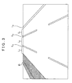
Fig. 3 is a drawing that shows an example of an image that is acquired by a camera; -
Fig. 4 is a flowchart for road information generating process; -
Fig. 5 is a flowchart for guidance process; and -
Fig. 6 is a drawing that shows the state in which a host vehicle that is traveling along a road is viewed from above. - Here, the embodiments of the present invention will be explained in the following order:
- (1) the structure of the navigation apparatus,
- (2) the road information generating process,
- (3) the guidance process, and
- (4) alternative embodiments.
-
FIG. 1 is a block diagram that shows the structure of anavigation apparatus 10, which includes the road information generating apparatus according to the present invention. Thenavigation apparatus 10 is provided with acontrol unit 20 that is provided with CPU, RAM, and ROM and the like, and astorage medium 30. It is possible to execute programs that are stored on thestorage medium 30 and the ROM by using thecontrol unit 20. In the present embodiment, anavigation program 21 can be executed as one of these programs, and thenavigation program 21 is provided, as one of the functions thereof, with a function that registers lane information that indicates the positions of each of the lanes and the relationships between each of the lanes and a function that carries out guidance based on this lane information. - In a host vehicle (a vehicle on which the
navigation apparatus 10 is mounted), aGPS receiving unit 40, avehicle speed sensor 41, agyroscopic sensor 42, acamera 43, adisplay unit 44, and aspeaker 45 are provided in order to realize the functions that are carried out by thenavigation program 21, and the transfer of signals between each of these units and thecontrol unit 20 is realized by an interface (not illustrated). - The
GPS receiving unit 40 receives radio waves from GPS satellites and outputs information for calculating a current position of the host vehicle via an interface (not illustrated). Thecontrol unit 20 acquires this signal, and thereby acquires the current position of the host vehicle. Thevehicle speed sensor 41 outputs signals that correspond to the rotational speed of the wheels that are provided on the host vehicle. Thecontrol unit 20 acquires this signal via an interface (not illustrated), and thereby acquires the speed of the vehicle. Thegyroscopic sensor 42 outputs a signal that corresponds to the direction of the host vehicle. Thecontrol unit 20 acquires this signal via an interface (not illustrated), and thereby acquires the travel direction of the host vehicle. Thevehicle speed sensor 41 and thegyroscopic sensor 42 are used in order to compensate the current position of the host vehicle that has been specified based on the output signal of theGPS receiving unit 40. In addition, the current position of the host vehicle is appropriately compensated based on the travel path of this host vehicle. - The
camera 43 photographs an image of the vicinity of the host vehicle and outputs image information that includes the road along which the host vehicle is traveling. Thecontrol unit 20 acquires this signal via an interface (not illustrated), and thereby acquires image information of an image that includes the road along which the vehicle is traveling.FIG. 2 is a drawing that shows the state in which a host vehicle C, which is traveling along the road, is viewed from above, and as shown in the present embodiment, thecamera 43 is a rear-view camera that is installed on the back portion of the host vehicle C. The field of view of thiscamera 43 is the road surface in back of the host vehicle C, which is shown by the broken lines. Note that provided that thecamera 43 can photograph an image that includes the road on which the host vehicle is traveling, thecamera 43 may be a front camera that can photograph the road surface in front of the host vehicle, or a camera that photographs the road surface at the side of the host vehicle. - In the present embodiment, the
navigation apparatus 10 is made to function as the road information generating apparatus according to the present invention by thenavigation program 21 carrying out the registration process for lane information. Thus, thenavigation program 21 is provided with a host vehicle positioninformation acquiring unit 21a, an image information acquiring unit 201 b, a host vehicle travellane detecting unit 21 c, and a laneinformation registering unit 21d. In addition, aguidance process unit 21e is provided in order to execute the guidance that uses this lane information. - In addition,
map information 30a for executing the guidance by thenavigation program 21 is stored on thestorage medium 30. Themap information 30a includes, for example, node data that indicates the nodes that are set on the road and contour interpolation point data for specifying the shape of a road between nodes, link data that indicates the links between nodes and contour interpolation points, and data that indicates landmarks. Themap information 30a is used in the specification of the current position of the host vehicle, guidance to a destination point, and compensating the host vehicle position (map matching) based on the travel path of the host vehicle. - In the present embodiment, the node data and the contour interpolation point data include data that indicates the position on the road, and the node data and the contour interpolation point data are generated for each of the lanes and registered. Furthermore, in the present embodiment, each of the nodes and each of the contour interpolation points are structured such that the relationships between each of the lanes can be grasped. For example, for each node and each contour interpolation point, a structure can be used in which the number of lanes in each road is associated with information that indicates that a lane is the nth lane (where n is a natural number) when counting from the left side toward the right side of the road. Note that the node data and the contour interpolation point data in the present embodiment are included in the
map information 30a, but because they are sets of information that are associated with a lane, they are also referred to aslane information 30b. - The host vehicle position
information acquiring unit 21 a is a module that acquires the host vehicle position information, which indicates the position of the host vehicle. It acquires the output signals of theGPS receiving unit 40, thevehicle speed sensor 41, and thegyroscopic sensor 42, and detects the longitude and latitude of the current position of the host vehicle, and the result is used as the host vehicle position information. The imageinformation acquiring unit 21b is a module that acquires the image information that is output by thecamera 43, and the acquired image information is received by the host vehicle travellane detecting unit 21 c. - The host vehicle travel
lane detecting unit 21c is a module that detects the host vehicle travel lane along which the host vehicle is traveling based on the image information. In the present embodiment, it extracts the image of the boundaries of the lanes. Specifically, on a road, features that correspond to the boundaries of the lanes (for example, road markings and structures) are present, and thus it is possible to specify the lane based on the image information if the image of this feature is extracted and then a characteristic quantity that corresponds to the boundaries of the lanes is extracted. Thus, the host vehicle travellane detecting unit 21c detects the host vehicle travel lane by specifying the relationships between the host vehicle C and each of the lanes based on the position of thecamera 43 and each of the lanes in the image. - For example, the boundaries of lanes L1, L2, and L3 in the road that is shown in
FIG. 2 are structured by white lines L4, L5, and L6, which are road markings, and a center divider D, which is a structure. When this road is photographed by thecamera 43 of the host vehicle C, an image such as that shown inFIG. 3 is obtained. Because the white lines L4, L5, and L6, and the center divider D extend along the road, in the image that is shown inFIG. 3 , an image that shows the white lines L4, L5, and L6, and the center divider D is extracted, and if the edges thereof are specified, it is possible to treat these edges as the boundaries of the lanes. Note that the extraction of the image that shows the white lines L4, L5, and L6 and the center divider D, and the specification of the edges can use well-known methods (for example, pattern matching and edge extraction, and Hough transform and the like). - Furthermore, the installation position of the
camera 43 in the host vehicle C is a position that has been determined in advance, and thus it is possible to associate figures at each of the positions in the image that has been photographed by thecamera 43 and the actual position of the feature that is present in the vicinity of the host vehicle C. For example, it is possible to specify that a portion that is present at the center of the image is a feature that is present in the vicinity of the center of the host vehicle, and a portion that is present on the right side of the image is a feature that is present on the left rear side of the host vehicle. Furthermore, in the example that is shown inFIG. 3 , it can be specified that the figure of the center divider D is present on the right rear side of the host vehicle and that the white line L4, which is continuous, is present on the left rear side of the host vehicle C. Thus, based on the image that is shown inFIG. 3 , it is possible to specify that there are three lanes. Therefore, when the lanes are set to L1, L2, and L3 in order from the left, it is possible to detect that the host vehicle travel lane is L2. - The lane
information registering unit 21 d generates the node data or the contour interpolation point data that shows the position of the host vehicle travel lane that has been specified as explained above based on the host vehicle position information that has been described above, and registers this information on thestorage medium 30 as thelane information 30b. Note that in the present embodiment, thelane information 30b is generated by setting the center position of the lane in the transverse direction to the position of a node or a contour interpolation point (which will be explained below in detail). In addition, in the present embodiment, it is possible to grasp the relationships between each of the lanes from the image information as has been described above, and thus thelane information 30b is generated such that these relationships can be understood. - The
guidance process unit 21e executes a guidance process by referring to thelane information 30b. Specifically, the host vehicle travel lane and the lanes in the vicinity thereof are identified by acquiring thelane information 30b, and the content of the guidance is specified based on the results of this identification. In addition, data for outputting the content of the guidance is output to thedisplay unit 44 and thespeaker 45. The content of the guidance is displayed in thedisplay unit 44 and the content of the guidance is output from thespeaker 45. As a result, the driver who is driving the host vehicle C can appropriately carry out driving based on guidance that reflects the differences in the lanes. - Next, road information generating process that is executed by the
navigation apparatus 10 in the above structure will be explained. When thenavigation program 21 is executed by thenavigation apparatus 10 while the host vehicle is traveling, the road information generating process that is shown inFIG. 4 is repeatedly executed at a constant interval (for example, 100 ms). - In this process, first, the host vehicle
information acquiring unit 21a acquires the host vehicle position information by acquiring the output signals of theGPS receiving unit 40, thevehicle speed sensor 41, and the gyroscopic sensor 42 (step S100). Next, the laneinformation registering unit 21d determines whether or not the lane information of the lane that corresponds to the position of the host vehicle has already been registered (step S105). In the present embodiment, because the map matching process described above is carried out in thenavigation program 21, in the case in which the position of the host vehicle which is indicated by the host vehicle position information is not matched in the map matching process, it is determined that the lane information has not yet been registered. - Specifically, map matching is a process that evaluates the host vehicle to be traveling along the road that is indicated by nodes and contour interpolation points when the travel path of the host vehicle conforms to the arrangement of the nodes and the contour interpolation points, and the nodes and contour interpolation points are necessary in order to carry out matching. Thus, in the present embodiment, the case in which there is no matching is evaluated as a case in which the nodes and contour interpolation points have not been registered yet. In addition, in step S105, when it has been determined that the lane information for the lane that corresponds to the position of the host vehicle has been registered, the process skips to step S110 and after because it is not necessary to generate lane information.
- In contrast, in step S105, when it has not been determined that the lane information of the lane that corresponds to the position of the host vehicle has been registered, in step S110 and after, a process is carried out in which the lane information is generated and registered on the
storage medium 30. In this process, first, the imageinformation acquiring unit 21b acquires image information from the camera 43 (step S110), and the host vehicle travellane detecting unit 21c carries out image recognition (step S115). Specifically, based on the image information, the host vehicle travellane detecting unit 21c carries out the process that detects the image of a feature that corresponds to the boundaries of the lanes, and detects the host vehicle travel lane and the other lanes. - Next, the host vehicle travel
lane detecting unit 21c determines whether or not the host vehicle travel lane and the other lanes can be specified (step S120). Specifically, in the image recognition, there are cases in which the host vehicle travel lane and the other lanes cannot be specified due to the influence of the weather and other vehicles or the like. In such a case, it is not possible to determine the relationships between the host vehicle travel lane and the other lanes accurately, and thus, when it has not been determined in step S120 that the lane can be specified, the process skips to the process of step S125 and after, and the process that generates lane information is not carried out. - In contrast, when it has been determined in step S120 that the host vehicle travel lane and the other lanes can be specified, the lane
information registering unit 21d carries out a process in which the center position of the host vehicle travel lane in the transverse direction is set to the position of the host vehicle travel lane based on the image information. In order to do this, first, it is determined whether or not the vehicle is traveling along the substantial center (including the center) of the host vehicle travel lane in the transverse direction (step S125). Specifically, because thecamera 43 is secured to the host vehicle, in the present embodiment, it is possible to specify in advance which position corresponds to a specified position in the image that has been acquired by thecamera 43 when viewed from the host vehicle. Therefore, if the host vehicle travel lane is detected based on the image information, it is possible to specify the relationship between the host vehicle travel lane and the host vehicle, and to determine whether or not the host vehicle is traveling along the substantial center of the host vehicle travel lane in the transverse direction. - For example, when the
camera 43 is secured to the center of the vehicle in the transverse direction such that the optical axis of thecamera 43 faces toward the rear of the vehicle, the center in the left to right direction of the image that has been taken by thecamera 43 matches the center of the host vehicle in the transverse direction. The image that is shown inFIG. 3 shows this example, and because the position of the center of the image in the left to right direction matches the center of the host vehicle in the transverse direction, it is possible to specify whether the host vehicle is traveling at the center of the host vehicle travel lane in the transverse direction depending on whether the position of the center in the image in the left to right direction and the center point of two boundaries that surround the position of this center substantially match. - In step S125, when it has been determined that the host vehicle is traveling along the center of the host vehicle travel lane in the transverse direction, the lane
information registering unit 21d acquires the host vehicle position information, generates lane information by setting the position of the host vehicle to the position of a node or a contour interpolation point, and registers the lane information on the storage medium 30 (step S130). Specifically, in the present embodiment, because the substantial center position of the lane in the transverse direction should be registered as the position of a node or a contour interpolation point, in the case in which the host vehicle is traveling along the substantial center of the host vehicle travel lane in the transverse direction, the position of the host vehicle is set to the position of the host vehicle travel lane. According to the structure, it is possible to specify the position of the host vehicle travel lane extremely easily. - In step S125, when it has not been determined that the host vehicle is traveling along the center of the host vehicle travel lane in the transverse direction, the lane
information registering unit 21d acquires the host vehicle position information, specifies the center position of the lane in the transverse direction by compensating the position that is shown by the host vehicle position information, generates lane information by setting the center position to the position of the node or a contour interpolation point, and registers the lane information on the storage medium 30 (step S135). Specifically, in order to compensate for the deviations of the host vehicle when the host vehicle is not traveling along the center of the host vehicle travel lane in the transverse direction, first, the center position of the host vehicle travel lane between the boundaries is detected based on the image that has been acquired by thecamera 43. - In addition, if the center position between the boundaries and the center position of the image in the left to right direction (that is, the center position of the vehicle in the transverse direction) are acquired, it is possible to specify the deviation between the center position of the lane in the transverse direction and the position of the host vehicle based on these center positions. Therefore, if the quantity of the deviation is increased or decreased with respect to the position of the host vehicle (that is, if the position is compensated in the direction parallel to the transverse direction), it is possible to specify the center position of the lane in the transverse direction based on the position of the host vehicle. Thus, when the center position of the lane in the transverse direction is specified, lane information is generated by using this position as the position of a node or a contour interpolation point, and the lane information is registered on the
storage medium 30. Note that the white circles that are shown inFIG. 2 indicate the position of a node or a contour interpolation point in the lane information that is generated in step S130 or step S135, and this node or the contour interpolation point is registered at a discreet position that has been determined in advance. - Note that in the above process, the substantial center position of the lane in the transverse direction may be determined in advance as a position in a range in which the position of the host vehicle being can be treated as the center of the lane in the transverse direction. In addition, when generating lane information in steps S130 and S135, as has been explained above, lane information is generated such that the relationships between the host vehicle travel lane and the other lanes can be grasped. Specifically, the lane
information registering unit 21d detects the boundaries of the host vehicle travel lane and the other lanes based on the image information, and specifies the arrangement of each lane that is specified based on the boundaries. Next, for a node or a contour interpolation point, the number of lanes in the road is associated with information that indicates that the host vehicle travel lane is the nth (where n is a natural number) lane when counting from the left side to the right side of the road. - As has been described above, in the present embodiment, a road is photographed by the
camera 43, and while specifying the appearance of the actual lane, the host vehicle travel lane and the other lanes are detected, and the positions thereof are registered as the positions of nodes or contour interpolation points. Therefore, it is possible to register the position of lanes accurately while clearly determining the relationships between the lanes. - Next, the guidance process that is carried out by the
navigation apparatus 10 in the structure that has been described above will be explained. When thenavigation program 21 is executed by thenavigation apparatus 10 while the host vehicle is traveling, theguidance process unit 21e repeatedly carries out the guidance process at constant intervals (for example, 100 ms). -
FIG. 5 shows the process when guidance is carried out before an intersection has been reached while the host vehicle is guided along a road that has been set in advance. In this process, first, theguidance process unit 21e acquires the host vehicle position information (step S200). Specifically, the host vehicle position information that has been acquired by the host vehicle position information requiring unit 201a is received, and the position of the host vehicle is specified. - Next, the
guidance process unit 21e determines whether or not a lane that corresponds to the position of the host vehicle is present (step S205). Specifically, thelane information 30b is referenced, and it is determined whether or not nodes or contour interpolation points are present that are characterized in that the link for the nodes and the contour interpolation points that are present in the vicinity of the position of the host vehicle substantially match the position of the host vehicle. In step S205, if it is not determined that a lane that corresponds to the position of the host vehicle is present, a guidance process is carried out without using the lane information that indicates the nodes or the contour interpolation points for each lane (step S230). - Specifically, even in a state in which the process that is shown in
FIG. 4 is not carried out, themap information 30a is registered in a state in which the lanes are not distinguished in the information that indicates the nodes and the contour interpolation points in each of the roads. Thus, guidance is carried out based on nodes and contour interpolation points for which the lanes are not distinguished. - In contrast, in step S205, when it has been determined that there is a lane that corresponds to the position of the host vehicle, it is determined whether or not it is possible to specify the host vehicle travel lane along which the host vehicle is traveling based on the host vehicle position information (step S210). Here as well, in the matching process that has been described above, it is determined whether or not the arrangement of the nodes and contour interpolation points that have been registered in the
lane information 30b and the travel path of the host vehicle conform, and the case in which they conform is evaluated as the case in which it is possible to specify the host vehicle travel lane along which the host vehicle is traveling. In step S210, if it is not determined that it is possible to specify the host vehicle travel lane, a guidance process is carried out in which the lane information that indicates the nodes and contour interpolation points of each of the lanes is not used (step S230). - When it has been determined in step S210 that it is possible to specify the host vehicle travel lane along which the host vehicle is traveling, it is further determined whether or not the host vehicle is approaching an intersection that is the object of guidance (step S215). Specifically, the
guidance process unit 21e refers to the host vehicle position information and themap information 30a, acquires the position of the intersection based on the node of the intersection that is the object of guidance, and based on the position of the intersection and the position of the host vehicle, determines whether or not the distance between the intersection and the host vehicle is equal to or less than a predetermined distance (for example, several hundred meters). When it has not been determined in step S215 that the host vehicle is approaching the intersection that is the object of guidance, it is not necessary to carry out guidance for the intersection at this point in time, and thus, step S220 and step S225 are skipped. - When it has been determined in step S215 that the host vehicle is approaching an intersection that is the object of guidance, the
guidance process unit 21e carries out lane guidance (step S220). Specifically, because a planned route for the host vehicle at the intersection that is the object of guidance is specified, at the intersection that is the object of guidance, it is possible to specify whether it is planned that the vehicle will either execute a right or left turn or travel forward. Thus, in order to carry out guidance such that the host vehicle moves to a lane that is advantageous for executing either a left or right turn or traveling forward, theguidance process unit 21e outputs control information for carrying out guidance to thedisplay unit 44 and thespeaker 45. As a result, it is possible for the host vehicle to move to a lane that is advantageous for executing either a right or left turn or traveling forward at the intersection, and it is possible to carry out the desired operation easily at the intersection. Note that when it is determined in step S225 that the host vehicle has passed through the intersection that is the object of guidance, theguidance process unit 21e ends the above guidance process. -
FIG. 6 shows a road that is similar to the road that is shown inFIG. 2 , and below, an operating example of a case in which the host vehicle should make a right turn at an intersection I on this road will be explained. InFIG. 6 , the contour interpolation points are indicated by white circles and the nodes are indicated by black circles, and a state is assumed in which the lane information that indicates the nodes and the contour interpolation points related to the lanes L1, L2, and L3 of the road along which the host vehicle C is traveling have been registered on thestorage medium 30. - In this state, when the
guidance process unit 21e carries out route guidance, because the nodes and the contour interpolation points conform to the path of the host vehicle, in the process that is shown inFIG. 5 , after passing through step S200 to step S205, it is determined that a lane that corresponds to the position of the host vehicle is present, and in step S210, it is determined that it is possible to specify the host vehicle travel lane. In addition, in step S215, it is determined that the host vehicle C is approaching the intersection I. - Therefore, in step S220, lane guidance is carried out based on the lane information for the host vehicle travel lane. In the example that is shown in
FIG. 6 , the host vehicle C is traveling along the leftmost lane L1, and it is necessary for the host vehicle to travel along the rightmost lane L3 in order to make a right turn at the intersection I. Thus, in the guidance of step S220, in order to carry out guidance such that the host vehicle C will be traveling along the lane L3 before entering the intersection I, a control signal for outputting, for example, the audio: "Turn right soon. Please move two lanes to the right." is output to thespeaker 45. As a result, the driver can recognize that it is necessary to change lanes twice in order to travel according to the travel plan, and it is possible to carry out the lane changes such that preparations can easily be carried out before the host vehicle enters the intersection I. - The above embodiment is one example for implementing the present invention, and provided that it is possible to detect the host vehicle travel lane based on image information and that it is possible to generate lane information that indicates the position thereof, various alternative embodiments can be used. For example, in addition to a structure in which the host vehicle position information uses all of the
GPS receiving unit 40, thevehicle speed sensor 41, and thegyroscopic sensor 42, the host vehicle position information may also be structured so as to use only a portion of these, or the host vehicle position information may also be acquired based on image information that has been acquired by a camera. In addition, it is possible to use a structure in which the host vehicle position information is acquired by inter-vehicle communication or road-to-vehicle communication or the like. - Furthermore, in addition to a structure in which the host vehicle travel lane is detected based on an image that has been photographed by a camera that is mounted on the host vehicle, a structure may also be used in which the host vehicle travel lane is acquired by photographing the vicinity of the host vehicle by using a camera or the like that is mounted in the road surface. Furthermore, when detecting the lane based on image information, provided that it is possible to detect the host vehicle travel lane along which the host vehicle is traveling from among a plurality of or a single lane based on image information, the lane may also be detected by using the road shoulder, road markings in the lane and structures and the like, in addition to the lines that indicate the boundaries of the lanes and center divider.
- Furthermore, when registering the position of the lane as lane information, registering the center position of the lane in the transverse direction is preferable because the results can be directly used in map matching or the like. However, in terms of specifying a lane, it is also possible to register a position besides the center position of the lane in the transverse direction as the position of the lane. For example, the position of the host vehicle travel lane may also be specified by a reference position in the lane (for example, an endpoint in the lane in the transverse direction).
- Furthermore, the mode of the use of the lane information in which the position of each lane has been registered is not limited to the guidance that has been described above. For example, if the lane along which the host vehicle was traveling is specified by map matching or the like, it is possible to specify accurately the lane along which the host vehicle is traveling. If the position along which the vehicle is traveling in the lane is specified accurately, it is possible to carry out accurate guidance based on the position of the host vehicle. In addition, even for a host vehicle that is traveling along the same road, it is possible to carry out guidance that differs for each lane, and it is possible to provide guidance about traffic congestion information that differs for each lane.
- Furthermore, by setting contour interpolation points for each lane, it is possible to carry out vehicle control according to a curve contour that differs for each lane. For example, in a structure in which the direction of the optical axis of the headlights of the host vehicle changes depending on the curve contour, it is possible to use a structure in which the direction of the optical axis is changed by an angle that differs for each lane depending on the radius of curvature of a curve that differs for each lane.
- Furthermore, the mode of information that indicates the relationships between the host vehicle travel lane and the other lanes, which is registered in the lane information, is only required to be structured to be able to specify the direction of another lane when viewed from the host vehicle travel lane based on at least this information. Therefore, for example, when the position of the host vehicle travel lane is registered, a structure can be used that specifies the presence or absence of another lane on the left or right of the host vehicle travel lane, that specifies the order of the host vehicle travel lane (for example, information that indicates which number the lane is when counted from the leftmost lane), and specifies the relative position (left lane, center lane, right lane, or the like) at which the host vehicle travel lane is present. Of course, the lane information is generated as information that indicates the relationships between the host vehicle travel lane and the other lanes when the lane information is generated, but at the stage that uses the lane information, the lane information is only required to be able to specify the relationships between the lanes irrespective of whether or not a lane is the host vehicle travel lane.
- Furthermore, as a structure for determining whether or not lane information for a lane that corresponds to the position of the host vehicle has been registered is not limited to a determination based on the success or failure of the matching process. Specifically, here, in the case in which the lane information for the host vehicle travel lane is not registered yet on the storage medium, provided that the lane information for the host vehicle travel lane can be generated and registered, a structure may be used in which it is determined whether or not the lane information for vicinity of the host vehicle position has been registered. In such a structure, it is possible to save resources because there is no excess registering of the same information and redundant execution of processes that generate the same lane information.
- Note that the registering of lane information for a certain lane may be completed at the point in time at which lane information is generated one time for each lane, or may be completed after being generated a plurality of times. Specifically, it is possible to use a structure in which lane information for a certain lane is generated a plurality of times, lane information is determined by acquiring and registering statistical values (mean values or the like) for this information, and registered. According to this structure, it is possible to generate and register more accurate lane information.
It is explicitly stated that all features disclosed in the description and/or the claims are intended to be disclosed separately and independently from each other for the purpose of original disclosure as well as for the purpose of restricting the claimed invention independent of the composition of the features in the embodiments and/or the claims. It is explicitly stated that all value ranges or indications of groups of entities disclose every possible intermediate value or intermediate entity for the purpose of original disclosure as well as for the purpose of restricting the claimed invention, in particular as limits of value ranges.
Claims (5)
- A road information generating apparatus, comprising:a host vehicle position information acquiring unit (21a) adapted for acquiring host vehicle position information that indicates a position of a host vehicle (c);an image information acquiring unit (21b) adapted for acquiring image information that includes a road along which the host vehicle (c) is traveling;a host vehicle travel lane detecting unit (21c) adapted for detecting a host vehicle travel lane along which the host vehicle (c) is traveling based on the image information; anda lane information registering unit (21d) adapted for determining whether or not lane information that indicates a position of the host vehicle travel is registered on a storage medium (30), and in the case in which the lane information is not registered, for generating lane information that indicates the position of the host vehicle travel lane based on the host vehicle position information, and for registering the lane information on the storage medium (30).
- The road information generating apparatus according to claim 1, wherein
the host vehicle travel lane detecting unit (21c) is adapted for detecting the host vehicle travel lane and other lane by extracting an image of a boundary of the lanes based on the image information, and
the lane information registering unit (21d) generates lane information that indicates the position of the host vehicle travel lane and the relationships between the host vehicle travel lane and the other lane. - The road information generating apparatus according to claim 1 or claim 2, wherein
the lane information registering unit (21d) is adapted for acquiring a center position of the host vehicle travel lane in a transverse direction based on the image information, and for setting the center position to the position of the host vehicle travel lane. - A road information generating method, comprising the steps of:acquiring (S100) host vehicle position information that indicates a position of a host vehicle (c);acquiring (S110) image information that includes a road along which the host vehicle (c) is traveling;detecting (S120) a host vehicle travel lane along which the host vehicle (c) is traveling based on the image information; anddetermining (S105) whether or not lane information that indicates a position of the host vehicle travel lane is registered on a storage medium (30), and in the case in which the lane information is not registered, generating (S130) lane information that indicates the position of the host vehicle travel lane based on the host vehicle position information, and registering (S130) the lane information on the storage medium (30).
- A road information generating program that, when executed on a computer, causes the computer to perform the steps of the method according to claim 4.
Applications Claiming Priority (1)
| Application Number | Priority Date | Filing Date | Title |
|---|---|---|---|
| JP2007177758A JP4506790B2 (en) | 2007-07-05 | 2007-07-05 | Road information generation apparatus, road information generation method, and road information generation program |
Publications (3)
| Publication Number | Publication Date |
|---|---|
| EP2012088A2 true EP2012088A2 (en) | 2009-01-07 |
| EP2012088A3 EP2012088A3 (en) | 2010-09-01 |
| EP2012088B1 EP2012088B1 (en) | 2015-05-06 |
Family
ID=39811803
Family Applications (1)
| Application Number | Title | Priority Date | Filing Date |
|---|---|---|---|
| EP20080011549 Not-in-force EP2012088B1 (en) | 2007-07-05 | 2008-06-25 | Road information generating apparatus, road information generating method and road information generating program |
Country Status (4)
| Country | Link |
|---|---|
| US (1) | US8209123B2 (en) |
| EP (1) | EP2012088B1 (en) |
| JP (1) | JP4506790B2 (en) |
| CN (1) | CN101339043B (en) |
Cited By (4)
| Publication number | Priority date | Publication date | Assignee | Title |
|---|---|---|---|---|
| EP2302323A3 (en) * | 2009-09-23 | 2011-06-01 | HTC Corporation | Method, system, and computer program product for navigating vehicle |
| WO2013113904A1 (en) * | 2012-02-03 | 2013-08-08 | Renault S.A.S. | Method of determining the positioning of a vehicle in a traffic corridor of a lane, and methods for detecting alignment and risk of collision between two vehicles |
| WO2015065678A1 (en) * | 2013-10-31 | 2015-05-07 | Toyota Motor Engineering & Manufacturing North America, Inc. | Method for generating accurate lane level maps |
| FR3082044A1 (en) * | 2018-05-31 | 2019-12-06 | Psa Automobiles Sa | METHOD AND DEVICE FOR DETECTING THE TRACK ON WHICH A VEHICLE IS MOVING, ACCORDING TO THE DETERMINED DETERMINATIONS |
Families Citing this family (44)
| Publication number | Priority date | Publication date | Assignee | Title |
|---|---|---|---|---|
| KR101552718B1 (en) * | 2008-07-18 | 2015-09-18 | 엘지전자 주식회사 | Device for guiding path and Method for input of execute command thereof |
| WO2010047580A1 (en) * | 2008-10-21 | 2010-04-29 | Telefonaktiebolaget Lm Ericsson (Publ) | Reporting of changes in navigation map data for navigation system |
| CN102006526B (en) | 2009-09-01 | 2016-01-20 | 中兴通讯股份有限公司 | A kind of broadcast packet/multicast controls message processing method and device |
| CN102235874A (en) * | 2010-04-28 | 2011-11-09 | 北京四维图新科技股份有限公司 | Method and device for automatically updating number of lanes in electronic map |
| DE102010033729B4 (en) * | 2010-08-07 | 2014-05-08 | Audi Ag | Method and device for determining the position of a vehicle on a roadway and motor vehicles with such a device |
| KR101231510B1 (en) * | 2010-10-11 | 2013-02-07 | 현대자동차주식회사 | System for alarming a danger coupled with driver-viewing direction, thereof method and vehicle for using the same |
| US20120109521A1 (en) * | 2010-10-27 | 2012-05-03 | Reagan Inventions, Llc | System and method of integrating lane position monitoring with locational information systems |
| DE102011010377A1 (en) * | 2011-02-04 | 2012-08-09 | GM Global Technology Operations LLC (n. d. Gesetzen des Staates Delaware) | Method for operating a motor vehicle and motor vehicle |
| JP5716443B2 (en) * | 2011-02-16 | 2015-05-13 | 日産自動車株式会社 | Lane boundary detection device and lane boundary detection method |
| KR20120113579A (en) * | 2011-04-05 | 2012-10-15 | 현대자동차주식회사 | Apparatus and method for displaying road guide information on the windshield |
| CN103052976B (en) * | 2011-06-08 | 2016-05-11 | 丰田自动车株式会社 | Track departs from servicing unit, dividing line display methods, the program of preventing |
| JP5708449B2 (en) * | 2011-11-08 | 2015-04-30 | アイシン・エィ・ダブリュ株式会社 | Lane guidance display system, method and program |
| CN104296761B (en) * | 2012-05-30 | 2017-04-19 | 常州市新科汽车电子有限公司 | Method for matching main and side roads by navigator with high real-time performance |
| CN105806352B (en) * | 2012-05-30 | 2018-09-07 | 常州市新科汽车电子有限公司 | The working method of based on camera, real-time and the higher navigator of accuracy |
| CN103954292B (en) * | 2012-05-30 | 2017-02-22 | 常州市新科汽车电子有限公司 | Navigator-based method for matching main road and side road of road according to traffic lane line |
| KR101957943B1 (en) * | 2012-08-31 | 2019-07-04 | 삼성전자주식회사 | Method and vehicle for providing information |
| EP2959266A4 (en) | 2013-02-25 | 2017-05-03 | Continental Automotive GmbH | Intelligent video navigation for automobiles |
| USD750663S1 (en) | 2013-03-12 | 2016-03-01 | Google Inc. | Display screen or a portion thereof with graphical user interface |
| US8676431B1 (en) | 2013-03-12 | 2014-03-18 | Google Inc. | User interface for displaying object-based indications in an autonomous driving system |
| USD754189S1 (en) * | 2013-03-13 | 2016-04-19 | Google Inc. | Display screen or portion thereof with graphical user interface |
| USD754190S1 (en) * | 2013-03-13 | 2016-04-19 | Google Inc. | Display screen or portion thereof with graphical user interface |
| CN104118352B (en) * | 2013-04-29 | 2016-12-28 | 青岛玉兰祥商务服务有限公司 | Vehicle assisted system, vehicle auxiliary method and vehicle |
| CN104422462A (en) * | 2013-09-06 | 2015-03-18 | 上海博泰悦臻电子设备制造有限公司 | Vehicle navigation method and vehicle navigation device |
| KR20150043780A (en) * | 2013-10-15 | 2015-04-23 | 한국전자통신연구원 | Navigation apparatus having lane guidance function and method for performing the same |
| CN107533801A (en) | 2013-11-01 | 2018-01-02 | 国际智能技术公司 | Use the ground mapping technology of mapping vehicle |
| KR20150068218A (en) * | 2013-12-11 | 2015-06-19 | 경북대학교 산학협력단 | Vehicular Navigation System |
| US10068472B2 (en) * | 2014-06-06 | 2018-09-04 | Veoneer Us, Inc. | Automotive lane discipline system, method, and apparatus |
| US9170116B1 (en) * | 2014-07-11 | 2015-10-27 | Toyota Motor Engineering & Manufacturing North America, Inc. | Method for generating accurate lane level maps |
| DE102014220199B3 (en) * | 2014-10-06 | 2016-01-14 | Continental Automotive Gmbh | Method for a motor vehicle with a camera, device and system |
| JP6469220B2 (en) * | 2015-06-15 | 2019-02-13 | 三菱電機株式会社 | Traveling lane discrimination device and traveling lane discrimination method |
| US10503983B2 (en) * | 2015-08-19 | 2019-12-10 | Mitsubishi Electric Corporation | Lane recognition apparatus and lane recognition method |
| CN108303103B (en) | 2017-02-07 | 2020-02-07 | 腾讯科技(深圳)有限公司 | Method and device for determining target lane |
| EP3473980B1 (en) * | 2017-07-06 | 2022-05-04 | UISEE (Shanghai) Automotive Technologies Ltd. | Road characterization method, and method and device for displaying road information |
| BR112020002623A2 (en) * | 2017-08-10 | 2020-07-28 | Nissan Motor Co., Ltd. | traffic lane information management method, displacement control method and traffic lane information management device |
| JP6583697B2 (en) * | 2017-09-26 | 2019-10-02 | 本田技研工業株式会社 | Perimeter monitoring device, control device, perimeter monitoring method, and program |
| KR102421855B1 (en) * | 2017-09-28 | 2022-07-18 | 삼성전자주식회사 | Method and apparatus of identifying driving lane |
| CN107907138A (en) * | 2017-11-15 | 2018-04-13 | 宁波麦度智联科技股份有限公司 | A kind of application method of mobile terminal road turning prompt system |
| CN108377599B (en) * | 2018-04-27 | 2020-04-14 | 北京新能源汽车股份有限公司 | Vehicle and lighting system thereof |
| KR102483649B1 (en) | 2018-10-16 | 2023-01-02 | 삼성전자주식회사 | Vehicle localization method and vehicle localization apparatus |
| CN109979204A (en) * | 2019-04-02 | 2019-07-05 | 浙江多普勒环保科技有限公司 | Light cuts multilane speed and acceleration detecting and its method |
| DE102019003238B4 (en) * | 2019-05-08 | 2023-04-20 | Mercedes-Benz Group AG | Vehicle location by map comparison taking into account a street profile |
| CN111523471B (en) * | 2020-04-23 | 2023-08-04 | 阿波罗智联(北京)科技有限公司 | Method, device, equipment and storage medium for determining lane where vehicle is located |
| KR20220028709A (en) * | 2020-08-31 | 2022-03-08 | 현대모비스 주식회사 | Driving control method and system for vehicles |
| CN114894205B (en) * | 2022-05-18 | 2023-05-23 | 禾多科技(北京)有限公司 | Three-dimensional lane line information generation method, device, equipment and computer readable medium |
Citations (3)
| Publication number | Priority date | Publication date | Assignee | Title |
|---|---|---|---|---|
| US5922036A (en) | 1996-05-28 | 1999-07-13 | Matsushita Electric Industrial Co., Ltd. | Lane detection sensor and navigation system employing the same |
| US6526352B1 (en) | 2001-07-19 | 2003-02-25 | Intelligent Technologies International, Inc. | Method and arrangement for mapping a road |
| US6577334B1 (en) | 1998-02-18 | 2003-06-10 | Kabushikikaisha Equos Research | Vehicle control |
Family Cites Families (15)
| Publication number | Priority date | Publication date | Assignee | Title |
|---|---|---|---|---|
| JP2000230834A (en) * | 1999-02-10 | 2000-08-22 | Daihatsu Motor Co Ltd | Updating equipment of road map information and its control method |
| US6385539B1 (en) | 1999-08-13 | 2002-05-07 | Daimlerchrysler Ag | Method and system for autonomously developing or augmenting geographical databases by mining uncoordinated probe data |
| JP2001289654A (en) | 2000-04-11 | 2001-10-19 | Equos Research Co Ltd | Navigator, method of controlling navigator and memory medium having recorded programs |
| JP4016735B2 (en) | 2001-11-30 | 2007-12-05 | 株式会社日立製作所 | Lane mark recognition method |
| DE10345802A1 (en) * | 2003-09-30 | 2005-04-14 | Robert Bosch Gmbh | Driving lane recognizing method e.g. for vehicle, involves equipping adaptive spacer and speed control which are governed by object detection system and detects relative velocity of objects |
| JP2004251790A (en) * | 2003-02-20 | 2004-09-09 | Denso Corp | Navigation system for vehicle |
| JP3864945B2 (en) * | 2003-09-24 | 2007-01-10 | アイシン精機株式会社 | Road lane detection device |
| JP4075800B2 (en) * | 2003-12-26 | 2008-04-16 | トヨタ自動車株式会社 | White line detector |
| US7363151B2 (en) | 2004-06-21 | 2008-04-22 | Matsushita Electric Industrial Co., Ltd. | Map error information obtaining system and map error information obtaining method |
| DE102004038734A1 (en) * | 2004-08-10 | 2006-02-23 | Robert Bosch Gmbh | Method and device for triggering emergency braking |
| JP2006189325A (en) | 2005-01-06 | 2006-07-20 | Aisin Aw Co Ltd | Present location information management device of vehicle |
| JP4822099B2 (en) * | 2005-07-11 | 2011-11-24 | アイシン・エィ・ダブリュ株式会社 | Navigation device and navigation method |
| KR100716893B1 (en) * | 2005-07-26 | 2007-05-09 | 주식회사 현대오토넷 | Apparatus and method for registrating a non-registration road in a car navigation system |
| JP4420011B2 (en) * | 2006-11-16 | 2010-02-24 | 株式会社日立製作所 | Object detection device |
| US8200424B2 (en) * | 2008-10-17 | 2012-06-12 | Mitsubishi Electric Corporation | Navigation device |
-
2007
- 2007-07-05 JP JP2007177758A patent/JP4506790B2/en not_active Expired - Fee Related
-
2008
- 2008-05-15 CN CN2008100995777A patent/CN101339043B/en active Active
- 2008-06-24 US US12/213,722 patent/US8209123B2/en active Active
- 2008-06-25 EP EP20080011549 patent/EP2012088B1/en not_active Not-in-force
Patent Citations (3)
| Publication number | Priority date | Publication date | Assignee | Title |
|---|---|---|---|---|
| US5922036A (en) | 1996-05-28 | 1999-07-13 | Matsushita Electric Industrial Co., Ltd. | Lane detection sensor and navigation system employing the same |
| US6577334B1 (en) | 1998-02-18 | 2003-06-10 | Kabushikikaisha Equos Research | Vehicle control |
| US6526352B1 (en) | 2001-07-19 | 2003-02-25 | Intelligent Technologies International, Inc. | Method and arrangement for mapping a road |
Cited By (8)
| Publication number | Priority date | Publication date | Assignee | Title |
|---|---|---|---|---|
| EP2302323A3 (en) * | 2009-09-23 | 2011-06-01 | HTC Corporation | Method, system, and computer program product for navigating vehicle |
| US8532917B2 (en) | 2009-09-23 | 2013-09-10 | Htc Corporation | Method, system, and recording medium for navigating vehicle |
| WO2013113904A1 (en) * | 2012-02-03 | 2013-08-08 | Renault S.A.S. | Method of determining the positioning of a vehicle in a traffic corridor of a lane, and methods for detecting alignment and risk of collision between two vehicles |
| FR2986646A1 (en) * | 2012-02-03 | 2013-08-09 | Renault Sas | METHOD FOR DETERMINING THE POSITIONING OF A VEHICLE IN A WAY CIRCULATION HALL, AND METHODS OF DETECTING ALIGNMENT AND RISK OF COLLISION BETWEEN TWO VEHICLES |
| US9711051B2 (en) | 2012-02-03 | 2017-07-18 | Renault S.A.S. | Method of determining the position of a vehicle in a traffic lane of a road and methods for detecting alignment and risk of collision between two vehicles |
| WO2015065678A1 (en) * | 2013-10-31 | 2015-05-07 | Toyota Motor Engineering & Manufacturing North America, Inc. | Method for generating accurate lane level maps |
| US9384394B2 (en) | 2013-10-31 | 2016-07-05 | Toyota Motor Engineering & Manufacturing North America, Inc. | Method for generating accurate lane level maps |
| FR3082044A1 (en) * | 2018-05-31 | 2019-12-06 | Psa Automobiles Sa | METHOD AND DEVICE FOR DETECTING THE TRACK ON WHICH A VEHICLE IS MOVING, ACCORDING TO THE DETERMINED DETERMINATIONS |
Also Published As
| Publication number | Publication date |
|---|---|
| JP2009014574A (en) | 2009-01-22 |
| EP2012088A3 (en) | 2010-09-01 |
| US20090012709A1 (en) | 2009-01-08 |
| CN101339043B (en) | 2012-09-26 |
| JP4506790B2 (en) | 2010-07-21 |
| US8209123B2 (en) | 2012-06-26 |
| EP2012088B1 (en) | 2015-05-06 |
| CN101339043A (en) | 2009-01-07 |
Similar Documents
| Publication | Publication Date | Title |
|---|---|---|
| EP2012088B1 (en) | Road information generating apparatus, road information generating method and road information generating program | |
| US10300916B2 (en) | Autonomous driving assistance system, autonomous driving assistance method, and computer program | |
| EP2065679B1 (en) | Navigation device, navigation method and navigation program | |
| CN107430819B (en) | Vehicle information processing device and vehicle information processing method | |
| US8433504B2 (en) | Traffic information generation method, traffic information generation device, and navigation system | |
| US8085984B2 (en) | Image recognizing apparatus and method, and position determining apparatus, vehicle controlling apparatus and navigation apparatus using the image recognizing apparatus or method | |
| EP1223407A1 (en) | Vehicle-mounted position computing apparatus | |
| CN109115231B (en) | Vehicle positioning method and device and automatic driving vehicle | |
| WO2014171073A1 (en) | Curve-shape modeling device, vehicle information processing system, curve-shape modeling method, and curve-shape modeling program | |
| CN111380539A (en) | Vehicle positioning and navigation method and device and related system | |
| CN108573611B (en) | Speed limit sign fusion method and speed limit sign fusion system | |
| US11719555B2 (en) | Map information system | |
| US20090018767A1 (en) | Method for determining the geometry of a route section | |
| CN109791698B (en) | Method, device and computer-readable storage medium with instructions for determining the lateral position of a vehicle relative to a lane of a road surface | |
| JPH09152348A (en) | Car navigation device | |
| US11333516B2 (en) | Lane guidance system and lane guidance program | |
| CN110164164A (en) | The method for identifying complicated road precision using camera shooting function enhancing Mobile Telephone Gps software | |
| CN112781600A (en) | Vehicle navigation method, device and storage medium | |
| CN112739599B (en) | Vehicle lane change behavior identification method and device | |
| US20230373526A1 (en) | Driving assistance control device and driving assistance control method | |
| CN115427760A (en) | Method and device for determining the position of a vehicle in a road network | |
| JP5549468B2 (en) | Feature position acquisition apparatus, method and program | |
| JP2013032954A (en) | Position determination device and navigation device, position determination method, and program | |
| JP2012137362A (en) | Travel road estimation device, method, and program | |
| JP2022007526A (en) | Surrounding vehicle discrimination system, and surrounding vehicle discrimination program |
Legal Events
| Date | Code | Title | Description |
|---|---|---|---|
| PUAI | Public reference made under article 153(3) epc to a published international application that has entered the european phase |
Free format text: ORIGINAL CODE: 0009012 |
|
| AK | Designated contracting states |
Kind code of ref document: A2 Designated state(s): AT BE BG CH CY CZ DE DK EE ES FI FR GB GR HR HU IE IS IT LI LT LU LV MC MT NL NO PL PT RO SE SI SK TR |
|
| AX | Request for extension of the european patent |
Extension state: AL BA MK RS |
|
| PUAL | Search report despatched |
Free format text: ORIGINAL CODE: 0009013 |
|
| AK | Designated contracting states |
Kind code of ref document: A3 Designated state(s): AT BE BG CH CY CZ DE DK EE ES FI FR GB GR HR HU IE IS IT LI LT LU LV MC MT NL NO PL PT RO SE SI SK TR |
|
| AX | Request for extension of the european patent |
Extension state: AL BA MK RS |
|
| RIC1 | Information provided on ipc code assigned before grant |
Ipc: G01C 21/26 20060101AFI20081017BHEP Ipc: G01C 21/32 20060101ALI20100728BHEP |
|
| 17P | Request for examination filed |
Effective date: 20110223 |
|
| AKX | Designation fees paid |
Designated state(s): AT BE BG CH CY CZ DE DK EE ES FI FR GB GR HR HU IE IS IT LI LT LU LV MC MT NL NO PL PT RO SE SI SK TR |
|
| 17Q | First examination report despatched |
Effective date: 20111229 |
|
| REG | Reference to a national code |
Ref country code: DE Ref legal event code: R079 Ref document number: 602008038003 Country of ref document: DE Free format text: PREVIOUS MAIN CLASS: G01C0021260000 Ipc: G01C0021360000 |
|
| GRAP | Despatch of communication of intention to grant a patent |
Free format text: ORIGINAL CODE: EPIDOSNIGR1 |
|
| RIC1 | Information provided on ipc code assigned before grant |
Ipc: G06T 7/00 20060101ALI20150108BHEP Ipc: G06K 9/00 20060101ALI20150108BHEP Ipc: G01C 21/36 20060101AFI20150108BHEP Ipc: G01C 21/32 20060101ALI20150108BHEP Ipc: G01C 21/26 20060101ALI20150108BHEP |
|
| INTG | Intention to grant announced |
Effective date: 20150123 |
|
| GRAS | Grant fee paid |
Free format text: ORIGINAL CODE: EPIDOSNIGR3 |
|
| GRAA | (expected) grant |
Free format text: ORIGINAL CODE: 0009210 |
|
| AK | Designated contracting states |
Kind code of ref document: B1 Designated state(s): AT BE BG CH CY CZ DE DK EE ES FI FR GB GR HR HU IE IS IT LI LT LU LV MC MT NL NO PL PT RO SE SI SK TR |
|
| REG | Reference to a national code |
Ref country code: GB Ref legal event code: FG4D |
|
| REG | Reference to a national code |
Ref country code: CH Ref legal event code: EP |
|
| REG | Reference to a national code |
Ref country code: IE Ref legal event code: FG4D |
|
| REG | Reference to a national code |
Ref country code: AT Ref legal event code: REF Ref document number: 726020 Country of ref document: AT Kind code of ref document: T Effective date: 20150615 |
|
| REG | Reference to a national code |
Ref country code: DE Ref legal event code: R096 Ref document number: 602008038003 Country of ref document: DE Effective date: 20150618 |
|
| REG | Reference to a national code |
Ref country code: AT Ref legal event code: MK05 Ref document number: 726020 Country of ref document: AT Kind code of ref document: T Effective date: 20150506 |
|
| REG | Reference to a national code |
Ref country code: NL Ref legal event code: MP Effective date: 20150506 |
|
| REG | Reference to a national code |
Ref country code: LT Ref legal event code: MG4D |
|
| PG25 | Lapsed in a contracting state [announced via postgrant information from national office to epo] |
Ref country code: FI Free format text: LAPSE BECAUSE OF FAILURE TO SUBMIT A TRANSLATION OF THE DESCRIPTION OR TO PAY THE FEE WITHIN THE PRESCRIBED TIME-LIMIT Effective date: 20150506 Ref country code: HR Free format text: LAPSE BECAUSE OF FAILURE TO SUBMIT A TRANSLATION OF THE DESCRIPTION OR TO PAY THE FEE WITHIN THE PRESCRIBED TIME-LIMIT Effective date: 20150506 Ref country code: ES Free format text: LAPSE BECAUSE OF FAILURE TO SUBMIT A TRANSLATION OF THE DESCRIPTION OR TO PAY THE FEE WITHIN THE PRESCRIBED TIME-LIMIT Effective date: 20150506 Ref country code: LT Free format text: LAPSE BECAUSE OF FAILURE TO SUBMIT A TRANSLATION OF THE DESCRIPTION OR TO PAY THE FEE WITHIN THE PRESCRIBED TIME-LIMIT Effective date: 20150506 Ref country code: PT Free format text: LAPSE BECAUSE OF FAILURE TO SUBMIT A TRANSLATION OF THE DESCRIPTION OR TO PAY THE FEE WITHIN THE PRESCRIBED TIME-LIMIT Effective date: 20150907 Ref country code: NO Free format text: LAPSE BECAUSE OF FAILURE TO SUBMIT A TRANSLATION OF THE DESCRIPTION OR TO PAY THE FEE WITHIN THE PRESCRIBED TIME-LIMIT Effective date: 20150806 |
|
| PG25 | Lapsed in a contracting state [announced via postgrant information from national office to epo] |
Ref country code: LV Free format text: LAPSE BECAUSE OF FAILURE TO SUBMIT A TRANSLATION OF THE DESCRIPTION OR TO PAY THE FEE WITHIN THE PRESCRIBED TIME-LIMIT Effective date: 20150506 Ref country code: GR Free format text: LAPSE BECAUSE OF FAILURE TO SUBMIT A TRANSLATION OF THE DESCRIPTION OR TO PAY THE FEE WITHIN THE PRESCRIBED TIME-LIMIT Effective date: 20150807 Ref country code: AT Free format text: LAPSE BECAUSE OF FAILURE TO SUBMIT A TRANSLATION OF THE DESCRIPTION OR TO PAY THE FEE WITHIN THE PRESCRIBED TIME-LIMIT Effective date: 20150506 Ref country code: BG Free format text: LAPSE BECAUSE OF FAILURE TO SUBMIT A TRANSLATION OF THE DESCRIPTION OR TO PAY THE FEE WITHIN THE PRESCRIBED TIME-LIMIT Effective date: 20150806 Ref country code: IS Free format text: LAPSE BECAUSE OF FAILURE TO SUBMIT A TRANSLATION OF THE DESCRIPTION OR TO PAY THE FEE WITHIN THE PRESCRIBED TIME-LIMIT Effective date: 20150906 |
|
| PG25 | Lapsed in a contracting state [announced via postgrant information from national office to epo] |
Ref country code: DK Free format text: LAPSE BECAUSE OF FAILURE TO SUBMIT A TRANSLATION OF THE DESCRIPTION OR TO PAY THE FEE WITHIN THE PRESCRIBED TIME-LIMIT Effective date: 20150506 Ref country code: EE Free format text: LAPSE BECAUSE OF FAILURE TO SUBMIT A TRANSLATION OF THE DESCRIPTION OR TO PAY THE FEE WITHIN THE PRESCRIBED TIME-LIMIT Effective date: 20150506 Ref country code: IT Free format text: LAPSE BECAUSE OF FAILURE TO SUBMIT A TRANSLATION OF THE DESCRIPTION OR TO PAY THE FEE WITHIN THE PRESCRIBED TIME-LIMIT Effective date: 20150506 |
|
| REG | Reference to a national code |
Ref country code: CH Ref legal event code: PL |
|
| REG | Reference to a national code |
Ref country code: DE Ref legal event code: R097 Ref document number: 602008038003 Country of ref document: DE |
|
| PG25 | Lapsed in a contracting state [announced via postgrant information from national office to epo] |
Ref country code: SK Free format text: LAPSE BECAUSE OF FAILURE TO SUBMIT A TRANSLATION OF THE DESCRIPTION OR TO PAY THE FEE WITHIN THE PRESCRIBED TIME-LIMIT Effective date: 20150506 Ref country code: RO Free format text: LAPSE BECAUSE OF NON-PAYMENT OF DUE FEES Effective date: 20150506 Ref country code: PL Free format text: LAPSE BECAUSE OF FAILURE TO SUBMIT A TRANSLATION OF THE DESCRIPTION OR TO PAY THE FEE WITHIN THE PRESCRIBED TIME-LIMIT Effective date: 20150506 Ref country code: MC Free format text: LAPSE BECAUSE OF FAILURE TO SUBMIT A TRANSLATION OF THE DESCRIPTION OR TO PAY THE FEE WITHIN THE PRESCRIBED TIME-LIMIT Effective date: 20150506 Ref country code: CZ Free format text: LAPSE BECAUSE OF FAILURE TO SUBMIT A TRANSLATION OF THE DESCRIPTION OR TO PAY THE FEE WITHIN THE PRESCRIBED TIME-LIMIT Effective date: 20150506 |
|
| PLBE | No opposition filed within time limit |
Free format text: ORIGINAL CODE: 0009261 |
|
| STAA | Information on the status of an ep patent application or granted ep patent |
Free format text: STATUS: NO OPPOSITION FILED WITHIN TIME LIMIT |
|
| REG | Reference to a national code |
Ref country code: IE Ref legal event code: MM4A |
|
| REG | Reference to a national code |
Ref country code: FR Ref legal event code: ST Effective date: 20160229 |
|
| 26N | No opposition filed |
Effective date: 20160209 |
|
| GBPC | Gb: european patent ceased through non-payment of renewal fee |
Effective date: 20150806 |
|
| PG25 | Lapsed in a contracting state [announced via postgrant information from national office to epo] |
Ref country code: LI Free format text: LAPSE BECAUSE OF NON-PAYMENT OF DUE FEES Effective date: 20150630 Ref country code: IE Free format text: LAPSE BECAUSE OF NON-PAYMENT OF DUE FEES Effective date: 20150625 Ref country code: CH Free format text: LAPSE BECAUSE OF NON-PAYMENT OF DUE FEES Effective date: 20150630 |
|
| PG25 | Lapsed in a contracting state [announced via postgrant information from national office to epo] |
Ref country code: FR Free format text: LAPSE BECAUSE OF NON-PAYMENT OF DUE FEES Effective date: 20150706 Ref country code: SI Free format text: LAPSE BECAUSE OF FAILURE TO SUBMIT A TRANSLATION OF THE DESCRIPTION OR TO PAY THE FEE WITHIN THE PRESCRIBED TIME-LIMIT Effective date: 20150506 |
|
| PG25 | Lapsed in a contracting state [announced via postgrant information from national office to epo] |
Ref country code: GB Free format text: LAPSE BECAUSE OF NON-PAYMENT OF DUE FEES Effective date: 20150806 |
|
| PG25 | Lapsed in a contracting state [announced via postgrant information from national office to epo] |
Ref country code: BE Free format text: LAPSE BECAUSE OF FAILURE TO SUBMIT A TRANSLATION OF THE DESCRIPTION OR TO PAY THE FEE WITHIN THE PRESCRIBED TIME-LIMIT Effective date: 20150506 |
|
| PG25 | Lapsed in a contracting state [announced via postgrant information from national office to epo] |
Ref country code: MT Free format text: LAPSE BECAUSE OF FAILURE TO SUBMIT A TRANSLATION OF THE DESCRIPTION OR TO PAY THE FEE WITHIN THE PRESCRIBED TIME-LIMIT Effective date: 20150506 |
|
| PG25 | Lapsed in a contracting state [announced via postgrant information from national office to epo] |
Ref country code: HU Free format text: LAPSE BECAUSE OF FAILURE TO SUBMIT A TRANSLATION OF THE DESCRIPTION OR TO PAY THE FEE WITHIN THE PRESCRIBED TIME-LIMIT; INVALID AB INITIO Effective date: 20080625 |
|
| PG25 | Lapsed in a contracting state [announced via postgrant information from national office to epo] |
Ref country code: CY Free format text: LAPSE BECAUSE OF FAILURE TO SUBMIT A TRANSLATION OF THE DESCRIPTION OR TO PAY THE FEE WITHIN THE PRESCRIBED TIME-LIMIT Effective date: 20150506 Ref country code: NL Free format text: LAPSE BECAUSE OF FAILURE TO SUBMIT A TRANSLATION OF THE DESCRIPTION OR TO PAY THE FEE WITHIN THE PRESCRIBED TIME-LIMIT Effective date: 20150506 Ref country code: SE Free format text: LAPSE BECAUSE OF FAILURE TO SUBMIT A TRANSLATION OF THE DESCRIPTION OR TO PAY THE FEE WITHIN THE PRESCRIBED TIME-LIMIT Effective date: 20150506 |
|
| PG25 | Lapsed in a contracting state [announced via postgrant information from national office to epo] |
Ref country code: TR Free format text: LAPSE BECAUSE OF FAILURE TO SUBMIT A TRANSLATION OF THE DESCRIPTION OR TO PAY THE FEE WITHIN THE PRESCRIBED TIME-LIMIT Effective date: 20150506 |
|
| PG25 | Lapsed in a contracting state [announced via postgrant information from national office to epo] |
Ref country code: LU Free format text: LAPSE BECAUSE OF NON-PAYMENT OF DUE FEES Effective date: 20150625 |
|
| PGFP | Annual fee paid to national office [announced via postgrant information from national office to epo] |
Ref country code: DE Payment date: 20210602 Year of fee payment: 14 |
|
| REG | Reference to a national code |
Ref country code: DE Ref legal event code: R119 Ref document number: 602008038003 Country of ref document: DE |
|
| PG25 | Lapsed in a contracting state [announced via postgrant information from national office to epo] |
Ref country code: DE Free format text: LAPSE BECAUSE OF NON-PAYMENT OF DUE FEES Effective date: 20230103 |