EP1584897A2 - Navigation apparatus, and data processing method and computer program used therewith - Google Patents
Navigation apparatus, and data processing method and computer program used therewith Download PDFInfo
- Publication number
- EP1584897A2 EP1584897A2 EP05007323A EP05007323A EP1584897A2 EP 1584897 A2 EP1584897 A2 EP 1584897A2 EP 05007323 A EP05007323 A EP 05007323A EP 05007323 A EP05007323 A EP 05007323A EP 1584897 A2 EP1584897 A2 EP 1584897A2
- Authority
- EP
- European Patent Office
- Prior art keywords
- data
- information
- altitude
- dimensional
- route
- Prior art date
- Legal status (The legal status is an assumption and is not a legal conclusion. Google has not performed a legal analysis and makes no representation as to the accuracy of the status listed.)
- Granted
Links
Images


Classifications
-
- F—MECHANICAL ENGINEERING; LIGHTING; HEATING; WEAPONS; BLASTING
- F16—ENGINEERING ELEMENTS AND UNITS; GENERAL MEASURES FOR PRODUCING AND MAINTAINING EFFECTIVE FUNCTIONING OF MACHINES OR INSTALLATIONS; THERMAL INSULATION IN GENERAL
- F16L—PIPES; JOINTS OR FITTINGS FOR PIPES; SUPPORTS FOR PIPES, CABLES OR PROTECTIVE TUBING; MEANS FOR THERMAL INSULATION IN GENERAL
- F16L37/00—Couplings of the quick-acting type
- F16L37/28—Couplings of the quick-acting type with fluid cut-off means
- F16L37/38—Couplings of the quick-acting type with fluid cut-off means with fluid cut-off means in only one of the two pipe-end fittings
- F16L37/40—Couplings of the quick-acting type with fluid cut-off means with fluid cut-off means in only one of the two pipe-end fittings with a lift valve being opened automatically when the coupling is applied
-
- G—PHYSICS
- G01—MEASURING; TESTING
- G01C—MEASURING DISTANCES, LEVELS OR BEARINGS; SURVEYING; NAVIGATION; GYROSCOPIC INSTRUMENTS; PHOTOGRAMMETRY OR VIDEOGRAMMETRY
- G01C21/00—Navigation; Navigational instruments not provided for in groups G01C1/00 - G01C19/00
- G01C21/26—Navigation; Navigational instruments not provided for in groups G01C1/00 - G01C19/00 specially adapted for navigation in a road network
- G01C21/34—Route searching; Route guidance
- G01C21/36—Input/output arrangements for on-board computers
- G01C21/3626—Details of the output of route guidance instructions
- G01C21/3635—Guidance using 3D or perspective road maps
- G01C21/3638—Guidance using 3D or perspective road maps including 3D objects and buildings
-
- F—MECHANICAL ENGINEERING; LIGHTING; HEATING; WEAPONS; BLASTING
- F16—ENGINEERING ELEMENTS AND UNITS; GENERAL MEASURES FOR PRODUCING AND MAINTAINING EFFECTIVE FUNCTIONING OF MACHINES OR INSTALLATIONS; THERMAL INSULATION IN GENERAL
- F16K—VALVES; TAPS; COCKS; ACTUATING-FLOATS; DEVICES FOR VENTING OR AERATING
- F16K15/00—Check valves
- F16K15/14—Check valves with flexible valve members
- F16K15/144—Check valves with flexible valve members the closure elements being fixed along all or a part of their periphery
- F16K15/147—Check valves with flexible valve members the closure elements being fixed along all or a part of their periphery the closure elements having specially formed slits or being of an elongated easily collapsible form
-
- G—PHYSICS
- G06—COMPUTING; CALCULATING OR COUNTING
- G06T—IMAGE DATA PROCESSING OR GENERATION, IN GENERAL
- G06T17/00—Three dimensional [3D] modelling, e.g. data description of 3D objects
- G06T17/05—Geographic models
Landscapes
- Engineering & Computer Science (AREA)
- Remote Sensing (AREA)
- Physics & Mathematics (AREA)
- Radar, Positioning & Navigation (AREA)
- General Engineering & Computer Science (AREA)
- General Physics & Mathematics (AREA)
- Software Systems (AREA)
- Automation & Control Theory (AREA)
- Geometry (AREA)
- Computer Graphics (AREA)
- Theoretical Computer Science (AREA)
- Mechanical Engineering (AREA)
- Navigation (AREA)
- Instructional Devices (AREA)
- Processing Or Creating Images (AREA)
- Traffic Control Systems (AREA)
Abstract
Description
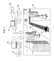
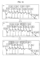
As shown in Fig. 3, the information stored in the
Claims (16)
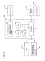
- A navigation apparatus for displaying navigation information generated based on map information, the navigation apparatus comprising:wherein the data processor calculates the altitudes of points on the route based on the node-based altitude data, and generates and outputs, to the display means, three-dimensional route information in which data of the calculated altitudes is set as a parameter.positional information acquiring means for acquiring positional information;storage means for storing two-dimensional map data, three-dimensional graphic data, and node-based altitude data of recorded altitude data of nodes which are set on a link used as a route;a data processor generating and outputting three-dimensional display information for a guidance region by receiving the positional information acquired by the positional information acquiring means, and acquiring data from the storage means based on the received positional information; anddisplay means for displaying the information output from the data processor,
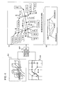
- The navigation apparatus according to claim 1, wherein the data processor calculates one of an altitude of the navigation apparatus and an altitude of a vehicle having the navigation apparatus based on the positional information acquired by the positional information acquiring means and the node-based altitude data, and generates and outputs, to the display means, symbol data which represents one of the navigation apparatus and the vehicle and in which information of the calculated altitude is set as a parameter for the three-dimensional display information.
- The navigation apparatus according to claim 1, wherein the data processor calculates one of an altitude of the navigation apparatus and an altitude of a vehicle having the navigation apparatus based on the positional information acquired by the positional information acquiring means and the node-based altitude data, and generates and outputs, to the display means, three-dimensional data obtained in observation from a camera viewpoint set within an allowable range for setting the camera viewpoint, the allowable range having altitudes not less than the calculated altitude.
- The navigation apparatus according to claim 1,
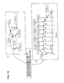
wherein the node-based altitude data stored in the storage means is recorded altitude data in units of nodes included in each of links used as routes having identifiers set therefor, and
wherein sequence information of a link identifier of a particular link to a destination is input to the data processor, and, based on altitude data of nodes included in a link selected based on the link identifier, three-dimensional route information reflecting altitude information is generated and output to the display means by the data processor. - The navigation apparatus according to claim 1, wherein the positional information acquired by the positional information acquiring means is input to the data processor, and the data processor executes processing in which, when three-dimensional data of a guidance point existing in a traveling direction is stored in the storage means, three-dimensional data of the guidance point is generated and output to the display means, and, when the three-dimensional data of the guidance point is not stored in the storage means, the two-dimensional map is acquired from the storage means and is output to the display means.
- The navigation apparatus according to claim 1,
wherein the storage means stores, as interpolation-point-based altitude data, altitude information of interpolation points which are each set between nodes, and
wherein the data processor calculates the altitudes of points on the route based on the interpolation-point-based altitude data, and generates and outputs, to the display means, one of symbol information of a vehicle having the navigation apparatus and three-dimensional route information in which data of the calculated altitudes is set as a parameter. - The navigation apparatus according to claim 6, wherein, in the altitude information of the interpolation points which are each set between nodes, the altitude of only one interpolation point of a set of two adjacent interpolation points having an altitude difference not greater than a predetermined threshold difference value is stored as the interpolation-point-based altitude data in the storage means.
- A data processing method for displaying navigation information generated based on map information, the data processing method comprising the steps of:wherein the step of generating and outputting the three-dimensional display information includes a step of calculating the altitudes of points on a route on the basis of node-based altitude data of recorded altitude data of nodes which are set on a link used as a route, the node-based altitude data being stored in the storage means, and generating and outputting, to display means, three-dimensional route information in which data of the calculated altitudes is set as a parameter.acquiring positional information;generating and outputting three-dimensional display information for a guidance region by receiving the positional information acquired in the step of acquiring the positional information, and acquiring, from storage means, data for use in generating the three-dimensional display information based on the received positional information; anddisplaying the three-dimensional display information generated in the step of generating and outputting the three-dimensional display information,
- The data processing method according to claim 8, wherein the step of generating and outputting the three-dimensional display information includes a step of calculating one of an altitude of a navigation apparatus and an altitude of a vehicle having the navigation apparatus based on the positional information acquired in the step of acquiring the positional information and the node-based altitude data, and generating and outputting, to the display means, symbol data which represents one of the navigation apparatus and the vehicle and in which information of the calculated altitude is set as a parameter for the three-dimensional display information.
- The data processing method according to claim 8, wherein the step of generating and outputting the three-dimensional display information includes a step of calculating one of an altitude of a navigation apparatus and an altitude of a vehicle having the navigation apparatus based on the positional information acquired in the step of acquiring the positional information and the node-based altitude data, and generating and outputting, to the display means, three-dimensional data obtained in observation from a camera viewpoint set within an allowable range for setting the camera viewpoint, the allowable range having altitudes not less than the calculated altitude.
- The data processing method according to claim 8,
wherein the node-based altitude data stored in the storage means is recorded altitude data in units of nodes included in each of links used as routes having identifiers set therefor, and
wherein the step of generating and outputting the three-dimensional display information includes a step of receiving sequence information of a link identifier of a particular link to a destination, and generating and outputting, to the display means, three-dimensional route information based on altitude data of nodes included in a link selected based on the link identifier, the three-dimensional route information reflecting altitude information. - The data processing method according to claim 8, wherein, in the step of generating and outputting the three-dimensional display information, after receiving the positional information acquired in the step of acquiring the positional information, when three-dimensional data of a guidance point existing in a traveling direction is stored in the storage means, three-dimensional data of the guidance point is generated and output to the display means, and, when the three-dimensional data of the guidance point is not stored in the storage means, two-dimensional map data is acquired from the storage means and is output to the display means.
- The data processing method according to claim 8, wherein the step of generating and outputting the three-dimensional display information includes a step of acquiring, from the storage means, interpolation-point-based altitude data used as altitude information of interpolation points which are each set between nodes, calculating the altitudes of points on the route based on the interpolation-point-based altitude data, and generating and outputting, to the display means, one of symbol information of a vehicle having the navigation apparatus and three-dimensional route information in which data of the calculated altitudes is set as a parameter.
- A computer program for executing processing for displaying navigation information generated based on map information, the computer program comprising the steps of:wherein the step of generating and outputting the three-dimensional display information includes a step of calculating the altitudes of points on a route on the basis of node-based altitude data of recorded altitude data of nodes which are set on a link used as a route, the node-based altitude data being stored in the storage means, and generating and outputting, to display means, three-dimensional route information in which data of the calculated altitudes is set as a parameter.acquiring positional information;generating and outputting three-dimensional display information for a guidance region by receiving the positional information acquired in the step of acquiring the positional information, and acquiring, from storage means, data for use in generating the three-dimensional display information based on the received positional information; anddisplaying the three-dimensional display information generated in the step of generating and outputting the three-dimensional display information,
- The computer program according to claim 14, wherein the step of generating and outputting the three-dimensional display information includes a step of acquiring, from the storage means, interpolation-point-based altitude data used as altitude information of interpolation points which are each set between nodes, calculating the altitudes of points on the route based on the interpolation-point-based altitude data, and generating and outputting, to the display means, one of symbol information of a vehicle having the navigation apparatus and three-dimensional route information in which data of the calculated altitudes is set as a parameter.
- A navigation apparatus for displaying navigation information generated based on map information, the navigation apparatus comprising:wherein the data processor calculates the altitudes of points on the route based on the node-based altitude data, and generates and outputs, to the display device, three-dimensional route information in which data of the calculated altitudes is set as a parameter.a positional information acquiring section acquiring positional information;a storage section storing two-dimensional map data, three-dimensional graphic data, and node-based altitude data of recorded altitude data of nodes which are set on a link used as a route;a data processor generating and outputting three-dimensional display information for a guidance region by receiving the positional information acquired by the positional information acquiring section, and acquiring data from the storage section based on the received positional information; anda display device displaying the information output from the data processor,
Applications Claiming Priority (4)
| Application Number | Priority Date | Filing Date | Title |
|---|---|---|---|
| JP2004110660 | 2004-04-05 | ||
| JP2004110660 | 2004-04-05 | ||
| JP2004230085A JP2005321370A (en) | 2004-04-05 | 2004-08-06 | Navigation system, data processing method and computer program |
| JP2004230085 | 2004-08-06 |
Publications (3)
| Publication Number | Publication Date |
|---|---|
| EP1584897A2 true EP1584897A2 (en) | 2005-10-12 |
| EP1584897A3 EP1584897A3 (en) | 2007-05-02 |
| EP1584897B1 EP1584897B1 (en) | 2015-11-04 |
Family
ID=34914560
Family Applications (1)
| Application Number | Title | Priority Date | Filing Date |
|---|---|---|---|
| EP05007323.8A Expired - Fee Related EP1584897B1 (en) | 2004-04-05 | 2005-04-04 | Navigation apparatus, and data processing method and computer program used therewith |
Country Status (4)
| Country | Link |
|---|---|
| US (1) | US7460952B2 (en) |
| EP (1) | EP1584897B1 (en) |
| JP (1) | JP2005321370A (en) |
| KR (1) | KR101116423B1 (en) |
Cited By (13)
| Publication number | Priority date | Publication date | Assignee | Title |
|---|---|---|---|---|
| EP1804027A1 (en) * | 2005-12-30 | 2007-07-04 | Robert Bosch Gmbh | Method and device for 3-dimensional representation of an area with roads |
| EP1873495A1 (en) | 2006-06-30 | 2008-01-02 | Aisin AW Co., Ltd. | Navigation apparatus with three-dimensional route guidance |
| WO2009133988A1 (en) | 2008-04-30 | 2009-11-05 | Thinkware Systems Corporation | Method and apparatus for creating of 3d direction displaying |
| US7974781B2 (en) * | 2006-06-30 | 2011-07-05 | Aisin Aw Co., Ltd. | Navigation apparatuses, methods, and programs for generation of a 3D movie |
| EP2530433A1 (en) * | 2011-06-01 | 2012-12-05 | Harman Becker Automotive Systems GmbH | Method of generating a database for a navigation device, method of outputting a three-dimensional map, and navigation device |
| WO2013057077A3 (en) * | 2011-10-21 | 2013-06-13 | Navteq B.V. | Three dimensional routing |
| US8553942B2 (en) | 2011-10-21 | 2013-10-08 | Navteq B.V. | Reimaging based on depthmap information |
| US9024970B2 (en) | 2011-12-30 | 2015-05-05 | Here Global B.V. | Path side image on map overlay |
| CN104613970A (en) * | 2014-07-24 | 2015-05-13 | 腾讯科技(深圳)有限公司 | Simulative navigation data generation method and client |
| US9047688B2 (en) | 2011-10-21 | 2015-06-02 | Here Global B.V. | Depth cursor and depth measurement in images |
| CN105765344A (en) * | 2013-10-11 | 2016-07-13 | 通腾导航技术股份有限公司 | Apparatus and methods of displaying navigation instructions |
| US9404764B2 (en) | 2011-12-30 | 2016-08-02 | Here Global B.V. | Path side imagery |
| EP2283467A4 (en) * | 2008-05-15 | 2017-02-15 | Thinkware Systems Corporation | System and method for displaying guidance symbol |
Families Citing this family (30)
| Publication number | Priority date | Publication date | Assignee | Title |
|---|---|---|---|---|
| CA2559726C (en) * | 2004-03-24 | 2015-10-20 | A9.Com, Inc. | System and method for displaying images in an online directory |
| TWI284856B (en) * | 2005-05-25 | 2007-08-01 | Asustek Comp Inc | Apparatus and method for processing three-dimensional images |
| JP2007093661A (en) * | 2005-09-27 | 2007-04-12 | Alpine Electronics Inc | Navigation system and map display device |
| KR100735564B1 (en) * | 2005-12-02 | 2007-07-04 | 삼성전자주식회사 | Apparatus, system, and method for mapping information |
| JP5007059B2 (en) * | 2006-03-28 | 2012-08-22 | クラリオン株式会社 | Stereoscopic in-vehicle display |
| JP4333704B2 (en) * | 2006-06-30 | 2009-09-16 | アイシン・エィ・ダブリュ株式会社 | Navigation device |
| JP2008139247A (en) * | 2006-12-05 | 2008-06-19 | Alpine Electronics Inc | Gps positioning device |
| EP2102596B1 (en) * | 2007-01-10 | 2018-01-03 | TomTom Navigation B.V. | Method of indicating traffic delays, computer program and navigation system therefor |
| JP4251218B2 (en) * | 2007-01-31 | 2009-04-08 | ソニー株式会社 | Information processing apparatus, image display apparatus, information processing system, control method therefor, and program for causing computer to execute the method |
| JP4577327B2 (en) * | 2007-04-09 | 2010-11-10 | 株式会社デンソー | Map display control device and program for map display control device |
| DE102007029841B4 (en) * | 2007-06-28 | 2011-12-22 | Airbus Operations Gmbh | Interactive information system for an aircraft |
| US8244454B2 (en) * | 2008-01-07 | 2012-08-14 | Tomtom International B.V. | Navigation device and method |
| JP4994256B2 (en) | 2008-01-28 | 2012-08-08 | 株式会社ジオ技術研究所 | Data structure of route guidance database |
| CA2720834A1 (en) * | 2008-05-29 | 2009-12-03 | Tomtom International B.V. | Displaying route information on a digital map image |
| JP5223062B2 (en) * | 2010-03-11 | 2013-06-26 | 株式会社ジオ技術研究所 | 3D map drawing system |
| US9026359B2 (en) * | 2010-11-01 | 2015-05-05 | Nokia Corporation | Visually representing a three-dimensional environment |
| EP2541207A1 (en) * | 2011-07-01 | 2013-01-02 | Harman Becker Automotive Systems GmbH | Vehicle navigation device and method |
| CN104596521B (en) | 2014-03-14 | 2018-04-27 | 腾讯科技(深圳)有限公司 | The display methods and device of a kind of route information |
| CN105336002B (en) * | 2014-08-01 | 2018-12-14 | 联想(北京)有限公司 | Information processing method and electronic equipment |
| US9528845B2 (en) * | 2014-08-27 | 2016-12-27 | Robert Bosch Gmbh | Occlusion-reduced 3D routing for 3D city maps |
| CN104268941A (en) * | 2014-09-23 | 2015-01-07 | 广州都市圈网络科技有限公司 | Hot spot forming method and device for simulated three-dimensional map |
| WO2016185637A1 (en) * | 2015-05-20 | 2016-11-24 | 三菱電機株式会社 | Point-cloud-image generation device and display system |
| CN105628034B (en) | 2016-02-04 | 2019-04-23 | 合肥杰发科技有限公司 | Navigation map update method and equipment |
| US9689700B1 (en) | 2016-03-18 | 2017-06-27 | Volkswagen Aktiengesellschaft | Apparatus, system and method for geometric linearization of navigational data |
| CN106204735B (en) * | 2016-07-18 | 2018-11-09 | 中国人民解放军理工大学 | Application method of the Unity3D terrain datas in 11 environment of Direct3D |
| WO2018034992A1 (en) * | 2016-08-13 | 2018-02-22 | Skymachines, Inc. | Sky machines |
| JP7257207B2 (en) * | 2019-03-22 | 2023-04-13 | 日立Astemo株式会社 | Environment recognition device |
| JP7282656B2 (en) * | 2019-11-11 | 2023-05-29 | 日立造船株式会社 | Movement process presentation device, movement process presentation method, movement process presentation program, and recording medium |
| KR102347232B1 (en) * | 2020-02-04 | 2022-01-04 | 네이버 주식회사 | Electronic device for providing visual localization based on outdoor three-dimension map information and operating method thereof |
| CN112444263B (en) * | 2020-09-22 | 2023-05-23 | 北京智行者科技股份有限公司 | Global path planning method and device |
Citations (3)
| Publication number | Priority date | Publication date | Assignee | Title |
|---|---|---|---|---|
| US6157342A (en) | 1997-05-27 | 2000-12-05 | Xanavi Informatics Corporation | Navigation device |
| EP1107189A2 (en) | 1999-12-09 | 2001-06-13 | Matsushita Electric Industrial Co., Ltd. | MAP displaying system and map displaying method |
| US20010028350A1 (en) | 1997-05-09 | 2001-10-11 | Xanavi Information Corporation | Map database device, map display apparatus and recording medium capable of efficiently having and utilizing height data |
Family Cites Families (17)
| Publication number | Priority date | Publication date | Assignee | Title |
|---|---|---|---|---|
| US5504482A (en) * | 1993-06-11 | 1996-04-02 | Rockwell International Corporation | Automobile navigation guidance, control and safety system |
| JP3568621B2 (en) * | 1995-04-20 | 2004-09-22 | 株式会社日立製作所 | Map display device |
| DE69635426T2 (en) * | 1995-06-13 | 2006-08-03 | Matsushita Electric Industrial Co., Ltd., Kadoma | Vehicle navigation device and recording medium for program storage therefor |
| JP3275673B2 (en) * | 1995-12-08 | 2002-04-15 | 松下電器産業株式会社 | Travel route guidance device |
| JP3428275B2 (en) * | 1996-02-16 | 2003-07-22 | 日産自動車株式会社 | Vehicle navigation system |
| JP3375258B2 (en) * | 1996-11-07 | 2003-02-10 | 株式会社日立製作所 | Map display method and device, and navigation device provided with the device |
| JP3474380B2 (en) * | 1996-12-12 | 2003-12-08 | 株式会社ザナヴィ・インフォマティクス | Navigation device and map database device |
| DE19801801C2 (en) * | 1997-01-20 | 2000-06-29 | Nissan Motor | Navigation system and storage medium for storing operating programs used for it |
| JPH10274537A (en) * | 1997-03-31 | 1998-10-13 | Toyota Motor Corp | Guide display device for vehicle |
| JP4559555B2 (en) * | 1999-03-16 | 2010-10-06 | 株式会社日立製作所 | 3D map display method and navigation apparatus |
| JP3471003B2 (en) * | 2000-02-02 | 2003-11-25 | 松下電器産業株式会社 | Intersection display method, map display device therefor, and recording medium |
| JP2002024862A (en) | 2000-07-07 | 2002-01-25 | Ntt Data Corp | Display control device and method using computer |
| JP5041638B2 (en) * | 2000-12-08 | 2012-10-03 | パナソニック株式会社 | Method for transmitting location information of digital map and device used therefor |
| JP4240446B2 (en) | 2002-06-24 | 2009-03-18 | 富士通テン株式会社 | Image display device |
| JP3992227B2 (en) * | 2002-04-26 | 2007-10-17 | パイオニア株式会社 | 3D information display device |
| JP4078905B2 (en) * | 2002-07-15 | 2008-04-23 | アイシン・エィ・ダブリュ株式会社 | Road gradient estimation device |
| US7130740B2 (en) * | 2003-11-07 | 2006-10-31 | Motorola, Inc. | Method and apparatus for generation of real-time graphical descriptions in navigational systems |
-
2004
- 2004-08-06 JP JP2004230085A patent/JP2005321370A/en active Pending
-
2005
- 2005-04-04 EP EP05007323.8A patent/EP1584897B1/en not_active Expired - Fee Related
- 2005-04-04 KR KR1020050027938A patent/KR101116423B1/en not_active IP Right Cessation
- 2005-04-04 US US11/098,677 patent/US7460952B2/en not_active Expired - Fee Related
Patent Citations (3)
| Publication number | Priority date | Publication date | Assignee | Title |
|---|---|---|---|---|
| US20010028350A1 (en) | 1997-05-09 | 2001-10-11 | Xanavi Information Corporation | Map database device, map display apparatus and recording medium capable of efficiently having and utilizing height data |
| US6157342A (en) | 1997-05-27 | 2000-12-05 | Xanavi Informatics Corporation | Navigation device |
| EP1107189A2 (en) | 1999-12-09 | 2001-06-13 | Matsushita Electric Industrial Co., Ltd. | MAP displaying system and map displaying method |
Cited By (29)
| Publication number | Priority date | Publication date | Assignee | Title |
|---|---|---|---|---|
| EP1804027A1 (en) * | 2005-12-30 | 2007-07-04 | Robert Bosch Gmbh | Method and device for 3-dimensional representation of an area with roads |
| EP1873495A1 (en) | 2006-06-30 | 2008-01-02 | Aisin AW Co., Ltd. | Navigation apparatus with three-dimensional route guidance |
| US7835861B2 (en) | 2006-06-30 | 2010-11-16 | Aisin Aw Co., Ltd. | Navigation apparatuses, methods, and programs for generation of a 3D movie |
| US7974781B2 (en) * | 2006-06-30 | 2011-07-05 | Aisin Aw Co., Ltd. | Navigation apparatuses, methods, and programs for generation of a 3D movie |
| US8743110B2 (en) | 2008-04-30 | 2014-06-03 | Thinkware Systems Corporation | Method and apparatus for creating of 3D direction displaying |
| WO2009133988A1 (en) | 2008-04-30 | 2009-11-05 | Thinkware Systems Corporation | Method and apparatus for creating of 3d direction displaying |
| EP2283465A1 (en) * | 2008-04-30 | 2011-02-16 | Thinkware Systems Corporation | Method and apparatus for creating of 3d direction displaying |
| EP2283465A4 (en) * | 2008-04-30 | 2013-01-23 | Thinkware Systems Corp | Method and apparatus for creating of 3d direction displaying |
| EP2283467A4 (en) * | 2008-05-15 | 2017-02-15 | Thinkware Systems Corporation | System and method for displaying guidance symbol |
| WO2012164010A1 (en) * | 2011-06-01 | 2012-12-06 | Harman Becker Automotive Systems Gmbh | Method of generating a database for a navigation device, method of outputting a three-dimensional map, and navigation device |
| EP2530433A1 (en) * | 2011-06-01 | 2012-12-05 | Harman Becker Automotive Systems GmbH | Method of generating a database for a navigation device, method of outputting a three-dimensional map, and navigation device |
| CN103562681A (en) * | 2011-06-01 | 2014-02-05 | 哈曼贝克自动系统股份有限公司 | Method of generating a database for a navigation device, method of outputting a three-dimensional map, and navigation device |
| CN103562681B (en) * | 2011-06-01 | 2017-10-27 | 哈曼贝克自动系统股份有限公司 | Produce the method for the database for guider, export the method and guider of three-dimensional map |
| US9574897B2 (en) | 2011-06-01 | 2017-02-21 | Harman Becker Automotive Systems Gmbh | Method of generating a database for a navigation device, method of outputting a three-dimensional map, and navigation device |
| WO2013057077A3 (en) * | 2011-10-21 | 2013-06-13 | Navteq B.V. | Three dimensional routing |
| US9641755B2 (en) | 2011-10-21 | 2017-05-02 | Here Global B.V. | Reimaging based on depthmap information |
| US9047688B2 (en) | 2011-10-21 | 2015-06-02 | Here Global B.V. | Depth cursor and depth measurement in images |
| US9116011B2 (en) | 2011-10-21 | 2015-08-25 | Here Global B.V. | Three dimensional routing |
| US9390519B2 (en) | 2011-10-21 | 2016-07-12 | Here Global B.V. | Depth cursor and depth management in images |
| US8553942B2 (en) | 2011-10-21 | 2013-10-08 | Navteq B.V. | Reimaging based on depthmap information |
| US9024970B2 (en) | 2011-12-30 | 2015-05-05 | Here Global B.V. | Path side image on map overlay |
| US9558576B2 (en) | 2011-12-30 | 2017-01-31 | Here Global B.V. | Path side image in map overlay |
| US9404764B2 (en) | 2011-12-30 | 2016-08-02 | Here Global B.V. | Path side imagery |
| US10235787B2 (en) | 2011-12-30 | 2019-03-19 | Here Global B.V. | Path side image in map overlay |
| CN105765344A (en) * | 2013-10-11 | 2016-07-13 | 通腾导航技术股份有限公司 | Apparatus and methods of displaying navigation instructions |
| US10527445B2 (en) | 2013-10-11 | 2020-01-07 | Tomtom Navigation B.V. | Apparatus and methods of displaying navigation instructions |
| US11493358B2 (en) | 2013-10-11 | 2022-11-08 | Tomtom Navigation B.V. | Apparatus and methods of displaying navigation instructions |
| CN104613970B (en) * | 2014-07-24 | 2018-01-12 | 腾讯科技(深圳)有限公司 | The data creation method and client of a kind of analogue navigation |
| CN104613970A (en) * | 2014-07-24 | 2015-05-13 | 腾讯科技(深圳)有限公司 | Simulative navigation data generation method and client |
Also Published As
| Publication number | Publication date |
|---|---|
| JP2005321370A (en) | 2005-11-17 |
| KR20060045469A (en) | 2006-05-17 |
| EP1584897A3 (en) | 2007-05-02 |
| US7460952B2 (en) | 2008-12-02 |
| KR101116423B1 (en) | 2012-03-08 |
| EP1584897B1 (en) | 2015-11-04 |
| US20050234638A1 (en) | 2005-10-20 |
Similar Documents
| Publication | Publication Date | Title |
|---|---|---|
| US7460952B2 (en) | Navigation apparatus, and data processing method and computer program used therewith | |
| EP2503289B1 (en) | Management of icons for digital maps | |
| US6567744B1 (en) | In-vehicle navigation apparatus | |
| EP2075543A2 (en) | Three-dimensional map display navigation device, three-dimensional map display system, and three-dimensional map display program | |
| EP2503293B1 (en) | Labelling of map elements in digital maps | |
| EP2503290A1 (en) | Curved labeling in digital maps | |
| EP2503292B1 (en) | Landmark icons in digital maps | |
| MX2007015265A (en) | Method for determining traffic information, and a device arranged to perform the method. | |
| JP7173750B2 (en) | Map information generation device, automatic driving system, and automatic driving control information generation device | |
| JP2008249539A (en) | Map display system, terminal device, map display server, and map display method | |
| JPWO2020070766A1 (en) | Map display device and map display method | |
| JP7100339B1 (en) | Route guidance program and route guidance device | |
| JP2010054754A (en) | Data structure of map data | |
| WO2004099719A1 (en) | Method and system for providing map information to mobile device | |
| JP6607657B2 (en) | New road estimation support device, new road estimation support method, computer program, and recording medium recording computer program | |
| JP4506862B2 (en) | Navigation device, data processing method, and computer program | |
| WO2004100106A1 (en) | Method and apparatus for displaying map for navigation | |
| JP2006250662A (en) | Navigation system and method of searching guidance route | |
| JPH09257503A (en) | Route searching method | |
| JP7473444B2 (en) | Navigation device, navigation method, and program | |
| JP7133628B2 (en) | Map display system and map display program | |
| JP6483421B2 (en) | In-vehicle device | |
| JP4930795B2 (en) | Navigation device and navigation program | |
| KR20100040623A (en) | Method for matching and storing of 3 dimension link in navigation system | |
| JP2005069783A (en) | Navigation apparatus and route search method |
Legal Events
| Date | Code | Title | Description |
|---|---|---|---|
| PUAI | Public reference made under article 153(3) epc to a published international application that has entered the european phase |
Free format text: ORIGINAL CODE: 0009012 |
|
| AK | Designated contracting states |
Kind code of ref document: A2 Designated state(s): AT BE BG CH CY CZ DE DK EE ES FI FR GB GR HU IE IS IT LI LT LU MC NL PL PT RO SE SI SK TR |
|
| AX | Request for extension of the european patent |
Extension state: AL BA HR LV MK YU |
|
| PUAL | Search report despatched |
Free format text: ORIGINAL CODE: 0009013 |
|
| AK | Designated contracting states |
Kind code of ref document: A3 Designated state(s): AT BE BG CH CY CZ DE DK EE ES FI FR GB GR HU IE IS IT LI LT LU MC NL PL PT RO SE SI SK TR |
|
| AX | Request for extension of the european patent |
Extension state: AL BA HR LV MK YU |
|
| RIC1 | Information provided on ipc code assigned before grant |
Ipc: G06T 17/50 20060101ALI20070323BHEP Ipc: G01C 21/36 20060101AFI20050630BHEP |
|
| 17P | Request for examination filed |
Effective date: 20071005 |
|
| AKX | Designation fees paid |
Designated state(s): DE FR GB |
|
| 17Q | First examination report despatched |
Effective date: 20121107 |
|
| REG | Reference to a national code |
Ref country code: DE Ref legal event code: R079 Ref document number: 602005047820 Country of ref document: DE Free format text: PREVIOUS MAIN CLASS: G01C0021360000 Ipc: G06T0017050000 |
|
| GRAP | Despatch of communication of intention to grant a patent |
Free format text: ORIGINAL CODE: EPIDOSNIGR1 |
|
| RIC1 | Information provided on ipc code assigned before grant |
Ipc: G06T 17/05 20110101AFI20150319BHEP |
|
| INTG | Intention to grant announced |
Effective date: 20150421 |
|
| GRAS | Grant fee paid |
Free format text: ORIGINAL CODE: EPIDOSNIGR3 |
|
| RAP1 | Party data changed (applicant data changed or rights of an application transferred) |
Owner name: SONY CORPORATION |
|
| RIN1 | Information on inventor provided before grant (corrected) |
Inventor name: OKUDA, SHIZUE Inventor name: OGAKI, TADAO |
|
| GRAA | (expected) grant |
Free format text: ORIGINAL CODE: 0009210 |
|
| AK | Designated contracting states |
Kind code of ref document: B1 Designated state(s): DE FR GB |
|
| REG | Reference to a national code |
Ref country code: GB Ref legal event code: FG4D |
|
| REG | Reference to a national code |
Ref country code: DE Ref legal event code: R096 Ref document number: 602005047820 Country of ref document: DE |
|
| REG | Reference to a national code |
Ref country code: DE Ref legal event code: R097 Ref document number: 602005047820 Country of ref document: DE |
|
| PLBE | No opposition filed within time limit |
Free format text: ORIGINAL CODE: 0009261 |
|
| STAA | Information on the status of an ep patent application or granted ep patent |
Free format text: STATUS: NO OPPOSITION FILED WITHIN TIME LIMIT |
|
| 26N | No opposition filed |
Effective date: 20160805 |
|
| GBPC | Gb: european patent ceased through non-payment of renewal fee |
Effective date: 20160404 |
|
| REG | Reference to a national code |
Ref country code: FR Ref legal event code: ST Effective date: 20161230 |
|
| PG25 | Lapsed in a contracting state [announced via postgrant information from national office to epo] |
Ref country code: FR Free format text: LAPSE BECAUSE OF NON-PAYMENT OF DUE FEES Effective date: 20160502 Ref country code: GB Free format text: LAPSE BECAUSE OF NON-PAYMENT OF DUE FEES Effective date: 20160404 |
|
| PGFP | Annual fee paid to national office [announced via postgrant information from national office to epo] |
Ref country code: DE Payment date: 20190418 Year of fee payment: 15 |
|
| REG | Reference to a national code |
Ref country code: DE Ref legal event code: R119 Ref document number: 602005047820 Country of ref document: DE |
|
| PG25 | Lapsed in a contracting state [announced via postgrant information from national office to epo] |
Ref country code: DE Free format text: LAPSE BECAUSE OF NON-PAYMENT OF DUE FEES Effective date: 20201103 |