EP1380853A2 - Ranging system for determining ranging information of a spacecraft - Google Patents
Ranging system for determining ranging information of a spacecraft Download PDFInfo
- Publication number
- EP1380853A2 EP1380853A2 EP03077055A EP03077055A EP1380853A2 EP 1380853 A2 EP1380853 A2 EP 1380853A2 EP 03077055 A EP03077055 A EP 03077055A EP 03077055 A EP03077055 A EP 03077055A EP 1380853 A2 EP1380853 A2 EP 1380853A2
- Authority
- EP
- European Patent Office
- Prior art keywords
- spacecraft
- reference signal
- sat
- component
- receiving
- Prior art date
- Legal status (The legal status is an assumption and is not a legal conclusion. Google has not performed a legal analysis and makes no representation as to the accuracy of the status listed.)
- Withdrawn
Links
Images


Classifications
-
- H—ELECTRICITY
- H04—ELECTRIC COMMUNICATION TECHNIQUE
- H04B—TRANSMISSION
- H04B7/00—Radio transmission systems, i.e. using radiation field
- H04B7/14—Relay systems
- H04B7/15—Active relay systems
- H04B7/185—Space-based or airborne stations; Stations for satellite systems
- H04B7/18578—Satellite systems for providing broadband data service to individual earth stations
- H04B7/18597—Arrangements for system physical machines management, i.e. for construction, operations control, administration, maintenance
-
- G—PHYSICS
- G01—MEASURING; TESTING
- G01S—RADIO DIRECTION-FINDING; RADIO NAVIGATION; DETERMINING DISTANCE OR VELOCITY BY USE OF RADIO WAVES; LOCATING OR PRESENCE-DETECTING BY USE OF THE REFLECTION OR RERADIATION OF RADIO WAVES; ANALOGOUS ARRANGEMENTS USING OTHER WAVES
- G01S13/00—Systems using the reflection or reradiation of radio waves, e.g. radar systems; Analogous systems using reflection or reradiation of waves whose nature or wavelength is irrelevant or unspecified
- G01S13/02—Systems using reflection of radio waves, e.g. primary radar systems; Analogous systems
- G01S13/06—Systems determining position data of a target
- G01S13/46—Indirect determination of position data
-
- G—PHYSICS
- G01—MEASURING; TESTING
- G01S—RADIO DIRECTION-FINDING; RADIO NAVIGATION; DETERMINING DISTANCE OR VELOCITY BY USE OF RADIO WAVES; LOCATING OR PRESENCE-DETECTING BY USE OF THE REFLECTION OR RERADIATION OF RADIO WAVES; ANALOGOUS ARRANGEMENTS USING OTHER WAVES
- G01S13/00—Systems using the reflection or reradiation of radio waves, e.g. radar systems; Analogous systems using reflection or reradiation of waves whose nature or wavelength is irrelevant or unspecified
- G01S13/87—Combinations of radar systems, e.g. primary radar and secondary radar
- G01S13/878—Combination of several spaced transmitters or receivers of known location for determining the position of a transponder or a reflector
-
- G—PHYSICS
- G01—MEASURING; TESTING
- G01S—RADIO DIRECTION-FINDING; RADIO NAVIGATION; DETERMINING DISTANCE OR VELOCITY BY USE OF RADIO WAVES; LOCATING OR PRESENCE-DETECTING BY USE OF THE REFLECTION OR RERADIATION OF RADIO WAVES; ANALOGOUS ARRANGEMENTS USING OTHER WAVES
- G01S5/00—Position-fixing by co-ordinating two or more direction or position line determinations; Position-fixing by co-ordinating two or more distance determinations
- G01S5/02—Position-fixing by co-ordinating two or more direction or position line determinations; Position-fixing by co-ordinating two or more distance determinations using radio waves
- G01S5/14—Determining absolute distances from a plurality of spaced points of known location
-
- G—PHYSICS
- G01—MEASURING; TESTING
- G01S—RADIO DIRECTION-FINDING; RADIO NAVIGATION; DETERMINING DISTANCE OR VELOCITY BY USE OF RADIO WAVES; LOCATING OR PRESENCE-DETECTING BY USE OF THE REFLECTION OR RERADIATION OF RADIO WAVES; ANALOGOUS ARRANGEMENTS USING OTHER WAVES
- G01S13/00—Systems using the reflection or reradiation of radio waves, e.g. radar systems; Analogous systems using reflection or reradiation of waves whose nature or wavelength is irrelevant or unspecified
- G01S13/02—Systems using reflection of radio waves, e.g. primary radar systems; Analogous systems
- G01S13/06—Systems determining position data of a target
- G01S13/46—Indirect determination of position data
- G01S2013/466—Indirect determination of position data by Trilateration, i.e. two antennas or two sensors determine separately the distance to a target, whereby with the knowledge of the baseline length, i.e. the distance between the antennas or sensors, the position data of the target is determined
Landscapes
- Engineering & Computer Science (AREA)
- Radar, Positioning & Navigation (AREA)
- Remote Sensing (AREA)
- Physics & Mathematics (AREA)
- General Physics & Mathematics (AREA)
- Computer Networks & Wireless Communication (AREA)
- Astronomy & Astrophysics (AREA)
- Aviation & Aerospace Engineering (AREA)
- Signal Processing (AREA)
- Radio Relay Systems (AREA)
- Position Fixing By Use Of Radio Waves (AREA)
- Radar Systems Or Details Thereof (AREA)
Abstract
Description


- Receiving control signals from the ground to initiate manoeuvres and to change the state or mode of operation of equipment.
- Transmitting results of measurements, information concerning satellite operation, the operation of equipment and verification of the execution of commands to the ground.
- Enabling measurement of the ground-satellite distance, and possibly the radial velocity, in order to permit location of the satellite.
and wherein the reference signal is arranged to be received by a correlation receiver.
- Fig. 1
- shows the basic configuration of a trilateration measurement,
- Fig. 2
- shows the practical configuration of a quadrilateration measurement,
- Fig. 3
- shows a transmission and receiving station with a compensation of the time delay introduced by the receiving arrangement,
- Fig. 4
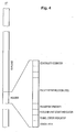
- shows a diagram of a transport stream according to the MPEG-2 standard,
- Fig. 5
- shows the practical configuration of a quadrilateration measurement according to pseudo ranging,
- Fig. 6
- shows separate transmission and receiving stations with a compensation of the time delay introduced by the receiving arrangement,
- Fig. 7
- shows a satellite carrying a transponder with a global coverage,
- Fig. 8
- shows a satellite carrying a transponder with a coverage by several narrow beams,
- Fig. 9
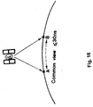
- shows the effect of reduced spatial separation between different ranging stations,
- Fig. 10
- shows a satellite carrying a transponder with a coverage by a spot beam and by a correlation receiver,
- Fig. 11
- shows the antenna pattern of a satellite antenna,
- Fig. 12
- shows the relationship between the downlink EIRP and the C/N ratio of a signal received at a receiving station,
- Fig. 13
- shows the interconnection of a processing station with remote receiving stations,
- Figs. 14 - 17
- show different time transfer techniques,
- Fig. 18
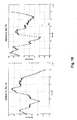
- shows the measurement of the time synchronisation error for different receiving stations with regard to one satellite,
- Fig. 19
- shows the measurement of the time synchronisation error for different receiving stations with regard to two different satellites,
- Fig. 20
- shows the basic configuration of a pseudo range measurement with regard to two different satellites, and
- Fig. 21
- shows the processing equipment for one receiving station of the basic configuration according to Fig. 20.
Claims (14)
- Ranging system for determining ranging information of a first spacecraft (Sat 2A) with the aid of a second spacecraft (Sat 1A) whose ranging information is known, wherein the first spacecraft (Sat 2A) carries a first component of a communication channel and wherein the second spacecraft (Sat 1A) carries a second component of a communication channel, comprising:a plurality of receiving stations at different locations on earth, wherein each receiving station is adapted to receive a first reference signal from the first component and a second reference signal from the second component;synchronisation means adapted to provide a synchronised time base between the plurality of receiving stations;calculation means adapted to calculate said ranging information in accordance with the propagation time of the first reference signal, wherein the synchronisation error of the synchronised time base is corrected by the known ranging information of the second spacecraft (Sat 1A) on the basis of the second reference signal.
- Ranging system according to claim 1, wherein at least one receiving station comprises a correlation receiver yielding a correlation gain for receiving the first reference signal and/or the second reference signal.
- Ranging system according to claim 2, wherein the correlation receiver is based on the correlation of a predetermined signal pattern contained in the first reference signal and/or the second reference signal.
- Ranging system according to claim 2, wherein the correlation receiver is based on the spread spectrum demodulation of a spread spectrum signal.
- Ranging system according to claim 4, wherein the spread spectrum demodulation yields a processing gain which corresponds to the correlation gain.
- Ranging method for determining ranging information of a first spacecraft (Sat 2A) with the aid of a second spacecraft (Sat 1A) whose ranging information is known, wherein the first spacecraft (Sat 2A) carries a first component of a communication channel and wherein the second spacecraft (Sat 1A) carries a second component of a communication channel, comprising the steps of:receiving a first reference signal from said first component and a second reference signal from said second component independently by a plurality of receiving stations at different locations on earth;providing a synchronised time base between the plurality of receiving stations;calculating said ranging information in accordance with the propagation time of the first reference signal, wherein the synchronisation error of the synchronised time base is corrected by the known ranging information of the second spacecraft (Sat 1A) on the basis of the second reference signal.
- Method according to claim 6, wherein for at least one receiving station a correlation method yielding a correlation gain for receiving the first reference signal and/or the second reference signal is applied.
- Method according to claim 7, wherein the correlation method is based on the correlation of a predetermined signal pattern contained in the first reference signal and/or the second reference signal.
- Method according to claim 7, wherein the correlation method is based on the spread spectrum demodulation of a spread spectrum signal.
- Method according to claim 9, wherein the spread spectrum demodulation yields a processing gain which corresponds to the correlation gain.
- Receiving station for providing ranging information of a first spacecraft (Sat 2A) with the aid of a second spacecraft (Sat 1A) whose ranging information is known, wherein the first spacecraft (Sat 2A) carries a first component of a communication channel and wherein the second spacecraft (Sat 1A) carries a second component of a communication channel, comprising:an antenna adapted to receive a first reference signal from said first component and a second reference signal from said second component;synchronisation means adapted to provide a synchronised time base between said receiving station and a reference point on earth, wherein the synchronisation error of the synchronised time base is corrected by the known ranging information of the second spacecraft (Sat 1A) on the basis of the second reference signal; andmeasurement means adapted to measure the propagation time of the first reference signal in accordance with the corrected synchronised time base.
- Method for operating a receiving station for providing ranging information of a first spacecraft (Sat 2A) with the aid of a second spacecraft (Sat 1A) whose ranging information is known, wherein the first spacecraft (Sat 2A) carries a first component of a communication channel and wherein the second spacecraft (Sat 1A) carries a second component of a communication channel, comprising the steps of:receiving a first reference signal from said first component and a second reference signal from said second component;providing a synchronised time base between said receiving station and a reference point on earth, wherein the synchronisation error of the synchronised time base is corrected by the known ranging information of the second spacecraft (Sat 1A) on the basis of the second reference signal; andmeasuring the propagation time of the first reference signal in accordance with the corrected synchronised time base.
- Processing station for processing ranging information of a first spacecraft (Sat 2A) with the aid of a second spacecraft (Sat 1A) whose ranging information is known, wherein the first spacecraft (Sat 2A) carries a first component of a communication channel and wherein the second spacecraft (Sat 1A) carries a second component of a communication channel, comprising:wherein each receiving station is adapted to receive a first reference signal from the first component and a second reference signal from the second component, wherein a synchronised time base is provided between the plurality of receiving stations, and wherein the synchronisation error of the synchronised time base is corrected by the known ranging information of the second spacecraft (Sat 1A) on the basis of the second reference signal.propagation time data receiving means adapted to receive propagation time data from a plurality of receiving stations at different locations on earth;
- Processing method for processing ranging information of a first spacecraft (Sat 2A) with the aid of a second spacecraft (Sat 1A) whose ranging information is known, wherein the first spacecraft (Sat 2A) carries a first component of a communication channel and wherein the second spacecraft (Sat 1A) carries a second component of a communication channel, comprising the steps of:wherein each receiving station is adapted to receive a first reference signal from the first component and a second reference signal from the second component,receiving propagation time data from a plurality of receiving stations at different locations on earth;
wherein a synchronised time base is provided between the plurality of receiving stations, and wherein the synchronisation error of the synchronised time base is corrected by the known ranging information of the second spacecraft (Sat 1A) on the basis of the second reference signal.
Applications Claiming Priority (1)
| Application Number | Priority Date | Filing Date | Title |
|---|---|---|---|
| EP01108029A EP1245967A1 (en) | 2001-03-29 | 2001-03-29 | Ranging system for determining ranging information of a spacecraft |
Related Parent Applications (2)
| Application Number | Title | Priority Date | Filing Date |
|---|---|---|---|
| EP01108029.8 Division | 2001-03-29 | ||
| EP01108029A Division EP1245967A1 (en) | 2001-03-29 | 2001-03-29 | Ranging system for determining ranging information of a spacecraft |
Publications (2)
| Publication Number | Publication Date |
|---|---|
| EP1380853A2 true EP1380853A2 (en) | 2004-01-14 |
| EP1380853A3 EP1380853A3 (en) | 2008-04-23 |
Family
ID=8176996
Family Applications (3)
| Application Number | Title | Priority Date | Filing Date |
|---|---|---|---|
| EP03077055A Withdrawn EP1380853A3 (en) | 2001-03-29 | 2001-03-29 | Ranging system for determining ranging information of a spacecraft |
| EP01108029A Ceased EP1245967A1 (en) | 2001-03-29 | 2001-03-29 | Ranging system for determining ranging information of a spacecraft |
| EP02716070A Withdrawn EP1381883A1 (en) | 2001-03-29 | 2002-01-15 | Ranging system for determining ranging information of a spacecraft |
Family Applications After (2)
| Application Number | Title | Priority Date | Filing Date |
|---|---|---|---|
| EP01108029A Ceased EP1245967A1 (en) | 2001-03-29 | 2001-03-29 | Ranging system for determining ranging information of a spacecraft |
| EP02716070A Withdrawn EP1381883A1 (en) | 2001-03-29 | 2002-01-15 | Ranging system for determining ranging information of a spacecraft |
Country Status (10)
| Country | Link |
|---|---|
| US (1) | US7512505B2 (en) |
| EP (3) | EP1380853A3 (en) |
| JP (1) | JP4421819B2 (en) |
| CN (1) | CN1294707C (en) |
| AR (1) | AR033076A1 (en) |
| AU (1) | AU2002226413B2 (en) |
| BR (1) | BR0208538A (en) |
| CA (1) | CA2442253A1 (en) |
| EA (1) | EA005559B1 (en) |
| WO (1) | WO2002079800A1 (en) |
Cited By (1)
| Publication number | Priority date | Publication date | Assignee | Title |
|---|---|---|---|---|
| US9638785B2 (en) | 2010-03-19 | 2017-05-02 | Sky Perfect Jsat Corporation | Position measurement system for geostationary artificial satellite |
Families Citing this family (51)
| Publication number | Priority date | Publication date | Assignee | Title |
|---|---|---|---|---|
| DE10259638B4 (en) * | 2002-12-18 | 2004-12-09 | Intersecure Logic Limited | Service vehicle to perform actions on a target spacecraft, maintenance system, and method of using a service vehicle |
| US20050027450A1 (en) * | 2003-08-01 | 2005-02-03 | Cox Geoffrey F. | Altitude aiding in a satellite positioning system |
| JP4963063B2 (en) * | 2004-06-09 | 2012-06-27 | インターナショナル・ビジネス・マシーンズ・コーポレーション | Distance measuring system, distance measuring method, information processing apparatus, program, and recording medium |
| US7183969B2 (en) * | 2004-12-22 | 2007-02-27 | Raytheon Company | System and technique for calibrating radar arrays |
| EP1739450A1 (en) * | 2005-06-30 | 2007-01-03 | SES Astra S.A. | Method and apparatus for determining the location of a stationary satellite receiver |
| KR20070041923A (en) * | 2005-10-17 | 2007-04-20 | 김정선 | Multi-functional system for extending and modulating 130dbm frequency of gps terminal for life jacket |
| US10281557B2 (en) | 2005-12-15 | 2019-05-07 | Polte Corporation | Partially synchronized multilateration/trilateration method and system for positional finding using RF |
| US10834531B2 (en) | 2005-12-15 | 2020-11-10 | Polte Corporation | Multi-path mitigation in rangefinding and tracking objects using reduced attenuation RF technology |
| ES2407817T3 (en) * | 2006-01-19 | 2013-06-14 | Thales | Relative position control device (s) by means of signal power measurements, for a space ingenuity of a group of spacecraft in formation |
| US7489271B2 (en) * | 2006-03-22 | 2009-02-10 | Lockheed Martin Corporation | Optimized receive antenna and system for precision GPS-at-GEO navigation |
| CN101127555B (en) * | 2006-08-18 | 2011-12-07 | 北京华信泰科技有限公司 | System and method for ground supplementary transmitter and wireless digital broadcast synchronization |
| RU2467467C2 (en) * | 2008-01-24 | 2012-11-20 | Ажанс Спасьяль Эропеен | Method for compensating signal distortion in emitting payload |
| ATE524747T1 (en) * | 2008-07-24 | 2011-09-15 | Ses Astra Sa | SYSTEM AND METHOD FOR CALCULATION OF A SPACEBODY POSITION |
| CA2764120C (en) * | 2009-01-27 | 2019-01-08 | Xyz Interactive Technologies Inc. | A method and apparatus for ranging finding, orienting, and/or positioning of single and/or multiple devices |
| FR2960653B1 (en) * | 2010-06-01 | 2012-07-27 | Thales Sa | SYSTEM FOR POSITIONING A GEOSTATIONARY SATELLITE |
| US11125850B2 (en) | 2011-08-03 | 2021-09-21 | Polte Corporation | Systems and methods for determining a timing offset of emitter antennas in a wireless network |
| US11835639B2 (en) | 2011-08-03 | 2023-12-05 | Qualcomm Technologies, Inc. | Partially synchronized multilateration or trilateration method and system for positional finding using RF |
| US8736487B2 (en) | 2011-09-21 | 2014-05-27 | Csr Technology Inc. | Method and apparatus of using height aiding from a contour table for GNSS positioning |
| CN102523016B (en) * | 2011-12-15 | 2013-04-10 | 中国电子科技集团公司第十研究所 | Distance measuring method using frequency hopping pattern to solve fuzzy distance |
| FR2985121B1 (en) * | 2011-12-22 | 2014-01-17 | Astrium Sas | METHOD AND SYSTEM FOR ESTIMATING A MARKET DIFFERENCE OF A TARGET SIGNAL ISSUED BY A DEVICE IN TERRESTRIAL OR AIR ORBIT |
| US9365303B2 (en) * | 2012-05-03 | 2016-06-14 | Raytheon Company | Position and elevation acquisition for orbit determination |
| US9019155B2 (en) | 2012-05-03 | 2015-04-28 | Raytheon Company | Global positioning system (GPS) and doppler augmentation (GDAUG) and space location inertial navigation geopositioning system (SPACELINGS) |
| CN102752012A (en) * | 2012-05-15 | 2012-10-24 | 北京航空航天大学 | Air vehicle measurement and control system with upper and down links utilizing different spectrum spreading systems |
| US9386550B2 (en) * | 2012-06-11 | 2016-07-05 | Viasat Inc. | Tandem satellite frame synchronization |
| US9075126B2 (en) | 2012-06-28 | 2015-07-07 | Raytheon Company | Ground location inertial navigation geopositioning system (groundlings) |
| US10440512B2 (en) | 2012-08-03 | 2019-10-08 | Polte Corporation | Angle of arrival (AOA) positioning method and system for positional finding and tracking objects using reduced attenuation RF technology |
| US10845453B2 (en) | 2012-08-03 | 2020-11-24 | Polte Corporation | Network architecture and methods for location services |
| US10863313B2 (en) | 2014-08-01 | 2020-12-08 | Polte Corporation | Network architecture and methods for location services |
| CN103529454A (en) * | 2013-11-06 | 2014-01-22 | 中国科学院上海天文台 | Multi-telescope laser ranging system and method |
| JP6320029B2 (en) * | 2013-12-25 | 2018-05-09 | 三菱電機株式会社 | Positioning device and positioning method |
| US10144533B2 (en) | 2014-05-14 | 2018-12-04 | California Institute Of Technology | Large-scale space-based solar power station: multi-scale modular space power |
| US11128179B2 (en) | 2014-05-14 | 2021-09-21 | California Institute Of Technology | Large-scale space-based solar power station: power transmission using steerable beams |
| JP6640116B2 (en) | 2014-06-02 | 2020-02-05 | カリフォルニア インスティチュート オブ テクノロジー | Large Space Solar Power Plants: Efficient Power Generation Tiles |
| JP6557849B2 (en) * | 2014-08-01 | 2019-08-14 | ポルテ・コーポレイションPoLTE Corporation | Partially synchronized multi-side / tri-side survey method and system for position finding using RF |
| CA2963578A1 (en) | 2014-10-07 | 2016-04-14 | Xyz Interactive Technologies Inc. | Device and method for orientation and positioning |
| EP3325347B1 (en) | 2015-07-22 | 2021-06-16 | California Institute of Technology | Large-area structures for compact packaging |
| JP2018530180A (en) | 2015-08-10 | 2018-10-11 | カリフォルニア インスティチュート オブ テクノロジー | System and method for controlling the supply voltage of a stacked power amplifier |
| US10992253B2 (en) | 2015-08-10 | 2021-04-27 | California Institute Of Technology | Compactable power generation arrays |
| US10509097B2 (en) * | 2016-03-31 | 2019-12-17 | Hughes Network Systems, Llc | Correcting satellite pointing direction |
| CN106772510B (en) * | 2016-12-15 | 2019-05-31 | 浙江大学 | A kind of frequency hopping distance measuring method based on carrier phase measurement |
| US11255945B2 (en) | 2018-03-27 | 2022-02-22 | Polte Corporation | Multi-path mitigation in tracking objects using compressed RF data |
| US11634240B2 (en) | 2018-07-17 | 2023-04-25 | California Institute Of Technology | Coilable thin-walled longerons and coilable structures implementing longerons and methods for their manufacture and coiling |
| CN109307875A (en) * | 2018-10-28 | 2019-02-05 | 西南电子技术研究所(中国电子科技集团公司第十研究所) | Aerial target multi stations intersection real-time navigation localization method |
| US11772826B2 (en) | 2018-10-31 | 2023-10-03 | California Institute Of Technology | Actively controlled spacecraft deployment mechanism |
| CN111343579B (en) | 2018-12-19 | 2021-08-06 | 大唐移动通信设备有限公司 | Positioning method and related equipment |
| RU2750228C1 (en) * | 2020-11-06 | 2021-06-24 | федеральное государственное казенное военное образовательное учреждение высшего образования "Военная академия связи имени Маршала Советского Союза С.М. Буденного" Министерства обороны Российской Федерации | Method for determining orthogonal components of velocity vector and method for determining space vehicle coordinates using earth stations |
| RU2749878C1 (en) * | 2020-11-06 | 2021-06-18 | федеральное государственное казенное военное образовательное учреждение высшего образования "Военная академия связи имени Маршала Советского Союза С.М. Буденного" Министерства обороны Российской Федерации | Method for determining orthogonal components of velocity vectors and method for determining coordinates of two space vehicles using earth stations |
| RU2750753C1 (en) * | 2020-11-06 | 2021-07-02 | федеральное государственное казенное военное образовательное учреждение высшего образования "Военная академия связи имени Маршала Советского Союза С.М. Буденного" Министерства обороны Российской Федерации | Method for determining orthogonal components of velocity vector and method for determining space vehicle coordinates using earth stations |
| RU2750983C1 (en) * | 2020-11-06 | 2021-07-07 | федеральное государственное казенное военное образовательное учреждение высшего образования "Военная академия связи имени Маршала Советского Союза С.М. Буденного" Министерства обороны Российской Федерации | Method for determining orthogonal components of velocity vectors and method for determining coordinates of two space vehicles using earth stations |
| CN113671544A (en) * | 2021-05-21 | 2021-11-19 | 中国科学院国家授时中心 | High-precision satellite-ground time comparison method and system based on same frequency mode |
| CN114325596B (en) * | 2022-03-17 | 2022-06-14 | 中国西安卫星测控中心 | Real-time ranging ambiguity-resolving algorithm under large-range maneuver |
Citations (4)
| Publication number | Priority date | Publication date | Assignee | Title |
|---|---|---|---|---|
| US4812852A (en) | 1987-02-20 | 1989-03-14 | Scientific Development Corporation | Locating system and method |
| WO1996025673A1 (en) | 1995-02-16 | 1996-08-22 | Nexus 1994 Limited | Differential ranging for a frequency-hopped remote position determination system |
| US5570096A (en) | 1995-03-24 | 1996-10-29 | Interferometrics, Inc. | Method and system for tracking satellites to locate unknown transmitting accurately |
| US5917449A (en) | 1995-06-07 | 1999-06-29 | Sanconix Inc. | Enhanced position calculation |
Family Cites Families (15)
| Publication number | Priority date | Publication date | Assignee | Title |
|---|---|---|---|---|
| JP2979582B2 (en) | 1990-05-23 | 1999-11-15 | ソニー株式会社 | Transmission system |
| US5515056A (en) * | 1993-08-11 | 1996-05-07 | Intelsat | Burst tone range processing system and method |
| WO1996022546A1 (en) * | 1995-01-17 | 1996-07-25 | The Board Of Trustees Of The Leland Stanford Junior University | Wide area differential gps reference system and method |
| FR2739938B1 (en) | 1995-10-17 | 1997-11-07 | Sextant Avionique | RECEIVER FOR DETERMINING A POSITION FROM SATELLITE ARRAYS |
| JP2967738B2 (en) | 1995-12-13 | 1999-10-25 | 日本電気株式会社 | TDMA timing control system and method in satellite communication network |
| EP0779717A3 (en) * | 1995-12-13 | 2000-08-02 | Nec Corporation | Method and system for controlling TDMA timing in satellite communication network |
| RU2133489C1 (en) | 1997-07-09 | 1999-07-20 | Акционерное общество закрытого типа Фирма "Котлин" | System forming time corrections to time scales of points separated by space by signals of satellite radio navigation system |
| US6307840B1 (en) | 1997-09-19 | 2001-10-23 | Qualcomm Incorporated | Mobile station assisted timing synchronization in CDMA communication system |
| US6181912B1 (en) | 1998-09-09 | 2001-01-30 | Qualcomm Inc | System and method for user terminal clock error measurement and correction |
| US6229477B1 (en) | 1998-10-16 | 2001-05-08 | Hughes Electronics Corporation | Method and system for determining a position of a communication satellite utilizing two-way ranging |
| DE69942269D1 (en) * | 1999-02-08 | 2010-06-02 | Ses Astra Sa | Method and device for distance measurement for satellites |
| DE19913075A1 (en) | 1999-03-23 | 2000-10-26 | Fraunhofer Ges Forschung | Method and device for determining the time-based occurrence of an information word in a coded signal and method and device for determining the transit time of a coded signal from a transmitter to a receiver |
| US6556809B1 (en) * | 1999-11-22 | 2003-04-29 | Motorola, Inc. | Method and apparatus for controlling communication beams within a cellular communication system |
| FI20001298A (en) * | 2000-05-30 | 2001-12-01 | Nokia Networks Oy | Synchronizing frame transmissions over a telecommunications network |
| AU2000279094A1 (en) | 2000-09-28 | 2002-04-08 | Ses Astra S.A. | Satellite communications system |
-
2001
- 2001-03-29 EP EP03077055A patent/EP1380853A3/en not_active Withdrawn
- 2001-03-29 EP EP01108029A patent/EP1245967A1/en not_active Ceased
-
2002
- 2002-01-15 CA CA002442253A patent/CA2442253A1/en not_active Abandoned
- 2002-01-15 BR BR0208538-0A patent/BR0208538A/en not_active IP Right Cessation
- 2002-01-15 AU AU2002226413A patent/AU2002226413B2/en not_active Ceased
- 2002-01-15 JP JP2002577576A patent/JP4421819B2/en not_active Expired - Fee Related
- 2002-01-15 EP EP02716070A patent/EP1381883A1/en not_active Withdrawn
- 2002-01-15 CN CNB028105516A patent/CN1294707C/en not_active Expired - Fee Related
- 2002-01-15 WO PCT/EP2002/000350 patent/WO2002079800A1/en active Application Filing
- 2002-01-15 EA EA200301071A patent/EA005559B1/en not_active IP Right Cessation
- 2002-03-27 AR ARP020101158A patent/AR033076A1/en active IP Right Grant
-
2003
- 2003-09-29 US US10/675,408 patent/US7512505B2/en not_active Expired - Fee Related
Patent Citations (4)
| Publication number | Priority date | Publication date | Assignee | Title |
|---|---|---|---|---|
| US4812852A (en) | 1987-02-20 | 1989-03-14 | Scientific Development Corporation | Locating system and method |
| WO1996025673A1 (en) | 1995-02-16 | 1996-08-22 | Nexus 1994 Limited | Differential ranging for a frequency-hopped remote position determination system |
| US5570096A (en) | 1995-03-24 | 1996-10-29 | Interferometrics, Inc. | Method and system for tracking satellites to locate unknown transmitting accurately |
| US5917449A (en) | 1995-06-07 | 1999-06-29 | Sanconix Inc. | Enhanced position calculation |
Cited By (1)
| Publication number | Priority date | Publication date | Assignee | Title |
|---|---|---|---|---|
| US9638785B2 (en) | 2010-03-19 | 2017-05-02 | Sky Perfect Jsat Corporation | Position measurement system for geostationary artificial satellite |
Also Published As
| Publication number | Publication date |
|---|---|
| CA2442253A1 (en) | 2002-10-10 |
| EA200301071A1 (en) | 2004-04-29 |
| JP2004534212A (en) | 2004-11-11 |
| EA005559B1 (en) | 2005-04-28 |
| CN1511265A (en) | 2004-07-07 |
| EP1381883A1 (en) | 2004-01-21 |
| AU2002226413B2 (en) | 2007-11-08 |
| US7512505B2 (en) | 2009-03-31 |
| BR0208538A (en) | 2004-08-10 |
| AU2002226413A2 (en) | 2002-10-15 |
| US20040140930A1 (en) | 2004-07-22 |
| EP1245967A1 (en) | 2002-10-02 |
| JP4421819B2 (en) | 2010-02-24 |
| EP1380853A3 (en) | 2008-04-23 |
| CN1294707C (en) | 2007-01-10 |
| AR033076A1 (en) | 2003-12-03 |
| WO2002079800A1 (en) | 2002-10-10 |
Similar Documents
| Publication | Publication Date | Title |
|---|---|---|
| US7512505B2 (en) | Ranging system for determining ranging information of a spacecraft | |
| AU2002226413A1 (en) | Ranging system for determining ranging information of a spacecraft | |
| JP3383797B2 (en) | Method and system for determining the position of a mobile transmitter | |
| US6952182B2 (en) | Position location using integrated services digital broadcasting—terrestrial (ISDB-T) broadcast television signals | |
| US8451166B2 (en) | Distributed distance measurement system for locating a geostationary satellite | |
| US5365447A (en) | GPS and satelite navigation system | |
| US6717547B2 (en) | Position location using broadcast television signals and mobile telephone signals | |
| US5570096A (en) | Method and system for tracking satellites to locate unknown transmitting accurately | |
| US7579986B2 (en) | Method and system for all-in-view coherent GPS signal PRN codes acquisition and navigation solution determination | |
| US7126536B2 (en) | Position location using terrestrial digital video broadcast television signals | |
| US6535801B1 (en) | Method and apparatus for accurately determining the position of satellites in geosynchronous orbits | |
| US8630796B2 (en) | System and method for fast acquisition position reporting | |
| US11681052B2 (en) | Non-cooperative position, navigation, and timing extraction from VSAT communications signals using multi-beam phased array antenna | |
| EP0860708A2 (en) | Method and system for determining a position of a transceiver unit utilizing two-way ranging in a polystatic satellite configuration including a ground radar | |
| EP0845874A2 (en) | Geolocation method and apparatus for satellite based telecommunications systems | |
| US20040207556A1 (en) | Position location using broadcast television signals and mobile telephone signals | |
| EP2845326A1 (en) | Terrestrial position and timing system | |
| JP2009025292A (en) | Monitoring unit of television signal | |
| WO2003021286A2 (en) | Position location using broadcast television signals and mobile telephone signals | |
| EP2069817A1 (en) | A method and system for all-in-view coherent gps signal prn codes acquisition and navigation solution determination | |
| US11280911B2 (en) | System and method for synthetic aperture based position, navigation, and timing | |
| WO2003051029A2 (en) | Position location using_digital tv signals | |
| JP2602246B2 (en) | Mobile satellite communication / positioning method | |
| Norridge et al. | Signal design analysis technique for Galileo |
Legal Events
| Date | Code | Title | Description |
|---|---|---|---|
| PUAI | Public reference made under article 153(3) epc to a published international application that has entered the european phase |
Free format text: ORIGINAL CODE: 0009012 |
|
| AC | Divisional application: reference to earlier application |
Ref document number: 1245967 Country of ref document: EP Kind code of ref document: P |
|
| AK | Designated contracting states |
Kind code of ref document: A2 Designated state(s): AT BE CH CY DE DK ES FI FR GB GR IE IT LI LU MC NL PT SE TR |
|
| AX | Request for extension of the european patent |
Extension state: AL LT LV MK |
|
| REG | Reference to a national code |
Ref country code: HK Ref legal event code: DE Ref document number: 1058824 Country of ref document: HK |
|
| PUAL | Search report despatched |
Free format text: ORIGINAL CODE: 0009013 |
|
| AK | Designated contracting states |
Kind code of ref document: A3 Designated state(s): AT BE CH CY DE DK ES FI FR GB GR IE IT LI LU MC NL PT SE TR |
|
| AX | Request for extension of the european patent |
Extension state: AL LT LV MK |
|
| RIC1 | Information provided on ipc code assigned before grant |
Ipc: G01S 11/08 20060101ALI20080318BHEP Ipc: G01S 5/02 20060101ALI20080318BHEP Ipc: H04B 7/185 20060101ALI20080318BHEP Ipc: G01S 5/14 20060101ALI20080318BHEP Ipc: G01S 13/87 20060101AFI20080318BHEP |
|
| 17P | Request for examination filed |
Effective date: 20080923 |
|
| 17Q | First examination report despatched |
Effective date: 20081103 |
|
| AKX | Designation fees paid |
Designated state(s): AT BE CH CY DE DK ES FI FR GB GR IE IT LI LU MC NL PT SE TR |
|
| REG | Reference to a national code |
Ref country code: HK Ref legal event code: WD Ref document number: 1058824 Country of ref document: HK |
|
| STAA | Information on the status of an ep patent application or granted ep patent |
Free format text: STATUS: THE APPLICATION IS DEEMED TO BE WITHDRAWN |
|
| 18D | Application deemed to be withdrawn |
Effective date: 20111001 |