EP1288620A2 - System and computer program for and method of communication navigation - Google Patents
System and computer program for and method of communication navigation Download PDFInfo
- Publication number
- EP1288620A2 EP1288620A2 EP02019664A EP02019664A EP1288620A2 EP 1288620 A2 EP1288620 A2 EP 1288620A2 EP 02019664 A EP02019664 A EP 02019664A EP 02019664 A EP02019664 A EP 02019664A EP 1288620 A2 EP1288620 A2 EP 1288620A2
- Authority
- EP
- European Patent Office
- Prior art keywords
- route
- communication
- navigation
- current position
- information
- Prior art date
- Legal status (The legal status is an assumption and is not a legal conclusion. Google has not performed a legal analysis and makes no representation as to the accuracy of the status listed.)
- Withdrawn
Links
Images


Classifications
-
- G—PHYSICS
- G08—SIGNALLING
- G08G—TRAFFIC CONTROL SYSTEMS
- G08G1/00—Traffic control systems for road vehicles
- G08G1/09—Arrangements for giving variable traffic instructions
- G08G1/0962—Arrangements for giving variable traffic instructions having an indicator mounted inside the vehicle, e.g. giving voice messages
- G08G1/0968—Systems involving transmission of navigation instructions to the vehicle
- G08G1/096805—Systems involving transmission of navigation instructions to the vehicle where the transmitted instructions are used to compute a route
- G08G1/096811—Systems involving transmission of navigation instructions to the vehicle where the transmitted instructions are used to compute a route where the route is computed offboard
-
- G—PHYSICS
- G01—MEASURING; TESTING
- G01C—MEASURING DISTANCES, LEVELS OR BEARINGS; SURVEYING; NAVIGATION; GYROSCOPIC INSTRUMENTS; PHOTOGRAMMETRY OR VIDEOGRAMMETRY
- G01C21/00—Navigation; Navigational instruments not provided for in groups G01C1/00 - G01C19/00
- G01C21/26—Navigation; Navigational instruments not provided for in groups G01C1/00 - G01C19/00 specially adapted for navigation in a road network
- G01C21/34—Route searching; Route guidance
- G01C21/3407—Route searching; Route guidance specially adapted for specific applications
-
- G—PHYSICS
- G08—SIGNALLING
- G08G—TRAFFIC CONTROL SYSTEMS
- G08G1/00—Traffic control systems for road vehicles
- G08G1/09—Arrangements for giving variable traffic instructions
- G08G1/0962—Arrangements for giving variable traffic instructions having an indicator mounted inside the vehicle, e.g. giving voice messages
- G08G1/0968—Systems involving transmission of navigation instructions to the vehicle
- G08G1/096833—Systems involving transmission of navigation instructions to the vehicle where different aspects are considered when computing the route
- G08G1/09685—Systems involving transmission of navigation instructions to the vehicle where different aspects are considered when computing the route where the complete route is computed only once and not updated
-
- G—PHYSICS
- G08—SIGNALLING
- G08G—TRAFFIC CONTROL SYSTEMS
- G08G1/00—Traffic control systems for road vehicles
- G08G1/09—Arrangements for giving variable traffic instructions
- G08G1/0962—Arrangements for giving variable traffic instructions having an indicator mounted inside the vehicle, e.g. giving voice messages
- G08G1/0968—Systems involving transmission of navigation instructions to the vehicle
- G08G1/096855—Systems involving transmission of navigation instructions to the vehicle where the output is provided in a suitable form to the driver
- G08G1/096866—Systems involving transmission of navigation instructions to the vehicle where the output is provided in a suitable form to the driver where the complete route is shown to the driver
-
- G—PHYSICS
- G08—SIGNALLING
- G08G—TRAFFIC CONTROL SYSTEMS
- G08G1/00—Traffic control systems for road vehicles
- G08G1/09—Arrangements for giving variable traffic instructions
- G08G1/0962—Arrangements for giving variable traffic instructions having an indicator mounted inside the vehicle, e.g. giving voice messages
- G08G1/0968—Systems involving transmission of navigation instructions to the vehicle
- G08G1/096855—Systems involving transmission of navigation instructions to the vehicle where the output is provided in a suitable form to the driver
- G08G1/096872—Systems involving transmission of navigation instructions to the vehicle where the output is provided in a suitable form to the driver where instructions are given per voice
Definitions
- the present invention relates to a communication navigation system and a communication navigation method, which can search for a drive route (which is referred to as a "route” hereinafter as the occasion demands) to return to a preset route if a movable body such as a vehicle or the like deviates from the preset route, as well as a computer program.
- a drive route which is referred to as a "route” hereinafter as the occasion demands
- This navigation system generally has various databases and has such a basic structure that displays, on a display device, map information, current position information, various guidance information, and the like. Moreover, it searches for a drive route on the basis of an inputted condition.
- a function called as a "route search” or “path search” of a navigation apparatus mounted on a vehicle is designed to be capable of searching for an optimum route connecting an origin and a destination, both of which are designated by a user. It is also designed to lead and guide (navigate) the user to the destination by displaying on a map a current position based on a self-contained or built-in positioning measurement or a GPS (Global Positioning System) measurement and the searched optimum route.
- GPS Global Positioning System
- this kind of route search is performed by microprocessor processing in the apparatus on the basis of the map database information stored in a map information record medium (e.g. a DVD-ROM) equipped in the navigation apparatus.
- the route search is executed by using "information for a route search", which enables a search for the optimum route based on predetermined mathematical algorithm, such as link information corresponding to a road part between branching points and intersections, node information including coordinates information (e.g., absolute position information on latitude and longitude, or on altitude, latitude and longitude) corresponding to the branching points and the intersections of roads or the like among the map database information.
- this kind of information for a route search is constructed by the link information, the node information, and the like, which are about broad areas where roads are mutually connected, for example, such as throughout Honshu or the main island of Japan, throughout Japan, or the like, so that its volume of data becomes enormous, which increases the whole amount of data of the map database information.
- the map database information includes data of added information, which may be facility guidance information on tourist attractions / facilities, facility numerals, names (characters) of maps / roads, views of waters / railroads, and roads, in each one of many pieces of map information (drawings). These data as well as the above-described information for a route search further increase the volume of data of the map database information.
- the search for the optimum route requires the newest map database information because of changes, new constructions, and the like on roads.
- the map database information is obtained and provided through two-way wireless communication between a communication center apparatus on a communication network and a communication navigation terminal mounted on a vehicle (e.g. refer to the examples of Japanese Patent Application Laying Open NO. Hei 7-262493 "a system for distributing map information for a movable body” and Japanese Patent Application Laying Open NO. Hei 10-96644 "a system for guiding a moving route”).
- the communication center apparatus in the communication navigation system in this kind can quickly and cheaply provide the newest map database information, because, for example, all we need is update the map database information of one communication center apparatus to the newest information, comparing to the case of providing an information record medium, which stores the newest map database information, for an individual navigation apparatus mounted on a vehicle. Therefore, users side becomes able to receive the map database information including the newest information for a route search or the like.
- a movable body communication network is placed along expressways and main highways in many cases, and once the movable body deviates from this road, it is impossible to communicate, which is sufficiently assumed.
- the infrastructure of a communication device such as a cellular phone or the like is not sufficiently promoted in mountain areas, and even in the future, it is difficult to think of the possibility to promote the infrastructure to cover all districts including depopulated areas in the view of economic investment efficiency.
- a communication navigation system provided with: a communication center apparatus; and a communication navigation terminal, both of which transmit and receive information by a two-way communication through a communication network
- the communication center apparatus provided with: a map database for storing therein map database information including information for a route search, which enables the route search from a current position of a movable body to a destination by a predetermined algorithm; a search device for searching, by the predetermined algorithm, for a route heading to the destination from the current position, on the basis of the map database information including the information for the route search, from the destination and the current position received through the communication network; and a center side wireless device for wirelessly transmitting route information indicating the searched route through the communication network
- the communication navigation terminal provided with: a measurement device for measuring the current position; a terminal side wireless device for transmitting the measured current position and receiving the transmitted route information through the communication network; and a route navigation device for selectively performing a route navigation on the searched route on the
- the communication center apparatus is provided with the map database.
- This map database stores large-scale map database information including the information for the route search such as the above-described node information, link information, or the like, which enables a search for an optimum route from an origin to a destination by a predetermined mathematical algorithm such as Dijkstra's algorithm and so on.
- the route search request information indicating an origin and a destination may be firstly transmitted by a user communication terminal such as a cellular phone, a mobile, a facsimile, a personal computer, or the like at a user's home, a communication navigation terminal, which is carried by a user or which is mounted on a user's movable body, and so on.
- the communication center apparatus receives this information through the communication network.
- the search device searches for the optimum route with respect to the received route search request information with the predetermined algorithm such as Dijkstra's algorithm or the like on the basis of the information for the route search included in the above-described map database information.
- the center side wireless device wirelessly transmits, through the communication network, the searched route information, including the information on a plurality of guidance positions, for example, such as a branching point, an intersection, or the like, located on this searched route.
- the "guidance position” is referred to a position at which it is preferable to perform the route navigation or the route guidance of some kind in order to drive on a predetermined route.
- the " information on guidance positions” is information that allows the specification of locations of the guidance positions somehow, such as coordinates information that indicates absolute locations of the guidance positions, coordinates information that indicates relative locations with the absolute location as a standard, and the like.
- the terminal side wireless device receives the route information indicating the optimum route from the current position to the destination, which has been transmitted from the center side wireless device of the communication center apparatus.
- This route information is recorded in the communication navigation terminal, and it is read out and displayed when the route navigation device performs the route navigation.
- Map information for display used in this case can be obtained such that when the optimum route is presented from the communication center apparatus, the related map information within a predetermined range is transmitted at the same time.
- the map information for display can decrease in the volume of data to be transmitted and received, by cutting the related information within a predetermined range from the map database information including the information for the route search, whose data volume is huge, and transmitting it, and thus a recording device of the communication navigation terminal may be small.
- the map information may be stored in a storing device such as a DVD or the like equipped for the communication navigation terminal, and a related part may be read out from this.
- the communication navigation terminal is provided with a measurement device for measuring the current position.
- a measurement device for measuring the current position. This is constructed by, for example, a GPS measurement device or a self-contained or built-in positioning apparatus for detecting a velocity, an acceleration velocity, an angular velocity, and the like, which is mounted on the movable body.
- the route navigation device which is provided for the communication navigation terminal, selectively performs the route navigation on the optimum route, on the basis of the measured current position and the route information indicating the optimum route from the current position to the destination, which has been received by the terminal side wireless device as described above. For example, a current position mark of the self-car is displayed on the optimum route which is highlight-displayed on a map, and the guidance information is displayed or audio-outputted at each intersection on the optimum route. Then, the route navigation on the optimum route in this kind is continued, as long as the self-car keeps a normal drive on the route.
- the route navigation device which is provided for the communication navigation terminal, selectively performs the simple navigation with a lower accuracy than that of the route navigation, which obeys the route information generated at the search device of the communication center apparatus described above, on a route other than the optimum route, on the basis of the measured current position.
- a current position mark of the self-car may be displayed with a direction to be moved at a position out of the optimum route which is highlight-displayed on a map (a position not limited to on a road), and/or the guidance information roughly on which azimuth to be moved may be displayed or outputted. Then, this type of situation occurs in the case of deviating from the route by some reasons, and this simple navigation is continued until the self-car returns to the optimum route or the new route information is obtained from the communication center apparatus.
- whether to perform the route navigation or to perform the simple navigation by the route navigation device may be automatically chosen by detecting whether or not to be off the route or by judging whether to be within the service area in which the communication by the communication network is possible or out of the service area where the communication by the communication network is impossible.
- it may be constructed to make this kind of choice with a manual operation of the communication navigation terminal, in view of cost increase because of the access to the communication center apparatus and the like.
- the present invention in which the communication navigation terminal mounted on the movable body is simply constructed with essential functions, is intended to search for a route to the destination on the basis of data in the communication navigation terminal, even if the movable body goes out of the service area of the communication navigation system, in which the searching and operating functions in high quality requiring time are installed at the communication center apparatus.
- the direction of the movable body to be moved such as a direction heading to the closest position on the optimum route to the current position, a direction heading to the destination from the current position, a direction heading into the service area from the current position, and the like may be displayed or audio-outputted.
- the simple route search operation with a lighter processing burden than that of the route search performed by the search device of the communication center apparatus may be performed.
- the simple navigation can use the microprocessor unit, which is installed for the communication navigation terminal to control the system, and does not require a special operation apparatus.
- the route information related to the optimum route is preferably received and recorded with the map information for display related to this in order to perform the simple navigation such as the decision of the direction of the movable body to be moved and the like. Moreover, it may be displayed or audio-outputted in addition to the simple map information recorded in the DVD or the like and the map information recorded and transmitted from the communication center apparatus for the route navigation by the route information related to the optimum route from which the movable body has already deviated, in the simple navigation.
- the route navigation device performs the route navigation in case that the movable body is on the searched route.
- the route navigation is selectively performed by the route navigation device. Namely, as long as the movable body moves on the optimum route, the typical route navigation using the communication network is performed.
- the route navigation device performs the simple navigation out of a service area of the communication navigation system, in which it is hardly or not possible to transmit and receive the information through the communication network, in case that the movable body is not on the searched route.
- the simple navigation is selectively performed by the route navigation device out of the service area.
- the route navigation device out of the service area.
- this is not like the conventional technique that any navigation cannot be performed because of the impossibility of the communication navigation system out of the service area, and instead, the simple navigation is performed, which is extremely useful in practice.
- the term " in case that the movable body is not on the searched route" in this specification includes the case that the movable body deviates from the searched route during the drive by some reasons and the case that the searched route does not exist because it is at the start of the drive or at the beginning of the startup of the communication navigation system and the route search has never been performed.
- the route search is required of the communication center apparatus by the terminal wireless device within a service area of the communication navigation system, in which it is possible to transmit and receive the information through the communication network, in case that the movable body is not on the searched route.
- the terminal side wireless device requires the route search of the communication center apparatus within the service area. Therefore, in response to this, the reroute search is performed by the search device on the side of the communication center apparatus and the route information is generated. Then, this is received at the communication navigation terminal and the route navigation is performed. Namely, if within the service area, the reroute search with a high accuracy is performed through the communication network by making the best use of the benefit of the communication navigation system, which is useful.
- the communication navigation terminal is further provided with a judgment device for judging whether the current position is within or out of the service area.
- the judgment device judges on the basis of an electric field intensity of an electric wave received by the terminal side wireless device.
- the electric field intensity level of the electric wave received by the terminal side wireless device of the communication navigation terminal is low and information cannot be received in sufficient quality, it is judged out of the service area of the communication navigation. If judged out of the service area, it is possible to automatically reflect the fact to the choice at the route navigation device in case of deviating from the route later, or it is possible to inform the fact of a driver by displaying it on the display device of the communication navigation terminal, alarming with a speaker, or the like.
- the judgment device judges by transmitting a predetermined data row to the communication center apparatus from said communication navigation terminal, restoring the received data row at the communication center apparatus and transmitting it back to the communication navigation terminal, and then comparing the received data row with the transmitted data row at the communication navigation terminal.
- the communication navigation terminal judges whether the current position is within or out of the service area by emitting a signal for checking to the communication center apparatus, receiving and analyzing a signal for replying to be transmitted, and judging whether or not the communication quality is sufficient. For example, it transmits predetermined data and has the communication center apparatus transmitted the data back. After receiving the data, it compares the transmitted data with the received data to obtain the frequency of errors and judges whether the current position is within or out of the service area. In this manner, it is possible to judge whether or not it is possible to have the service in the total communication system including the condition of the communication center apparatus in addition to the condition of the wireless communication network, which becomes a communication medium.
- a judgment of the judgment device is performed at a predetermined time interval.
- the terminal side wireless device of the communication navigation terminal receives a carrier wave of a wireless line at predetermined time intervals and monitors its electric field intensity while the movable body is driving. If the electric field intensity level is equal to or lower than a predetermined level, it is judged out of the service area.
- a judgment of the judgment device is performed at a predetermined driving distance interval.
- the terminal side wireless device of the communication navigation terminal receives a carrier wave of a wireless line and monitors its electric field intensity every time the movable body drives a predetermined distance while the movable body is driving. If the electric field intensity level is equal to or lower than a predetermined level, it is judged out of the service area. According to this method, it becomes possible to omit the operation of judgment regardless of the case of rarely driving because of traffic congestion. Moreover, it becomes possible to sufficiently understand the first driving distance after the movable body goes out of the service area.
- the communication navigation terminal is further provided with a choice device for choosing whether to require the route search of the communication center apparatus by the terminal side wireless device or to perform the simple navigation by the route navigation device in case that the movable body is not on the searched route.
- the user such as a driver or the like uses the choice device and thus the user can choose whether to require the route search with the use of the communication network or perform the simple navigation without the use of it.
- the user uses the choice device and thus the user can choose whether to require the route search with the use of the communication network or perform the simple navigation without the use of it.
- it is possible to control on the user's will cost increase and the like happened by the access to the communication center apparatus and the used of the communication network, which is useful in practice.
- the communication navigation terminal is further provided with a detection device for detecting whether or not the current position is on the searched route.
- the detection device determines whether or not the current position of the movable body is on the optimum route to have planned. If it is on the optimum route, the drives continues according to the plan. On the other hand, if it is not on the optimum route, the search to return to the route to have planned is performed according to the predetermined algorithm described above by automatic or manual operations.
- the search to return to the route to have planned is performed according to the predetermined algorithm described above by automatic or manual operations.
- the search to return to the route to have planned is performed according to the predetermined algorithm described above by automatic or manual operations.
- the moving direction to return to the planned route from the current position and a predetermined position of the planned optimum route, for example, the latitude and the longitude of the destination.
- a predetermined position of the planned optimum route for example, the latitude and the longitude of the destination.
- the route navigation device displays or audio-outputs a direction of the movable body to be moved, on the basis of the current position as the simple navigation.
- the direction of the movable body to be moved is displayed on a map picture or audio-outputted from a speaker in the vehicle, on the basis of the current position.
- various forms which can be easily and visually confirmed, for example, such as an arrow heading to the destination from the current position (the destination here is not limited to a final position of arrival but includes an arbitrary position on the route), a blinking optical row, and the like.
- composite audio output such as "go back on the left” and the like may be performed. Because of this, it is possible to quickly return to the original optimum route or head to the destination even if out of the service area.
- the route navigation device may display or audio-output a direction heading to the destination from the current position as the direction to be moved.
- the moving direction of the movable body is calculated on the basis of data of the current position of the movable body and position data of the final destination, and the direction is displayed with the map information.
- the route navigation device may display or audio-output a direction heading to a guidance position, which is the closest to the current position from among a plurality of guidance positions on the searched route, from the current position as the direction to be moved.
- the moving direction of the movable body is calculated on the basis of the data of the current position of the movable body and the position data of a guidance position, which is the closest to the current position from among a plurality of guidance positions on the route, and the direction is displayed with the map information.
- the route navigation device may display or audio-output a direction heading to a guidance position, which is the next one of a last passed guidance position from among a plurality of guidance positions on the searched route, from the current position as the direction to be moved.
- the moving direction of the movable body is calculated on the basis of the data of the current position of the movable body and the position data of the next one of the last passed guidance position from among a plurality of guidance positions on the route, and the direction is displayed with the map information.
- the route navigation device may display or audio-output a direction heading to a position, which is the closest to the current position on the searched route, from the current position as the direction to be moved.
- the moving direction of the movable body is calculated on the basis of the data of the current position of the movable body and the position data of the position closest to the current position on the driving route, and the direction is displayed with the map information.
- latitude and longitude as the position data, and they may be absolute values or relative values with a predetermined point as a standard.
- the route navigation device searches for a route of the movable body to be moved on the basis of the current position and map information stored in the communication navigation terminal, as the simple navigation.
- the route navigation device does not display or audio-output an azimuth to be moved, but searches for a route to be moved.
- This type of route search is performed on the basis of the current position and the map information stored in the communication navigation terminal. It does not have to be in a high quality, which is usually necessary at the communication center apparatus, and it only needs what is enough to return into the service area or return to the route from which the movable body has been deviated from.
- the communication navigation system of the present invention is further provided with a user communication terminal for performing the two-way communication on the communication network, the user communication terminal being capable of transmitting the destination to the communication center apparatus.
- the user communication terminal such as a personal computer, a facsimile, a mobile, a cellar phone, and the like, which are installed at the user's home, transmits the route search request information, and the center side wireless device receives this route search request information. Since the route that meets the condition presented by the user is searched for on the basis of this information at the communication center apparatus, it becomes possible to request the route search before the user actually starts moving.
- the searched route information may be transmitted or transported to the communication navigation terminal through the wireless communication device directly from the communication center apparatus. It may also be transported to the communication navigation terminal after stored in the user communication terminal once.
- the transportation to the communication navigation terminal from the user communication terminal may be performed with a wireless device or through a memory medium such as a magnetic record medium, a semiconductor memory, or the like.
- the above object of the present invention can be achieved by a communication navigation terminal included in the above described communication navigation system (including its various aspects).
- the communication navigation terminal of the present invention it is possible to establish the above described communication navigation system of the present invention by the use of this with the communication center apparatus and the communication network related to the present invention as described above. Moreover, even if it connects a lot of communication navigation terminals to the same communication center apparatus, respective one of the communication navigation terminals in this kind can benefit from the communication navigation system.
- the above object of the present invention can be achieved by a first computer program, which may be stored in a program storage device readable by a computer, or which may be carried as a computer data signal by a carrier wave.
- the computer program performs method processes of communication navigation at the communication navigation terminal in the above-described communication navigation system (including its various aspects), more concretely, at various component devices, such as the measurement device, the terminal side wireless device, the route navigation device, and the like, which constitute the communication navigation terminal of the present invention.
- the above described communication navigation terminal of the present invention can be relatively easily realized as a computer reads and executes the program of instructions from the program storage device such as a CD-ROM (Compact Disc - Read Only Memory), a DVD-ROM (DVD Read Only Memory), a hard disc or the like, or as it executes the program of instructions after downloading the program through communication device.
- the program storage device such as a CD-ROM (Compact Disc - Read Only Memory), a DVD-ROM (DVD Read Only Memory), a hard disc or the like, or as it executes the program of instructions after downloading the program through communication device.
- the above object of the present invention can be also achieved by a second computer program, which may be stored in a program storage device readable by a computer, or which may be carried as a computer data signal by a carrier wave.
- the computer program of instructions performs method processes of communication navigation in the above described communication navigation system (including its various aspects), more concretely, on one hand, at various constitutional elements, such as the map database, the search device, the center side wireless device, and the like, which constitute the communication center apparatus, and on the other hand, at various constitutional elements, such as the measurement device, the terminal side wireless device, the route navigation device, and the like, which constitute the communication navigation terminal of the present invention.
- the above described communication navigation system of the present invention can be relatively easily realized as a computer reads and executes the program of instructions from the program storage device such as a CD-ROM, a DVD-ROM, a hard disc or the like, or as it executes the program of instructions after downloading the program through communication device.
- the communication navigation terminal may be constructed such that it has a browser function and that the computer program to use is substantially or partially provided from the side of the communication center apparatus, as the occasion demands.
- the above object of the present invention can be achieved by another computer program, which may be stored in a program storage device readable by a computer, or which may be carried as a computer data signal by a carrier wave.
- the computer program of instructions performs method processes of communication navigation at a communication center apparatus included in the above described communication navigation system of the present invention (including its various aspects), more concretely, at various constitutional elements, such as the map database, the search device, the center side wireless device, and the like, which constitute the communication center apparatus.
- a communication navigation method executed in a communication navigation system comprising: a communication center apparatus; and a communication navigation terminal, both of which transmit and receive information by a two-way communication through a communication network, the method comprising: (i) at the communication center apparatus, a search process of searching, by a predetermined algorithm, for a route heading to a destination from a current position, from the destination and the current position received through the communication network, on the basis of a map database for storing therein map database information including information for a route search, which enables the route search from the current position of a movable body to the destination by the predetermined algorithm; and a center side wireless process of wirelessly transmitting route information indicating the searched route through the communication network, and (ii) at the communication navigation terminal, a measurement process of measuring the current position; a terminal side wireless process of transmitting the measured current position and receiving the transmitted route information through the communication network; and a route navigation process of selectively performing a route navigation on the searched route on the basis
- the communication navigation method of the present invention in the case of deviating from the optimum route by some reasons when moving along the optimum route made at the communication center apparatus, and even if the position is out of the service area of the communication navigation system, it is possible to relatively quickly return to the planned optimum route by the simple navigation or head to the destination relatively correctly. In contrast, if it is within the service area, even in the case of deviating from the optimum route, it is possible to obtain the route information to return to the optimum route or the route information indicating a new optimum route to the destination, by communicating between the communication center apparatus and the communication navigation terminal.
- each embodiment which will be described below, is intended to establish the communication navigation system of the present invention as a system that enables an easy return to a preset route out of the service area of the communication navigation system by using the communication center apparatus and operating the communication navigation terminal mounted on a vehicle.
- FIG. 1 is a block diagram showing the whole structure of the communication navigation system in the first embodiment.
- a digital point-to-point communication line network 1 and a digital mobile communication network 2 (hereunder, the two communication networks are collectively referred to as a "communication line network” as the occasion demands), both of which are connected to each other by a gateway (GW) device for communication protocol conversion, are provided in the first embodiment.
- IP Internet Protocol
- IP Transmission Control Protocol /Internet Protocol
- the digital point-to-point communication line network 1 is connected to a communication center apparatus 3 for a communication navigation company, a personal computer or the like installed at a user's home as one example of a communication terminal 4 for users.
- a cellular phone, a mobile or hand-carry type information terminal / PDA (Personal Digital Assistants), and the like as other examples of the communication terminal 4 are accommodated and further an on-vehicle communication navigation terminal 5 mounted on the user's vehicle is accommodated through a wireless section (air interface).
- PDA Personal Digital Assistants
- the communication center apparatus 3 is constructed to perform maintenance and preservation, which have been traditionally performed at an on-vehicle navigation apparatus, of the newest map database information including the map information for display of various scales, the information for the route search, and the like, which have enormous data volume. Moreover, it is designed to perform the search processing of the optimum route, whose load of processing is heavy, in place of the on-vehicle navigation apparatus.
- the communication terminal 4 is constructed to request the communication center apparatus 3 to provide the map information, to search for the optimum route, and so on. Moreover, it is constructed to give instructions of where to transmit the requested map information or the like. Incidentally, the request and the instruction of where to transmit described above can be performed from the communication navigation terminal 5 in the same manner as those from the communication terminal 4.
- the communication navigation terminal 5 is for vehicle use, downloads the map information for display that is minimally required for display from among the map database information of the communication center apparatus 3 at least when displaying a map during a navigation operation, and is equipped with a record medium, such as a CD, a DVD for storing the map information for display or the like. Then, along with screen-displaying the road map by using the map information for display in this kind, it displays the optimum route to a destination, a location of a vehicle, a moving direction, scale circle / radius, a driving locus, a map direction or orientation, and the like
- the communication center apparatus 3, the communication terminal 4, and the communication navigation terminal 5 are equipped with a communication application program (e.g. Web browser), which will be explained in detail later.
- a communication application program e.g. Web browser
- the communication network in FIG. 1 is not especially limited to the TCP / IP method, and various data communication methods are available. It also allows the use of an analog point-to-point communication line network instead of the digital point-to-point communication line network 1.
- FIG. 2 is a block diagram showing an example of the inner structure of the communication navigation terminal 5 shown in FIG. 1.
- this communication navigation terminal 5 is provided with a self-contained positioning apparatus 10, a GPS receiver 18, a system controller 20, an input and output (I/O) circuit 21, a CD-ROM drive 31, a DVD-ROM drive 32, a hard disk device (HDD) 36, a wireless communication device 38, a display device 40, an audio output device 50, an input device 60, and an outer interface (I/F) device 61.
- a self-contained positioning apparatus 10 a GPS receiver 18, a system controller 20, an input and output (I/O) circuit 21, a CD-ROM drive 31, a DVD-ROM drive 32, a hard disk device (HDD) 36, a wireless communication device 38, a display device 40, an audio output device 50, an input device 60, and an outer interface (I/F) device 61.
- Each component is connected to a bus line 30 for transmitting processing data and control data.
- the wireless communication device 38 constructs one example of a terminal-side wireless device
- the display device 40 constructs one example of a route guidance device with the system controller 20 or the like.
- the self-contained positioning apparatus 10 is constructed by an acceleration sensor 11, an angular velocity sensor 12, and a velocity sensor 13.
- the acceleration sensor 11, which is constructed by a piezoelectric element, for example, outputs acceleration data obtained by detection of the acceleration of a vehicle.
- the angular velocity sensor 12, which is constructed by a vibration gyro, for example, outputs angular velocity data and relative azimuth data obtained by detection of the angular velocity of a vehicle when the vehicle changes its moving direction.
- the velocity sensor 13 detects the rotation of a vehicle shaft mechanically, magnetically, or optically and outputs signals of the number of pulses corresponding to a vehicle speed at every rotation for a predetermined angle around a vehicle shaft.
- the GPS receiver 18 has a known structure, provided with a memory, a microprocessor unit (MPU), a digital signal processor unit (DSP) or the like, as well as a high frequency reception processing device and a plane polarization non-directional receiving antenna.
- the GPS receiver 18 is constructed to receive electric waves Wa to Wc (when desired to obtain more reliable values, four electric waves Wa to Wd) from at least three GPS satellites placed into the orbit around the earth, to perform the inverse-diffusion of spectra, the distance measurement, the Doppler measurement, and the orbital data processing, and to continuously output absolute position information of a reception position (a driving position of a vehicle) from the I/O circuit 21 to the bus line 30 after the calculation of a moving velocity/azimuth and the calculation of a location.
- the system controller 20 takes in the calculation result and screen-displays it on the map road.
- the system controller 20 is constructed by a CPU (Central Processing Unit) 22, a ROM (Read Only Memory) 23, which is a non-volatile solid storage element, and a RAM (Random Access Memory) 24, for working and exchanges data with each component connected to the bus line 30.
- the processing control by this exchange of data is executed by a control program and a boot program stored in the ROM 23.
- the RAM 24 temporarily stores setting information, which changes map display (e.g., changes it to a full-scale or local map display) by the user's operation from the input device 60, especially.
- the CD-ROM drive 31 and the DVD-ROM drive 32 read out from a CD-ROM 33 and a DVD-ROM 34 respectively and output the map database information (e.g., various road data, such as a road width, the number of traffic lanes, or the like, on map information (drawings)), which is stored in both the CD-ROM 33 and the DVD-ROM 34.
- map database information e.g., various road data, such as a road width, the number of traffic lanes, or the like, on map information (drawings)
- the hard disk device 36 can store map (image) data, which are read in at the CD-ROM drive 31 or the DVD-ROM drive 32, and after this storing, it can read out them at an arbitrary time.
- the hard disk device 36 can further store video data and audio data, both of which are read in from the CD-ROM drive 31 and the DVD-ROM 32. Because of this, for example, it becomes possible to read out the video data and the audio data stored in the hard disk device 36 and output them as video and as sound or voice, while reading out the map data on the CD-ROM 33 and the DVD-ROM 34 to perform the navigation operation.
- the hard disk device 36 it becomes possible to read out the map data stored in the hard disk device 36 to perform the navigation operation, while reading out the video data and the audio data on the CD-ROM 33 and the DVD-ROM 34 and outputting them as video and as sound. Moreover, it becomes possible, by storing into the hard disk device 36 the map data, the video data, or the audio data, which are downloaded by the wireless communication device 38, to read and output them at an arbitrary time.
- the wireless communication device 38 has the same structure as that of a general-purpose cellular phone, which is known as TDMA, TDD, or CDMA structure (a high-frequency wireless transmitting / receiving device, an encoding / decoding device, a time division multiplexing device, a control device, an audio input / output device, and the like) in the manner of PDC (Personal Digital Cellular Telecommunication System) or PHS (Personal Handyphone System), for example.
- TDMA Time Division Multiplexing device
- PDC Personal Digital Cellular Telecommunication System
- PHS Personal Handyphone System
- the display device 40 screen-displays various processing data under the control of the system controller 20.
- a graphic controller 41 inside the display device 40 controls each component of the display device 40 on the basis of the control data transmitted from the CPU 22 through the bus line 30.
- a buffer memory 42 using the V-RAM or the like temporarily memorizes immediately-displayable image information.
- a display 44 which is constructed by a liquid crystal display (LCD), an EL (Electro-Luminescence), or a CRT (cathode-ray tube), screen-displays the image data outputted from the graphic controller 41.
- This display 44 is installed in the vicinity of a front panel in a vehicle, for example.
- a D/A converter 51 performs a digital to analog conversion on an audio signal transmitted through the bus line 30 under the control of the system controller 20.
- a variable amplifier (AMP) 52 variably amplifies the audio analog signal outputted from the D/A converter 51, and outputs it to a speaker 53, from which it is audio-outputted,
- the input device 60 is provided with a key, a switch, a button, a remote controller, an audio input device, and so on, to input various types of commands and data.
- the input device 60 is installed in the vicinity of the display 44 or a front panel of a main body of the on-vehicle navigation system mounted on the vehicle.
- the communication navigation terminal 5 is not limited to the above-described structure.
- the GPS receiver 18 is built in the communication navigation terminal 5 and is wired and connected to the I/O circuit 21 in the above-described structure.
- a general-purpose mobile or hand-carry type GPS receiver is wired and connected (interface connected) to the outer I/F device 61.
- a wireless connection manner that a weak radio transmitting/ receiving device (e.g. Bluetooth frequency hopping communication manner) is installed to the general-purpose mobile or hand-carry type GPS receiver at the outer I/F device 61.
- a weak radio transmitting/ receiving device e.g. Bluetooth frequency hopping communication manner
- the wireless communication device 38 can also employ such a structure that a general-purpose mobile or hand-carry type cellular phone is wired and connected (interface connected) to the outer I/F device 61. It is also possible to employ a wireless connection manner that a weak radio transmitting/ receiving device is installed to the general-purpose mobile or hand-carry type cellular phone at the outer I/F device 61.
- the input device 60 can also employ an infrared ray remote control manner and/or the same weak radio transmission / reception manner as those of the wireless communication device 38 and the GPS receiver 18.
- the infrared ray remote control manner is designed such that it uses a remote controller to perform infrared ray remote manipulation by user's hands, with an infrared ray reception device and a decoder built in the communication navigation terminal 5 (in general, they are installed in the vicinity of the display 44).
- FIG. 3 is a block diagram showing an example of the inner structure of the communication center apparatus 3.
- this communication center apparatus 3 is provided with a line connecting device 71, a microprocessor 72, a communication control device 73, a map information processing database (D/B) device 74, a map information reading device 75, a memory device 76, an interface (I/F) device 77, a DVD-ROM 78 (a CD-ROM is also available), a communication terminal 79, a timer circuit 82, and a bus line 90.
- a line connecting device 71 a microprocessor 72, a communication control device 73, a map information processing database (D/B) device 74, a map information reading device 75, a memory device 76, an interface (I/F) device 77, a DVD-ROM 78 (a CD-ROM is also available), a communication terminal 79, a timer circuit 82, and a bus line 90.
- D/B map information processing database
- I/F interface
- DVD-ROM 78 a CD-ROM is also available
- the communication control device 73 constitutes one example of a center side wireless device
- the map information processing database device 74 constitutes one example of a search device.
- the line connecting device 71 is intended to accommodate the communication center apparatus 3 in the digital point-to-point communication line network 1, and it is provided with a DSU (Digital Service Unit), which is a terminating device, a router, a firewall, and the like, for example.
- the line connecting device 71 is equipped with a network control unit (NCU), a modulator-demodulator (modem), and the like in the case of using an analog point-to-point communication line network instead of the digital point-to-point communication line network 1 in FIG. 1.
- NCU network control unit
- modem modulator-demodulator
- the microprocessor 72 is provided with a ROM, a working RAM, and a CPU.
- the communication center apparatus 3 controls each component on the basis of a program, and its control data and processing data are exchanged through the bus line 90.
- the microprocessor 72 further works with the map information processing database device 74 to execute various data processing such as the search processing of the optimum route or the like, which will be explained later.
- the communication control device 73 works with the line connecting device 71 to execute the communication protocol with the communication line network. For example, it executes the TCP/ IP.
- the map information processing database device 74 stores the map database information including the map information for display of various scales, the information for the route search constructed by the link information, the node information, and the like, which have enormous data volumes and which cover road networks spread in a broad area such as throughout Honshu or the main island of Japan or throughout Japan and so on. Moreover, the map information processing database device 74 uses this map database information to execute data processing, such as the search processing of the optimum route or the like, with the microprocessor 72.
- the map information reading device 75 operates as a drive, which reads out the map database information from the CD-ROM or DVD-ROM 78.
- the map database information from the CD-ROM or DVD-ROM 78 is transmitted to and stored into the map information processing database device 74 through the bus line 90.
- the map database information at the map information processing database device 74 is updated by reading out data from the CD-ROM or DVD-ROM 78, which stores the newest map database information.
- the memory device 76 holds information on setting an apparatus and a variable in control processing of the microprocessor 72 transmitted through the bus line 90.
- the I/F device 77 accommodates an outer LAN (Local Area Network) to execute the information processing and maintenance of various types such as replacement of the map database information at the map information reading device 75.
- an outer LAN Local Area Network
- the communication terminal 79 is intended to take in the map database information instead of the CD-ROM or DVD-ROM 78. For example, it is intended to on-line-download (receive) the map database information provided from a map information preparing organization to install it into the map information processing database device 74. Therefore, the map database information at the map information processing database device 74 may be updated through the communication terminal 79.
- this communication center apparatus 3 in the case that this communication center apparatus 3 is used as the Internet, it will be a portal site structure.
- a Web server For example, it is provided with a Web server, a FTP (File Transfer Protocol) file transmitting server, a DNS (Domain Name System) server, a FAX / e-mail server, and so on.
- FTP File Transfer Protocol
- DNS Domain Name System
- a cellular phone as the communication terminal 4 shown in FIG. 1 also has a structure known as the PDC manner and the PHS manner (TDMA, TDD, or CDMA).
- a PDA or a compact general-purpose computer as the communication terminal 4 also has a familiar structure operation, and each detailed explanation will be omitted.
- the cellular phone as the communication terminal 4 is equipped with an application (an exclusive browser) for browsing contents of exclusive HTML (Hypertext markup language) tag description, which is accessible to the Internet.
- the PDA or the compact general-purpose computer is also equipped with an application (browser / mailer application program) accessible to the Internet, which is a known structure.
- the communication center apparatus 3 performs the route search, which has been traditionally performed inside the on-vehicle navigation apparatus, by the microprocessor 72 and the map information procession D/B device 74. Then, it provides the communication navigation terminal 5 with the route information including the optimum route obtained as the result of the route search.
- the communication terminal 4 is constructed to give instructions of where to transmit the information for the route search as well as requesting the route search of the communication center apparatus 3. Incidentally, these kinds of route search requests and instructions of where to transmit can be performed from the communication navigation terminal 5 in the same manner as those from the communication terminal 4.
- the communication navigation terminal 5 uses the route information wirelessly transmitted from the communication center apparatus 3 to perform route display on a map road. Moreover, at the communication navigation terminal 5, it is also possible to perform route guidance of right turn, left turn, straight advance, or the like at each guidance position according to the route guidance information on the each guidance position on the route transmitted with the route information. With respect to the route guidance information in this kind, it is not necessary to wirelessly transmit it with the route information. It is also possible to otherwise produce the route guidance information in this kind on the basis of the route information received on the side of the communication navigation terminal 5.
- the map information processing database device 74 of the communication center apparatus 3 stores the map database information whose data volume is enormous and which includes a wider variety of information than the map data stored in the CD-ROM 33, the DVD-ROM 34, the HDD 36, or the like of the communication navigation terminal 5.
- the map database information including the map information for display of various scales, the information for the route search constructed by the link information, the node information, and the like, which cover road networks spread in a broad area such as throughout Honshu or the main island of Japan or throughout Japan and so on.
- this map database information includes data of added information, for example, such as map scales, guidance information of tourist attractions / facilities, facility numerals and the name (characters) of maps / roads, views of waters / railroads, and roads, on each map.
- information for the route search enables the route search based on the predetermined mathematical algorithm such as Dijkstra's algorithm or the like, and its data volume becomes enormous.
- the search processing which has the heavy load of processing based on the information for the route search having this enormous data volume, is not performed on the side of the communication navigation terminal 5 but is executed on the side of the communication center apparatus 3 by the map information processing database device 74 and the microprocessor 72.
- the CD-ROM 33, the DVD-ROM 34, the HDD 36, and the like of the communication navigation terminal 5 do not store the information for the route search whose data volume is enormous, and their memory capacities are far smaller than that necessary for the map information processing database device 74, which is advantageous in view of simplifying the communication navigation terminal 5.
- the route search based on the information for the route search is not executed on the side of the communication navigation terminal 5, which causes the light load of processing in the system controller 20, so that it is again advantageous in view of simplifying the communication navigation terminal 5.
- the route information is wirelessly transmitted as a result of the route search, and the information for the route search or the like, which has an enormous data volume, is not wirelessly transmitted, so that it is extremely advantageous in view of reducing the volume of data to be transmitted and received and in view of relatively low capacities of transmission and reception at the communication center apparatus 3 and the communication navigation terminal 5.
- the data processing in the first embodiment, as designed above, and in the second embodiment, as will be described later, is executed mainly by the CPU 22 of the communication navigation terminal 5 shown in FIG. 2 and the microprocessor 72 and the map information processing database device 74 of the communication center apparatus 3 shown in FIG. 3. More concretely, in addition to a computer program for controlling basic operations in the navigation system such as display of a current position, display of a map, and the like, a computer program associated with display control of the optimum route based on the route information received from the communication center apparatus 3, transmission control of the route search request for the communication center apparatus 3, or the like is executed by the CPU 22 of the communication navigation terminal 5 shown in FIG. 2.
- a computer program associated with search control of the optimum route, reception control of the route search request, or the like is executed by the microprocessor 72 and the map information processing database device 74 of the communication center apparatus 3 shown in FIG. 3.
- the computer program executed at the CPU 22 may be stored in a built-in memory device such as a RAM 24 or the like in the system controller 20 shown in FIG. 2, or it may be downloaded through the wireless communication device 38 or the like.
- the computer program executed at the microprocessor 72 and the map information processing database device 74 may be stored in the memory device 76, the DVD-ROM 78, or the like shown in FIG. 3, or it may be downloaded through the line connecting device 71, the communication terminal 79, or the like.
- FIG. 4 is a flow chart showing operational flows in the first embodiment.
- FIG. 5 is a sequence chart showing with time the relationship among the driver, the navigation terminal and the communication center, with respect to the operational flows in the first embodiment.
- FIG. 6A and FIG. 6B are schematic diagrams showing an example of a reroute searched for by the communication navigation terminal if a current position is off the set route.
- the first embodiment relates to the object of the present invention, namely relates to a system structure to aid in driving of a movable body such as a vehicle and the like under the environment where radio messages cannot reach or where data cannot be carried in sufficient quality.
- a system operating method of returning to the original route if a vehicle deviates from a drive route, which is initially planned, and goes out of a service area of the communication navigation system, is explained below.
- a user prepares for a drive plan before a drive (step S101).
- the user accesses the communication center apparatus 3 through the digital point-to-point communication line network 1 from the communication terminal 4 and inputs a drive plan condition.
- the input from the user is received at the line connecting device 71 and is led to the microprocessor 72 through the bus 90.
- the microprocessor 72 searches the map information stored in the map information processing database device 74 on the basis of the presented condition, and it transmits the plan information which meets the presented condition to the communication terminal 4 from the line connecting device 71. If necessary, the presentation of a condition, a search, the presentation of a search result are repeated to make a drive plan.
- the prepared drive plan is stored in the memory device 76 and is served as an aid on the drive day.
- the prepared drive plan is recorded into a semiconductor memory or a magnetic record medium. Then, the drive plan is transported, by setting this semiconductor memory or the magnetic record medium to the communication navigation terminal 5 of the vehicle.
- the drive plan recorded in the semiconductor memory or the magnetic record medium is inputted from the outer I/F 61 and is led to the microprocessor 20 through the bus 30.
- the drive plan information transmitted through the digital point-to-point communication line network 1, the digital mobile communication network 2, and the cell base station 2a from the communication center apparatus 3 or from the communication terminal 4 is received at the wireless communication device 38, is let to the microprocessor 20 through the I/O circuit 21 and the bus 30, and is recorded into the hard disk device 36 under the control of the CPU 22.
- step S102 On the day to start the drive (step S102), the drive goes on according to the drive plan prepared as described above. During the drive, whether or not a current position of the vehicle is on the set drive route is regularly confirmed (step S103).
- step S103 If the vehicle is off the drive route (step S103: Yes), it is judged by the user whether or not the vehicle is to return to the drive route. Namely, it is judged whether or not the reroute search is to be performed (step S104). If an easy reroute is possible according to the driver's visual observation, it is not necessary to require the communication center apparatus 3 and the communication navigation terminal 5 to aid the reroute search.
- step S105 it is judged whether a current position of the vehicle is within or out of a service area of the communication navigation system. This judgment is performed on the basis of the electric field intensity of an electric wave, which is received by the communication navigation terminal 5, from the cell base station 2a which propagates the signal from the communication center apparatus 3. If the electric field intensity is low and the transmitted information is not in sufficient quality because of noise, it is judged out of the service area.
- step S105 If it is within the service area in step S105, it is possible to access the communication center apparatus 3 through the digital mobile communication network 2 and the cell base station 2a from the wireless communication device 38 of the communication navigation terminal 5 and require the service for the reroute research (step S106). In this case, the current position of the vehicle is transmitted as search data to the communication center apparatus 3.
- the current position of the vehicle is measured by a positioning apparatus mounted on the communication navigation terminal 5.
- a positioning apparatus mounted on the communication navigation terminal 5.
- electric waves Wa to Wd sent from satellites are received at the GPS receiver 18, and according to this, the location of the self-car, i.e. altitude and time in addition to latitude and longitude, can be obtained.
- the microprocessor 72 specifies a current position on a map, compares it with the drive route of the drive plan, and searches for an optical route to return to the drive route, and their results are transmitted to the communication navigation terminal 5. After the communication navigation terminal 5 receives them, a predetermined processing is performed at the display device 40 and a return route and the like are displayed on the display 44 (step S107). The driver performs a reroute operation according to the instruction (step S110).
- the present invention is preferably designed as a device for aiding a reroute operation in this type of case.
- a search is performed on the basis of the information recorded in the communication navigation terminal 5 to simply navigate without any help of the communication center apparatus 3 (step S108).
- the communication navigation terminal 5 is basically light equipment in the communication navigation system. As described above, the communication center apparatus 3 is equipped with the processing device by the complicated algorithm for the route search and the huge map data, the memory device of data obtained in the operation process, the high-speed and high-quality microprocessor for that purpose, and so on. This is a technical idea of accessing and using the communication center apparatus 3 if necessary. Therefore, the communication navigation terminal 5 itself usually does not have sufficient functions for the route search.
- this reroute search is required to the communication navigation terminal 5
- the electric waves Wa to Wd sent from satellites are received at the GPS receiver 18, and the position of the self-car is detected by this.
- the reroute search is performed from this current position, the drive route of the drive plan recorded in the hard disk device 36, and the map information in a predetermined area related to the drive route.
- this map information is sent with the drive plan while its further detailed parts is omitted, after the map information in the predetermined area related to the drive route is selected from the huge map information processing database equipped in the communication center apparatus 3.
- the search is performed on the basis of the above described information, and, for example, the direction of the initially planned destination is calculated with the current position as a standard and the direction is displayed such that it is superimposed on the map information, according to the condition given from the driver, within the scope of the capacity of the microprocessor, the volume of the map data, the memory volume and the like equipped in the communication navigation terminal 5 (step S109).
- the driver performs the reroute operation according to this instruction (step S110).
- FIG. 5 is a sequence chart showing with time the relationship between the driver, the navigation terminal, and the communication center, and the horizontal lines show the mutual relationship and the vertical lines, which direct up to down, show time elapsing.
- the user prepares a drive plan before a drive (step S121).
- the user presents a plan condition to the communication center apparatus 3 from the user terminal 4 such as a personal computer, a mobile or hand-carry type information terminal, or the like (step S122), a search is performed on the basis of that condition at the communication center apparatus 3 (step S123), and the plan information which meets the condition is presented to the user (step S124).
- the prepared drive plan is recorded into the user terminal 4 with the route information and the map information, and it is also stored into the memory device 76 of the communication center apparatus 3 (step S125).
- the user transports the prepared drive plan to the communication navigation terminal 5 before starting the drive. It is not necessary to do this in the case of preparing the drive plan by the communication navigation terminal 5. It is also conceivable of the case of the direct transportation from the communication center apparatus 3 to the communication navigation terminal 5 (step S126).
- the communication navigation terminal 5 checks as needed whether or not the self-car is on the set drive route (step S128).
- the current position of the vehicle is presented to the user (step S129), and if it is off the drive route, information on that is also presented. If the information that it is off the drive route is presented, the user judges whether or not the reroute search is necessary. Namely, it is judged whether or not the reroute search is to be performed (step S130) and instructs the communication navigation terminal 5 on the route search for the reroute (step S131).
- the communication navigation terminal 5 checks whether the self-car is within or out of the service area of the communication navigation system (step S132). If it is within the service area, the communication navigation terminal 5 accesses the communication center apparatus 3, presents the information on the current position of the vehicle and the like, and gives the instruction of the route research for the reroute to the communication center apparatus 3 (step S133). At the communication center apparatus 3, the reroute route is searched for from the map information database, the drive plan recorded with the presented information, and the like (step S134), and the result is presented to the communication navigation terminal 5 (step S136).
- the information on the reroute route provided from the communication center apparatus 3 is highly accurate and precise information obtained by the operation by the high performance and high speed microprocessor with an operation method such as highly accurate operation algorithm or the like, on the basis of the huge map data provided for the apparatus and the newest information on the map data.
- the communication center apparatus 3 cannot be used, so that the reroute route is searched for from the position information of the vehicle and the recorded drive plan information so that the communication navigation terminal 5 itself simply navigates it (step S135).
- the communication navigation terminal 5 is light equipment, it is difficult to search for and present the complicated and highly accurate reroute route.
- step S137 If the reroute route is determined, that information is displayed on the display 44 of the communication navigation terminal 5 (step S137).
- the user can learn the method of the reroute by confirming the displayed information (step S138) and can return to the initially planned drive route by the reroute operation (step S139).
- the reroute route in this kind as voice messages with composite audio output such as "go back on the left”, “turn right when you see a big intersection next”, “turn left when you come to the river”, and the like, by the audio output device 50, in addition to or instead of the display by the display 44.
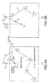
- FIG. 6A and FIG. 6B are schematic diagrams showing an example of a reroute searched for by the communication navigation terminal if a current position is off the set route.
- FIG. 6A is a schematic diagram to be displayed on the display 44 of the communication navigation terminal 5, showing that a vehicle is at a point O1 (X1, Y1), off a drive route R, and is about to return to the drive route R.
- the alphabets A, B, C, and D are guidance positions on the drive route R, preferably using an intersection, expressway entrance and exit, a service area, a parking area, and the like, which become points of a passing point.
- an alphabet E is a destination, which is far, and is usually not displayed on the display area.
- a symbol L1 shows a current traveling direction of the vehicle, and it is always upward on the display 44.
- the drive route R, the guidance positions A to D, the destination E, and the like are data inputted and recorded in the communication navigation terminal 5 when preparing the drive plan.
- the point O1 is obtained by the GPS measurement apparatus.
- a moving direction calculation method of and a moving direction presentation method of showing a reroute direction with an arrow P1 heading to the destination E (Xe, Ye) from the current position O1 (X1, Y1) are employed at the communication navigation terminal 5.
- the direction P1 is easily calculated from the coordinates (Xe, Ye) of the destination E and the coordinates (X1, Y1) of the current position O1.
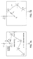
- a first modified embodiment for the reroute search will be explained with reference to FIG. 7A and FIG.7B.
- FIG. 7A is a schematic diagram to be displayed on the display 44 of the communication navigation terminal 5, showing that a vehicle is at a point O1 (X1, Y1), off a drive route R, and is about to return to the drive route R.
- the alphabets A, B, C, and D are guidance positions on the drive route R, preferably using an intersection, expressway entrance and exit, a service area, a parking area, and the like, which become points of a passing point.
- a symbol L1 shows a current traveling direction of the vehicle, and it is always upward on the display 44.
- the drive route R, the guidance positions A to D, the destination E, and the like are data inputted and recorded in the communication navigation terminal 5 when preparing the drive plan.
- the point O1 is obtained by a GPS measurement apparatus.
- a moving direction calculation method of and a moving direction presentation method of obtaining a direction heading to the closest guidance position from the current position O1 (X1, Y1) and showing a reroute direction with an arrow P2 are employed at the communication navigation terminal 5.
- a guidance position D (Xd, Yd) is the closest one to the current position
- the direction P2 is easily calculated from the coordinates (Xd, Yd) of the guidance position D and the coordinates (X1, Y1) of the current position O1.
- the targeting guidance position may be the next one of the guidance positions through which the vehicle has already passed while traveling on the route. For example, if the vehicle has passed through the guidance positions A and B and after that it deviates from the route and does not pass through the guidance position C, it is possible to perform simple navigation (instruction of the direction to be moved) to return to the guidance position C.
- a desired guidance position may be designated and inputted.
- FIG. 8A is a schematic diagram to be displayed on the display 44 of the communication navigation terminal 5, showing that a vehicle is at a point O1 (X1, Y1), off a drive route R, and is about to return to the drive route R.
- the alphabets A, B, C, and D are guidance positions on the drive route R, preferably using an intersection, expressway entrance and exit, a service area, a parking area, and the like, which become points of a passing point.
- a symbol L1 shows a current traveling direction of the vehicle, and it is always upward on the display 44.
- the drive route R, the guidance positions A to D, the destination E, and the like are data inputted and recorded in the communication navigation terminal 5 when preparing the drive plan.
- the point O1 is obtained by a GPS measurement apparatus.
- a moving direction calculation method of and a moving direction presentation method of showing a direction to reroute to the closest point on the drive route R from the current position O1 (X1, Y1) are employed at the communication navigation terminal 5.
- coordinates (X, Y) at arbitrary positions on the drive route R are sampled at predetermined intervals, and a position which has the shortest distance from the current position O1 (X1, Y1) is obtained, and the direction is shown with an arrow P3.
- the second embodiment is another method of judging whether the vehicle is within or out of the service area of a communication navigation system, and its structure and operation will be explained.
- Other structure and operation of the communication navigation system in the second embodiment are the same as those in the first embodiment described above.
- FIG. 9 is a block diagram showing a structure in the second embodiment.
- the communication navigation system in the second embodiment is established by connecting a communication navigation terminal 900 to a communication center apparatus 910 through a communication network 920.
- the communication network 920 includes the digital point-to-point communication line network 1, the digital mobile communication network 2, and the cell station 2a, which are shown in FIG. 1.
- the communication navigation terminal 900 is provided with a transmitting device 901, a receiving device 902, a test signal generator 903, a data reproducing device 904, an error detection device 905, a service area determination device 906, and an output device 907.
- the communication center apparatus 910 is provided with a receiving device 911, a transmitting device 912, and a data reproducing device 913.
- the test signal generator 903 and the error detection device 905 are elements to be newly added to the communication navigation terminal with respect to the first embodiment as a standard, and as for other constitutional elements, those in the first embodiment are available.
- the second embodiment is intended to determine whether or not the current position of a vehicle is within the service area of the communication navigation system by (i) detecting communication data quality between the communication center apparatus 910 and the communication navigation terminal 900 and (ii) determining whether or not it is possible to transmit and receive data that are sufficiently trustworthy. The procedures will be sequentially explained.
- a signal having a predetermined data row is transmitted from the test signal generator 903 of the communication navigation terminal 900 through the transmitting device 901 and the communication network 920 to the communication center apparatus 900. It is received at the receiving device 911 on the side of the communication center apparatus 910, and the received signal is reproduced at the data reproducing device 913, and then the data are transmitted back to the side of the communication navigation terminal 900 through the transmitting device 912 and the communication network 920. This is received at the receiving device 902 of the communication navigation terminal 900 and is reproduced at the data reproducing device 904. The reproduced data is inputted into the error detection device 905, and so is the data generated at and transmitted from the test signal generator 903, and they are compared with each other. It is determined at the service area determination device 906 whether or not the vehicle is within the service area according to the detection result at the error detection device 905, then outputting the result from the output device 907.
- a data row "0101010101” is generated as a test signal at the test signal generator 903 at the communication navigation terminal 900, and is then transmitted from the transmitting device 901. If all communication routes are normal, a data row received at the receiving device 911 and reproduced at the data reproducing device 913 of the communication center apparatus 910, is "0101010101" and this data is transmitted back to the communication navigation terminal 900 through the transmitting device 912 and the communication network 920. The signal that is transmitted back is received at the receiving device 902 and is reproduced at the data reproducing device 904. In the same manner, if the communication route is normal, the reproduced data row is "0101010101".
- the error detection device 905 By comparing this reproduced data row with the original data row at the error detection device 905, it is possible to detect an error generated on the whole communication route. If the data row that is transmitted back is "0111010100", then this gives the fact that two errors were generated, which makes it possible to learn the communication quality of the whole communication route including the transmitting and receiving devices.
- the result at the error detection device 905 is determined at the service area determination device 906. For example, if there is one error, it is regarded as within the service area in view of the correction capability, and the condition is determined as being possible to normally transmit and receive information between the communication navigation terminal 900 and the communication center apparatus 910.
- the display device 40 and the audio output device 50 constituting the communication navigation terminal 5 in the first embodiment can be used for the output device 907 constituting the communication navigation terminal 900.
- the CPU 22 can be used for the error detection device 905 and the service area determination device 906.
- the wireless communication device 38 can be used for the transmitting device 901 and the receiving device 902.
- the microprocessor 72 may be programmed to organize and operate each constitutional element to operate the second embodiment, which will help it realize.
- the communication navigation terminal of the present invention may be applied not for a vehicle as described in each embodiment above, but for various movable bodies such as an airplane, a ship, a bicycle, or the like. It may be further applied for those for an animal and a pedestrian, who uses a mobile phone, a mobile or hand-carry type information terminal, or the like.
Abstract
Description
- The present invention relates to a communication navigation system and a communication navigation method, which can search for a drive route (which is referred to as a "route" hereinafter as the occasion demands) to return to a preset route if a movable body such as a vehicle or the like deviates from the preset route, as well as a computer program.
- Nowadays, research and development on electronic control for controlling the drive of a vehicle are advanced, and navigation systems for aiding in driving are significantly spread and popularized. This navigation system generally has various databases and has such a basic structure that displays, on a display device, map information, current position information, various guidance information, and the like. Moreover, it searches for a drive route on the basis of an inputted condition.
- A function called as a "route search" or "path search" of a navigation apparatus mounted on a vehicle is designed to be capable of searching for an optimum route connecting an origin and a destination, both of which are designated by a user. It is also designed to lead and guide (navigate) the user to the destination by displaying on a map a current position based on a self-contained or built-in positioning measurement or a GPS (Global Positioning System) measurement and the searched optimum route.
- With respect to a traditional navigation apparatus, this kind of route search is performed by microprocessor processing in the apparatus on the basis of the map database information stored in a map information record medium (e.g. a DVD-ROM) equipped in the navigation apparatus. More concretely, the route search is executed by using "information for a route search", which enables a search for the optimum route based on predetermined mathematical algorithm, such as link information corresponding to a road part between branching points and intersections, node information including coordinates information (e.g., absolute position information on latitude and longitude, or on altitude, latitude and longitude) corresponding to the branching points and the intersections of roads or the like among the map database information. Generally, in view of its nature of being for route search, this kind of information for a route search is constructed by the link information, the node information, and the like, which are about broad areas where roads are mutually connected, for example, such as throughout Honshu or the main island of Japan, throughout Japan, or the like, so that its volume of data becomes enormous, which increases the whole amount of data of the map database information.
- Moreover, the map database information includes data of added information, which may be facility guidance information on tourist attractions / facilities, facility numerals, names (characters) of maps / roads, views of waters / railroads, and roads, in each one of many pieces of map information (drawings). These data as well as the above-described information for a route search further increase the volume of data of the map database information.
- By the way, the search for the optimum route requires the newest map database information because of changes, new constructions, and the like on roads.
- Therefore, there is a need to equip for the traditional navigation apparatus a map information record medium that stores the map database information which is the newest and whose data volume is enormous. At the same time, there is a need of the display processing and the search processing of the optimum route based on the complicated map database information. In this case, there is a need to mount a microprocessor unit (MPU), which is capable of high-speed processing, so that the scale of the processing and that of the apparatus come to increase.
- On that account, various communication navigation systems are suggested in order to improve such increase of the scale of the processing and that of the apparatus. In these communication navigation systems, the map database information is obtained and provided through two-way wireless communication between a communication center apparatus on a communication network and a communication navigation terminal mounted on a vehicle (e.g. refer to the examples of Japanese Patent Application Laying Open NO. Hei 7-262493 "a system for distributing map information for a movable body" and Japanese Patent Application Laying Open NO. Hei 10-96644 "a system for guiding a moving route").
- The communication center apparatus in the communication navigation system in this kind can quickly and cheaply provide the newest map database information, because, for example, all we need is update the map database information of one communication center apparatus to the newest information, comparing to the case of providing an information record medium, which stores the newest map database information, for an individual navigation apparatus mounted on a vehicle. Therefore, users side becomes able to receive the map database information including the newest information for a route search or the like.
- Moreover, there has been developed such a communication navigation system that is designed not to perform the route search on the side of the communication navigation terminal, but to transmit information indicating a current position or an origin and a destination on the side of the communication navigation terminal, to perform the route search according to these by a high performance processor on the side of the communication center apparatus, to receive this search result and display it in a predetermined format on the side of the communication navigation terminal and so on.
- However, the above-described communication navigation system has the following disadvantage.
- It is impossible to have a service of navigation in the area that an electric wave cannot arrive in with a sufficient electric field intensity to use a wireless device. Usually, in this situation, there is no problem while driving along a route of a preset drive plan, however, in the case of deviating from the route by some reasons, if the area is out of a service area, it becomes impossible to obtain information to return the original route. For example, if it is impossible to transmit and receive the necessary information for a route search, then it is impossible to perform a reroute search on the side of the communication navigation terminal. Alternatively, if it is impossible to receive information on a current position or the like, then it is impossible to perform the reroute search on the side of the communication center apparatus. Moreover, if it is impossible to transmit and receive the search result, there is no meaning to perform the reroute search. Particularly, a movable body communication network is placed along expressways and main highways in many cases, and once the movable body deviates from this road, it is impossible to communicate, which is sufficiently assumed. Moreover, in the current situation, the infrastructure of a communication device such as a cellular phone or the like is not sufficiently promoted in mountain areas, and even in the future, it is difficult to think of the possibility to promote the infrastructure to cover all districts including depopulated areas in the view of economic investment efficiency.
- On that account, it is extremely important to construct a device for aiding in returning to the original route and the like if a vehicle enters into the area that it cannot communicate from its communication terminal, when expanding the use of the communication navigation system.
- It is therefore an object of the present invention to provide a communication navigation system and a communication navigation method, which enable a quick return to a preset drive route in case that a movable body deviates from a route of a preset drive plan and even if the area is out of a service area of the communication navigation system, as well as a computer program.
- The above object of the present invention can be achieved by a communication navigation system provided with: a communication center apparatus; and a communication navigation terminal, both of which transmit and receive information by a two-way communication through a communication network, (i) the communication center apparatus provided with: a map database for storing therein map database information including information for a route search, which enables the route search from a current position of a movable body to a destination by a predetermined algorithm; a search device for searching, by the predetermined algorithm, for a route heading to the destination from the current position, on the basis of the map database information including the information for the route search, from the destination and the current position received through the communication network; and a center side wireless device for wirelessly transmitting route information indicating the searched route through the communication network, (ii) the communication navigation terminal provided with: a measurement device for measuring the current position; a terminal side wireless device for transmitting the measured current position and receiving the transmitted route information through the communication network; and a route navigation device for selectively performing a route navigation on the searched route on the basis of the measured current position and the received route information or performing a simple navigation with a lower accuracy than that of the route navigation on a route other than the searched route on the basis of the measured current position.
- According to the communication navigation system of the present invention, the communication center apparatus is provided with the map database. This map database stores large-scale map database information including the information for the route search such as the above-described node information, link information, or the like, which enables a search for an optimum route from an origin to a destination by a predetermined mathematical algorithm such as Dijkstra's algorithm and so on. When the communication navigation is performed, the route search request information indicating an origin and a destination may be firstly transmitted by a user communication terminal such as a cellular phone, a mobile, a facsimile, a personal computer, or the like at a user's home, a communication navigation terminal, which is carried by a user or which is mounted on a user's movable body, and so on. Secondly, the communication center apparatus receives this information through the communication network. Then, at the communication center apparatus, the search device searches for the optimum route with respect to the received route search request information with the predetermined algorithm such as Dijkstra's algorithm or the like on the basis of the information for the route search included in the above-described map database information. Then, the center side wireless device wirelessly transmits, through the communication network, the searched route information, including the information on a plurality of guidance positions, for example, such as a branching point, an intersection, or the like, located on this searched route. In this specification, the "guidance position" is referred to a position at which it is preferable to perform the route navigation or the route guidance of some kind in order to drive on a predetermined route. Moreover, the " information on guidance positions" is information that allows the specification of locations of the guidance positions somehow, such as coordinates information that indicates absolute locations of the guidance positions, coordinates information that indicates relative locations with the absolute location as a standard, and the like.
- On the side of the communication navigation terminal, the terminal side wireless device receives the route information indicating the optimum route from the current position to the destination, which has been transmitted from the center side wireless device of the communication center apparatus. This route information is recorded in the communication navigation terminal, and it is read out and displayed when the route navigation device performs the route navigation. Map information for display used in this case can be obtained such that when the optimum route is presented from the communication center apparatus, the related map information within a predetermined range is transmitted at the same time. In this case, the map information for display can decrease in the volume of data to be transmitted and received, by cutting the related information within a predetermined range from the map database information including the information for the route search, whose data volume is huge, and transmitting it, and thus a recording device of the communication navigation terminal may be small. Alternatively, if the simple map information having small data volume is available, the map information may be stored in a storing device such as a DVD or the like equipped for the communication navigation terminal, and a related part may be read out from this.
- Moreover, the communication navigation terminal is provided with a measurement device for measuring the current position. This is constructed by, for example, a GPS measurement device or a self-contained or built-in positioning apparatus for detecting a velocity, an acceleration velocity, an angular velocity, and the like, which is mounted on the movable body.
- Especially, here, the route navigation device, which is provided for the communication navigation terminal, selectively performs the route navigation on the optimum route, on the basis of the measured current position and the route information indicating the optimum route from the current position to the destination, which has been received by the terminal side wireless device as described above. For example, a current position mark of the self-car is displayed on the optimum route which is highlight-displayed on a map, and the guidance information is displayed or audio-outputted at each intersection on the optimum route. Then, the route navigation on the optimum route in this kind is continued, as long as the self-car keeps a normal drive on the route.
- On the other hand, the route navigation device, which is provided for the communication navigation terminal, selectively performs the simple navigation with a lower accuracy than that of the route navigation, which obeys the route information generated at the search device of the communication center apparatus described above, on a route other than the optimum route, on the basis of the measured current position. For example, a current position mark of the self-car may be displayed with a direction to be moved at a position out of the optimum route which is highlight-displayed on a map (a position not limited to on a road), and/or the guidance information roughly on which azimuth to be moved may be displayed or outputted. Then, this type of situation occurs in the case of deviating from the route by some reasons, and this simple navigation is continued until the self-car returns to the optimum route or the new route information is obtained from the communication center apparatus.
- Incidentally, whether to perform the route navigation or to perform the simple navigation by the route navigation device may be automatically chosen by detecting whether or not to be off the route or by judging whether to be within the service area in which the communication by the communication network is possible or out of the service area where the communication by the communication network is impossible. Alternatively, it may be constructed to make this kind of choice with a manual operation of the communication navigation terminal, in view of cost increase because of the access to the communication center apparatus and the like.
- Consequently, in the case of deviating from the optimum route by some reasons when moving along the optimum route made at the communication center apparatus, and even if the position is out of the service area of the communication navigation system, it is possible to relatively quickly return to the planned optimum route by the simple navigation or head to the destination relatively correctly. In contrast, if it is within the service area, even in the case of deviating from the optimum route, it is possible to obtain the route information to return to the optimum route or the route information indicating a new optimum route to the destination (i.e. "reroute search" is possible), by communicating between the communication center apparatus and the communication navigation terminal.
- As described above, the present invention, in which the communication navigation terminal mounted on the movable body is simply constructed with essential functions, is intended to search for a route to the destination on the basis of data in the communication navigation terminal, even if the movable body goes out of the service area of the communication navigation system, in which the searching and operating functions in high quality requiring time are installed at the communication center apparatus.
- Incidentally, as a concrete method of the simple navigation by the route navigation device, the direction of the movable body to be moved, such as a direction heading to the closest position on the optimum route to the current position, a direction heading to the destination from the current position, a direction heading into the service area from the current position, and the like may be displayed or audio-outputted. Alternatively, by using the map information for display, the simple route search operation with a lighter processing burden than that of the route search performed by the search device of the communication center apparatus may be performed. In any cases, the simple navigation can use the microprocessor unit, which is installed for the communication navigation terminal to control the system, and does not require a special operation apparatus.
- As described above, at the communication navigation terminal, the route information related to the optimum route is preferably received and recorded with the map information for display related to this in order to perform the simple navigation such as the decision of the direction of the movable body to be moved and the like. Moreover, it may be displayed or audio-outputted in addition to the simple map information recorded in the DVD or the like and the map information recorded and transmitted from the communication center apparatus for the route navigation by the route information related to the optimum route from which the movable body has already deviated, in the simple navigation.
- In one aspect of the communication navigation system of the present invention, the route navigation device performs the route navigation in case that the movable body is on the searched route.
- According to this aspect, in case that the movable body is on the searched route, the route navigation is selectively performed by the route navigation device. Namely, as long as the movable body moves on the optimum route, the typical route navigation using the communication network is performed.
- In another aspect of the communication navigation system of the present invention, the route navigation device performs the simple navigation out of a service area of the communication navigation system, in which it is hardly or not possible to transmit and receive the information through the communication network, in case that the movable body is not on the searched route.
- According to this aspect, in case that the movable body is not on the optimum route, the simple navigation is selectively performed by the route navigation device out of the service area. In this situation, it is impossible to perform the typical route navigation on the optimum route. However, this is not like the conventional technique that any navigation cannot be performed because of the impossibility of the communication navigation system out of the service area, and instead, the simple navigation is performed, which is extremely useful in practice.
- Incidentally, the term " in case that the movable body is not on the searched route" in this specification includes the case that the movable body deviates from the searched route during the drive by some reasons and the case that the searched route does not exist because it is at the start of the drive or at the beginning of the startup of the communication navigation system and the route search has never been performed.
- In another aspect of the communication navigation system of the present invention, the route search is required of the communication center apparatus by the terminal wireless device within a service area of the communication navigation system, in which it is possible to transmit and receive the information through the communication network, in case that the movable body is not on the searched route.
- According to this aspect, in case that the movable body is not on the searched route, the terminal side wireless device requires the route search of the communication center apparatus within the service area. Therefore, in response to this, the reroute search is performed by the search device on the side of the communication center apparatus and the route information is generated. Then, this is received at the communication navigation terminal and the route navigation is performed. Namely, if within the service area, the reroute search with a high accuracy is performed through the communication network by making the best use of the benefit of the communication navigation system, which is useful.
- In another aspect of the communication navigation system of the present invention, the communication navigation terminal is further provided with a judgment device for judging whether the current position is within or out of the service area.
- According to this aspect, in case that the movable body goes out of the service area of the communication navigation system, in response to that, it becomes possible to appropriately deal with the route navigation, the simple navigation, the route search, and the like by automatic or manual operations.
- In another aspect of the communication navigation system of the present invention, the judgment device judges on the basis of an electric field intensity of an electric wave received by the terminal side wireless device.
- According to this aspect, if the electric field intensity level of the electric wave received by the terminal side wireless device of the communication navigation terminal is low and information cannot be received in sufficient quality, it is judged out of the service area of the communication navigation. If judged out of the service area, it is possible to automatically reflect the fact to the choice at the route navigation device in case of deviating from the route later, or it is possible to inform the fact of a driver by displaying it on the display device of the communication navigation terminal, alarming with a speaker, or the like.
- In another aspect of the communication navigation system of the present invention, the judgment device judges by transmitting a predetermined data row to the communication center apparatus from said communication navigation terminal, restoring the received data row at the communication center apparatus and transmitting it back to the communication navigation terminal, and then comparing the received data row with the transmitted data row at the communication navigation terminal.
- According to this aspect, the communication navigation terminal judges whether the current position is within or out of the service area by emitting a signal for checking to the communication center apparatus, receiving and analyzing a signal for replying to be transmitted, and judging whether or not the communication quality is sufficient. For example, it transmits predetermined data and has the communication center apparatus transmitted the data back. After receiving the data, it compares the transmitted data with the received data to obtain the frequency of errors and judges whether the current position is within or out of the service area. In this manner, it is possible to judge whether or not it is possible to have the service in the total communication system including the condition of the communication center apparatus in addition to the condition of the wireless communication network, which becomes a communication medium.
- In another aspect of the communication navigation system of the present invention, a judgment of the judgment device is performed at a predetermined time interval.
- According to this aspect, the terminal side wireless device of the communication navigation terminal receives a carrier wave of a wireless line at predetermined time intervals and monitors its electric field intensity while the movable body is driving. If the electric field intensity level is equal to or lower than a predetermined level, it is judged out of the service area.
- In another aspect of the communication navigation system of the present invention, a judgment of the judgment device is performed at a predetermined driving distance interval.
- According to this aspect, the terminal side wireless device of the communication navigation terminal receives a carrier wave of a wireless line and monitors its electric field intensity every time the movable body drives a predetermined distance while the movable body is driving. If the electric field intensity level is equal to or lower than a predetermined level, it is judged out of the service area. According to this method, it becomes possible to omit the operation of judgment regardless of the case of rarely driving because of traffic congestion. Moreover, it becomes possible to sufficiently understand the first driving distance after the movable body goes out of the service area.
- In another aspect of the communication navigation system of the present invention, the communication navigation terminal is further provided with a choice device for choosing whether to require the route search of the communication center apparatus by the terminal side wireless device or to perform the simple navigation by the route navigation device in case that the movable body is not on the searched route.
- According to this aspect, in case that the movable body is not on the searched route, i.e. in the case of deviating from the route by some reasons or in the case of being at the start of the drive when the route search has not been performed, the user such as a driver or the like uses the choice device and thus the user can choose whether to require the route search with the use of the communication network or perform the simple navigation without the use of it. On that account, it is possible to control on the user's will cost increase and the like happened by the access to the communication center apparatus and the used of the communication network, which is useful in practice.
- In another aspect of the communication navigation system of the present invention, the communication navigation terminal is further provided with a detection device for detecting whether or not the current position is on the searched route.
- According to this aspect, it is detected by the detection device whether or not the current position of the movable body is on the optimum route to have planned. If it is on the optimum route, the drives continues according to the plan. On the other hand, if it is not on the optimum route, the search to return to the route to have planned is performed according to the predetermined algorithm described above by automatic or manual operations. Here, for example, by sequentially comparing the latitude and the longitude of the planned optimum route with those measured on the basis of the recorded route information and the position information measured by a GPS measurement or the like, it is possible to learn whether or not the current position is off the planned optimum route. Moreover, it is possible to obtain the moving direction to return to the planned route from the current position and a predetermined position of the planned optimum route, for example, the latitude and the longitude of the destination. In either way of the case that those latitude and longitude are absolute or the case that they are relative with a predetermined point as a standard, they can be used to realize the present invention.
- In another aspect of the communication navigation system of the present invention, the route navigation device displays or audio-outputs a direction of the movable body to be moved, on the basis of the current position as the simple navigation.
- According to this aspect, when the simple navigation is performed by the route navigation device, the direction of the movable body to be moved is displayed on a map picture or audio-outputted from a speaker in the vehicle, on the basis of the current position. For example, it is possible to use various forms, which can be easily and visually confirmed, for example, such as an arrow heading to the destination from the current position (the destination here is not limited to a final position of arrival but includes an arbitrary position on the route), a blinking optical row, and the like. Alternatively, composite audio output such as "go back on the left" and the like may be performed. Because of this, it is possible to quickly return to the original optimum route or head to the destination even if out of the service area.
- In this aspect of displaying this direction to be moved or the like, the route navigation device may display or audio-output a direction heading to the destination from the current position as the direction to be moved.
- By constituting in this manner, the moving direction of the movable body is calculated on the basis of data of the current position of the movable body and position data of the final destination, and the direction is displayed with the map information.
- Alternatively, in this aspect of displaying the direction to be moved or the like, the route navigation device may display or audio-output a direction heading to a guidance position, which is the closest to the current position from among a plurality of guidance positions on the searched route, from the current position as the direction to be moved.
- By constituting in this manner, the moving direction of the movable body is calculated on the basis of the data of the current position of the movable body and the position data of a guidance position, which is the closest to the current position from among a plurality of guidance positions on the route, and the direction is displayed with the map information.
- Alternatively, in this aspect of displaying the direction to be moved or the like, the route navigation device may display or audio-output a direction heading to a guidance position, which is the next one of a last passed guidance position from among a plurality of guidance positions on the searched route, from the current position as the direction to be moved.
- By constituting in this manner, the moving direction of the movable body is calculated on the basis of the data of the current position of the movable body and the position data of the next one of the last passed guidance position from among a plurality of guidance positions on the route, and the direction is displayed with the map information.
- Further alternatively, in this aspect of displaying the direction to be moved or the like, the route navigation device may display or audio-output a direction heading to a position, which is the closest to the current position on the searched route, from the current position as the direction to be moved.
- According to this aspect, the moving direction of the movable body is calculated on the basis of the data of the current position of the movable body and the position data of the position closest to the current position on the driving route, and the direction is displayed with the map information.
- Incidentally, in these aspects of displaying the direction to be moved described above, there are, for example, latitude and longitude as the position data, and they may be absolute values or relative values with a predetermined point as a standard. By choosing and driving on a road along to the direction to be displayed by this, it is possible to return to the set driving route for a relatively short period of time.
- In another aspect of the communication navigation system of the present invention, the route navigation device searches for a route of the movable body to be moved on the basis of the current position and map information stored in the communication navigation terminal, as the simple navigation.
- According to this aspect, the route navigation device does not display or audio-output an azimuth to be moved, but searches for a route to be moved. This type of route search is performed on the basis of the current position and the map information stored in the communication navigation terminal. It does not have to be in a high quality, which is usually necessary at the communication center apparatus, and it only needs what is enough to return into the service area or return to the route from which the movable body has been deviated from.
- In another aspect of the communication navigation system of the present invention, it is further provided with a user communication terminal for performing the two-way communication on the communication network, the user communication terminal being capable of transmitting the destination to the communication center apparatus.
- According to this aspect, the user communication terminal, such as a personal computer, a facsimile, a mobile, a cellar phone, and the like, which are installed at the user's home, transmits the route search request information, and the center side wireless device receives this route search request information. Since the route that meets the condition presented by the user is searched for on the basis of this information at the communication center apparatus, it becomes possible to request the route search before the user actually starts moving. The searched route information may be transmitted or transported to the communication navigation terminal through the wireless communication device directly from the communication center apparatus. It may also be transported to the communication navigation terminal after stored in the user communication terminal once. The transportation to the communication navigation terminal from the user communication terminal may be performed with a wireless device or through a memory medium such as a magnetic record medium, a semiconductor memory, or the like.
- The above object of the present invention can be achieved by a communication navigation terminal included in the above described communication navigation system (including its various aspects).
- According to the communication navigation terminal of the present invention, it is possible to establish the above described communication navigation system of the present invention by the use of this with the communication center apparatus and the communication network related to the present invention as described above. Moreover, even if it connects a lot of communication navigation terminals to the same communication center apparatus, respective one of the communication navigation terminals in this kind can benefit from the communication navigation system.
- The above object of the present invention can be achieved by a first computer program, which may be stored in a program storage device readable by a computer, or which may be carried as a computer data signal by a carrier wave. The computer program performs method processes of communication navigation at the communication navigation terminal in the above-described communication navigation system (including its various aspects), more concretely, at various component devices, such as the measurement device, the terminal side wireless device, the route navigation device, and the like, which constitute the communication navigation terminal of the present invention.
- According to the first computer program of the present invention, the above described communication navigation terminal of the present invention can be relatively easily realized as a computer reads and executes the program of instructions from the program storage device such as a CD-ROM (Compact Disc - Read Only Memory), a DVD-ROM (DVD Read Only Memory), a hard disc or the like, or as it executes the program of instructions after downloading the program through communication device.
- The above object of the present invention can be also achieved by a second computer program, which may be stored in a program storage device readable by a computer, or which may be carried as a computer data signal by a carrier wave. The computer program of instructions performs method processes of communication navigation in the above described communication navigation system (including its various aspects), more concretely, on one hand, at various constitutional elements, such as the map database, the search device, the center side wireless device, and the like, which constitute the communication center apparatus, and on the other hand, at various constitutional elements, such as the measurement device, the terminal side wireless device, the route navigation device, and the like, which constitute the communication navigation terminal of the present invention.
- According to the second computer program of the present invention, the above described communication navigation system of the present invention can be relatively easily realized as a computer reads and executes the program of instructions from the program storage device such as a CD-ROM, a DVD-ROM, a hard disc or the like, or as it executes the program of instructions after downloading the program through communication device. For example, the communication navigation terminal may be constructed such that it has a browser function and that the computer program to use is substantially or partially provided from the side of the communication center apparatus, as the occasion demands.
- Incidentally, the above object of the present invention can be achieved by another computer program, which may be stored in a program storage device readable by a computer, or which may be carried as a computer data signal by a carrier wave. The computer program of instructions performs method processes of communication navigation at a communication center apparatus included in the above described communication navigation system of the present invention (including its various aspects), more concretely, at various constitutional elements, such as the map database, the search device, the center side wireless device, and the like, which constitute the communication center apparatus.
- The above object of the present invention can be achieved by a communication navigation method executed in a communication navigation system comprising: a communication center apparatus; and a communication navigation terminal, both of which transmit and receive information by a two-way communication through a communication network, the method comprising: (i) at the communication center apparatus, a search process of searching, by a predetermined algorithm, for a route heading to a destination from a current position, from the destination and the current position received through the communication network, on the basis of a map database for storing therein map database information including information for a route search, which enables the route search from the current position of a movable body to the destination by the predetermined algorithm; and a center side wireless process of wirelessly transmitting route information indicating the searched route through the communication network, and (ii) at the communication navigation terminal, a measurement process of measuring the current position; a terminal side wireless process of transmitting the measured current position and receiving the transmitted route information through the communication network; and a route navigation process of selectively performing a route navigation on the searched route on the basis of the measured current position and the received route information or performing a simple navigation with a lower accuracy than that of the route navigation on a route other than the searched route on the basis of the measured current position.
- According to the communication navigation method of the present invention, as is the case with the above described communication navigation system of the present invention, in the case of deviating from the optimum route by some reasons when moving along the optimum route made at the communication center apparatus, and even if the position is out of the service area of the communication navigation system, it is possible to relatively quickly return to the planned optimum route by the simple navigation or head to the destination relatively correctly. In contrast, if it is within the service area, even in the case of deviating from the optimum route, it is possible to obtain the route information to return to the optimum route or the route information indicating a new optimum route to the destination, by communicating between the communication center apparatus and the communication navigation terminal.
- The nature, utility, and further features of this invention will be more clearly apparent from the following detailed description with reference to preferred embodiments of the invention when read in conjunction with the accompanying drawings briefly described below.
-
- FIG. 1 is a block diagram showing the whole structure of a communication navigation system in a first embodiment of the present invention;
- FIG. 2 is a block diagram showing an example of the inner structure of a communication navigation terminal shown in FIG. 1 in the first embodiment;
- FIG. 3 is a block diagram showing an example of the inner structure of a communication center apparatus shown in FIG. 1 in the first embodiment;
- FIG. 4 is a flow chart showing operational flows in the first embodiment;
- FIG. 5 is a sequence chart showing with time the relationship among a driver, the navigation terminal, and the communication center, with respect to the operational flows in the first embodiment;
- FIG. 6A and FIG. 6B are schematic diagrams showing an example of a reroute searched for by the communication navigation terminal if a current position is off the set route, in the first embodiment;
- FIG. 7A and FIG. 7B are schematic diagrams showing a first modification example of a reroute searched for by the communication navigation terminal if a current position is off the set route, in the first embodiment;
- FIG. 8A and FIG. 8B are schematic diagrams showing a second modification example of a reroute searched for by the communication navigation terminal if a current position is off the set route, in the first embodiment; and
- FIG. 9 is a block diagram showing a structure to check communication quality in a second embodiment.
-
- Referring to the accompanying drawings, embodiments associated with a communication navigation system and a communication navigation method, a program storage device, and a computer data signal embodiment in a carrier wave of the present invention will be now explained. Incidentally, each embodiment, which will be described below, is intended to establish the communication navigation system of the present invention as a system that enables an easy return to a preset route out of the service area of the communication navigation system by using the communication center apparatus and operating the communication navigation terminal mounted on a vehicle.
- Firstly, the whole structure of the communication navigation system in the first embodiment will be explained with reference to FIG. 1. FIG. 1 is a block diagram showing the whole structure of the communication navigation system in the first embodiment.
- In FIG. 1, a digital point-to-point
communication line network 1 and a digital mobile communication network 2 (hereunder, the two communication networks are collectively referred to as a "communication line network" as the occasion demands), both of which are connected to each other by a gateway (GW) device for communication protocol conversion, are provided in the first embodiment. On this communication line network, IP (Internet Protocol) packet communication is performed under the TCP / IP (Transmission Control Protocol /Internet Protocol) environment (e.g. the Internet). - The digital point-to-point
communication line network 1 is connected to acommunication center apparatus 3 for a communication navigation company, a personal computer or the like installed at a user's home as one example of a communication terminal 4 for users. - At a
cell base station 2a of the digitalmobile communication network 2, a cellular phone, a mobile or hand-carry type information terminal / PDA (Personal Digital Assistants), and the like as other examples of the communication terminal 4 are accommodated and further an on-vehiclecommunication navigation terminal 5 mounted on the user's vehicle is accommodated through a wireless section (air interface). - The
communication center apparatus 3 is constructed to perform maintenance and preservation, which have been traditionally performed at an on-vehicle navigation apparatus, of the newest map database information including the map information for display of various scales, the information for the route search, and the like, which have enormous data volume. Moreover, it is designed to perform the search processing of the optimum route, whose load of processing is heavy, in place of the on-vehicle navigation apparatus. - The communication terminal 4 is constructed to request the
communication center apparatus 3 to provide the map information, to search for the optimum route, and so on. Moreover, it is constructed to give instructions of where to transmit the requested map information or the like. Incidentally, the request and the instruction of where to transmit described above can be performed from thecommunication navigation terminal 5 in the same manner as those from the communication terminal 4. - The
communication navigation terminal 5 is for vehicle use, downloads the map information for display that is minimally required for display from among the map database information of thecommunication center apparatus 3 at least when displaying a map during a navigation operation, and is equipped with a record medium, such as a CD, a DVD for storing the map information for display or the like. Then, along with screen-displaying the road map by using the map information for display in this kind, it displays the optimum route to a destination, a location of a vehicle, a moving direction, scale circle / radius, a driving locus, a map direction or orientation, and the like - The
communication center apparatus 3, the communication terminal 4, and thecommunication navigation terminal 5 are equipped with a communication application program (e.g. Web browser), which will be explained in detail later. - Incidentally, the communication network in FIG. 1 is not especially limited to the TCP / IP method, and various data communication methods are available. It also allows the use of an analog point-to-point communication line network instead of the digital point-to-point
communication line network 1. - Next, the
communication navigation terminal 5 shown in FIG. 1 will be further explained with reference to FIG. 2. FIG. 2 is a block diagram showing an example of the inner structure of thecommunication navigation terminal 5 shown in FIG. 1. - In FIG. 2, this
communication navigation terminal 5 is provided with a self-containedpositioning apparatus 10, aGPS receiver 18, asystem controller 20, an input and output (I/O)circuit 21, a CD-ROM drive 31, a DVD-ROM drive 32, a hard disk device (HDD) 36, awireless communication device 38, adisplay device 40, anaudio output device 50, aninput device 60, and an outer interface (I/F)device 61. Each component is connected to abus line 30 for transmitting processing data and control data. - Especially in this embodiment, the
wireless communication device 38 constructs one example of a terminal-side wireless device, and thedisplay device 40 constructs one example of a route guidance device with thesystem controller 20 or the like. - The self-contained
positioning apparatus 10 is constructed by anacceleration sensor 11, an angular velocity sensor 12, and avelocity sensor 13. Theacceleration sensor 11, which is constructed by a piezoelectric element, for example, outputs acceleration data obtained by detection of the acceleration of a vehicle. The angular velocity sensor 12, which is constructed by a vibration gyro, for example, outputs angular velocity data and relative azimuth data obtained by detection of the angular velocity of a vehicle when the vehicle changes its moving direction. Thevelocity sensor 13 detects the rotation of a vehicle shaft mechanically, magnetically, or optically and outputs signals of the number of pulses corresponding to a vehicle speed at every rotation for a predetermined angle around a vehicle shaft. - The
GPS receiver 18 has a known structure, provided with a memory, a microprocessor unit (MPU), a digital signal processor unit (DSP) or the like, as well as a high frequency reception processing device and a plane polarization non-directional receiving antenna. TheGPS receiver 18 is constructed to receive electric waves Wa to Wc (when desired to obtain more reliable values, four electric waves Wa to Wd) from at least three GPS satellites placed into the orbit around the earth, to perform the inverse-diffusion of spectra, the distance measurement, the Doppler measurement, and the orbital data processing, and to continuously output absolute position information of a reception position (a driving position of a vehicle) from the I/O circuit 21 to thebus line 30 after the calculation of a moving velocity/azimuth and the calculation of a location. Thesystem controller 20 takes in the calculation result and screen-displays it on the map road. - The
system controller 20 is constructed by a CPU (Central Processing Unit) 22, a ROM (Read Only Memory) 23, which is a non-volatile solid storage element, and a RAM (Random Access Memory) 24, for working and exchanges data with each component connected to thebus line 30. The processing control by this exchange of data is executed by a control program and a boot program stored in theROM 23. TheRAM 24 temporarily stores setting information, which changes map display (e.g., changes it to a full-scale or local map display) by the user's operation from theinput device 60, especially. - The CD-
ROM drive 31 and the DVD-ROM drive 32 read out from a CD-ROM 33 and a DVD-ROM 34 respectively and output the map database information (e.g., various road data, such as a road width, the number of traffic lanes, or the like, on map information (drawings)), which is stored in both the CD-ROM 33 and the DVD-ROM 34. - Incidentally, it is possible to install either one of the CD-
ROM drive 31 and the DVD-ROM drive 32, and it is also possible to install one compatible drive. - The
hard disk device 36 can store map (image) data, which are read in at the CD-ROM drive 31 or the DVD-ROM drive 32, and after this storing, it can read out them at an arbitrary time. Thehard disk device 36 can further store video data and audio data, both of which are read in from the CD-ROM drive 31 and the DVD-ROM 32. Because of this, for example, it becomes possible to read out the video data and the audio data stored in thehard disk device 36 and output them as video and as sound or voice, while reading out the map data on the CD-ROM 33 and the DVD-ROM 34 to perform the navigation operation. Alternatively, it becomes possible to read out the map data stored in thehard disk device 36 to perform the navigation operation, while reading out the video data and the audio data on the CD-ROM 33 and the DVD-ROM 34 and outputting them as video and as sound. Moreover, it becomes possible, by storing into thehard disk device 36 the map data, the video data, or the audio data, which are downloaded by thewireless communication device 38, to read and output them at an arbitrary time. - The
wireless communication device 38 has the same structure as that of a general-purpose cellular phone, which is known as TDMA, TDD, or CDMA structure (a high-frequency wireless transmitting / receiving device, an encoding / decoding device, a time division multiplexing device, a control device, an audio input / output device, and the like) in the manner of PDC (Personal Digital Cellular Telecommunication System) or PHS (Personal Handyphone System), for example. - The
display device 40 screen-displays various processing data under the control of thesystem controller 20. Agraphic controller 41 inside thedisplay device 40 controls each component of thedisplay device 40 on the basis of the control data transmitted from theCPU 22 through thebus line 30. Moreover, abuffer memory 42 using the V-RAM or the like temporarily memorizes immediately-displayable image information. Furthermore, along with adisplay control device 43 controlling display, adisplay 44, which is constructed by a liquid crystal display (LCD), an EL (Electro-Luminescence), or a CRT (cathode-ray tube), screen-displays the image data outputted from thegraphic controller 41. Thisdisplay 44 is installed in the vicinity of a front panel in a vehicle, for example. - At the
audio output device 50, a D/A converter 51 performs a digital to analog conversion on an audio signal transmitted through thebus line 30 under the control of thesystem controller 20. A variable amplifier (AMP) 52 variably amplifies the audio analog signal outputted from the D/A converter 51, and outputs it to aspeaker 53, from which it is audio-outputted, - The
input device 60 is provided with a key, a switch, a button, a remote controller, an audio input device, and so on, to input various types of commands and data. Theinput device 60 is installed in the vicinity of thedisplay 44 or a front panel of a main body of the on-vehicle navigation system mounted on the vehicle. - Incidentally, the
communication navigation terminal 5 is not limited to the above-described structure. For example, theGPS receiver 18 is built in thecommunication navigation terminal 5 and is wired and connected to the I/O circuit 21 in the above-described structure. However, it is also possible to employ such a structure that a general-purpose mobile or hand-carry type GPS receiver is wired and connected (interface connected) to the outer I/F device 61. It is also possible to employ such a wireless connection manner that a weak radio transmitting/ receiving device (e.g. Bluetooth frequency hopping communication manner) is installed to the general-purpose mobile or hand-carry type GPS receiver at the outer I/F device 61. - In the same manner as the
GPS receiver 18 does, thewireless communication device 38 can also employ such a structure that a general-purpose mobile or hand-carry type cellular phone is wired and connected (interface connected) to the outer I/F device 61. It is also possible to employ a wireless connection manner that a weak radio transmitting/ receiving device is installed to the general-purpose mobile or hand-carry type cellular phone at the outer I/F device 61. - Moreover, the
input device 60 can also employ an infrared ray remote control manner and/or the same weak radio transmission / reception manner as those of thewireless communication device 38 and theGPS receiver 18. The infrared ray remote control manner is designed such that it uses a remote controller to perform infrared ray remote manipulation by user's hands, with an infrared ray reception device and a decoder built in the communication navigation terminal 5 (in general, they are installed in the vicinity of the display 44). - Next, the
communication center apparatus 3 shown in FIG. 1 will be further explained with reference to FIG. 3. FIG. 3 is a block diagram showing an example of the inner structure of thecommunication center apparatus 3. - In FIG. 3, this
communication center apparatus 3 is provided with aline connecting device 71, amicroprocessor 72, acommunication control device 73, a map information processing database (D/B)device 74, a mapinformation reading device 75, amemory device 76, an interface (I/F)device 77, a DVD-ROM 78 (a CD-ROM is also available), acommunication terminal 79, atimer circuit 82, and abus line 90. - Especially in this embodiment, the
communication control device 73 constitutes one example of a center side wireless device, and the map informationprocessing database device 74 constitutes one example of a search device. - The
line connecting device 71 is intended to accommodate thecommunication center apparatus 3 in the digital point-to-pointcommunication line network 1, and it is provided with a DSU (Digital Service Unit), which is a terminating device, a router, a firewall, and the like, for example. Incidentally, theline connecting device 71 is equipped with a network control unit (NCU), a modulator-demodulator (modem), and the like in the case of using an analog point-to-point communication line network instead of the digital point-to-pointcommunication line network 1 in FIG. 1. - The
microprocessor 72 is provided with a ROM, a working RAM, and a CPU. Thecommunication center apparatus 3 controls each component on the basis of a program, and its control data and processing data are exchanged through thebus line 90. Themicroprocessor 72 further works with the map informationprocessing database device 74 to execute various data processing such as the search processing of the optimum route or the like, which will be explained later. - The
communication control device 73 works with theline connecting device 71 to execute the communication protocol with the communication line network. For example, it executes the TCP/ IP. - The map information
processing database device 74 stores the map database information including the map information for display of various scales, the information for the route search constructed by the link information, the node information, and the like, which have enormous data volumes and which cover road networks spread in a broad area such as throughout Honshu or the main island of Japan or throughout Japan and so on. Moreover, the map informationprocessing database device 74 uses this map database information to execute data processing, such as the search processing of the optimum route or the like, with themicroprocessor 72. - The map
information reading device 75 operates as a drive, which reads out the map database information from the CD-ROM or DVD-ROM 78. The map database information from the CD-ROM or DVD-ROM 78 is transmitted to and stored into the map informationprocessing database device 74 through thebus line 90. The map database information at the map informationprocessing database device 74 is updated by reading out data from the CD-ROM or DVD-ROM 78, which stores the newest map database information. - The
memory device 76 holds information on setting an apparatus and a variable in control processing of themicroprocessor 72 transmitted through thebus line 90. - The I/
F device 77 accommodates an outer LAN (Local Area Network) to execute the information processing and maintenance of various types such as replacement of the map database information at the mapinformation reading device 75. - The
communication terminal 79 is intended to take in the map database information instead of the CD-ROM or DVD-ROM 78. For example, it is intended to on-line-download (receive) the map database information provided from a map information preparing organization to install it into the map informationprocessing database device 74. Therefore, the map database information at the map informationprocessing database device 74 may be updated through thecommunication terminal 79. - Incidentally, in the case that this
communication center apparatus 3 is used as the Internet, it will be a portal site structure. For example, it is provided with a Web server, a FTP (File Transfer Protocol) file transmitting server, a DNS (Domain Name System) server, a FAX / e-mail server, and so on. - A cellular phone as the communication terminal 4 shown in FIG. 1 also has a structure known as the PDC manner and the PHS manner (TDMA, TDD, or CDMA). A PDA or a compact general-purpose computer as the communication terminal 4 also has a familiar structure operation, and each detailed explanation will be omitted. The cellular phone as the communication terminal 4 is equipped with an application (an exclusive browser) for browsing contents of exclusive HTML (Hypertext markup language) tag description, which is accessible to the Internet. Moreover, the PDA or the compact general-purpose computer is also equipped with an application (browser / mailer application program) accessible to the Internet, which is a known structure.
- Especially in the first embodiment having the structure to have described with reference to FIG. 1 to FIG. 3, the
communication center apparatus 3 performs the route search, which has been traditionally performed inside the on-vehicle navigation apparatus, by themicroprocessor 72 and the map information procession D/B device 74. Then, it provides thecommunication navigation terminal 5 with the route information including the optimum route obtained as the result of the route search. - The communication terminal 4 is constructed to give instructions of where to transmit the information for the route search as well as requesting the route search of the
communication center apparatus 3. Incidentally, these kinds of route search requests and instructions of where to transmit can be performed from thecommunication navigation terminal 5 in the same manner as those from the communication terminal 4. - The
communication navigation terminal 5 uses the route information wirelessly transmitted from thecommunication center apparatus 3 to perform route display on a map road. Moreover, at thecommunication navigation terminal 5, it is also possible to perform route guidance of right turn, left turn, straight advance, or the like at each guidance position according to the route guidance information on the each guidance position on the route transmitted with the route information. With respect to the route guidance information in this kind, it is not necessary to wirelessly transmit it with the route information. It is also possible to otherwise produce the route guidance information in this kind on the basis of the route information received on the side of thecommunication navigation terminal 5. - Especially in this embodiment, the map information
processing database device 74 of thecommunication center apparatus 3 stores the map database information whose data volume is enormous and which includes a wider variety of information than the map data stored in the CD-ROM 33, the DVD-ROM 34, theHDD 36, or the like of thecommunication navigation terminal 5. Namely, the map database information including the map information for display of various scales, the information for the route search constructed by the link information, the node information, and the like, which cover road networks spread in a broad area such as throughout Honshu or the main island of Japan or throughout Japan and so on. Moreover, this map database information includes data of added information, for example, such as map scales, guidance information of tourist attractions / facilities, facility numerals and the name (characters) of maps / roads, views of waters / railroads, and roads, on each map. Among them, especially the information for the route search enables the route search based on the predetermined mathematical algorithm such as Dijkstra's algorithm or the like, and its data volume becomes enormous. - Furthermore, the search processing, which has the heavy load of processing based on the information for the route search having this enormous data volume, is not performed on the side of the
communication navigation terminal 5 but is executed on the side of thecommunication center apparatus 3 by the map informationprocessing database device 74 and themicroprocessor 72. - As described above, the CD-
ROM 33, the DVD-ROM 34, theHDD 36, and the like of thecommunication navigation terminal 5 do not store the information for the route search whose data volume is enormous, and their memory capacities are far smaller than that necessary for the map informationprocessing database device 74, which is advantageous in view of simplifying thecommunication navigation terminal 5. Moreover, the route search based on the information for the route search is not executed on the side of thecommunication navigation terminal 5, which causes the light load of processing in thesystem controller 20, so that it is again advantageous in view of simplifying thecommunication navigation terminal 5. Furthermore, the route information is wirelessly transmitted as a result of the route search, and the information for the route search or the like, which has an enormous data volume, is not wirelessly transmitted, so that it is extremely advantageous in view of reducing the volume of data to be transmitted and received and in view of relatively low capacities of transmission and reception at thecommunication center apparatus 3 and thecommunication navigation terminal 5. - The data processing in the first embodiment, as designed above, and in the second embodiment, as will be described later, is executed mainly by the
CPU 22 of thecommunication navigation terminal 5 shown in FIG. 2 and themicroprocessor 72 and the map informationprocessing database device 74 of thecommunication center apparatus 3 shown in FIG. 3. More concretely, in addition to a computer program for controlling basic operations in the navigation system such as display of a current position, display of a map, and the like, a computer program associated with display control of the optimum route based on the route information received from thecommunication center apparatus 3, transmission control of the route search request for thecommunication center apparatus 3, or the like is executed by theCPU 22 of thecommunication navigation terminal 5 shown in FIG. 2. On the other hand, a computer program associated with search control of the optimum route, reception control of the route search request, or the like is executed by themicroprocessor 72 and the map informationprocessing database device 74 of thecommunication center apparatus 3 shown in FIG. 3. The computer program executed at theCPU 22 may be stored in a built-in memory device such as aRAM 24 or the like in thesystem controller 20 shown in FIG. 2, or it may be downloaded through thewireless communication device 38 or the like. On the other hand, the computer program executed at themicroprocessor 72 and the map informationprocessing database device 74 may be stored in thememory device 76, the DVD-ROM 78, or the like shown in FIG. 3, or it may be downloaded through theline connecting device 71, thecommunication terminal 79, or the like. - The structure of the communication navigation system of the present invention has been explained, and now the operations in the first embodiment will be explained with reference to FIG. 4 to FIG. 6. FIG. 4 is a flow chart showing operational flows in the first embodiment. FIG. 5 is a sequence chart showing with time the relationship among the driver, the navigation terminal and the communication center, with respect to the operational flows in the first embodiment. FIG. 6A and FIG. 6B are schematic diagrams showing an example of a reroute searched for by the communication navigation terminal if a current position is off the set route.
- The above described explanation will be referred to, as the occasion demands, with respect to the function of each constitutional element used in the explanation below.
- The first embodiment relates to the object of the present invention, namely relates to a system structure to aid in driving of a movable body such as a vehicle and the like under the environment where radio messages cannot reach or where data cannot be carried in sufficient quality. A system operating method of returning to the original route if a vehicle deviates from a drive route, which is initially planned, and goes out of a service area of the communication navigation system, is explained below.
- The explanation below goes with a vehicle as the movable body, however, it is available to other movable bodies such as a ship and the like. Now, a system operating mode will be described with respect to the case that a vehicle deviates from and returns to a drive route (hereinafter, this returning operation is referred to as "reroute" as the occasion demands), but it is not limited to this case, and it is available to various cases in which a driving aid of a vehicle is required under the environment that it is impossible to have the service of the communication navigation system.
- As shown in FIG. 4, a user prepares for a drive plan before a drive (step S101). The user accesses the
communication center apparatus 3 through the digital point-to-pointcommunication line network 1 from the communication terminal 4 and inputs a drive plan condition. At thecommunication center apparatus 3, the input from the user is received at theline connecting device 71 and is led to themicroprocessor 72 through thebus 90. Themicroprocessor 72 searches the map information stored in the map informationprocessing database device 74 on the basis of the presented condition, and it transmits the plan information which meets the presented condition to the communication terminal 4 from theline connecting device 71. If necessary, the presentation of a condition, a search, the presentation of a search result are repeated to make a drive plan. The prepared drive plan is stored in thememory device 76 and is served as an aid on the drive day. - At the communication terminal 4, the prepared drive plan is recorded into a semiconductor memory or a magnetic record medium. Then, the drive plan is transported, by setting this semiconductor memory or the magnetic record medium to the
communication navigation terminal 5 of the vehicle. Alternatively, it is possible to use a method of transporting it to thecommunication navigation terminal 5 through the digital point-to-pointcommunication line network 1, the digitalmobile communication network 2, and thecell base station 2a from the communication terminal 4. Or, it is possible to use a method of transporting it to thecommunication navigation terminal 5 through the digitalmobile communication network 2 and thecell base station 2a from thecommunication center apparatus 3. - At the
communication navigation terminal 5, the drive plan recorded in the semiconductor memory or the magnetic record medium is inputted from the outer I/F 61 and is led to themicroprocessor 20 through thebus 30. Alternatively, the drive plan information transmitted through the digital point-to-pointcommunication line network 1, the digitalmobile communication network 2, and thecell base station 2a from thecommunication center apparatus 3 or from the communication terminal 4 is received at thewireless communication device 38, is let to themicroprocessor 20 through the I/O circuit 21 and thebus 30, and is recorded into thehard disk device 36 under the control of theCPU 22. - On the day to start the drive (step S102), the drive goes on according to the drive plan prepared as described above. During the drive, whether or not a current position of the vehicle is on the set drive route is regularly confirmed (step S103).
- If the vehicle is off the drive route (step S103: Yes), it is judged by the user whether or not the vehicle is to return to the drive route. Namely, it is judged whether or not the reroute search is to be performed (step S104). If an easy reroute is possible according to the driver's visual observation, it is not necessary to require the
communication center apparatus 3 and thecommunication navigation terminal 5 to aid the reroute search. - In the case of requiring the aid for the reroute search, it is judged whether a current position of the vehicle is within or out of a service area of the communication navigation system (step S105). This judgment is performed on the basis of the electric field intensity of an electric wave, which is received by the
communication navigation terminal 5, from thecell base station 2a which propagates the signal from thecommunication center apparatus 3. If the electric field intensity is low and the transmitted information is not in sufficient quality because of noise, it is judged out of the service area. - If it is within the service area in step S105, it is possible to access the
communication center apparatus 3 through the digitalmobile communication network 2 and thecell base station 2a from thewireless communication device 38 of thecommunication navigation terminal 5 and require the service for the reroute research (step S106). In this case, the current position of the vehicle is transmitted as search data to thecommunication center apparatus 3. - The current position of the vehicle is measured by a positioning apparatus mounted on the
communication navigation terminal 5. For example, electric waves Wa to Wd sent from satellites are received at theGPS receiver 18, and according to this, the location of the self-car, i.e. altitude and time in addition to latitude and longitude, can be obtained. - At the
communication center apparatus 3, themicroprocessor 72 specifies a current position on a map, compares it with the drive route of the drive plan, and searches for an optical route to return to the drive route, and their results are transmitted to thecommunication navigation terminal 5. After thecommunication navigation terminal 5 receives them, a predetermined processing is performed at thedisplay device 40 and a return route and the like are displayed on the display 44 (step S107). The driver performs a reroute operation according to the instruction (step S110). - On the other hand, the case that a current position of the vehicle is judged out of the service area in the step S105 will be explained. The present invention is preferably designed as a device for aiding a reroute operation in this type of case. A search is performed on the basis of the information recorded in the
communication navigation terminal 5 to simply navigate without any help of the communication center apparatus 3 (step S108). - The
communication navigation terminal 5 is basically light equipment in the communication navigation system. As described above, thecommunication center apparatus 3 is equipped with the processing device by the complicated algorithm for the route search and the huge map data, the memory device of data obtained in the operation process, the high-speed and high-quality microprocessor for that purpose, and so on. This is a technical idea of accessing and using thecommunication center apparatus 3 if necessary. Therefore, thecommunication navigation terminal 5 itself usually does not have sufficient functions for the route search. - Now, if this reroute search is required to the
communication navigation terminal 5, the electric waves Wa to Wd sent from satellites are received at theGPS receiver 18, and the position of the self-car is detected by this. The reroute search is performed from this current position, the drive route of the drive plan recorded in thehard disk device 36, and the map information in a predetermined area related to the drive route. Incidentally, this map information is sent with the drive plan while its further detailed parts is omitted, after the map information in the predetermined area related to the drive route is selected from the huge map information processing database equipped in thecommunication center apparatus 3. - The search is performed on the basis of the above described information, and, for example, the direction of the initially planned destination is calculated with the current position as a standard and the direction is displayed such that it is superimposed on the map information, according to the condition given from the driver, within the scope of the capacity of the microprocessor, the volume of the map data, the memory volume and the like equipped in the communication navigation terminal 5 (step S109). The driver performs the reroute operation according to this instruction (step S110).
- Incidentally, some examples of how to obtain the moving directions will be explained in detail later.
- Next, a mutual relationship between the user, the communication navigation terminal, and the communication center apparatus will be explained with time with reference to a sequence chart in FIG. 5. FIG. 5 is a sequence chart showing with time the relationship between the driver, the navigation terminal, and the communication center, and the horizontal lines show the mutual relationship and the vertical lines, which direct up to down, show time elapsing.
- Firstly, the user prepares a drive plan before a drive (step S121). In this case, the user presents a plan condition to the
communication center apparatus 3 from the user terminal 4 such as a personal computer, a mobile or hand-carry type information terminal, or the like (step S122), a search is performed on the basis of that condition at the communication center apparatus 3 (step S123), and the plan information which meets the condition is presented to the user (step S124). The prepared drive plan is recorded into the user terminal 4 with the route information and the map information, and it is also stored into thememory device 76 of the communication center apparatus 3 (step S125). - The user transports the prepared drive plan to the
communication navigation terminal 5 before starting the drive. It is not necessary to do this in the case of preparing the drive plan by thecommunication navigation terminal 5. It is also conceivable of the case of the direct transportation from thecommunication center apparatus 3 to the communication navigation terminal 5 (step S126). - When going for a drive (step S127), the
communication navigation terminal 5 checks as needed whether or not the self-car is on the set drive route (step S128). The current position of the vehicle is presented to the user (step S129), and if it is off the drive route, information on that is also presented. If the information that it is off the drive route is presented, the user judges whether or not the reroute search is necessary. Namely, it is judged whether or not the reroute search is to be performed (step S130) and instructs thecommunication navigation terminal 5 on the route search for the reroute (step S131). - When receiving the instruction, the
communication navigation terminal 5 checks whether the self-car is within or out of the service area of the communication navigation system (step S132). If it is within the service area, thecommunication navigation terminal 5 accesses thecommunication center apparatus 3, presents the information on the current position of the vehicle and the like, and gives the instruction of the route research for the reroute to the communication center apparatus 3 (step S133). At thecommunication center apparatus 3, the reroute route is searched for from the map information database, the drive plan recorded with the presented information, and the like (step S134), and the result is presented to the communication navigation terminal 5 (step S136). Here, the information on the reroute route provided from thecommunication center apparatus 3 is highly accurate and precise information obtained by the operation by the high performance and high speed microprocessor with an operation method such as highly accurate operation algorithm or the like, on the basis of the huge map data provided for the apparatus and the newest information on the map data. - On the other hand, if the vehicle is out of the service area, the
communication center apparatus 3 cannot be used, so that the reroute route is searched for from the position information of the vehicle and the recorded drive plan information so that thecommunication navigation terminal 5 itself simply navigates it (step S135). Under such a concept of the communication navigation system that thecommunication navigation terminal 5 is light equipment, it is difficult to search for and present the complicated and highly accurate reroute route. However, there is a method of obtaining simple and effective information to reroute. The method will be explained later. - If the reroute route is determined, that information is displayed on the
display 44 of the communication navigation terminal 5 (step S137). The user can learn the method of the reroute by confirming the displayed information (step S138) and can return to the initially planned drive route by the reroute operation (step S139). Incidentally, it is possible to give the reroute route in this kind as voice messages with composite audio output such as "go back on the left", "turn right when you see a big intersection next", "turn left when you come to the river", and the like, by theaudio output device 50, in addition to or instead of the display by thedisplay 44. - Next, the method of the reroute by the
communication navigation terminal 5 under the environment that it is off the route of the drive plan and that it is impossible to have the service of the communication navigation system, will be explained with reference to FIG. 6A and FIG. 6B. FIG. 6A and FIG. 6B are schematic diagrams showing an example of a reroute searched for by the communication navigation terminal if a current position is off the set route. - FIG. 6A is a schematic diagram to be displayed on the
display 44 of thecommunication navigation terminal 5, showing that a vehicle is at a point O1 (X1, Y1), off a drive route R, and is about to return to the drive route R. The alphabets A, B, C, and D are guidance positions on the drive route R, preferably using an intersection, expressway entrance and exit, a service area, a parking area, and the like, which become points of a passing point. Moreover, an alphabet E is a destination, which is far, and is usually not displayed on the display area. A symbol L1 shows a current traveling direction of the vehicle, and it is always upward on thedisplay 44. The drive route R, the guidance positions A to D, the destination E, and the like are data inputted and recorded in thecommunication navigation terminal 5 when preparing the drive plan. The point O1 is obtained by the GPS measurement apparatus. - Suppose that a driver learns the fact that the vehicle is off the initially set drive route R and judges that the reroute is to be performed in this condition. Here, a moving direction calculation method of and a moving direction presentation method of showing a reroute direction with an arrow P1 heading to the destination E (Xe, Ye) from the current position O1 (X1, Y1) are employed at the
communication navigation terminal 5. The direction P1 is easily calculated from the coordinates (Xe, Ye) of the destination E and the coordinates (X1, Y1) of the current position O1. - As a direction along this arrow P1, there is a road heading in the direction of K1, which is now possible to choose, and the case of traveling this road is showed in FIG. 6B. By this time, the vehicle has moved to a point 02. The vehicle traveling direction L1 is consistent with the road direction K1, and it is upward in FIG. 6B. Therefore, an angle 1 between the moving direction L1 and the destination direction P1 in FIG. 6A becomes an angle 2, and the map picture is displayed with it rotated at 1-2, which makes it possible to approach the destination E. It is possible to check the moving direction every predetermined time or every predetermined driving distance.
- According to the method for the reroute as described above, it is possible to give instructions simply and effectively even with small amount of data.
- A first modified embodiment for the reroute search will be explained with reference to FIG. 7A and FIG.7B.
- FIG. 7A is a schematic diagram to be displayed on the
display 44 of thecommunication navigation terminal 5, showing that a vehicle is at a point O1 (X1, Y1), off a drive route R, and is about to return to the drive route R. The alphabets A, B, C, and D are guidance positions on the drive route R, preferably using an intersection, expressway entrance and exit, a service area, a parking area, and the like, which become points of a passing point. A symbol L1 shows a current traveling direction of the vehicle, and it is always upward on thedisplay 44. The drive route R, the guidance positions A to D, the destination E, and the like are data inputted and recorded in thecommunication navigation terminal 5 when preparing the drive plan. The point O1 is obtained by a GPS measurement apparatus. - Suppose that a driver learns the fact that the vehicle is off the initially set drive route R and judges that the reroute is to be performed in this condition. Here, a moving direction calculation method of and a moving direction presentation method of obtaining a direction heading to the closest guidance position from the current position O1 (X1, Y1) and showing a reroute direction with an arrow P2 are employed at the
communication navigation terminal 5. - If a guidance position D (Xd, Yd) is the closest one to the current position, the direction P2 is easily calculated from the coordinates (Xd, Yd) of the guidance position D and the coordinates (X1, Y1) of the current position O1.
- Incidentally, the targeting guidance position may be the next one of the guidance positions through which the vehicle has already passed while traveling on the route. For example, if the vehicle has passed through the guidance positions A and B and after that it deviates from the route and does not pass through the guidance position C, it is possible to perform simple navigation (instruction of the direction to be moved) to return to the guidance position C. Alternatively, with respect to the targeting guidance position, a desired guidance position may be designated and inputted.
- As a direction along this arrow P2, there is a road heading in the direction of K2, which is now possible to choose, and the case of traveling this road is showed in FIG. 7B. By this time, the vehicle has moved to a point 02. The vehicle traveling direction L1 is consistent with the road direction K2, and they are upward in FIG. 7B. Therefore, the user can easily have visual confirmation of the direction of the self-car to be moved. It is possible to check the moving direction every predetermined time or every predetermined driving distance.
- According to the method for the reroute as described above, it is possible to give instructions simply and effectively even with small amount of data.
- A second modified embodiment for the reroute search will be explained with reference to FIG. 8A and FIG. 8B.
- FIG. 8A is a schematic diagram to be displayed on the
display 44 of thecommunication navigation terminal 5, showing that a vehicle is at a point O1 (X1, Y1), off a drive route R, and is about to return to the drive route R. The alphabets A, B, C, and D are guidance positions on the drive route R, preferably using an intersection, expressway entrance and exit, a service area, a parking area, and the like, which become points of a passing point. A symbol L1 shows a current traveling direction of the vehicle, and it is always upward on thedisplay 44. The drive route R, the guidance positions A to D, the destination E, and the like are data inputted and recorded in thecommunication navigation terminal 5 when preparing the drive plan. The point O1 is obtained by a GPS measurement apparatus. - Suppose that a driver learns the fact that the vehicle is off the initially set drive route R and judges that the reroute is to be performed in this condition. Here, a moving direction calculation method of and a moving direction presentation method of showing a direction to reroute to the closest point on the drive route R from the current position O1 (X1, Y1) are employed at the
communication navigation terminal 5. In the methods, coordinates (X, Y) at arbitrary positions on the drive route R are sampled at predetermined intervals, and a position which has the shortest distance from the current position O1 (X1, Y1) is obtained, and the direction is shown with an arrow P3. For example, it is possible to calculate the distance between O1 (X1, Y1) and the coordinates (X, Y) by calculating the distances of relative components. - As a direction along this arrow P3, there is a road heading in the direction of K3, which is now possible to choose, and the case of traveling this road is showed in FIG. 8B. By this time, the vehicle has moved to a point 04. The vehicle traveling direction L1 is consistent with the road direction K3, and they are upward in FIG. 8B. Therefore, the user can easily have visual confirmation of the direction of the self-car to be moved. It is possible to check the moving direction every predetermined time or every predetermined driving distance.
- According to the method for the reroute as described above, it is possible to give instructions simply and effectively even with small amount of data.
- Next, the second embodiment will be explained with reference to FIG. 9. The second embodiment is another method of judging whether the vehicle is within or out of the service area of a communication navigation system, and its structure and operation will be explained. Other structure and operation of the communication navigation system in the second embodiment are the same as those in the first embodiment described above. FIG. 9 is a block diagram showing a structure in the second embodiment.
- In FIG. 9, the communication navigation system in the second embodiment is established by connecting a
communication navigation terminal 900 to acommunication center apparatus 910 through acommunication network 920. Thecommunication network 920 includes the digital point-to-pointcommunication line network 1, the digitalmobile communication network 2, and thecell station 2a, which are shown in FIG. 1. - The
communication navigation terminal 900 is provided with a transmittingdevice 901, a receivingdevice 902, atest signal generator 903, adata reproducing device 904, anerror detection device 905, a servicearea determination device 906, and anoutput device 907. On the other hand, thecommunication center apparatus 910 is provided with a receivingdevice 911, a transmittingdevice 912, and adata reproducing device 913. Thetest signal generator 903 and theerror detection device 905 are elements to be newly added to the communication navigation terminal with respect to the first embodiment as a standard, and as for other constitutional elements, those in the first embodiment are available. - The second embodiment is intended to determine whether or not the current position of a vehicle is within the service area of the communication navigation system by (i) detecting communication data quality between the
communication center apparatus 910 and thecommunication navigation terminal 900 and (ii) determining whether or not it is possible to transmit and receive data that are sufficiently trustworthy. The procedures will be sequentially explained. - Firstly, a signal having a predetermined data row is transmitted from the
test signal generator 903 of thecommunication navigation terminal 900 through the transmittingdevice 901 and thecommunication network 920 to thecommunication center apparatus 900. It is received at the receivingdevice 911 on the side of thecommunication center apparatus 910, and the received signal is reproduced at thedata reproducing device 913, and then the data are transmitted back to the side of thecommunication navigation terminal 900 through the transmittingdevice 912 and thecommunication network 920. This is received at the receivingdevice 902 of thecommunication navigation terminal 900 and is reproduced at thedata reproducing device 904. The reproduced data is inputted into theerror detection device 905, and so is the data generated at and transmitted from thetest signal generator 903, and they are compared with each other. It is determined at the servicearea determination device 906 whether or not the vehicle is within the service area according to the detection result at theerror detection device 905, then outputting the result from theoutput device 907. - For example, suppose that a data row "0101010101" is generated as a test signal at the
test signal generator 903 at thecommunication navigation terminal 900, and is then transmitted from the transmittingdevice 901. If all communication routes are normal, a data row received at the receivingdevice 911 and reproduced at thedata reproducing device 913 of thecommunication center apparatus 910, is "0101010101" and this data is transmitted back to thecommunication navigation terminal 900 through the transmittingdevice 912 and thecommunication network 920. The signal that is transmitted back is received at the receivingdevice 902 and is reproduced at thedata reproducing device 904. In the same manner, if the communication route is normal, the reproduced data row is "0101010101". By comparing this reproduced data row with the original data row at theerror detection device 905, it is possible to detect an error generated on the whole communication route. If the data row that is transmitted back is "0111010100", then this gives the fact that two errors were generated, which makes it possible to learn the communication quality of the whole communication route including the transmitting and receiving devices. The result at theerror detection device 905 is determined at the servicearea determination device 906. For example, if there is one error, it is regarded as within the service area in view of the correction capability, and the condition is determined as being possible to normally transmit and receive information between thecommunication navigation terminal 900 and thecommunication center apparatus 910. If there are two errors or more, it is regarded as out of the service area, and the condition is determined as being impossible to normally transmit and receive information between thecommunication navigation terminal 900 and thecommunication center apparatus 910. This result is outputted at theoutput device 907 to inform the user. Although actual data rows are complicated, several times of transmissions and receptions can give accurate judgment of the quality of the communication route. The capability of restoring data by an error correction device is also important element of the judgment. - According to the above described method, it is possible to lead the user to perform the reroute operation by judging equally as out of the service area even if the condition of the
communication center apparatus 903 is that it cannot be normally used because of troubles, maintenance, power failures, and the like, in addition to by the structure itself of the transmission route. - Incidentally, the
display device 40 and theaudio output device 50 constituting thecommunication navigation terminal 5 in the first embodiment can be used for theoutput device 907 constituting thecommunication navigation terminal 900. TheCPU 22 can be used for theerror detection device 905 and the servicearea determination device 906. Thewireless communication device 38 can be used for the transmittingdevice 901 and the receivingdevice 902. On the side of thecommunication center apparatus 910, it is not necessary to add a new apparatus to thecommunication center apparatus 3 in the first embodiment. Themicroprocessor 72 may be programmed to organize and operate each constitutional element to operate the second embodiment, which will help it realize. - Furthermore, the communication navigation terminal of the present invention may be applied not for a vehicle as described in each embodiment above, but for various movable bodies such as an airplane, a ship, a bicycle, or the like. It may be further applied for those for an animal and a pedestrian, who uses a mobile phone, a mobile or hand-carry type information terminal, or the like.
Claims (22)
- A communication navigation system characterized in that said system comprises: a communication center apparatus (3); and a communication navigation terminal (5), both of which transmit and receive information by a two-way communication through a communication network (1, 2),(i) said communication center apparatus comprising:a map database (74) for storing therein map database information including information for a route search, which enables the route search from a current position of a movable body to a destination by a predetermined algorithm;a search device (72, 74) for searching, by the predetermined algorithm, for a route heading to the destination from the current position, on the basis of the map database information including the information for the route search, from the destination and the current position received through the communication network; anda center side wireless device (71, 73) for wirelessly transmitting route information indicating the searched route through the communication network,(ii) said communication navigation terminal comprising:a measurement device (10, 18) for measuring the current position;a terminal side wireless device (38) for transmitting the measured current position and receiving the transmitted route information through the communication network; anda route navigation device (20, 40, 50) for selectively performing a route navigation on the searched route on the basis of the measured current position and the received route information or performing a simple navigation with a lower accuracy than that of the route navigation on a route other than the searched route on the basis of the measured current position.
- The system according to claim 1, characterized in that said route navigation device (20, 40, 50) performs the route navigation in case that the movable body is on the searched route.
- The system according to claim 1 or 2, characterized in that said route navigation device (20, 40, 50) performs the simple navigation out of a service area of said communication navigation system, in which it is hardly or not possible to transmit and receive the information through the communication network (1, 2), in case that the movable body is not on the searched route.
- The system according to any one of claims 1 to 3, characterized in that the route search is required of the communication center apparatus (3) by said terminal wireless device (38) within a service area of said communication navigation system, in which it is possible to transmit and receive the information through the communication network (1, 2), in case that the movable body is not on the searched route.
- The system according to any one of claims 3 or 4, characterized in that said communication navigation terminal (5) further comprises a judgment device (20) for judging whether the current position is within or out of the service area.
- The system according to claim 5, characterized in that said judgment device (20) judges on the basis of an electric field intensity of an electric wave received by said terminal side wireless device (38).
- The system according to claim 5, characterized in that said judgment device (20) judges by transmitting a predetermined data row to said communication center apparatus (3) from said communication navigation terminal (5), restoring the received data row at said communication center apparatus and transmitting it back to said communication navigation terminal, and then comparing the received data row with the transmitted data row at said communication navigation terminal.
- The system according to any one of claims 5 to 7, characterized in that a judgment of said judgment device (20) is performed at a predetermined time interval.
- The system according to any one of claims 5 to 7, characterized in that a judgment of said judgment device (20) is performed at a predetermined driving distance interval.
- The system according to any one of claims 1 to 9, characterized in that said communication navigation terminal (5) further comprises a choice device (20) for choosing whether to require the route search of said communication center apparatus (3) by said terminal side wireless device (38) or to perform the simple navigation by said route navigation device (20, 40, 50) in case that the movable body is not on the searched route.
- The system according to any one of claims 1 to 10, characterized in that said communication navigation terminal (5) further comprises a detection device (20, 10, 18) for detecting whether or not the current position is on the searched route.
- The system according to any one of claims 1 to 11, characterized in that said route navigation device (20, 40, 50) displays or audio-outputs a direction of the movable body to be moved, on the basis of the current position as the simple navigation.
- The system according to claim 12, characterized in that said route navigation device (20, 40, 50) displays or audio-outputs a direction heading to the destination from the current position as the direction to be moved.
- The system according to claim 12, characterized in that said route navigation device (20, 40, 50) displays or audio-outputs a direction heading to a position, which is the closest to the current position on the searched route, from the current position as the direction to be moved.
- The system according to claim 12, characterized in that said route navigation device (20, 40, 50) displays or audio-outputs a direction heading to a guidance position, which is the closest to the current position from among a plurality of guidance positions on the searched route, from the current position as the direction to be moved.
- The system according to claim 12, characterized in that said route navigation device (20, 40, 50) displays or audio-outputs a direction heading to a guidance position, which is the next one of a last passed guidance position from among a plurality of guidance positions on the searched route, from the current position as the direction to be moved.
- The system according to any one of claims 1 to 11, characterized in that said route navigation device (20, 40, 50) searches for a route of the movable body to be moved on the basis of the current position and map information stored in said communication navigation terminal (5), as the simple navigation.
- The system according to any one of claims 1 to 17, characterized in that said system further comprises a user communication terminal (4) for performing the two-way communication on the communication network (1, 2),
said user communication terminal being capable of transmitting the destination to said communication center apparatus (3). - A communication navigation terminal (5) for transmitting and receiving information by a two-way communication through a communication network (1, 2) with respect to a communication center apparatus (3) provided with: (i) a map database (74) for storing therein map database information including information for a route search, which enables the route search from a current position of a movable body to a destination by a predetermined algorithm; (ii) a search device (72, 74) for searching, by the predetermined algorithm, for a route heading to the destination from the current position, on the basis of the map database information including the information for the route search, from the destination and the current position received through the communication network; and (iii) a center side wireless device (71, 73) for wirelessly transmitting route information indicating the searched route through the communication network,
characterized in that said communication navigation terminal comprises:a measurement device (10, 18) for measuring the current position;a terminal side wireless device (38) for transmitting the measured current position and receiving the transmitted route information through the communication network; anda route navigation device (20, 40, 50) for selectively performing a route navigation on the searched route on the basis of the measured current position and the received route information or performing a simple navigation with a lower accuracy than that of the route navigation on a route other than the searched route on the basis of the measured current position. - A computer program of instructions characterized in that said computer program of instructions performs method processes of communication navigation at a communication navigation terminal (5) for transmitting and receiving information by a two-way communication through a communication network (1, 2) with respect to a communication center apparatus (3) provided with: (i) a map database (74) for storing therein map database information including information for a route search, which enables the route search from a current position of a movable body to a destination by a predetermined algorithm; (ii) a search device (72, 74) for searching, by the predetermined algorithm, for a route heading to the destination from the current position, on the basis of the map database information including the information for the route search, from the destination and the current position received through the communication network; and (iii) a center side wireless device (71, 73) for wirelessly transmitting route information indicating the searched route through the communication network,
said method processes comprising:a measurement process of measuring the current position;a terminal side wireless process of transmitting the measured current position and receiving the transmitted route information through the communication network; anda route navigation process of selectively performing a route navigation on the searched route on the basis of the measured current position and the received route information or performing a simple navigation with a lower accuracy than that of the route navigation on a route other than the searched route on the basis of the measured current position. - A computer program of instructions characterized in that said computer program of instructions performs method processes of communication navigation in a communication navigation system, said system comprising: a communication center apparatus (3); and a communication navigation terminal (5), both of which transmit and receive information by a two-way communication through a communication network (1, 2),
said method processes comprising:(i) at said communication center apparatus,a search process of searching, by a predetermined algorithm, for a route heading to a destination from a current position, from the destination and the current position received through the communication network, on the basis of a map database (74) for storing therein map database information including information for a route search, which enables the route search from the current position of a movable body to the destination by the predetermined algorithm; anda center side wireless process of wirelessly transmitting route information indicating the searched route through the communication network, and(ii) at said communication navigation terminal,a measurement process of measuring the current position;a terminal side wireless process of transmitting the measured current position and receiving the transmitted route information through the communication network; anda route navigation process of selectively performing a route navigation on the searched route on the basis of the measured current position and the received route information or performing a simple navigation with a lower accuracy than that of the route navigation on a route other than the searched route on the basis of the measured current position. - A communication navigation method executed in a communication navigation system comprising: a communication center apparatus (3); and a communication navigation terminal (5), both of which transmit and receive information by a two-way communication through a communication network (1, 2),
characterized in that said method comprises:(i) at said communication center apparatus,a search process of searching, by a predetermined algorithm, for a route heading to a destination from a current position, from the destination and the current position received through the communication network, on the basis of a map database (74) for storing therein map database information including information for a route search, which enables the route search from the current position of a movable body to the destination by the predetermined algorithm; anda center side wireless process of wirelessly transmitting route information indicating the searched route through the communication network, and(ii) at said communication navigation terminal,a measurement process of measuring the current position;a terminal side wireless process of transmitting the measured current position and receiving the transmitted route information through the communication network; anda route navigation process of selectively performing a route navigation on the searched route on the basis of the measured current position and the received route information or performing a simple navigation with a lower accuracy than that of the route navigation on a route other than the searched route on the basis of the measured current position.
Applications Claiming Priority (2)
| Application Number | Priority Date | Filing Date | Title |
|---|---|---|---|
| JP2001266473A JP2003075180A (en) | 2001-09-03 | 2001-09-03 | Communications navigation system and method, and computer program |
| JP2001266473 | 2001-09-03 |
Publications (2)
| Publication Number | Publication Date |
|---|---|
| EP1288620A2 true EP1288620A2 (en) | 2003-03-05 |
| EP1288620A3 EP1288620A3 (en) | 2007-07-25 |
Family
ID=19092756
Family Applications (1)
| Application Number | Title | Priority Date | Filing Date |
|---|---|---|---|
| EP02019664A Withdrawn EP1288620A3 (en) | 2001-09-03 | 2002-09-03 | System and computer program for and method of communication navigation |
Country Status (3)
| Country | Link |
|---|---|
| US (1) | US6947837B2 (en) |
| EP (1) | EP1288620A3 (en) |
| JP (1) | JP2003075180A (en) |
Cited By (2)
| Publication number | Priority date | Publication date | Assignee | Title |
|---|---|---|---|---|
| EP1684049A1 (en) * | 2003-11-14 | 2006-07-26 | Matsushita Electric Industrial Co., Ltd. | Navigation apparatus |
| EP2277009A1 (en) * | 2008-04-18 | 2011-01-26 | Sony Ericsson Mobile Communications AB | Augmented reality enhanced audio |
Families Citing this family (25)
| Publication number | Priority date | Publication date | Assignee | Title |
|---|---|---|---|---|
| JP4977291B2 (en) * | 2000-11-17 | 2012-07-18 | 日本電気株式会社 | Information providing server and recording medium recording information providing search execution program |
| US8977284B2 (en) | 2001-10-04 | 2015-03-10 | Traxcell Technologies, LLC | Machine for providing a dynamic data base of geographic location information for a plurality of wireless devices and process for making same |
| US20040034467A1 (en) * | 2002-08-09 | 2004-02-19 | Paul Sampedro | System and method for determining and employing road network traffic status |
| US8560223B2 (en) | 2002-08-29 | 2013-10-15 | Mapquest, Inc. | Automated route determination |
| US7474960B1 (en) | 2002-12-30 | 2009-01-06 | Mapquest, Inc. | Presenting a travel route |
| US7321824B1 (en) | 2002-12-30 | 2008-01-22 | Aol Llc | Presenting a travel route using more than one presentation style |
| KR100965656B1 (en) * | 2003-04-24 | 2010-06-23 | 삼성전자주식회사 | Re-routing apparatus and method for finding optimal paths to an original path from position detached oneself from the original path in navigation system, navigation system using the same |
| KR100518851B1 (en) * | 2003-05-28 | 2005-09-30 | 엘지전자 주식회사 | System and Method for presumption of drive necessary time using of road traffic condition information |
| US6845322B1 (en) * | 2003-07-15 | 2005-01-18 | Televigation, Inc. | Method and system for distributed navigation |
| JP2006010441A (en) * | 2004-06-24 | 2006-01-12 | Kyocera Corp | Mobile communication terminal and map display system |
| JP2006133038A (en) * | 2004-11-04 | 2006-05-25 | Denso Corp | Navigation device |
| US7845579B2 (en) * | 2004-11-17 | 2010-12-07 | Bruce Johnson | Laminar flow water jet with energetic pulse wave segmentation and controller |
| US20060116818A1 (en) * | 2004-12-01 | 2006-06-01 | Televigation, Inc. | Method and system for multiple route navigation |
| EP1882350A1 (en) * | 2005-05-20 | 2008-01-30 | Siemens VDO Automotive Corporation | Vehicle performance data communication link |
| US8763925B2 (en) * | 2005-11-17 | 2014-07-01 | Pentair Water Pool And Spa, Inc. | Laminar flow water jet with wave segmentation, additive, and controller |
| WO2008083740A1 (en) * | 2007-01-10 | 2008-07-17 | Tomtom International B.V. | Improved search function for portable navigation device |
| JP5102599B2 (en) * | 2007-12-12 | 2012-12-19 | クラリオン株式会社 | Navigation device |
| US8521344B2 (en) * | 2008-10-09 | 2013-08-27 | General Electric Company | System and method for generating a route navigation database |
| JP5345374B2 (en) * | 2008-12-01 | 2013-11-20 | アルパイン株式会社 | Navigation device and route information presentation method |
| US8306735B2 (en) * | 2009-07-15 | 2012-11-06 | GM Global Technology Operations LLC | System and method for managing geographical maplet downloads for a vehicle to support stop sign violation assist and similar applications |
| JP5297324B2 (en) * | 2009-10-02 | 2013-09-25 | 株式会社ナビタイムジャパン | Navigation system, navigation device, and navigation method |
| US8260546B2 (en) | 2009-12-14 | 2012-09-04 | At&T Mobility Ii Llc | Systems and methods for providing geographical information to a mobile communications device |
| JP2012173233A (en) * | 2011-02-24 | 2012-09-10 | Navitime Japan Co Ltd | Navigation system, terminal device, navigation server, navigation method, and program |
| US8615229B2 (en) * | 2011-03-31 | 2013-12-24 | Alcatel Lucent | Mobile unit and network element for testing RF coverage |
| JP6664411B2 (en) * | 2015-11-11 | 2020-03-13 | パイオニア株式会社 | Security device, security control method, program, and storage medium |
Citations (2)
| Publication number | Priority date | Publication date | Assignee | Title |
|---|---|---|---|---|
| WO2000022593A1 (en) * | 1998-10-14 | 2000-04-20 | Siemens Automotive Corporation | Driver information system |
| EP1103787A1 (en) * | 1999-11-18 | 2001-05-30 | Kabushikikaisha Equos Research | Communication route guidance system |
Family Cites Families (4)
| Publication number | Priority date | Publication date | Assignee | Title |
|---|---|---|---|---|
| JPH07262493A (en) | 1994-03-16 | 1995-10-13 | Csk Corp | Map information distribution system for movable object |
| JP3774949B2 (en) | 1996-09-24 | 2006-05-17 | アイシン精機株式会社 | Travel route guidance system |
| US20030060211A1 (en) * | 1999-01-26 | 2003-03-27 | Vincent Chern | Location-based information retrieval system for wireless communication device |
| KR100353649B1 (en) * | 2000-08-18 | 2002-09-28 | 삼성전자 주식회사 | Navigation system using wireless communication network and route guidance method thereof |
-
2001
- 2001-09-03 JP JP2001266473A patent/JP2003075180A/en active Pending
-
2002
- 2002-08-30 US US10/231,460 patent/US6947837B2/en not_active Expired - Fee Related
- 2002-09-03 EP EP02019664A patent/EP1288620A3/en not_active Withdrawn
Patent Citations (2)
| Publication number | Priority date | Publication date | Assignee | Title |
|---|---|---|---|---|
| WO2000022593A1 (en) * | 1998-10-14 | 2000-04-20 | Siemens Automotive Corporation | Driver information system |
| EP1103787A1 (en) * | 1999-11-18 | 2001-05-30 | Kabushikikaisha Equos Research | Communication route guidance system |
Cited By (3)
| Publication number | Priority date | Publication date | Assignee | Title |
|---|---|---|---|---|
| EP1684049A1 (en) * | 2003-11-14 | 2006-07-26 | Matsushita Electric Industrial Co., Ltd. | Navigation apparatus |
| EP1684049A4 (en) * | 2003-11-14 | 2007-12-19 | Matsushita Electric Ind Co Ltd | Navigation apparatus |
| EP2277009A1 (en) * | 2008-04-18 | 2011-01-26 | Sony Ericsson Mobile Communications AB | Augmented reality enhanced audio |
Also Published As
| Publication number | Publication date |
|---|---|
| EP1288620A3 (en) | 2007-07-25 |
| JP2003075180A (en) | 2003-03-12 |
| US6947837B2 (en) | 2005-09-20 |
| US20030078726A1 (en) | 2003-04-24 |
Similar Documents
| Publication | Publication Date | Title |
|---|---|---|
| EP1288620A2 (en) | System and computer program for and method of communication navigation | |
| US6584402B2 (en) | Communication navigation system and method, program storage device and computer data signal embodied in carrier wave | |
| US6826474B2 (en) | Communication navigation system and method, communication center apparatus, communication navigation terminal, program storage device and computer data signal embodied in carrier wave | |
| US6801851B2 (en) | Communication navigation system and method, communication center apparatus for providing map information, communication navigation terminal, program storage device and computer data signal embodied in carrier wave | |
| JP5750447B2 (en) | Navigation apparatus and method | |
| JP3974111B2 (en) | Traffic information output device | |
| US9257044B2 (en) | Navigation device and method | |
| EP1371949A1 (en) | Updating of map data in a navigation device | |
| US6892132B2 (en) | Communication navigation system, communication navigation method, map data transmitting device, and terminal unit | |
| US20120065873A1 (en) | Navigation device & method | |
| US11009363B2 (en) | Non-uniform weighting factor as route algorithm input | |
| WO2010081549A1 (en) | Navigation device & method | |
| US6741930B2 (en) | Communication navigation system and method, program storage device and computer data signal embodied in carrier wave | |
| EP2271893A1 (en) | Navigation device and method | |
| JP3906245B2 (en) | Navigation system | |
| US20140297177A1 (en) | Navigation device having dead reckoning navigation functionality and method thereof | |
| JP3965071B2 (en) | Route search system, route search method, and computer program | |
| WO2010066718A1 (en) | Navigation device & method | |
| JP2011191169A (en) | Navigation device | |
| WO2010081544A1 (en) | Mapping system and method | |
| JP2002310717A (en) | Route guidance system and method | |
| WO2011063860A1 (en) | Navigation device and method | |
| WO2009132682A1 (en) | Navigation device & method | |
| JP3975112B2 (en) | Reroute search system, reroute search method, and computer program | |
| JPH1151675A (en) | Route guide system for vehicle |
Legal Events
| Date | Code | Title | Description |
|---|---|---|---|
| PUAI | Public reference made under article 153(3) epc to a published international application that has entered the european phase |
Free format text: ORIGINAL CODE: 0009012 |
|
| AK | Designated contracting states |
Kind code of ref document: A2 Designated state(s): AT BE BG CH CY CZ DE DK EE ES FI FR GB GR IE IT LI LU MC NL PT SE SK TR Designated state(s): AT BE BG CH CY CZ DE DK EE ES FI FR GB GR IE IT LI LU MC NL PT SE SK TR |
|
| AX | Request for extension of the european patent |
Extension state: AL LT LV MK RO SI |
|
| PUAL | Search report despatched |
Free format text: ORIGINAL CODE: 0009013 |
|
| AK | Designated contracting states |
Kind code of ref document: A3 Designated state(s): AT BE BG CH CY CZ DE DK EE ES FI FR GB GR IE IT LI LU MC NL PT SE SK TR |
|
| AX | Request for extension of the european patent |
Extension state: AL LT LV MK RO SI |
|
| AKX | Designation fees paid | ||
| STAA | Information on the status of an ep patent application or granted ep patent |
Free format text: STATUS: THE APPLICATION IS DEEMED TO BE WITHDRAWN |
|
| 18D | Application deemed to be withdrawn |
Effective date: 20080126 |
|
| REG | Reference to a national code |
Ref country code: DE Ref legal event code: 8566 |