EP1253403A2 - Navigation terminal device and navigation method - Google Patents
Navigation terminal device and navigation method Download PDFInfo
- Publication number
- EP1253403A2 EP1253403A2 EP02009607A EP02009607A EP1253403A2 EP 1253403 A2 EP1253403 A2 EP 1253403A2 EP 02009607 A EP02009607 A EP 02009607A EP 02009607 A EP02009607 A EP 02009607A EP 1253403 A2 EP1253403 A2 EP 1253403A2
- Authority
- EP
- European Patent Office
- Prior art keywords
- destination
- reference point
- screen
- route
- displayed
- Prior art date
- Legal status (The legal status is an assumption and is not a legal conclusion. Google has not performed a legal analysis and makes no representation as to the accuracy of the status listed.)
- Withdrawn
Links
Images


Classifications
-
- G—PHYSICS
- G01—MEASURING; TESTING
- G01C—MEASURING DISTANCES, LEVELS OR BEARINGS; SURVEYING; NAVIGATION; GYROSCOPIC INSTRUMENTS; PHOTOGRAMMETRY OR VIDEOGRAMMETRY
- G01C21/00—Navigation; Navigational instruments not provided for in groups G01C1/00 - G01C19/00
- G01C21/26—Navigation; Navigational instruments not provided for in groups G01C1/00 - G01C19/00 specially adapted for navigation in a road network
- G01C21/34—Route searching; Route guidance
- G01C21/36—Input/output arrangements for on-board computers
- G01C21/3605—Destination input or retrieval
- G01C21/3614—Destination input or retrieval through interaction with a road map, e.g. selecting a POI icon on a road map
-
- G—PHYSICS
- G01—MEASURING; TESTING
- G01C—MEASURING DISTANCES, LEVELS OR BEARINGS; SURVEYING; NAVIGATION; GYROSCOPIC INSTRUMENTS; PHOTOGRAMMETRY OR VIDEOGRAMMETRY
- G01C21/00—Navigation; Navigational instruments not provided for in groups G01C1/00 - G01C19/00
- G01C21/26—Navigation; Navigational instruments not provided for in groups G01C1/00 - G01C19/00 specially adapted for navigation in a road network
- G01C21/34—Route searching; Route guidance
- G01C21/36—Input/output arrangements for on-board computers
- G01C21/3667—Display of a road map
- G01C21/367—Details, e.g. road map scale, orientation, zooming, illumination, level of detail, scrolling of road map or positioning of current position marker
-
- G—PHYSICS
- G01—MEASURING; TESTING
- G01C—MEASURING DISTANCES, LEVELS OR BEARINGS; SURVEYING; NAVIGATION; GYROSCOPIC INSTRUMENTS; PHOTOGRAMMETRY OR VIDEOGRAMMETRY
- G01C21/00—Navigation; Navigational instruments not provided for in groups G01C1/00 - G01C19/00
- G01C21/26—Navigation; Navigational instruments not provided for in groups G01C1/00 - G01C19/00 specially adapted for navigation in a road network
- G01C21/34—Route searching; Route guidance
- G01C21/36—Input/output arrangements for on-board computers
- G01C21/3667—Display of a road map
- G01C21/3673—Labelling using text of road map data items, e.g. road names, POI names
Definitions
- This invention relates to a navigation terminal device in which the map information containing location information retrieved by a server is received through the Web and displayed on a screen, and a method of navigation.
- WWW World-Wide-Web
- Web World-Wide-Web
- One of the various kinds of information services is a map information retrieval service. Through this service, the user can acquire desired map information displayed on a terminal by access to the Web server containing a map data base and connected to the internet.
- the map of the inputted item and its vicinity are displayed on the terminal device as image information. Therefore, with reference the map information thus displayed, the user can easily recognize where the designated station, facility, etc. is located.
- the terminal device for the map information retrieval service using the above Web not only a personal computer equipped with a Web connecting configuration such as a browser, but also an in-vehicle navigation system, a PDA (Personal Digital Assistants), portable telephone, etc. are used.
- the portable telephone does not have the function of displaying a present location or setting a route. Therefore, although the present location or destination can be individually retrieved relatively easily, it is not easy to follow the route from the present location to the destination and its reverse. Namely, the portable telephone cannot set the user's own position. Therefore, the facility such as a station searched as a guide is set as a starting point. The destination is retrieved from the starting point by repetitive scrolling. In this case, however, the guide disappears from the screen. Therefore, even if the destination is found, it is difficult to follow the route from the guide to the destination. Therefore, the portable telephone is very poor in the operability. This is remarkable in an unknown place.
- An object of this invention is to provide a navigation terminal device which can improve the operability by retrieving a destination from the map information displayed on a screen and displaying the route from a reference point of the location information retrieved by a server to the retrieved destination by superposition.
- a navigation terminal device by comprising:
- a destination is searched from the map information displayed on a screen by screen scrolling, and the route from a reference point based on the location information retrieved by the Web server to the destination is superimposed on the map information on the screen.
- the display is exchanged from the destination from the reference point so that a user can follow the route from the displayed reference point to the destination according to the drawn route information.
- the route line is drawn in such a manner that the orientation from the reference point to the destination is computed , and the computed result is created as a vector having a length and direction.
- the terminal device having a small capacity of screen can do without redundant scrolling so that its operability is improved and the burden for the user is relaxed.
- the display is exchanged between the reference point and the destination by operating a specific button so that the operability of the terminal device can be further improved.
- a navigating method for a navigation system including a server for distributing map information and a navigation terminal device for displaying the map information containing location information retrieved by a server on a screen via the Web, comprising the steps of:
- a navigating terminal program for a navigation system including a server for distributing map information and a navigation terminal device for displaying the map information containing location information retrieved by a server on a screen via the Web, comprising the steps of:
- a recording medium which is readable by a computer and stores a navigating terminal program for a navigation system including a server for distributing map information and a navigation terminal device for displaying the map information containing location information retrieved by a server on a screen via the Web, the program causing the computer to execute the steps of:
- Fig. 1 is a view showing the connecting format of a navigation system to which this invention is applied.
- reference numeral 1 denotes individual navigation terminal devices each having a browser function as a client; 2 an internet; and 3 a Web server.
- a portable telephone having a Web connecting configuration is illustrated as the navigation terminal device 1.
- the portable telephone having a relatively small capacity of screen is connected to the internet 2 though a public switched network or an access service.
- the internet 2 is connected to a Web server 3 which serves as a map information providing site, a map information data base site and a route setting site.
- the map information providing site is a site for carrying out the service of providing the map information by the Web.
- the map information providing site unifies the information supply to the map data base site and the route setting site described later.
- the map information providing site includes, as a Web server 3, a data base (DB) in which the land marks such as addresses and facilities and their location information are stored.
- the Web server 3 accesses the data base on the basis of the input information from the navigation terminal device 1 so that the address or facility is specified from the input location information and the corresponding location information is acquired from the specified land mark.
- the map data base site is a site for carrying out the retrieval/display service of the map information on the internet so that the map data read out is supplied to the navigation terminal device 1.
- the map data base site includes a map server for supplying map data read out to the navigation terminal device 1 and a map information data base in which location information indicative of the coordinates by latitudes and longitudes, display information of the map such as a reduced scale, map size, etc. and the image data of the map corresponding to these items of information are stored.
- Fig. 2 is a block diagram showing the internal configuration of the navigation terminal device 1 in Fig. 1. As described above, as the navigation terminal device 1, the portable telephone provided with the Web connecting configuration is illustrated.
- the navigation terminal device 1 includes a radio control unit 11, a modulating unit 12, a demodulating unit 13, a channel codec 14, an audio input unit 15, an audio output unit 16, a communication application unit 17, an input unit 18 and a display unit 19.
- the radio control unit 11, channel codec 14, communication application unit 17, input unit 18 and display unit 19 are commonly connected to an internal bus 20.
- the radio control unit 11 serves to transmit modulated data supplied by the modulating unit 12 from an antenna together with a radio carrier wave and receive the signal at a prescribed frequency from the high frequency signals induced at the antenna.
- the modulating unit 12 serves to modulate the transmission data outputted from the channel codec 14 in a prescribed system (e.g. ⁇ /4 shift DPQSK) and supply the modulated data to the radio control unit 11.
- the demodulating unit 13 serves to demodulate the signal received by the radio control unit 11 and supply the signal thus demodulated to the channel codec 14.
- the channel codec 14 divisionally supplies the data received from the demodulating unit 13 to the audio output unit 16 or the communication application 17.
- the channel codec 14 also divisionally supplies the audio received from the audio input unit 15 to the modulating unit 12 or the communication application unit 17.
- the channel codec 14 also divisionally supplies the data received from the communication application unit 17 to the modulating unit 12 or the audio output unit 16.
- the communication application unit 17 includes a CPU, ROM and RAM and serves as a control center for the navigation terminal device 1 which performs not only the connecting control for communication but also control for the creation of the transmission data, display/reserve of the received data and processing of the received/transmitted data. The details thereof will be explained later.
- the input unit 18 recognizes the connected key or button to input a dialing number and display image operating data.
- the display unit 19 displays, on a connected screen display monitor, the data produced from the communication application unit 17 and stored in the display memory not shown.
- Fig. 3 is a developed block diagram of the internal configuration of the communication application unit 17 as shown in Fig. 2.
- the communication application unit 17 is constructed of a peripheral LSI such as an input unit 18, display unit 19, etc. inclusive of the CPU, ROM/RAM.
- the function of each block described later is realized in such a manner that CPU reads the program stored in the ROM and executes it using the RAM.
- the communication application unit 17 includes an input control unit 171, an audio control unit 172, a display control unit 173, an application management unit 174, a browser application 175, a mail application 176, a map information application 177, an audio telephone application 178, a received data management unit 179 and a communication control unit 180.
- the input control unit 171 informs the application management unit 174 of the input key information and others received from the input unit 18.
- the display control unit 173 performs the control of supplying the display information received from the application management unit 174 to the display unit 19.
- the audio control unit 173 performs the control of informing the application management unit 174 of the audio received from the audio input unit 15 or supplying the audio received from the application management unit 174 to the channel codec 14.
- the application management unit 174 performs the management of selecting one of a plurality of applications prepackaged in the navigation terminal device 1 according to this invention, or exchanging the information between each application and the input control unit 171, display control unit 172, audio control unit 173. It is now assumed that four applications of the browser application 175, mail application 176, map information application 177 and audio telephone application 178 have been prepackaged. However, it is needless to say that any other application can be also prepackaged.
- the applications to be prepackaged are classified into applications designed for the audio service and for the character service.
- the former does not carry out the transmission/reception of character data and image data, but supports the audio.
- the audio telephone application 178 is an example thereof.
- the latter does not carry out the transmission/reception of the character data and image data such as a map and supports the screen display of each item of information to be transmitted or received.
- the browser application 175, mail application 176 and the map information application 177 are examples thereof.
- the internal configuration expanded in function of the map information application 177 is shown in Fig. 4.
- the map information application 177 includes a map information display unit 771, a scrolling control unit 772, a destination display unit 773, a route line drawing unit 774 and a route searching unit 775.
- the map information display unit 771 has a function of displaying, on a screen of the display unit 19, the map information containing the location information retrieved by the Web server 3 which is received via the internet 2.
- the destination display unit 773 has a function of displaying the destination searched from the map information displayed on the screen of the display unit 19 by the scroll controlling by the scrolling control unit 772.
- the route line drawing unit 774 has a function of drawing the route connecting a reference point based on the location information retrieved by the Web server 3 to the destination so as to be superimposed on the screen with the map information displayed thereon.
- the route is represented by the straight line extended from the center of the map information displayed on the screen to the reference point.
- the route searching unit 775 has a function of re-drawing the route from the reference point to the destination on the basis the updated screen when distribution of the map information is requested.
- the route searching unit 775 has a function of exchanging the display between the reference point and the destination when the destination is displayed by the destination display unit 773 but the reference point disappears from the screen, thereby following the route from the reference point to the destination according to the drawn route information.
- the communication control unit 180 performs the dialing/calling connection and data communication control according to the command from each of the applications 175, 176, 177 and 178.
- the received data managing unit 179 is located between the communication control unit 180 and each of the browser application 175, mail application 176 and map information application 177 to manage the received data to be transferred from the former to the latter.
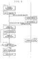
- Fig. 5 is an operation sequence chart for explaining the operation of the navigation system according to this invention in the relationship between the navigation terminal device 1 and the Web server 3.
- Fig. 6 shows an example of screen display.
- a user accesses the map information site by operating the navigation terminal device 1 to download the map information application (step S501).
- the user designates a prescribed facility, such as a station, department store, convenience store, public facility, etc., which is used as a reference point, or otherwise requests the Web server 3 to distribute the map information in a prescribed region by specifying the address, place name or postal number, etc. by character inputting (step S503).
- the Web server 3 receives the inputted character to retrieve the facility and map data base, and distributes the map information in a reduced scale containing the facility centered thereon to the navigation terminal device 1 (steps S504, S505).
- the navigation terminal device 1 displays the map information containing the outskirt of the centered facility used as the reference point.
- Fig. 6A shows an example of the screen display. Now, the station used as the reference point is centered on the screen (step S506).
- the user will move toward his destination while carrying the navigation terminal device 1. However, before he moves , he operates the navigation terminal device 1 to search the destination.
- the searching of the destination is performed by scrolling the screen using the screen scrolling unit 772 (step S507).
- Fig. 6B shows the screen display in this case.
- the route line represented by the straight line connecting the reference point to the destination is left on the screen of the navigation terminal device 1.
- This is carried out by the route line drawing unit 774.
- Fig. 6C shows the screen display in this case.
- the route line drawing unit 774 draws the route connecting a reference point of the location information retrieved by the Web server 3 to the destination so as to be superimposed on the screen with the map information displayed thereon.
- the route line is drawn in such a manner that the orientation from the reference point to the destination is computed by an operation routine incorporated in the route line drawing unit 774, and the computed result is created as a vector having a length and direction.
- the vector is displayed as a straight line on the screen so that the user can follow the route from the reference point to the destination.
- the navigation terminal device has a function of holding the reference point and can exchange the display between the reference point and destination by detecting the fact that a specific button has been operated (steps S510, 511).
- Fig. 6D shows an example of the display screen in this case.
- the user can follow the route from the displayed reference point to the destination and its reverse according to the route line information drawn on the screen of the navigation terminal device 1 (step S508).
- the route line is searched by the route searching unit 776.
- the navigation terminal device 1 requests the Web server 3 to distribute the map information of a prescribed region as the occasion demands and receives the distributed map information (both indicated by dotted lines). This is carried out by the map information display unit 771. Where the destination is not included in the map of the outskirt previously received, the navigation terminal device 1 requests the Web server 3 to distribute the map information of the neighboring outskirt again.
- the destination is searched on the basis of the distributed updated map information by screen scrolling.
- the route line drawing unit 774 draws the route from the reference point to the destination on the screen again by computing the orientation from the reference point to the destination. Even when the map information is updated, the route searching unit 775 can follow the route line from the reference point to the destination which has been drawn on the screen by the route line drawing unit 774.
- the navigation terminal device 1 receives, from the Web server 3, the information of the reference point and destination within a prescribed distance from the displayed center point.
- the direction from the center point to the reference point or destination and the distance therebetween are computed, and they are created and drawn as segment information. It is now assumed that the length of the segment representative of the orientation is set according to the distance.
- the map information was distributed from the Web server 3. However, it may be prepared on the side of the navigation terminal device 1. Although the navigation terminal device 1 accesses the Web server 3 to acquire the location information when the destination is set, it may inherently have the location information.
- the navigation terminal device 1 should not be limited to the portable telephone adopted in the embodiment.
- the PDA, home personal computer, in-vehicle navigation device may be used as the navigation terminal device 1.
- the navigation system according to this invention may be applied to not only the communication network via the internet, but a closed system using the recording medium such as CD-ROM, DVD, etc.
- the procedure shown as a sequence chart in Fig. 5 is previously programmed or recorded in the navigation terminal device 1 and the Web server 3, and the read program is executed by CPU.
- the program is recorded in the recording medium such as a semiconductor memory, optical disk, hard disk, floppy disk, etc. Further, the program is not fixed on these recording media, but may be downloaded via a communication line.
Abstract
Description
- This invention relates to a navigation terminal device in which the map information containing location information retrieved by a server is received through the Web and displayed on a screen, and a method of navigation.
- At present, various kinds of items of information are provided on an internet via the WWW (World-Wide-Web) (hereinafter referred as Web) from the world. A user can retrieve desired information by operating a terminal device connected to the Web.
- One of the various kinds of information services is a map information retrieval service. Through this service, the user can acquire desired map information displayed on a terminal by access to the Web server containing a map data base and connected to the internet.
- Specifically, when the user inputs an address, a place name, a station name or various kinds of facility and store names, the map of the inputted item and its vicinity are displayed on the terminal device as image information. Therefore, with reference the map information thus displayed, the user can easily recognize where the designated station, facility, etc. is located.
- Meanwhile, as the terminal device for the map information retrieval service using the above Web, not only a personal computer equipped with a Web connecting configuration such as a browser, but also an in-vehicle navigation system, a PDA (Personal Digital Assistants), portable telephone, etc. are used.
- However, in the device having a relatively small capacity of screen such as a portable telephone, it is difficult to understand the information on the outskirts of the designated place map-displayed. This requires very troublesome excessive repetition of scrolling. The excessive repetition of scrolling affects not only the operability but waste the communication fee. Sometimes, an objection is raised from a user. This is burden also for the side of the terminal.
- Unlike the in-vehicle navigation system, the portable telephone does not have the function of displaying a present location or setting a route. Therefore, although the present location or destination can be individually retrieved relatively easily, it is not easy to follow the route from the present location to the destination and its reverse. Namely, the portable telephone cannot set the user's own position. Therefore, the facility such as a station searched as a guide is set as a starting point. The destination is retrieved from the starting point by repetitive scrolling. In this case, however, the guide disappears from the screen. Therefore, even if the destination is found, it is difficult to follow the route from the guide to the destination. Therefore, the portable telephone is very poor in the operability. This is remarkable in an unknown place.
- Under such a circumstance, this invention has been accomplished.
- An object of this invention is to provide a navigation terminal device which can improve the operability by retrieving a destination from the map information displayed on a screen and displaying the route from a reference point of the location information retrieved by a server to the retrieved destination by superposition.
- In accordance with a first aspect of this invention, there is provided a navigation terminal device by comprising:
- map information displaying means for displaying the map information containing location information retrieved by a server and received via the Web;
- destination displaying means for displaying a destination searched by screen scrolling from the map information displayed on the screen;
- holding means for holding the retrieved location
information or searched destination or both of them:
- route drawing means for drawing a route from a reference point of the retrieved location information or searched destination to the searched destination or retrieved location information so as to be superimposed on the screen with the map information displayed thereon; and
- a route searching means for exchanging the display between the reference point and the destination if the reference point disappears from the screen when the destination is displayed, thereby permitting to follow the route from the displayed reference point to the destination or from the destination to the reference point.
-
- In accordance with the configuration described above, a destination is searched from the map information displayed on a screen by screen scrolling, and the route from a reference point based on the location information retrieved by the Web server to the destination is superimposed on the map information on the screen. Where the reference point disappears from the screen when the destination is displayed, the display is exchanged from the destination from the reference point so that a user can follow the route from the displayed reference point to the destination according to the drawn route information.
- The route line is drawn in such a manner that the orientation from the reference point to the destination is computed , and the computed result is created as a vector having a length and direction.
- In this way, the regional information to the destination can be easily recognized by following the route. The terminal device having a small capacity of screen can do without redundant scrolling so that its operability is improved and the burden for the user is relaxed. The display is exchanged between the reference point and the destination by operating a specific button so that the operability of the terminal device can be further improved.
- In accordance with the second aspect of this invention, there is provided a navigating method for a navigation system including a server for distributing map information and a navigation terminal device for displaying the map information containing location information retrieved by a server on a screen via the Web, comprising the steps of:
- displaying a destination searched from the map information displayed on the screen by screen scrolling;
- holding the retrieved location information or destination information or both or them;
- drawing a route from a reference point based on the retrieved location information or the searched destination to the searched destination or the retrieved location information so as to be superimposed on the screen with the map information displayed thereon; and
- exchanging the display between the reference point and the destination if the reference point disappears from the screen when the destination is displayed, thereby following the route from the displayed reference point to the destination or the route from the destination to the reference point.
-
- In accordance with the third aspect of this invention, there is provided a navigating terminal program for a navigation system including a server for distributing map information and a navigation terminal device for displaying the map information containing location information retrieved by a server on a screen via the Web, comprising the steps of:
- displaying a destination searched from the map information displayed on the screen by screen scrolling;
- holding the retrieved location information or destination information or both or them;
- drawing a route from a reference point based on the retrieved location information or the searched destination to the searched destination or the retrieved location information so as to be superimposed on the screen with the map information displayed thereon; and
- exchanging the display between the reference point and the destination if the reference point disappears from the screen when the destination is displayed, thereby following the route from the displayed reference point to the destination or the route from the destination to the reference point.
-
- In accordance with the fourth aspect of this invention, there is provided a recording medium which is readable by a computer and stores a navigating terminal program for a navigation system including a server for distributing map information and a navigation terminal device for displaying the map information containing location information retrieved by a server on a screen via the Web, the program causing the computer to execute the steps of:
- displaying a destination searched from the map information displayed on the screen by screen scrolling;
- holding the retrieved location information or destination information or both or them;
- drawing a route from a reference point based on the retrieved location information or the searched destination to the searched destination or the retrieved location information so as to be superimposed on the screen with the map information displayed thereon; and
- exchanging the display between the reference point and the destination if the reference point disappears from the screen when the destination is displayed, thereby following the route from the displayed reference point to the destination or the route from the destination to the reference point.
-
- The above and other objects and features of the invention will be more apparent from the following description taken in conjunction with the accompanying drawings.
-
- Fig. 1 is a view showing an example of a connecting format to which this invention is applied;
- Fig. 2 is a block diagram showing an internal
configuration of a
navigation terminal device 1 in Fig. 1; - Fig. 3 is a block diagram showing the internal configuration expanded in function of a communication application unit 37 shown in Fig. 2;
- Fig. 4 is a block diagram showing the internal configuration expanded in function of a map information application shown in Fig. 3;
- Fig. 5 is an operation sequence for explaining the operation of an embodiment of this invention; and
- Figs. 6A to 6D are views each showing a screen configuration of a navigation terminal device for explaining the embodiment of this invention.
-
- Now referring to the drawings, a detailed explanation will be given of a preferred embodiment of this invention.
- Fig. 1 is a view showing the connecting format of a navigation system to which this invention is applied. In Fig. 1,
reference numeral 1 denotes individual navigation terminal devices each having a browser function as a client; 2 an internet; and 3 a Web server. - Now, a portable telephone having a Web connecting configuration is illustrated as the
navigation terminal device 1. The portable telephone having a relatively small capacity of screen is connected to theinternet 2 though a public switched network or an access service. Theinternet 2 is connected to aWeb server 3 which serves as a map information providing site, a map information data base site and a route setting site. - The map information providing site is a site for carrying out the service of providing the map information by the Web. The map information providing site unifies the information supply to the map data base site and the route setting site described later.
- The map information providing site includes, as a
Web server 3, a data base (DB) in which the land marks such as addresses and facilities and their location information are stored. TheWeb server 3 accesses the data base on the basis of the input information from thenavigation terminal device 1 so that the address or facility is specified from the input location information and the corresponding location information is acquired from the specified land mark. - The map data base site is a site for carrying out the retrieval/display service of the map information on the internet so that the map data read out is supplied to the
navigation terminal device 1. The map data base site includes a map server for supplying map data read out to thenavigation terminal device 1 and a map information data base in which location information indicative of the coordinates by latitudes and longitudes, display information of the map such as a reduced scale, map size, etc. and the image data of the map corresponding to these items of information are stored. - Fig. 2 is a block diagram showing the internal configuration of the
navigation terminal device 1 in Fig. 1. As described above, as thenavigation terminal device 1, the portable telephone provided with the Web connecting configuration is illustrated. - The
navigation terminal device 1 includes a radio control unit 11, a modulating unit 12, ademodulating unit 13, achannel codec 14, an audio input unit 15, an audio output unit 16, acommunication application unit 17, aninput unit 18 and adisplay unit 19. The radio control unit 11,channel codec 14,communication application unit 17,input unit 18 anddisplay unit 19 are commonly connected to an internal bus 20. - The radio control unit 11 serves to transmit modulated data supplied by the modulating unit 12 from an antenna together with a radio carrier wave and receive the signal at a prescribed frequency from the high frequency signals induced at the antenna. The modulating unit 12 serves to modulate the transmission data outputted from the
channel codec 14 in a prescribed system (e.g. π/4 shift DPQSK) and supply the modulated data to the radio control unit 11. Thedemodulating unit 13 serves to demodulate the signal received by the radio control unit 11 and supply the signal thus demodulated to thechannel codec 14. - The
channel codec 14 divisionally supplies the data received from thedemodulating unit 13 to the audio output unit 16 or thecommunication application 17. Thechannel codec 14 also divisionally supplies the audio received from the audio input unit 15 to the modulating unit 12 or thecommunication application unit 17. Thechannel codec 14 also divisionally supplies the data received from thecommunication application unit 17 to the modulating unit 12 or the audio output unit 16. - The
communication application unit 17 includes a CPU, ROM and RAM and serves as a control center for thenavigation terminal device 1 which performs not only the connecting control for communication but also control for the creation of the transmission data, display/reserve of the received data and processing of the received/transmitted data. The details thereof will be explained later. - The
input unit 18 recognizes the connected key or button to input a dialing number and display image operating data. Thedisplay unit 19 displays, on a connected screen display monitor, the data produced from thecommunication application unit 17 and stored in the display memory not shown. - Fig. 3 is a developed block diagram of the internal configuration of the
communication application unit 17 as shown in Fig. 2. Concretely, thecommunication application unit 17 is constructed of a peripheral LSI such as aninput unit 18,display unit 19, etc. inclusive of the CPU, ROM/RAM. The function of each block described later is realized in such a manner that CPU reads the program stored in the ROM and executes it using the RAM. - The
communication application unit 17 includes an input control unit 171, an audio control unit 172, a display control unit 173, anapplication management unit 174, abrowser application 175, amail application 176, amap information application 177, anaudio telephone application 178, a receiveddata management unit 179 and a communication control unit 180. - The input control unit 171 informs the
application management unit 174 of the input key information and others received from theinput unit 18. The display control unit 173 performs the control of supplying the display information received from theapplication management unit 174 to thedisplay unit 19. The audio control unit 173 performs the control of informing theapplication management unit 174 of the audio received from the audio input unit 15 or supplying the audio received from theapplication management unit 174 to thechannel codec 14. - The
application management unit 174 performs the management of selecting one of a plurality of applications prepackaged in thenavigation terminal device 1 according to this invention, or exchanging the information between each application and the input control unit 171, display control unit 172, audio control unit 173. It is now assumed that four applications of thebrowser application 175,mail application 176,map information application 177 andaudio telephone application 178 have been prepackaged. However, it is needless to say that any other application can be also prepackaged. - The applications to be prepackaged are classified into applications designed for the audio service and for the character service. The former does not carry out the transmission/reception of character data and image data, but supports the audio. The
audio telephone application 178 is an example thereof. The latter does not carry out the transmission/reception of the character data and image data such as a map and supports the screen display of each item of information to be transmitted or received. Thebrowser application 175,mail application 176 and themap information application 177 are examples thereof. - The internal configuration expanded in function of the
map information application 177 is shown in Fig. 4. Themap information application 177 includes a map information display unit 771, a scrollingcontrol unit 772, adestination display unit 773, a routeline drawing unit 774 and a route searching unit 775. - The map information display unit 771 has a function of displaying, on a screen of the
display unit 19, the map information containing the location information retrieved by theWeb server 3 which is received via theinternet 2. Thedestination display unit 773 has a function of displaying the destination searched from the map information displayed on the screen of thedisplay unit 19 by the scroll controlling by the scrollingcontrol unit 772. - The route
line drawing unit 774 has a function of drawing the route connecting a reference point based on the location information retrieved by theWeb server 3 to the destination so as to be superimposed on the screen with the map information displayed thereon. The route is represented by the straight line extended from the center of the map information displayed on the screen to the reference point. The route searching unit 775 has a function of re-drawing the route from the reference point to the destination on the basis the updated screen when distribution of the map information is requested. - The route searching unit 775 has a function of exchanging the display between the reference point and the destination when the destination is displayed by the
destination display unit 773 but the reference point disappears from the screen, thereby following the route from the reference point to the destination according to the drawn route information. - Again referring to Fig. 3, the communication control unit 180 performs the dialing/calling connection and data communication control according to the command from each of the
applications data managing unit 179 is located between the communication control unit 180 and each of thebrowser application 175,mail application 176 andmap information application 177 to manage the received data to be transferred from the former to the latter. - Fig. 5 is an operation sequence chart for explaining the operation of the navigation system according to this invention in the relationship between the
navigation terminal device 1 and theWeb server 3. Fig. 6 shows an example of screen display. - Now referring to Figs. 5 and 6, an explanation will be given of the operation of the navigation system according to the embodiment of this invention.
- First, a user accesses the map information site by operating the
navigation terminal device 1 to download the map information application (step S501). The user designates a prescribed facility, such as a station, department store, convenience store, public facility, etc.,
which is used as a reference point, or otherwise requests theWeb server 3 to distribute the map information in a prescribed region by specifying the address, place name or postal number, etc. by character inputting (step S503). - The
Web server 3 receives the inputted character to retrieve the facility and map data base, and distributes the map information in a reduced scale containing the facility centered thereon to the navigation terminal device 1 (steps S504, S505). - The
navigation terminal device 1 displays the map information containing the outskirt of the centered facility used as the reference point. Fig. 6A shows an example of the screen display. Now, the station used as the reference point is centered on the screen (step S506). - Next, the user will move toward his destination while carrying the
navigation terminal device 1. However, before he moves , he operates thenavigation terminal device 1 to search the destination. The searching of the destination is performed by scrolling the screen using the screen scrolling unit 772 (step S507). - Now it is assumed that when the destination is displayed by the destination display unit, the station which is the previous reference point has disappeared from the screen. Fig. 6B shows the screen display in this case.
- However, the route line represented by the straight line connecting the reference point to the destination is left on the screen of the
navigation terminal device 1. This is carried out by the routeline drawing unit 774. Fig. 6C shows the screen display in this case. The routeline drawing unit 774 draws the route connecting a reference point of the location information retrieved by theWeb server 3 to the destination so as to be superimposed on the screen with the map information displayed thereon. - The route line is drawn in such a manner that the orientation from the reference point to the destination is computed by an operation routine incorporated in the route
line drawing unit 774, and the computed result is created as a vector having a length and direction. The vector is displayed as a straight line on the screen so that the user can follow the route from the reference point to the destination. - The navigation terminal device according to this invention has a function of holding the reference point and can exchange the display between the reference point and destination by detecting the fact that a specific button has been operated (steps S510, 511). Fig. 6D shows an example of the display screen in this case.
- The user can follow the route from the displayed reference point to the destination and its reverse according to the route line information drawn on the screen of the navigation terminal device 1 (step S508). The route line is searched by the route searching unit 776.
- During the process from step S506 (display of the reference point) to step 507 (setting of the destination), the
navigation terminal device 1 requests theWeb server 3 to distribute the map information of a prescribed region as the occasion demands and receives the distributed map information (both indicated by dotted lines). This is carried out by the map information display unit 771. Where the destination is not included in the map of the outskirt previously received, thenavigation terminal device 1 requests theWeb server 3 to distribute the map information of the neighboring outskirt again. - The destination is searched on the basis of the distributed updated map information by screen scrolling. The route
line drawing unit 774 draws the route from the reference point to the destination on the screen again by computing the orientation from the reference point to the destination. Even when the map information is updated, the route searching unit 775 can follow the route line from the reference point to the destination which has been drawn on the screen by the routeline drawing unit 774. - The
navigation terminal device 1 receives, from theWeb server 3, the information of the reference point and destination within a prescribed distance from the displayed center point. The direction from the center point to the reference point or destination and the distance therebetween are computed, and they are created and drawn as segment information. It is now assumed that the length of the segment representative of the orientation is set according to the distance. - In the above embodiment of this invention, the map information was distributed from the
Web server 3. However, it may be prepared on the side of thenavigation terminal device 1. Although thenavigation terminal device 1 accesses theWeb server 3 to acquire the location information when the destination is set, it may inherently have the location information. - Further, the
navigation terminal device 1 should not be limited to the portable telephone adopted in the embodiment. The PDA, home personal computer, in-vehicle navigation device may be used as thenavigation terminal device 1. The navigation system according to this invention may be applied to not only the communication network via the internet, but a closed system using the recording medium such as CD-ROM, DVD, etc. - Incidentally, the procedure shown as a sequence chart in Fig. 5 is previously programmed or recorded in the
navigation terminal device 1 and theWeb server 3, and the read program is executed by CPU. However, the program is recorded in the recording medium such as a semiconductor memory, optical disk, hard disk, floppy disk, etc. Further, the program is not fixed on these recording media, but may be downloaded via a communication line. - Incidentally, the contents of Japanese Patent Appln. No. 2001-13362 filed on April 27, 2001 are hereby incorporated by reference.
Claims (4)
- A navigation terminal device comprising:map information displaying means for displaying the map information containing location information retrieved by a server and received via the Web;destination displaying means for displaying a destination searched by screen scrolling from the map information displayed on the screen;holding means for holding the retrieved location information or searched destination or both of them:route drawing means for drawing a route from a reference point of the retrieved location information or searched destination to the searched destination or retrieved location information so as to be superimposed on the screen with the map information displayed thereon; anda route searching means for exchanging the display between the reference point and the destination if the reference point disappears from the screen when the destination is displayed, thereby permitting to follow the route from the displayed reference point to the destination or from the destination to the reference point.
- A navigating method for a navigation system including a server for distributing map information and a navigation terminal device for displaying the map information containing location information retrieved by a server on a screen via the Web, comprising the steps of:displaying a destination searched by screen scrolling from the map information displayed on the screen;holding the retrieved location information or destination information or both or them;drawing a route from a reference point based on the retrieved location information or the searched destination to the searched destination or the retrieved location information so as to be superimposed on the screen with the map information displayed thereon; andexchanging the display between the reference point and the destination if the reference point disappears from the screen when the destination is displayed, thereby following the route from the displayed reference point to the destination or the route from the destination to the reference point.
- A navigating terminal program for a navigation system including a server for distributing map information and a navigation terminal device for displaying the map information containing location information retrieved by a server on a screen via the Web, comprising the steps of:displaying a destination searched by screen scrolling from the map information displayed on the screen;holding the retrieved location information or destination information or both or them;drawing a route from a reference point based on the retrieved location information or the searched destination to the searched destination or the retrieved location information so as to be superimposed on the screen with the map information displayed thereon; andexchanging the display between the reference point and the destination if the reference point disappears from the screen when the destination is displayed, thereby following the route from the displayed reference point to the destination or the route from the destination to the reference point.
- A recording medium which is readable by a computer and stores a navigating terminal program for a navigation system including a server for distributing map information and a navigation terminal device for displaying the map information containing location information retrieved by a server on a screen via the Web, said program causing the computer to execute the steps of:displaying a destination searched by screen scrolling from the map information displayed on the screen;holding the retrieved location information or destination information or both or them;drawing a route from a reference point based on the retrieved location information or the searched destination to the searched destination or the retrieved location information so as to be superimposed on the screen with the map information displayed thereon; andexchanging the display between the reference point and the destination if the reference point disappears from the screen when the destination is displayed, thereby following the route from the displayed reference point to the destination or the route from the destination to the reference point.
Applications Claiming Priority (2)
| Application Number | Priority Date | Filing Date | Title |
|---|---|---|---|
| JP2001133362 | 2001-04-27 | ||
| JP2001133362A JP4391037B2 (en) | 2001-04-27 | 2001-04-27 | Navigation device, navigation method, and navigation program |
Publications (2)
| Publication Number | Publication Date |
|---|---|
| EP1253403A2 true EP1253403A2 (en) | 2002-10-30 |
| EP1253403A3 EP1253403A3 (en) | 2007-07-04 |
Family
ID=18981233
Family Applications (1)
| Application Number | Title | Priority Date | Filing Date |
|---|---|---|---|
| EP02009607A Withdrawn EP1253403A3 (en) | 2001-04-27 | 2002-04-26 | Navigation terminal device and navigation method |
Country Status (3)
| Country | Link |
|---|---|
| US (2) | US20020161515A1 (en) |
| EP (1) | EP1253403A3 (en) |
| JP (1) | JP4391037B2 (en) |
Families Citing this family (2)
| Publication number | Priority date | Publication date | Assignee | Title |
|---|---|---|---|---|
| JP5027634B2 (en) * | 2007-12-07 | 2012-09-19 | シャープ株式会社 | Navigation device and navigation method |
| US9311426B2 (en) * | 2011-08-04 | 2016-04-12 | Blackberry Limited | Orientation-dependent processing of input files by an electronic device |
Citations (4)
| Publication number | Priority date | Publication date | Assignee | Title |
|---|---|---|---|---|
| US4677561A (en) * | 1984-04-28 | 1987-06-30 | Mitsubishi Denki Kabushiki Kaisha | Automotive navigation system |
| JPH0972753A (en) * | 1995-09-06 | 1997-03-18 | Niles Parts Co Ltd | Method for retrieving and registering course information in navigation system |
| JPH11296074A (en) * | 1998-04-14 | 1999-10-29 | Inkurimento P Kk | System and method for providing route information |
| US6148253A (en) * | 1998-05-21 | 2000-11-14 | Alpine Electronics, Inc. | On-vehicle control system |
Family Cites Families (36)
| Publication number | Priority date | Publication date | Assignee | Title |
|---|---|---|---|---|
| US5196838A (en) * | 1990-12-28 | 1993-03-23 | Apple Computer, Inc. | Intelligent scrolling |
| DE69333916T2 (en) * | 1992-07-23 | 2006-07-06 | Aisin AW Co., Ltd., Anjo | Navigation device for vehicles for determining a new route when a vehicle deviates from its route |
| EP0583773B1 (en) * | 1992-08-19 | 2001-07-25 | Aisin Aw Co., Ltd. | Navigation system for vehicles |
| EP0660289B1 (en) * | 1993-12-27 | 2001-10-04 | Aisin Aw Co., Ltd. | Map display system |
| JP3277889B2 (en) | 1993-12-29 | 2002-04-22 | アイシン・エィ・ダブリュ株式会社 | Route information providing device |
| JPH08247778A (en) * | 1995-03-07 | 1996-09-27 | Aqueous Res:Kk | Input unit for navigation |
| US5745866A (en) * | 1996-01-09 | 1998-04-28 | Trimble Navigation Limited | Cardinal-up graphic map display system |
| SG75807A1 (en) * | 1996-01-11 | 2000-10-24 | Sony Corp | Signal transmitting method and apparatus |
| US6147670A (en) * | 1997-03-13 | 2000-11-14 | Phone.Com, Inc. | Method of displaying elements having a width greater than a screen display width |
| JP3372021B2 (en) * | 1997-05-01 | 2003-01-27 | 松下電器産業株式会社 | Map information providing system |
| KR100313055B1 (en) * | 1997-05-15 | 2001-12-28 | 다니구찌 이찌로오, 기타오카 다카시 | Navigation device |
| JPH1164010A (en) * | 1997-08-11 | 1999-03-05 | Alpine Electron Inc | Method for displaying map of navigation system |
| US6256582B1 (en) * | 1997-11-18 | 2001-07-03 | Mannesmann Vdo Ag | Method and device for navigation support of a vehicle driver |
| US6249740B1 (en) * | 1998-01-21 | 2001-06-19 | Kabushikikaisha Equos Research | Communications navigation system, and navigation base apparatus and vehicle navigation apparatus both used in the navigation system |
| JPH11311533A (en) * | 1998-04-28 | 1999-11-09 | Xanavi Informatics Corp | Routing device |
| US6175801B1 (en) * | 1998-06-19 | 2001-01-16 | Magelan Dts, Inc. | Navigation system map panning directional indicator |
| JP3791728B2 (en) * | 1998-06-03 | 2006-06-28 | コナミ株式会社 | GAME SCREEN DISPLAY CONTROL METHOD, GAME SYSTEM, AND COMPUTER-READABLE RECORDING MEDIUM |
| DE19837510A1 (en) * | 1998-08-19 | 2000-02-24 | Bayerische Motoren Werke Ag | Device for controlling the reproduction of an image displayed on a vehicle screen |
| JP3459000B2 (en) * | 1998-09-22 | 2003-10-20 | インターナショナル・ビジネス・マシーンズ・コーポレーション | Method of displaying objects displayed in a plurality of client areas and display device used therefor |
| US7320105B1 (en) * | 1998-12-01 | 2008-01-15 | Intel Corporation | Data display using multicolumn scrolling |
| EP1035531B1 (en) * | 1999-03-05 | 2006-04-26 | Hitachi, Ltd. | Information providing system for mobile units |
| TW444502B (en) * | 1999-04-06 | 2001-07-01 | Winbond Electronics Corp | Method for improving resolution of indicator's pointer movement |
| JP3543690B2 (en) * | 1999-08-11 | 2004-07-14 | 日本電気株式会社 | Map display terminal, map display method used therefor, and recording medium recording control program therefor |
| EP1122515B1 (en) * | 1999-08-12 | 2006-04-12 | Mitsubishi Denki Kabushiki Kaisha | Navigation device |
| US6643416B1 (en) * | 1999-11-30 | 2003-11-04 | Eastman Kodak Company | Method for determining necessary resolution for zoom and crop images |
| US6856326B1 (en) * | 2000-01-28 | 2005-02-15 | International Business Machines Corporation | Smooth scrolling system and method |
| JP3475142B2 (en) * | 2000-03-01 | 2003-12-08 | 三菱電機株式会社 | Map data transmission device, map data transmission method, and computer-readable recording medium recording a program for causing a computer to execute the map data transmission method |
| DE10010608A1 (en) * | 2000-03-03 | 2001-09-06 | Mannesmann Vdo Ag | Navigation with small data quantities involves comparing distance covered between way points with stored distance to output driving notices when difference below minimum value |
| JP2001280992A (en) * | 2000-03-29 | 2001-10-10 | Hitachi Ltd | Geographical information output system |
| US7142205B2 (en) * | 2000-03-29 | 2006-11-28 | Autodesk, Inc. | Single gesture map navigation graphical user interface for a personal digital assistant |
| JP2001289661A (en) * | 2000-04-07 | 2001-10-19 | Alpine Electronics Inc | Navigator |
| US6718258B1 (en) * | 2000-06-08 | 2004-04-06 | Navigation Technologies Corp | Method and system for obtaining user feedback regarding geographic data |
| US6642936B1 (en) * | 2000-08-08 | 2003-11-04 | Tektronix, Inc. | Touch zoom in/out for a graphics display |
| US6983331B1 (en) * | 2000-10-17 | 2006-01-03 | Microsoft Corporation | Selective display of content |
| US6650326B1 (en) * | 2001-01-22 | 2003-11-18 | Navigation Technologies Corp. | Method of handling context during scaling with a map display |
| US6972776B2 (en) * | 2001-03-20 | 2005-12-06 | Agilent Technologies, Inc. | Scrolling method using screen pointing device |
-
2001
- 2001-04-27 JP JP2001133362A patent/JP4391037B2/en not_active Expired - Lifetime
-
2002
- 2002-04-23 US US10/127,502 patent/US20020161515A1/en not_active Abandoned
- 2002-04-26 EP EP02009607A patent/EP1253403A3/en not_active Withdrawn
-
2007
- 2007-12-17 US US11/957,588 patent/US8131457B2/en not_active Expired - Fee Related
Patent Citations (4)
| Publication number | Priority date | Publication date | Assignee | Title |
|---|---|---|---|---|
| US4677561A (en) * | 1984-04-28 | 1987-06-30 | Mitsubishi Denki Kabushiki Kaisha | Automotive navigation system |
| JPH0972753A (en) * | 1995-09-06 | 1997-03-18 | Niles Parts Co Ltd | Method for retrieving and registering course information in navigation system |
| JPH11296074A (en) * | 1998-04-14 | 1999-10-29 | Inkurimento P Kk | System and method for providing route information |
| US6148253A (en) * | 1998-05-21 | 2000-11-14 | Alpine Electronics, Inc. | On-vehicle control system |
Also Published As
| Publication number | Publication date |
|---|---|
| JP2002328037A (en) | 2002-11-15 |
| US20080109155A1 (en) | 2008-05-08 |
| JP4391037B2 (en) | 2009-12-24 |
| EP1253403A3 (en) | 2007-07-04 |
| US8131457B2 (en) | 2012-03-06 |
| US20020161515A1 (en) | 2002-10-31 |
Similar Documents
| Publication | Publication Date | Title |
|---|---|---|
| US6871142B2 (en) | Navigation terminal device and navigation method | |
| JP4667696B2 (en) | Calendar display device for mobile terminal and related method | |
| US7783419B2 (en) | Content display device and content display method | |
| EP0785535A1 (en) | Integrated guidance system for vehicles | |
| US20030100316A1 (en) | Map information display system | |
| US20020035609A1 (en) | Location bookmark system and method for creating and using location information | |
| US20070233384A1 (en) | Method and system for off-board navigation with a portable device | |
| WO2005104730A2 (en) | Item of interest marking and posting system and method | |
| US20070005558A1 (en) | Asset management system | |
| JPH08285613A (en) | Information centralized control type navigation system | |
| JP2000076280A (en) | Information retrieval system utilizing geographical information | |
| TW589856B (en) | Information transmission system, information sending/receiving system and information terminal | |
| US7098923B2 (en) | Navigation terminal device and navigation method | |
| US8131457B2 (en) | Navigation terminal device and navigation method | |
| JP2010026546A (en) | Content provision system | |
| JP2004279299A (en) | System for using electronic coupon, and computer program and method for realizing the same | |
| SE513544C2 (en) | Facility and procedure for providing a service | |
| JP2001067365A (en) | Information providing device, information terminal for transmitting/receiving to and from the device and information management device managing these devices | |
| JPH09330326A (en) | Portable information processing system | |
| JP2003153323A (en) | Method of transmitting facility information by radio, and control center using this method | |
| JP2001331492A (en) | Map information providing method, device therefor and recording medium having the method programmed and recorded thereon | |
| JP2007234057A (en) | Server | |
| JP2007048106A (en) | Street information providing system | |
| JP2003141406A (en) | Electronic coupon issuing system | |
| JPH11203304A (en) | Address data information input system |
Legal Events
| Date | Code | Title | Description |
|---|---|---|---|
| PUAI | Public reference made under article 153(3) epc to a published international application that has entered the european phase |
Free format text: ORIGINAL CODE: 0009012 |
|
| AK | Designated contracting states |
Kind code of ref document: A2 Designated state(s): AT BE CH CY DE DK ES FI FR GB GR IE IT LI LU MC NL PT SE TR |
|
| AX | Request for extension of the european patent |
Free format text: AL;LT;LV;MK;RO;SI |
|
| PUAL | Search report despatched |
Free format text: ORIGINAL CODE: 0009013 |
|
| AK | Designated contracting states |
Kind code of ref document: A3 Designated state(s): AT BE CH CY DE DK ES FI FR GB GR IE IT LI LU MC NL PT SE TR |
|
| AX | Request for extension of the european patent |
Extension state: AL LT LV MK RO SI |
|
| AKX | Designation fees paid | ||
| STAA | Information on the status of an ep patent application or granted ep patent |
Free format text: STATUS: THE APPLICATION IS DEEMED TO BE WITHDRAWN |
|
| 18D | Application deemed to be withdrawn |
Effective date: 20080105 |
|
| REG | Reference to a national code |
Ref country code: DE Ref legal event code: 8566 |