EP1103787A1 - Communication route guidance system - Google Patents
Communication route guidance system Download PDFInfo
- Publication number
- EP1103787A1 EP1103787A1 EP00124353A EP00124353A EP1103787A1 EP 1103787 A1 EP1103787 A1 EP 1103787A1 EP 00124353 A EP00124353 A EP 00124353A EP 00124353 A EP00124353 A EP 00124353A EP 1103787 A1 EP1103787 A1 EP 1103787A1
- Authority
- EP
- European Patent Office
- Prior art keywords
- data
- mobile unit
- information center
- route
- destination
- Prior art date
- Legal status (The legal status is an assumption and is not a legal conclusion. Google has not performed a legal analysis and makes no representation as to the accuracy of the status listed.)
- Granted
Links
Images


Classifications
-
- G—PHYSICS
- G01—MEASURING; TESTING
- G01C—MEASURING DISTANCES, LEVELS OR BEARINGS; SURVEYING; NAVIGATION; GYROSCOPIC INSTRUMENTS; PHOTOGRAMMETRY OR VIDEOGRAMMETRY
- G01C21/00—Navigation; Navigational instruments not provided for in groups G01C1/00 - G01C19/00
- G01C21/26—Navigation; Navigational instruments not provided for in groups G01C1/00 - G01C19/00 specially adapted for navigation in a road network
- G01C21/34—Route searching; Route guidance
Definitions
- the present invention relates to a communication route guidance system for guiding a mobile unit to a destination and, more particularly to a communication route guidance system wherein communication is made between an information center and at least one mobile unit, both storing road data.
- the mobile unit has a communication terminal mounted thereon.
- Japanese patent laid-open publication No.10-19588 discloses an example of the prior art communication route guidance system wherein map image data, recommended route data (or optimum route data) and other data necessary in route guidance are transmitted from an information center to a mobile unit.
- the information center operates, in response to a request from the mobile unit, to read out necessary data from database and prepare the map image data. It also makes route search operation to prepare the optimum route data. The information center then transmits the map image data and the optimum route data thus prepared to the mobile unit. The mobile unit guides the user of the mobile unit to the destination in accordance with such data transmitted from the information center.
- the mobile unit is not capable of receiving data from the information center when the mobile unit is in an area in which the mobile unit is not or hardly communicable with the information center.
- Such an area is hereinbelow referred to as "incommunicable area”.
- Such trouble may also occur when a system in the information center becomes broken down.
- a communication route guidance system wherein an information center transmits route information to a mobile unit for guiding said mobile unit from its current position to a destination, in response to a request from said mobile unit,
- said information center further comprises information collection means for obtaining the latest traffic and road information, said first road data stored in said first memory means being updated in response to said latest traffic and road information obtained by said information collection means.
- said first route search means plans a new route guidance data for guiding said mobile unit from the current position of said mobile unit to said destination in response to said request from said mobile unit, said new route guidance data being divided by said data dividing means into a plurality of said segmental data which are transmitted to said mobile unit so that said segmental data are stored in said third memory means.
- said sensor means may comprise measurement means for measuring field intensity of a radio wave in data transmission from said information center; and means for judging that data is incommunicable with said information center when said measured field intensity is below a predetermined threshold level.
- said sensor means may comprise means for judging that data is incommunicable with said information center when said mobile unit receives none of said segmental data from said information center within a predetermined time period after transmitting said request to said information center.
- Said sensor means may also comprise communicable area data memory means for storing data specifying communicable areas in which said mobile unit is communicable with said information center; and means for judging, in accordance with said data stored in said communicable area data memory means, that there is incommunicability between said mobile unit and said information center when said mobile unit is outside of any of said communicable areas.
- a communication route guidance system wherein an information center transmits route information to a mobile unit for guiding said mobile unit from its current position to a destination, in response to a request from said mobile unit,
- said information center further comprises information collection means for obtaining the latest traffic and road information, said road data stored in said first memory means being updated in response to said latest traffic and road information obtained by said information collection means.
- said mobile unit transmits said request to said information center for being guided to said destination, each time when a length of the remaining route guidable by said continuous series of said segmental data which said mobile unit has received in the last segmental data transmission from said information center becomes shorter than a predetermined distance, and said route search means plans said route guidance data each time when said information center receives said request from said mobile unit.
- said mobile unit transmits said request to said information center at a predetermined periodic interval or a predetermined distance interval of movement of said mobile unit, and said route search means plans said route guidance data for guiding said mobile unit from said current position to said destination. each time when said information center receives said request from said mobile unit.
- said route search means plans said route guidance data for guiding said mobile unit from said current position to said destination at a predetermined periodic interval or a predetermined distance interval of movement of said mobile unit.
- a communication-route guidance system wherein an information center transmits route information to a mobile unit for guiding said mobile unit from its current position to a destination, in response to a request from said mobile unit,
- said information center further comprises information collection means for obtaining the latest traffic and road information, said first road data stored in said first memory means being updated in response to said latest traffic and road information obtained by said information collection means.
- said mobile unit transmits said request to said information center for being guided to said destination, each time when a length of the remaining route guidable by said continuous series of said segmental data which said mobile unit has received in the last segmental data transmission from said information center becomes shorter than a predetermined distance, and said first route search means plans said first route guidance data each time when said information center receives said request from said mobile unit.
- said mobile unit transmits said request to said information center at a predetermined periodic interval or a predetermined distance interval of movement of said mobile unit, and said first route search means plans said first route guidance data for guiding said mobile unit from said current position to said destination each time when said information center receives said request from said mobile unit.
- said first route search means plans said first route guidance data for guiding said mobile unit from said current position to said destination at a predetermined periodic interval or a predetermined distance interval of movement of said mobile unit.
- a communication route guidance system wherein an information center transmits route information to a mobile unit for guiding said mobile unit from its current position to a destination. in response to a request from said mobile unit,
- said first route search means plans a new route guidance data for guiding said mobile unit from the current position of said mobile to said destination, whereby said route guidance means guides said mobile unit in accordance with said new route guidance data planned by said first route search means and transmitted from said information center to said mobile unit.
- said second location data stored in said second memory means contains data specifying a representative location within an area including a location to be designated by input of telephone number and/or address through said input means.
- said sensor means comprises measurement means for measuring field intensity of a radio wave in data transmission from said information center; and means for judging that data is incommunicable with said information center when said measured field intensity is below a threshold level.
- said sensor means comprises means for judging that data is incommunicable with said information center when said mobile unit receives none of said first route guidance data from said information center within a predetermined time period after transmitting said request to said information center.
- said sensor means comprises communicable area memory means for storing data specifying communicable areas in which said mobile unit is communicable with said information center; and means for judging, in accordance with said data stored in said communicable area memory means, that there is incommunicability between said mobile unit and said information center when said mobile unit is outside of any of said communicable areas.
- Typical examples for the mobile unit mentioned above are not only a navigation apparatus mounted on a vehicle and a handy navigation apparatus for a pedestrian, but also personal computer, laptop computer, personal digital assistant ( PDA ), cellular phone, and pager , with which proper devices are added.
- PDA personal digital assistant
- a navigation apparatus mounted on a vehicle
- PDA personal digital assistant
- the system comprises an information center 10 and a navigation apparatus 100 mounted on a vehicle.
- Communication unit 12 including a transmitter and a receiver, which allows data transmission to navigation apparatus 100 as well as data receiving therefrom.
- Communication unit 12 may comprises car phone, cellular phone, portable handy phone system (PHS), etc.
- An arithmetic processing unit 14 includes a central processing unit (CPU) 16 that executes various processing and control operation and a memory 18 that stores various programs and data.
- CPU central processing unit
- memory 18 stores a route search program 20 for searching a route from a current vehicle position (that is a vehicle position at the time the navigation operation starts or a starting point) to a destination (where the navigation operation terminates), segmentation program 22 for dividing a planned route into segmental routes and determining a route length to be transmitted to navigation apparatus 100, guidance data search program 24 for searching, extracting and editing guidance data corresponding to the route length determined by the segmentation program 22, communicability judgment program 25 for judging whether or not data transmission is possible, system control program 26 for controlling and managing the overall operation, and other programs to be executed by information center 10.
- Memory 18 has also a working area for use in execution of these programs.
- Database 30 stores road data 32 for searching a route to the destination, guidance data 34 comprising plural data for guiding the user of the navigation apparatus to the destination along a searched route, communicable area data 36 comprises plural data regarding communicable areas, destination specifying data 38 comprising coordinates of various points in combination with their telephone numbers and/or addresses which may be used in determination of destinations, and other data to be used in route search and route guidance operation.
- the road data 32 typically comprises a road network data including crossing data and node data.
- the guidance data 34 includes map data of respective crossings and roads, landmark data and voice guidance data.
- the communicable area data 36 is the data for specifying the area in which the navigation apparatus can communicate with the information center.
- An external information collection unit 40 is connected to database 30 for obtaining the latest information regarding roads, traffic and communication conditions from other information center by means of telephone lines or other communication devices.
- Typical examples of the latest information includes information of traffic jams, traffic accidents, road repairing, traffic restriction, newly-constructed roads, newly-established institutions, change of communicable and/or incommunicable areas, etc.
- the latest information is used to update data stored in database 30.
- Some kinds of the latest information such as information of traffic jams, traffic accidents, road repairing, traffic restriction, newly-constructed roads, newly-established institutions, etc. should be correlated with location and date (and time) of its occurrence.
- the traffic jam information should be obtained with location and date-and-time where and when a traffic jam occurs. This is also applicable to the traffic accident information.
- an arithmetic processing unit 101 which typically comprises a central processing unit (CPU).
- a program storing area 102A of a memory 102 stores a route guidance program 150 for representing a drive route and landmarks therearound on a display 106 and outputting a route guidance message through a voice outputting device or a speaker 107 in accordance with route guidance data transmitted from information center 10, a data request program 152 for requesting new route guidance data for guiding the user of the navigation apparatus along a next drive route by comparison between the current vehicle position and the route guidance data now in operation, a control program 154 for controlling the overall operation, and other programs to be executed by arithmetic processing unit 101.
- a route guidance program 150 for representing a drive route and landmarks therearound on a display 106 and outputting a route guidance message through a voice outputting device or a speaker 107 in accordance with route guidance data transmitted from information center 10
- a data request program 152 for requesting new route guidance data for guiding the user of the navigation apparatus along a next
- Data storing area 102B of memory 102 has a working area for use in execution of those programs. Additionally, route guidance data 160 (which comprises route data and guidance data) transmitted from information center 10, ID data 162 identifying navigation apparatus 100, vehicle position data 164 (which comprises latitude and longitude of vehicle position) detected by a position sensor 104 are also stored in data storing area 102B.
- route guidance data 160 (which comprises route data and guidance data) transmitted from information center 10, ID data 162 identifying navigation apparatus 100, vehicle position data 164 (which comprises latitude and longitude of vehicle position) detected by a position sensor 104 are also stored in data storing area 102B.
- Vehicle position data 164 comprises a series of the vehicle positions obtained by the latest, several-time detection by position sensor 104. For example, a series of the past vehicle positions within a predetermined distance, or a predetermined number of the past vehicle positions may be stored as vehicle position data 164. Once position sensor 104 detects a new vehicle position, vehicle position data 164 is updated such that said new vehicle position is added as the latest data and the oldest one is removed.
- a series of the past vehicle positions represents a track of movement of the vehicle. The track of movement of the vehicle may be used in so-called map-matching operation to specify a road on which the vehicle is running.
- Position sensor 104 has a Global Positioning System (GPS) receiver which receives radio waves from plural earth satellites to determine absolute coordinates of the vehicle current position. Position sensor 104 may also have a speed meter and a compass, both are used to determine a relative position of the vehicle by dead reckoning method. The relative position determined by those sensors may be used in a case when no radio waves is receivable by the GPS receiver or the vehicle is running through a tunnel. The relative vehicle position may also be used to eliminate an error of the absolute vehicle position detected by the GPS receiver.
- GPS Global Positioning System
- An input device 105 may include various switches, a touch panel attached to a front panel of display 106, a remote control unit and a voice input unit. In data inputting operation with the touch panel, a touch by a user's finger on a particular icon shown on display 106 will input corresponding data or command.
- the voice input unit receives and recognized-the user's voice that corresponding data or command may be inputted.
- Display 106 may comprise a liquid crystal display (LCD) or a cathode-ray tube (CRT) with the above-described touch panel.
- a communication unit 108 includes a transmitter and a receiver, which allows data transmission to information center 10 as well as data receiving therefrom. As described before in connection with communication unit 12 in information center 10, communication unit 108 may comprises car phone, cellular phone, PHS, etc.
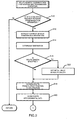
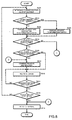
- Figs.2 and 3 show a flowchart of route guidance data preparation and transmission operation executed at the information center.
- control program 154 stored in memory 102 has been executed by arithmetic processing unit 101 in navigation apparatus 100.
- data request program 152 stored in memory 102 is executed in response to the user's input operation through input device 105, data including the current vehicle position detected by position sensor 104, the destination. and the route length along which the navigation apparatus requires route guidance from information center 10 are transmitted to information center 10 through communication unit 108 (as shown by a step S50 in a flowchart of Fig.6 to be described later).
- An ID code distinguishing the own navigation apparatus from other navigation apparatus is also transmitted to information center 10 at the same time.
- Information center 10 receives these data through communication unit 12 (Yes at a step S10) and transfers the same to arithmetic processing unit 14. Communication between information center 10 and navigation apparatus 100 may preferably be made by packet transmission.
- Arithmetic processing unit 14 in information center 10 executes the system control program 26 stored in memory 18.
- the route search program 20 stored in memory 18 is executed by CPU 16 to start route search operation. More particularly, the current vehicle position data and the destination data are picked out from the received data (at a step S12) and a particular destination is determined from the destination data (at a step S14). For example, in a case where the destination is pointed by a telephone number or an address, a particular destination is determined in reference to the destination specifying data 38 in database 30.
- a guidance-demanding route length is specified in the received data (Yes at a step S16)
- this is preserved in memory 18 as route length data 27 and a drive route from the current vehicle position to the destination is searched and planned (at a step S18).
- a predetermined initial value is preserved as the route length data 27 (at a step S22), followed by drive route search operation at S18.
- the drive route search operation is made in reference to the road data 32 in database 30 which include crossing data, node data, etc.
- the drive route search operation may be made in such manner as known in Japanese patent laid-open publication No.1-173297 and 1-173298, for example, to determine a recommended drive route, which may be a shortest one from the current position to the destination.
- a drive route from the current position to the destination is determined each time information center 10 receives the request from navigation apparatus 100.
- database 30 in information center 10 has the latest contents because they are updated with information obtained by external information collection unit 40.
- each segmental data is a guiding unit, which can be used independently in navigation apparatus 100, for guiding the user of the navigation apparatus from rear end to fore end of said each segmental data. Division may be made such that each segmental data has a constant data size (of 1024 bytes, for example) or a constant route length (of 200m, for example).
- the searched drive route is divided into first segmental drive route, second segmental drive route, and succeeding segmental drive route.
- Each segmental drive route corresponds one segmental data.
- Each segmental drive route includes a data header, crossing information, road information, node information, landmark information, etc.
- Segmentation of the drive route is advantageous because, if data communication between the information center and the navigation apparatus is interrupted, the user of the navigation apparatus can be guided along the segmental drive routes which have already been transmitted from the information center to the navigation apparatus before interruption of data communication. Another advantage is that data to be re-transmitted from the information center to the navigation apparatus, after recovery of data communication therebetween, is not the whole drive route but only a part thereof which the navigation apparatus failed to receive.
- the segmental data is a unit of information decodable independently in the navigation apparatus. Suppose that a 10km drive route data is prepared as a single file which should be transmitted as a whole from the information center, but the data can not be decoded in the navigation apparatus if communication link fail during transmission.
- the user of the navigation apparatus can not be guided over the entire 10km drive route.
- each data is usable in the navigation apparatus independently, by means of the invented system, the navigation apparatus can start to guide the user even if the navigation apparatus can not receive all segmental data. Then the navigation apparatus can try to get unreceived segmental data during guiding the user after recovery of data communication, and can complete whole guidance to the destination.
- arithmetic processing unit 14 combine one succeeding segmental drive route with the preceding segmental drive route(s), one by one (at a step S30) and calculates a total route length of an extended drive route which starts at the starting point of the preceding segmental drive route(s) and terminates at the end of the added segmental drive route (at a step S32). More particularly, at first, the first and second segmental drive routes are combined with each other (at S30) and a total route length of the first and second segmental drive routes is calculated (at S32). Next, the third segmental drive route is added and connected to the end of the second segmental drive route (at S30) and a total route length of the first to the third segmental drive routes is calculated (at S32). These steps S30 and S32 are repeated until a total road length becomes equal to or exceeds the guidance-demanding route length confirmed at S16 or determined at S22.
- arithmetic processing unit 14 executes the communicability judgment program 25 stored in memory 18 so that it expects a vehicle position where navigation apparatus 100 mounted on the vehicle will send the next request for drive route guidance (at a step S36).
- Said expected vehicle position must be on the drive route under control and may be determined at a point 200m ( for example ) behind of the terminal end of the drive route.
- arithmetic processing unit 14 judges, in reference to the communicable area data 36 in database 30, whether or not the expected vehicle position and surroundings thereof are within an incommunicable area (at a step S38).
- the incommunicable area means an area where there may occur any trouble or difficulty in communication between the information center and the navigation apparatus when the latter is located therewithin.
- An area outside of any communication service area may be an example of the incommunicable area.
- a tunnel is also included in an incommunicable area.
- An area where communication becomes busy or unstable may also be regarded as an incommunicable area.
- arithmetic processing unit 14 executes the guidance data search program 24 stored in memory 18 to search and extract the guidance data corresponding to the route length of the route guidance data to be transmitted to the vehicle, in reference to the guidance data 34 in database 30 (at a step S39).
- the extracted guidance data 29 is stored in memory 18.
- the segmental route guidance data obtained in the above-identified manner are transmitted, together with a navigation apparatus ID, to navigation apparatus 100 mounted on the vehicle through communication unit 12.
- a plurality of the segmental route guidance data are transmitted in the order of distance to the current vehicle position. The closest one is transmitted first.
- a bold line L represents a drive route from the guidance start position PD to the destination PA, which is defined by the route guidance data transmitted from information center 10 at step S40 of the flowchart of Figs.2 and 3.
- the current vehicle position is shown by a symbol with a reference M.
- the drive route L consists of five segmental routes S1-S5 with junctions P1-P4. As shown, the first segmental route S1 is shorter than the guidance-demanding route length LR but a total route length of the first and second segmental routes S1 and S2 exceeds the route length LR.
- the third segmental route S3 is further added at S30. Since there is no incommunicable area around the end of the third segmental route S3 (No at S38), the route guidance data is prepared at S39 for guiding the user of navigation apparatus 100 mounted on the vehicle M from the start position PD to the end position P3, which is transmitted at once to navigation apparatus 100 at S40. In other words, navigation apparatus 100 receives the route guidance data comprising the first to the third segmental route data S1-S3 in series.
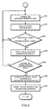
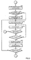
- Fig.6 is a flowchart showing request transmission and route guidance operation executed at the navigation apparatus. Step S50 has been described.
- arithmetic processing unit 101 stores the received data in memory 102 and executes the route guidance program 150 stored in memory 102 to carry out the route guidance by utilizing the received route guidance data (at a step S54). More particularly, a route map and landmarks are represented on display 106 and a voice guidance message is outputted through speaker 107 for guiding the driver to turn right or left at a crossing, for example.
- arithmetic processing unit 101 confirms the current vehicle position detected by position sensor 104 and executes the data request program 152.
- the current vehicle position reaches to a point before the terminal end of the received drive route by a predetermined distance (200m, for example)
- the next route guidance data preparation and transmission is requested (Yes at a step S56).
- the information center again executes such a series of operation as having been described in reference to the flowchart of Figs.2 and 3.
- it is then judged whether or not all of the segmental route guidance data have been received (at a step S58). After receiving all of the segmental data (Yes at S58), which means that the vehicle becomes ready to be guided along the planned drive route to the final destination, the operation of the flowchart of Fig.6 is over.
- FIG.7 An example of data communication between information center 10 and navigation apparatus 100 is shown in Fig.7.
- the current vehicle position, the destination and the guidance-demanding route length are transmitted from navigation apparatus 100 to information center 10.
- information center 10 executes the route search, segmentation, communicability judgment and route guidance data preparation in the manner described above in reference to the flowchart of Figs.2 and 3.
- Information center 10 then transmits the route guidance data to navigation apparatus 100, as shown by an arrow F3.
- Navigation apparatus 100 executes the actual route guidance operation in accordance with the received route guidance data, as shown by an arrow F4. Once some of the received segmental route guidance data becomes unnecessary, it is deleted from the route guidance data 160.
- navigation apparatus 100 again transmits the current vehicle position, the destination and the guidance-demanding route length to information center, as shown by an arrow F5. Similar data communication is repeated until the user of the navigation apparatus is successfully guided to the destination.
- information center 10 searches the next drive route at every time the navigation apparatus mounted on the vehicle is moved to a remote position (or when the vehicle reaches a request transmitting position, for example).
- information center 10 searches the next drive route at a predetermined time interval.
- information center 10 searches a most suitable drive route in reference to the updated, latest data in database 30.
- the searched drive route is divided into segmental data, which will be sequentially transmitted to navigation apparatus 100. Accordingly, in this modification, even if the vehicle remains standstill or moves at a very low speed, navigation apparatus 100 may receive the route guidance data from information center 10 at a predetermined time interval.
- a serious traffic accident may occur at a point which is located on the drive route now in operation, while the user of the navigation apparatus is taking a rest at a restaurant or a tearoom. Even in such a troublesome situation, the next route guidance data that navigation apparatus 100 may receive during the rest should reflect the latest data and, therefore, show the route detouring the point of the traffic accident.
- the navigation apparatus fails to receive the data. This may occur, for example, when the vehicle is running in an incommunicable area, when a great number of the requests are transmitted from other navigation apparatuses to the information center at substantially the same time, and when the system of the information center is broken down. In such case, the navigation apparatus can not guide the user of the navigation apparatus to the destination.
- the second embodiment therefore, aims at providing a system capable of guiding the user along a recommended drive route even if the navigation apparatus fails to receive the segmental route guidance data from the information center.
- the information center in this embodiment may have the same arrangement as that of the information center 10 in the above-described first embodiment.
- the information center stores the road data, such as road network data, which may be used to search a drive route for guiding the user to the destination.
- the navigation apparatus in this embodiment also stores the road data such as road network data for use in route searching operation, same as in the information center. Accordingly, in this embodiment, the navigation apparatus has a storage medium such as CD-ROM and DVD-ROM for storing the road data.
- the road data may be stored in memory 102, in which case no separate storage medium is required.
- the navigation apparatus makes communication with the information center, through a radio communication unit.
- the information center prepares the route guidance data in reference to road data 32 in database 30, which is transmitted to the navigation apparatus so that the user of the navigation apparatus is guided to the destination.
- Figs.8 and 9 show a flowchart of operation executed by the navigation apparatus in the system of this embodiment.
- the flowchart of Fig.8 is executed in response to input by the user to designate a destination and operation of a start switch to generate a route guidance request.
- the start switch may be mounted directly on a panel of the navigation apparatus, or mounted to a remote control device.
- the current vehicle position is determined as a starting point (at a step S500).
- no destination has been transmitted to the information center (No at a step S502).
- a destination inputted by the user. as well as the starting point determined at S500 are transmitted to the information center so as to request preparation and transmission of the segmental route guidance data from the starting point to the destination (at a step S504).
- a destination may be designated by inputting a telephone number or address indicative.
- the user inputs a telephone number indicative of any particular location, the inputted telephone number is transmitted to the information center (at S504).
- the information center reads out said location corresponding to said telephone number from the destination data 38 in database 30 and determines said location as a destination the user of the navigation apparatus wishes to go.
- the information center searches an optimum drive route from the starting point to the destination.
- the navigation apparatus receives, through the communication unit 108, the route guidance data prepared by the information center in reference to the road data 32 in database 30, so that the user of the navigation apparatus can be guided to the destination by this route guidance data prepared by and transmitted from the information center.
- Means for measuring a field intensity of a radio wave at the current vehicle position may be mounted on the navigation apparatus. When a field intensity measured by this means exceeds a predetermined threshold level, it may be judged that the road data 32 in database 30 is usable (Yes at S506).
- data usability may be affirmed when the navigation apparatus successfully receives the route guidance data from the information center within a predetermined period from transmission of the request at S504. Safe receipt of the route guidance data from the information center may be confirmed when the navigation apparatus receives a notification of completion of transmission from the information center.
- the navigation apparatus After executing steps S508-S516, in a case where the user doesn't reach the destination yet ( No at S516 ), the navigation apparatus repeats steps from S500.
- the navigation apparatus requests following route guidance data, , the navigation apparatus sends a request only with current vehicle position data as a new starting point because the navigation apparatus has already sent the destination data at the previous request (Yes at S502, S520).
- the user of the navigation apparatus is guided to the destination by utilizing the road data stored in the navigation apparatus.
- the navigation apparatus searches and plans a drive route to the destination and guides the user along the planned drive route to the destination.
- the navigation apparatus searches a drive route from the starting point (current vehicle position) to the destination in reference to the road data stored in the storage medium in the navigation apparatus (at a step S530).
- the starting point has been determined at S500.
- the destination may be one which has been inputted by the user.
- this data is combined with the drive route data searched at S530 to determine a drive route (at a step S534). Then, the navigation apparatus resets a drive distance counter (at a step S536) and executes route guidance (at a step S538).
- the navigation apparatus may have already received several times the route guidance data from the information center, while the vehicle is running over a considerable distance from the starting position, before being judged that database 30 is not usable.
- the user is being guided by the most recently received route guidance data.
- judgment at S532 produces an affirmative result so that the route guidance data now in operation is combined with the drive route data which has been determined at S530 to determine the drive route (at S534).
- the navigation apparatus resets a drive distance counter (at S536) and executes route guidance by which the user is guided along the drive route which has been determined at S530 (at S538).
- the navigation apparatus has a memory storing the road data to be used in route searching operation, apart from the same kind of data 32 stored in database 30 in the information center.
- the road data 32 in database 30 can not be used for route guidance (No at S506)
- the user is guided to the destination by utilizing the road data stored in the navigation apparatus. Consequently, the route guidance to the user may continue, without interruption, even if the navigation apparatus is incommunicable with the information center which makes impossible to use the road data stored in the information center.
- Incommunicability between the information and the navigation apparatus may occur when the vehicle is running in an incommunicable area, when a great number of the requests are transmitted from other navigation apparatuses to the information center at substantially the same time, or when the system of the information center is broken down.
- the de navigation apparatus While the user is being guided to the destination by utilizing the road data stored in the memory in the navigation apparatus, the de navigation apparatus sends a request to transmit the segmental route guidance data (at a step S546) at an interval of a predetermined drive distance (Yes at a step S542). If any cause of disusability of the road data 32 stored in the information center has been resolved at the time of transmitting a request to the information center (Yes at a step S548), the information center restarts the operation in response to receipt of the request to search a drive route in reference to the road data 32 stored therein.
- the vehicle runs into a communicable area, when the number of the requests transmitted from other navigation apparatuses is reduced, or when the system of the information center has been recovered, disusability of the road data 32 will be resolved.
- the route guidance data prepared by the information center is automatically transmitted to the navigation apparatus.
- the route guidance data prepared by the information center provides a drive route which may detour a point of traffic jam, traffic accident and road cunstruction, for example, because the road data 32 is updated by information from the external information collection unit 40.
- the route guidance data prepared by the information center comprises one or more of segmental data as described before in reference to Fig.5.
- the segmental route guidance data transmitted from the information center is combined with the route guidance data prepared by the navigation apparatus in reference to the road data stored therein to determined a drive route (at S510), along which the user is guided to the destination (at S512).
- Usability of the road data 32 at S548 may be judged substantially the same manner as described before in connection with judgment at S506.
- means for measuring a field intensity of a radio wave at the current vehicle position may be mounted on the navigation apparatus.
- the field intensity measured by this means exceeds a predetermined threshold level, it may be judged that the road data 32 is usable (Yes at S548).
- data usability may be confirmed when the navigation apparatus successfully receives the segmental route guidance data from the information center within a predetermined period from transmission of the request at S546. Safe receipt of the segmental route guidance data from the information center may be confirmed when the navigation apparatus receives a notification of completion of transmission from the information center.
- the navigation apparatus sends again a request to transmit the segmental route guidance data (at S546) at an interval of a predetermined drive distance (Yes at S542) until the user reaches to the destination (Yes at a step S540).
- the request is sent to the information center at a predetermined drive distance (of 2km, for example), it may be sent at a predetermined time interval (of 10 minutes, for example).
- the navigation apparatus may send a request automatically just after confirming usability of road data 32.
- the route guidance data thus prepared by the information center is transmitted to the navigation apparatus, so that S510 and the succeeding steps are executed.
- the vehicle runs in a distance of the order of 1km between sending the request to the information center and receiving the route guidance data from the information center. Accordingly, a point of 1km ahead of the current vehicle position is determined as the starting point (at a step S544).
- the destination is inputted by the user (at S504).
- the user inputs a telephone number indicative of a destination, this is transmitted to the information center.
- the information center has the database 30 storing the destination data 38 in which almost every location of institution or place is correlated with its telephone number and/or address. Accordingly, in reference to the inputted telephone number, a corresponding location of institution or place may readily be read out from the destination data 38 and is determined as a destination that the user wishes to go.
- the user may designate a destination by inputting its address.
- the information center receives the inputted information (address) and reads out a corresponding location of institution or place from the destination data 38, which is determined as a destination.
- Data for representing a picture by which the telephone number and/or the address is inputted may be stored in the memory in the navigation apparatus, or obtained by transmission from the information center.
- the information center can not receive the inputted data and, therefore, nor determine a corresponding destination in reference to the destination data 38 stored therein. Accordingly, no route searching operation may be executed.
- Such incommunicable situation may occur, for example, when the vehicle is running in an incommunicable area. when a great number of the requests are transmitted from other navigation apparatuses to the information center at substantially the same time, and when the system of the information center is broken down.
- second destination data is stored in the navigation apparatus.
- the second destination data almost every location of institution or place is correlated with its telephone number and/or address, as in the first destination data 38 in the information center.
- the information center in this embodiment may have the same arrangement as that of the information center 10 in the first embodiment.
- the information center stores the road data, such as road network data, which may be used to search a drive route for guiding the user to the destination.
- the information center also stores the destination data 38 in which almost every location of institution or place is correlated with its telephone number and/or address.
- the navigation apparatus makes communication with the information center, through a radio communication unit 108.
- the telephone number and/or address inputted by the user through an input device 105 is transmitted to the information center.
- the information center thus determines a specific destination which corresponds to the inputted telephone number and/or address in reference to the destination data 38, so that the user may be guided to the destination.
- the navigation apparatus detects whether or not the destination data 38 in the information center can be used. When it is detected that the destination data 38 is not usable, the navigation apparatus operates to determine a destination in reference to the second destination data stored in the memory in the navigation apparatus.
- means for measuring a field intensity of a radio wave at the current vehicle position is mounted on the navigation apparatus.
- the field intensity measured by this means exceeds a predetermined threshold level, it may be judged that the destination data 38 in the information center is usable. On the contrary, when the measured field intensity is below the predetermined threshold level, this would means that the destination data 38 is not usable.
- second destination data is stored in the navigation apparatus.
- the second destination data almost every location of institution or place is correlated with its telephone number and/or address, same as in the first destination data 38 in the information center.
- a destination can be determined in reference to the second destination data stored in the memory in the navigation apparatus. Consequently, even if the navigation apparatus is incommunicable with the information center due to being in an incommunicable area, an overcrowded communication with the information center, a system breakdown in the information center, for example, a destination can be determined, which enables the user to be guided to the destination.
- the road data in the information center when the road data in the information center is found to be usable, it is used to guide the user of the navigation apparatus mounted on the vehicle to the destination, whereas when it is found to be disusable, another road data stored in the memory in the navigation apparatus is used to guide the user to the destination.
- the navigation apparatus has the same arrangement as that of the second embodiment, except that it further comprises means for requesting the information center to prepare and transmit the segmental route guidance data when the vehicle has been strayed from the drive route which has been determined in reference to the road data stored in the information center or in the navigation apparatus.
- the information center in this embodiment may have the same arrangement as that of the information center 10 in the second embodiment.
- Fig.10 is a flowchart illustrating operation executed by the navigation apparatus when the vehicle has been strayed from the drive route which has been determined by the information center from the road data stored therein.
- the operation begins with a step S600 in which the navigation apparatus receives the segmental route guidance data from the information center.
- the user of the navigation apparatus mounted on the vehicle is guided to the destination by the received segmental route guidance data (at a step S602).
- a voice message such as "You are around the destination. Guidance will be finished.” is outputted through the speaker 107 with or without an appropriate image on the display 106 (at a step S616), and the operation terminates. It may be judged that the vehicle has reached around the destination, when a distance between the current vehicle position and the destination becomes shorter than a threshold value.
- the segmental route acquisition request together with the current vehicle position (as the starting point), are transmitted to the information center (at a step S608).
- step S610 In response to receipt of the segmental route acquisition request from the navigation apparatus, usability of the road data 32 in the information center is judged (at a step S610).
- the information center prepares new route guidance data and transmits it to the navigation apparatus.
- the navigation apparatus guides the user along a drive route which is determined by the received route guidance data in combination with the previous route guidance data (at S602).
- the navigation apparatus searches, in reference to the road data stored in the own memory, a recovery route from the current vehicle position to a position on the prearranged drive route along which the user should be guided to the destination at S602.
- the recovery route may be one providing the shortest trip from the current vehicle position to the position on the prearranged drive route.
- a new drive route is determined by combining the searched recovery route data with the prearranged route data (at a step S614), and the navigation apparatus guides the user along the new drive route (at S602).
- the road data is stored not only in a memory provided in the information center but also in another memory provided in the navigation apparatus, and the navigation apparatus is provided with means for requesting the information center to prepare and transmit the segmental route guidance data when the vehicle has been strayed from the drive route which has been determined in reference to the road data stored in the information center or in the navigation apparatus.
- the user can be guided to the destination using the road data stored in the memory in the navigation apparatus.
- location of any institution or place to be designated as a destination is correlated with its telephone number and/or address in the destination data which is stored in the information center and also in the navigation apparatus.
- the memory in the navigation apparatus has a storage capacity much smaller than the memory in the information center. Therefore, it may occur that a destination which corresponds to the inputted telephone number or address is not stored in the memory in the navigation apparatus.
- the inputted telephone number of address is transmitted to the information center so that the information center may identify a corresponding destination in reference to the destination data, having much greater data volume.
- the user when it is detected that the destination data in the information center is not usable and when a destination corresponding to the inputted telephone number or address is not found in the destination data in the memory in the navigation apparatus, the user is guided to an area which may be identified by a part of the inputted telephone number (area code, for example) or a part of the inputted address (name of country, township, city, town, village, street, avenue, zip code, for example).
- the user when it is detected that the destination data in the information center is not usable and when a destination is designated by inputting its ten-digit telephone number of"123-456-xxxx" which is unfortunately not found in the destination data in the memory in the navigation apparatus, the user is guided to an area which corresponds to the first six-digit number of "123-456".
- the user when it is detected that the destination data in the information center is not usable and when a destination is designated by inputting its address of "xxxx, Alexandria, Virginia” which is unfortunately not found in the destination data in the memory in the navigation apparatus, the user is guided to the city ofAlexandria, Virginia.
- the memory device in the navigation apparatus stores a plurality of locations each representative of an area which is identified by a part of the inputted telephone number or address.
- the navigation apparatus refers to the own destination data to read out a representative location corresponding to a part of the inputted information, so that the user may be guided to the representative location.
- provisional guidance may not always meet the user's demand and will hereinbelow referred to as provisional guidance.
- Fig. 11 is a flowchart illustrating operation executed by the information center when receiving the segmental route acquisition request from the navigation apparatus (at S546).
- the segmental route acquisition request is automatically transmitted from the navigation apparatus when the vehicle enters a communicable area, for example, during execution of the provisional guidance.
- the information center When the information center receives the segmental route data acquisition request, as well as the inputted telephone number specifying a destination the user wishes to go, the current vehicle position, a flag indicating execution of the provisional guidance, an ID of a road on which the vehicle locates, etc. (Yes at a step S750), it searches a location corresponding to the entire telephone number in reference to the destination data 38 (at a step S752).
- the information center judges if the provisional guidance is being executed in reference to the flag (at a step S754). If the provisional guidance is not executed at this time (No at S754), it determines the current vehicle position as a starting point (at a step S756) and searches a route from this starting point to the location found at S752 and prepare the segmental route guidance data (at a step S758), which is transmitted to the navigation apparatus in response to the segmental route data acquisition request (at a step S760). In preferable application, when the information center successfully finds a accurate location which corresponds to the entire telephone number inputted by the user, it then searches detailed information regarding the location, which is also transmitted to the navigation apparatus.
- the information center estimates the arrival time on the user at the theater based on the traffic jam or accident information so that film programs which will start after arrival are noticed to the user of the navigation apparatus.
- An example of the film programs is "A new film entitled "xxx" is now showing at the ABC theater. The film begins at 11:30. 13:55, 16:10 and 18:45. You will be in time for the second show.”
- the inputted telephone number designates a supermarket for another example, its business hours may be transmitted to the navigation apparatus.
- the user of the navigation apparatus may be given a notice of "The supermarket you want to go is open until 10 p.m.”, "The supermarket is closed today.”, "The supermarket will be closed at the estimated time of arrival. Another neighbor supermarket is still open.”, for example.
- step S754 when the provisional guidance has been executed (Yes at S754), the terminal end of the vehicle-locating road, which is specified by ID number transmitted from the navigation apparatus, is set as a starting point (at a step S762), and a drive route from this starting point to the location confirmed at S752 is searched out to prepare the segmental route guidance data (at S758), which is transmitted to the navigation apparatus (at S760). It is to be noted that the foregoing operation is similarly applicable when the user designates a destination by inputting its address.
- the user is guided to an area which may be identified by a part of the inputted telephone number (area code, for example) or a part of the inputted address (name of country, township, city, town, village, street, avenue, zip code, for example).
- the navigation apparatus even if the navigation apparatus is not communicable with the information center due to being in an incommunicable area, an overcrowded communication with the information center, a system breakdown in the information center, for example, which makes it impossible to use the destination data stored in the information center, and even when a destination corresponding to the inputted telephone number or address is not found in the destination data in the memory in the navigation apparatus, the user may be guided to the destination where the user wants to go.
- the road data stored in the memory in the information center is used to prepare the route guidance data, which is transmitted to the navigation apparatus to guide the user to the destination.
- the navigation apparatus can not use the road data stored in the information center in actual guidance.
- another road data and communicable area data are used to search a route, along which the user is guided to enter a communicable area.
- a field intensity of a radio wave measured by measurement means in the navigation apparatus is below a threshold level, it may be detected that the navigation apparatus is in an incommunicable area.
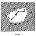
- the communicable area data is the data to specify a plurality of communicable areas where the navigation apparatus can communicate with the information center.
- the communicable area data may specify incommunicable areas where the navigation apparatus can not or hardly communicate with the information center.
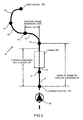
- the communicable area data is stored in the memory in the navigation apparatus as a combination of plural coordinates P1-P6 shown by way of example in Fig.12. In this example, an area surrounded by segments P1-P2, P2-P3, P3-P4, P4-P5, P5-P6 and P6-P1 indicates an incommunicable area.
- the navigation apparatus automatically transmits a request for route guidance data and receives the route guidance data to and from the information center, as in usual operation.
- the inputted destination has detailed information such as film programs (for theaters) and business hours (for supermarket), such detailed information may also be transmitted to the navigation apparatus, as well as the route guidance data.
- the navigation apparatus receives the detailed information of the destination, it is noticed to the user through the display 106 and/or speaker 107.
- the navigation apparatus and the information center in this embodiment may have the same arrangement in the third embodiment.
- the navigation apparatus when it is detected that the navigation apparatus is in an incommunicable area based on, for example, a field intensity of a radio wave at the current vehicle position, another road data and communicable area data, both stored in a memory in the navigation apparatus, are used to search a route, along which the user on the vehicle is guided to enter a communicable area.
- the user of the navigation apparatus mounted on the vehicle is usually guided to the destination by the route guidance data prepared by the information center in reference to the road data stored therein and transmitted therefrom to the navigation apparatus, even if it becomes impossible to use the route guidance data prepared by the information center, which may be caused while the navigation apparatus is in an incommunicable area, the user can still be guided to a communicable area by utilizing the route searching stored in the memory in the navigation apparatus.
- the navigation apparatus After entering the communicable area, the navigation apparatus becomes again communicable with the information center so that it acquires a new route guidance data which may detour a point of traffic jam, accident and construction in view of the latest data stored in an updatable memory in the information center.
- Input of the entire information (telephone number or address) indicative of a destination is a precondition in the third embodiment.
- the information center receives an ten-digit telephone number of "123-456-xxxx" inputted by the user, it refers to the destination data 38 to find a corresponding location of the place or facility which is determined as a destination.
- an auxiliary destination data stored in a memory in the navigation apparatus is used to determine a corresponding destination.
- This embodiment is applicable when not the entire telephone number but only a part thereof (area code, for example) is inputted by the user. In this embodiment, the user is guided to an area which may be identified by a the inputted part of the telephone number. When, thereafter, the entire telephone number is inputted, the user is then guided to a destination corresponding to the inputted entire telephone number.
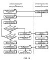
- the navigation apparatus sends a destination-selecting-menu display request to the information center (at a step S800).
- the information center transmits a destination-selecting-menu to the navigation apparatus (at a step S802).
- the navigation apparatus receives the destination-selecting-menu from the information center (at a step S804), the menu is displayed at the display 106.
- the navigation apparatus judges whether or not some destination area can be specified at each time of inputting a digit (at a step S810).
- the memory in the navigation apparatus stores a plurality of locations representing an area which is identified by a part of the inputted telephone number, which may be an area code.
- a part of the inputted telephone number which may be an area code.
- the memory stores the representative location of the state of Virginia, and said representative location is determined as a tentative destination when the first three digits "123” (we assume, in this example, that the area code "123” is the area code of the state of Virginia ) has been inputted by the user.
- a drive route to a representative location in the specified destination area is searched (at a step S812) and local route guidance data is prepared (at a step S814). Then it awaits commands for start guiding from the user (at a step S816).
- the navigation apparatus starts the guidance operation so that the user is guided to the representative location.
- the navigation apparatus awaits input of an additional digit (at S806).
- the navigation apparatus sends a destination searching request to the information center (at a step S818). If, at this step, it is detected that destination specifying data 38 in the information center is not usable because of being in an incommunicable area, for example, the navigation apparatus refers to its own destination specifying data to search and determine a location to be identified by the inputted entire telephone number, searches a drive route to said location, and starts guidance operation to guide the user along the searched drive route (at a step S820).
- the information center in response to receipt of the destination searching request from the navigation apparatus (at S818), refers to the own destination specifying data 38 to search and determine a location to be identified by the inputted entire telephone number (at a step S822), searches a drive route to said location (at a step S824), prepares route guidance data (at a step S826) and transmits the route guidance data to the navigation apparatus (at a step S828).
- the navigation apparatus In receipt of the route guidance data from the information center (at a step S830), the navigation apparatus executes guidance operation to guide the user along the drive route searched by the information center (at a step S832).
Landscapes
- Engineering & Computer Science (AREA)
- Radar, Positioning & Navigation (AREA)
- Remote Sensing (AREA)
- Automation & Control Theory (AREA)
- Physics & Mathematics (AREA)
- General Physics & Mathematics (AREA)
- Navigation (AREA)
- Traffic Control Systems (AREA)
- Instructional Devices (AREA)
- Mobile Radio Communication Systems (AREA)
Abstract
The information center has the latest road data. The information center prepares recommended route guidance data, in reference to said latest road data, for guiding the mobile unit from current position to a destination in respond to a request from the mobile unit. Said recommended route guidance data is divided into a plurality of segmental data which is formed to be usable independently in the mobile unit, and transmitted to the mobile unit, and then used for guiding the user of the mobile unit to the destination. The mobile unit has a road data similar to the road data in the information center and means for detecting whether or not the mobile unit can communicate with the information center. In a case where the mobile unit can not communicate with the information center, the mobile unit prepares a route guidance data in reference to the road data in the mobile unit, and guides the user of the mobile unit using said prepared route guidance data. In this way, it becomes possible to guide the user even in the case that the mobile unit can not communicate with the information center. Even in a case where a communication link is disrupted during transmission of route guidance data to the mobile unit, the mobile unit can effectively prepare whole route guidance data in combination with already-received route guidance data and additionally prepared route guidance data in reference to the road data in the mobile unit because of the already-received route guidance data is formed to be usable independently.
Description
- The present invention relates to a communication route guidance system for guiding a mobile unit to a destination and, more particularly to a communication route guidance system wherein communication is made between an information center and at least one mobile unit, both storing road data. Specifically, the mobile unit has a communication terminal mounted thereon.
- Japanese patent laid-open publication No.10-19588 discloses an example of the prior art communication route guidance system wherein map image data, recommended route data (or optimum route data) and other data necessary in route guidance are transmitted from an information center to a mobile unit.
- In this system, the information center operates, in response to a request from the mobile unit, to read out necessary data from database and prepare the map image data. It also makes route search operation to prepare the optimum route data. The information center then transmits the map image data and the optimum route data thus prepared to the mobile unit. The mobile unit guides the user of the mobile unit to the destination in accordance with such data transmitted from the information center.
- In some case, however, the mobile unit is not capable of receiving data from the information center when the mobile unit is in an area in which the mobile unit is not or hardly communicable with the information center. Such an area is hereinbelow referred to as "incommunicable area". Such trouble may also occur when a system in the information center becomes broken down.
- Accordingly, it is a primary object of the present invention to provide a novel communication route guidance system which is capable of guiding a mobile unit to a destination even when the mobile unit is in an incommunicable area or the system in the information center becomes broken down.
- To achieve the above objects, in accordance with a first aspect of the present invention, there is provided a communication route guidance system wherein an information center transmits route information to a mobile unit for guiding said mobile unit from its current position to a destination, in response to a request from said mobile unit,
- said information center comprising:
- first communication means for transmitting and receiving data to and from said mobile unit;
- first memory means for storing first road data;
- first route search means for planning first route guidance data for guiding said mobile unit from said current position to said destination in reference to said first road data stored in said first memory means, each time when said information center receives said request from said mobile unit, said current position and said destination being transmitted from said mobile unit through said first communication means; and
- data dividing means for dividing said first route guidance data into a plurality of segmental data, each segmental data being usable in said mobile unit as an independent route information for guiding said mobile unit from one extreme end of said segmental data to the other end thereof;
- said mobile unit comprising:
- second communication means for transmitting and receiving data to and from said information center;
- second memory means for storing second road data;
- second route search means for planning second route guidance data for guiding said mobile unit from said current position to said destination, in reference to said second road data stored in said second memory means;
- third memory means for storing at least one of said segmental data transmitted from said information center through said first and second communication means;
- sensor means for detecting whether data is communicable with said information center through said first and second communication means; and
- route guidance means for guiding said mobile unit to said destination in accordance with at least one of said second route guidance data planned by said second route search means and said segmental data stored in said third memory means, said route guidance means guiding said mobile unit to said destination in accordance with said second route guidance data when said sensor means detects incommunicability between said mobile unit and said information center.
-
- In a preferred embodiment of the first aspect of the present invention, said information center further comprises information collection means for obtaining the latest traffic and road information, said first road data stored in said first memory means being updated in response to said latest traffic and road information obtained by said information collection means.
- In another preferred embodiment of the first aspect of the present invention, when said mobile unit has been guided by said second route guidance data planned by said second route search means and when said sensor means detects that data becomes communicable with said information center, said first route search means plans a new route guidance data for guiding said mobile unit from the current position of said mobile unit to said destination in response to said request from said mobile unit, said new route guidance data being divided by said data dividing means into a plurality of said segmental data which are transmitted to said mobile unit so that said segmental data are stored in said third memory means.
- In this embodiment, said sensor means may comprise measurement means for measuring field intensity of a radio wave in data transmission from said information center; and means for judging that data is incommunicable with said information center when said measured field intensity is below a predetermined threshold level. Alternatively, said sensor means may comprise means for judging that data is incommunicable with said information center when said mobile unit receives none of said segmental data from said information center within a predetermined time period after transmitting said request to said information center. Said sensor means may also comprise communicable area data memory means for storing data specifying communicable areas in which said mobile unit is communicable with said information center; and means for judging, in accordance with said data stored in said communicable area data memory means, that there is incommunicability between said mobile unit and said information center when said mobile unit is outside of any of said communicable areas.
- In accordance with a second aspect of the present invention, there is provided a communication route guidance system wherein an information center transmits route information to a mobile unit for guiding said mobile unit from its current position to a destination, in response to a request from said mobile unit,
- said information center comprising:
- first communication means for receiving said current position and said destination from said mobile unit and transmitting said segmental data to said mobile unit;
- first memory means for storing road data;
- route search means for planning route guidance data for guiding said mobile unit from said current position to said destination in reference to said road data stored in said first memory means;
- data dividing means for dividing said route guidance data into a plurality of segmental data, each segmental data being usable in said mobile unit as an independent route information for guiding said mobile unit from one extreme end of said segmental data to the other end thereof
- communicable area data memory means for storing data specifying communicable areas in which said mobile unit is communicable with said information center through said first communication means; and
- transmission route length determining means for determining the number in a continuous series of said segmental data to be transmitted at a time to said mobile unit, so as to locate a fore extreme end of said continuous series of said segmental data within one of said communicable areas;
- said mobile unit comprising:
- second communication means for transmitting said current position and said destination to said information center and receiving said segmental data from said information center;
- second memory means for storing said segmental data; and
- route guidance means for guiding said mobile unit to said destination in accordance with said segmental data stored in said second memory means.
-
- In a preferred embodiment of the second aspect of the present invention, said information center further comprises information collection means for obtaining the latest traffic and road information, said road data stored in said first memory means being updated in response to said latest traffic and road information obtained by said information collection means.
- In another preferred embodiment of the second aspect of the present invention, said mobile unit transmits said request to said information center for being guided to said destination, each time when a length of the remaining route guidable by said continuous series of said segmental data which said mobile unit has received in the last segmental data transmission from said information center becomes shorter than a predetermined distance, and said route search means plans said route guidance data each time when said information center receives said request from said mobile unit.
- In still another preferred embodiment of the second aspect of the present invention, said mobile unit transmits said request to said information center at a predetermined periodic interval or a predetermined distance interval of movement of said mobile unit, and said route search means plans said route guidance data for guiding said mobile unit from said current position to said destination. each time when said information center receives said request from said mobile unit.
- In still another preferred embodiment of the second aspect of the present invention, said route search means plans said route guidance data for guiding said mobile unit from said current position to said destination at a predetermined periodic interval or a predetermined distance interval of movement of said mobile unit.
- In accordance with a third aspect of the present invention, there is provided a communication-route guidance system wherein an information center transmits route information to a mobile unit for guiding said mobile unit from its current position to a destination, in response to a request from said mobile unit,
- said information center comprising:
- first communication means for transmitting and receiving data to and from said mobile unit;
- first memory means for storing first road data;
- first route search means for planning first route guidance data for guiding said mobile unit from said current position to said destination in reference to said first road data stored in said first memory means, said current position and said destination being transmitted from said mobile unit through said first communication means;
- data dividing means for dividing said first route guidance data into a plurality of segmental data, each segmental data being usable in said mobile unit as an independent route information for guiding said mobile unit from one extreme end of said segmental data to the other end thereof; and
- transmission route length determining means for determining the number in a continuous series of said segmental data to be transmitted at a time to said mobile unit, so as to locate a fore extreme end of said continuous series of said segmental data within one of said communicable areas;
- said mobile unit comprising:
- second communication means for transmitting and receiving data to and from said information center;
- second memory means for storing second road data;
- second route search means for planning second route guidance data for guiding said mobile unit from said current position to said destination, in reference to said second road data stored in said second memory means;
- third memory means for storing at least one of said segmental data transmitted from said information center through said first and second communication means;
- route guidance means for guiding said mobile unit to said destination along a guide route defined by at least one of said second route guidance data planned by said second route search means and said segmental data stored in said third memory means;
- first sensor means for detecting whether data is communicable with said information center through said first and second communication means; and
- second sensor means for detecting that said mobile unit has strayed from said guide route;
- wherein said second route search means being responsive to both detection by said second sensor means that said mobile unit has strayed from said guide route and by said first sensor means that data is incommunicable between said mobile unit and said information center to plan restoration route guidance data for guiding and returning said mobile unit to said guide route along which said mobile unit had been guided by said route guidance means before detection by said second sensor means that said mobile unit has strayed from said guide route.
-
- In a preferred embodiment of the third aspect of the present invention, said information center further comprises information collection means for obtaining the latest traffic and road information, said first road data stored in said first memory means being updated in response to said latest traffic and road information obtained by said information collection means.
- In another preferred embodiment of the third aspect of the present invention, said mobile unit transmits said request to said information center for being guided to said destination, each time when a length of the remaining route guidable by said continuous series of said segmental data which said mobile unit has received in the last segmental data transmission from said information center becomes shorter than a predetermined distance, and said first route search means plans said first route guidance data each time when said information center receives said request from said mobile unit.
- In still another embodiment of the third aspect of the present invention, said mobile unit transmits said request to said information center at a predetermined periodic interval or a predetermined distance interval of movement of said mobile unit, and said first route search means plans said first route guidance data for guiding said mobile unit from said current position to said destination each time when said information center receives said request from said mobile unit.
- In still another embodiment of the third aspect of the present invention, said first route search means plans said first route guidance data for guiding said mobile unit from said current position to said destination at a predetermined periodic interval or a predetermined distance interval of movement of said mobile unit.
- In accordance with a fourth aspect of the present invention, there is provided a communication route guidance system wherein an information center transmits route information to a mobile unit for guiding said mobile unit from its current position to a destination. in response to a request from said mobile unit,
- said information center comprising:
- first memory means for storing first location data capable of specifying a location by designation of at least one of telephone number and address thereof and
- first route search means for planning first route guidance data for guiding said mobile unit from said current position to said destination which is determined in reference to said first location data stored in said first memory means;
- said mobile unit comprising:
- input means for inputting at least one of telephone number and address, relating to said destination, as destination information;
- communication means for transmitting said current position and said destination information to said information center and receiving said first route guidance data from said information center;
- second memory means for storing second location data capable of specifying a location by designation of said destination information;
- sensor means for detecting whether data is communicable with said information center through said communication means;
- second route search means for planning second route guidance data for guiding said mobile unit from said current position to said destination in accordance with said second location data stored in said second memory means, when said sensor means detects that said information inputted by said input means is untransmittable to said information center; and
- route guidance means for guiding said mobile unit to said destination in accordance with at least one of said first and second route guidance data.
-
- In a preferred embodiment of the fourth aspect of the present invention, when said mobile unit has been guided by said second route guidance data planned by said second route search means and when said sensor means detects that data becomes communicable with said information center, in response to said request from said mobile unit, said first route search means plans a new route guidance data for guiding said mobile unit from the current position of said mobile to said destination, whereby said route guidance means guides said mobile unit in accordance with said new route guidance data planned by said first route search means and transmitted from said information center to said mobile unit.
- In another preferred embodiment of the fourth aspect of the present invention, said second location data stored in said second memory means contains data specifying a representative location within an area including a location to be designated by input of telephone number and/or address through said input means.
- In still another preferred embodiment of the fourth aspect of the present invention, said sensor means comprises measurement means for measuring field intensity of a radio wave in data transmission from said information center; and means for judging that data is incommunicable with said information center when said measured field intensity is below a threshold level.
- In still another preferred embodiment of the fourth aspect of the present invention, said sensor means comprises means for judging that data is incommunicable with said information center when said mobile unit receives none of said first route guidance data from said information center within a predetermined time period after transmitting said request to said information center.
- In still another preferred embodiment of the fourth aspect of the present invention, said sensor means comprises communicable area memory means for storing data specifying communicable areas in which said mobile unit is communicable with said information center; and means for judging, in accordance with said data stored in said communicable area memory means, that there is incommunicability between said mobile unit and said information center when said mobile unit is outside of any of said communicable areas.
- Typical examples for the mobile unit mentioned above are not only a navigation apparatus mounted on a vehicle and a handy navigation apparatus for a pedestrian, but also personal computer, laptop computer, personal digital assistant ( PDA ), cellular phone, and pager , with which proper devices are added. Hereinbelow, in drawings and description, the words " a navigation apparatus ( mounted on a vehicle )" will be used as a mobile unit.
- The above and other objects of the present invention will become apparent from the following description when read in conjunction with the accompanying drawings in which:
- Fig.1 is a block diagram showing an arrangement of a communication route guidance system embodying the present invention;
- Figs.2 and 3 show a flowchart of route guidance data preparation and transmission operation executed at the information center;
- Fig.4 is an explanatory view showing a manner of dividing the planned drive route, with an example of contents of a divided, segmental data;
- Fig.5 is a plan view diagrammatically showing relationship between a planned route and a plurality of segmental routes obtained by division of the planned drive route;
- Fig.6 is a flowchart showing request transmission and route guidance operation executed at the navigation apparatus mounted on the vehicle;
- Fig.7 shows an example of data communication between the information center and the navigation apparatus;
- Figs.8 and 9 show a flowchart of operation executed at the navigation apparatus when road data stored in the information center can not be used by the navigation apparatus;
- Fig.10 is a flowchart of operation executed at the navigation apparatus when the vehicle has been strayed from the planned drive route;
- Fig. 11 is a flowchart of operation executed at the information center when receiving data indicating a telephone number and/or an address from the navigation apparatus;
- Fig.12 is an explanatory view showing data stored in a memory in the navigation apparatus, said data being used to specify an incommunicable area; and
- Fig.13 is a flowchart of operation executed both at the information center and the navigation apparatus when only a part (an area code, for example) of a telephone number is inputted.
-
- First, in reference to Fig.1, the overall arrangement of a communication route guidance system of this embodiment will be described. The system comprises an
information center 10 and anavigation apparatus 100 mounted on a vehicle. - In
information center 10, there is acommunication unit 12 including a transmitter and a receiver, which allows data transmission tonavigation apparatus 100 as well as data receiving therefrom.Communication unit 12 may comprises car phone, cellular phone, portable handy phone system (PHS), etc. Anarithmetic processing unit 14 includes a central processing unit (CPU) 16 that executes various processing and control operation and amemory 18 that stores various programs and data. - More particularly,
memory 18 stores aroute search program 20 for searching a route from a current vehicle position (that is a vehicle position at the time the navigation operation starts or a starting point) to a destination (where the navigation operation terminates), segmentation program 22 for dividing a planned route into segmental routes and determining a route length to be transmitted tonavigation apparatus 100, guidance data search program 24 for searching, extracting and editing guidance data corresponding to the route length determined by the segmentation program 22, communicability judgment program 25 for judging whether or not data transmission is possible,system control program 26 for controlling and managing the overall operation, and other programs to be executed byinformation center 10.Memory 18 has also a working area for use in execution of these programs. -
Database 30 stores road data 32 for searching a route to the destination, guidance data 34 comprising plural data for guiding the user of the navigation apparatus to the destination along a searched route,communicable area data 36 comprises plural data regarding communicable areas, destination specifying data 38 comprising coordinates of various points in combination with their telephone numbers and/or addresses which may be used in determination of destinations, and other data to be used in route search and route guidance operation. The road data 32 typically comprises a road network data including crossing data and node data. The guidance data 34 includes map data of respective crossings and roads, landmark data and voice guidance data. Thecommunicable area data 36 is the data for specifying the area in which the navigation apparatus can communicate with the information center. - An external
information collection unit 40 is connected todatabase 30 for obtaining the latest information regarding roads, traffic and communication conditions from other information center by means of telephone lines or other communication devices. Typical examples of the latest information includes information of traffic jams, traffic accidents, road repairing, traffic restriction, newly-constructed roads, newly-established institutions, change of communicable and/or incommunicable areas, etc. The latest information is used to update data stored indatabase 30. Some kinds of the latest information such as information of traffic jams, traffic accidents, road repairing, traffic restriction, newly-constructed roads, newly-established institutions, etc. should be correlated with location and date (and time) of its occurrence. For example, the traffic jam information should be obtained with location and date-and-time where and when a traffic jam occurs. This is also applicable to the traffic accident information. - In
navigation apparatus 100, there is anarithmetic processing unit 101 which typically comprises a central processing unit (CPU). Aprogram storing area 102A of amemory 102 stores aroute guidance program 150 for representing a drive route and landmarks therearound on adisplay 106 and outputting a route guidance message through a voice outputting device or aspeaker 107 in accordance with route guidance data transmitted frominformation center 10, adata request program 152 for requesting new route guidance data for guiding the user of the navigation apparatus along a next drive route by comparison between the current vehicle position and the route guidance data now in operation, acontrol program 154 for controlling the overall operation, and other programs to be executed byarithmetic processing unit 101. -
Data storing area 102B ofmemory 102 has a working area for use in execution of those programs. Additionally, route guidance data 160 (which comprises route data and guidance data) transmitted frominformation center 10, ID data 162 identifyingnavigation apparatus 100, vehicle position data 164 (which comprises latitude and longitude of vehicle position) detected by aposition sensor 104 are also stored indata storing area 102B. - The vehicle position is detected by
position sensor 104 at predetermined time intervals.Vehicle position data 164 comprises a series of the vehicle positions obtained by the latest, several-time detection byposition sensor 104. For example, a series of the past vehicle positions within a predetermined distance, or a predetermined number of the past vehicle positions may be stored asvehicle position data 164. Onceposition sensor 104 detects a new vehicle position,vehicle position data 164 is updated such that said new vehicle position is added as the latest data and the oldest one is removed. A series of the past vehicle positions represents a track of movement of the vehicle. The track of movement of the vehicle may be used in so-called map-matching operation to specify a road on which the vehicle is running. -
Position sensor 104 has a Global Positioning System (GPS) receiver which receives radio waves from plural earth satellites to determine absolute coordinates of the vehicle current position.Position sensor 104 may also have a speed meter and a compass, both are used to determine a relative position of the vehicle by dead reckoning method. The relative position determined by those sensors may be used in a case when no radio waves is receivable by the GPS receiver or the vehicle is running through a tunnel. The relative vehicle position may also be used to eliminate an error of the absolute vehicle position detected by the GPS receiver. - An
input device 105 may include various switches, a touch panel attached to a front panel ofdisplay 106, a remote control unit and a voice input unit. In data inputting operation with the touch panel, a touch by a user's finger on a particular icon shown ondisplay 106 will input corresponding data or command. The voice input unit receives and recognized-the user's voice that corresponding data or command may be inputted. -
Display 106 may comprise a liquid crystal display (LCD) or a cathode-ray tube (CRT) with the above-described touch panel. Acommunication unit 108 includes a transmitter and a receiver, which allows data transmission toinformation center 10 as well as data receiving therefrom. As described before in connection withcommunication unit 12 ininformation center 10,communication unit 108 may comprises car phone, cellular phone, PHS, etc. - Figs.2 and 3 show a flowchart of route guidance data preparation and transmission operation executed at the information center. Before execution of this operation,
control program 154 stored inmemory 102 has been executed byarithmetic processing unit 101 innavigation apparatus 100. When thedata request program 152 stored inmemory 102 is executed in response to the user's input operation throughinput device 105, data including the current vehicle position detected byposition sensor 104, the destination. and the route length along which the navigation apparatus requires route guidance frominformation center 10 are transmitted toinformation center 10 through communication unit 108 (as shown by a step S50 in a flowchart of Fig.6 to be described later). An ID code distinguishing the own navigation apparatus from other navigation apparatus is also transmitted toinformation center 10 at the same time.Information center 10 receives these data through communication unit 12 (Yes at a step S10) and transfers the same toarithmetic processing unit 14. Communication betweeninformation center 10 andnavigation apparatus 100 may preferably be made by packet transmission. -
Arithmetic processing unit 14 ininformation center 10 executes thesystem control program 26 stored inmemory 18. In response to receipt of the above-described data, theroute search program 20 stored inmemory 18 is executed byCPU 16 to start route search operation. More particularly, the current vehicle position data and the destination data are picked out from the received data (at a step S12) and a particular destination is determined from the destination data (at a step S14). For example, in a case where the destination is pointed by a telephone number or an address, a particular destination is determined in reference to the destination specifying data 38 indatabase 30. - When a guidance-demanding route length is specified in the received data (Yes at a step S16), this is preserved in
memory 18 as route length data 27 and a drive route from the current vehicle position to the destination is searched and planned (at a step S18). On the contrary, when no route data length is specified in the received data (No at S16), a predetermined initial value is preserved as the route length data 27 (at a step S22), followed by drive route search operation at S18. The drive route search operation is made in reference to the road data 32 indatabase 30 which include crossing data, node data, etc. The drive route search operation may be made in such manner as known in Japanese patent laid-open publication No.1-173297 and 1-173298, for example, to determine a recommended drive route, which may be a shortest one from the current position to the destination. - In this embodiment, a drive route from the current position to the destination is determined each
time information center 10 receives the request fromnavigation apparatus 100. As described before,database 30 ininformation center 10 has the latest contents because they are updated with information obtained by externalinformation collection unit 40. By carrying out the drive route search operation in response to each receipt of the request fromnavigation apparatus 100, it will be possible thatnavigation apparatus 100 always receives a most suitable drive route which may detour a point of traffic jam, road construction, traffic accident, for example, and guidance data for being guided along said drive route. - Then,
CPU 16 ofarithmetic processing unit 14 executes the segmentation program 22 stored inmemory 18 to divide the searched drive route data into segmental data (at a step S20). Each segmental data is a guiding unit, which can be used independently innavigation apparatus 100, for guiding the user of the navigation apparatus from rear end to fore end of said each segmental data. Division may be made such that each segmental data has a constant data size (of 1024 bytes, for example) or a constant route length (of 200m, for example). As shown in Fig.4 by way of example, the searched drive route is divided into first segmental drive route, second segmental drive route, and succeeding segmental drive route. Each segmental drive route corresponds one segmental data. Each segmental drive route includes a data header, crossing information, road information, node information, landmark information, etc. - Segmentation of the drive route is advantageous because, if data communication between the information center and the navigation apparatus is interrupted, the user of the navigation apparatus can be guided along the segmental drive routes which have already been transmitted from the information center to the navigation apparatus before interruption of data communication. Another advantage is that data to be re-transmitted from the information center to the navigation apparatus, after recovery of data communication therebetween, is not the whole drive route but only a part thereof which the navigation apparatus failed to receive. The segmental data is a unit of information decodable independently in the navigation apparatus. Suppose that a 10km drive route data is prepared as a single file which should be transmitted as a whole from the information center, but the data can not be decoded in the navigation apparatus if communication link fail during transmission. In this case, the user of the navigation apparatus can not be guided over the entire 10km drive route.
On the contrary, because of the same drive route data is divided into several segmental data, each data is usable in the navigation apparatus independently, by means of the invented system, the navigation apparatus can start to guide the user even if the navigation apparatus can not receive all segmental data. Then the navigation apparatus can try to get unreceived segmental data during guiding the user after recovery of data communication, and can complete whole guidance to the destination. - Then,
arithmetic processing unit 14 combine one succeeding segmental drive route with the preceding segmental drive route(s), one by one (at a step S30) and calculates a total route length of an extended drive route which starts at the starting point of the preceding segmental drive route(s) and terminates at the end of the added segmental drive route (at a step S32). More particularly, at first, the first and second segmental drive routes are combined with each other (at S30) and a total route length of the first and second segmental drive routes is calculated (at S32). Next, the third segmental drive route is added and connected to the end of the second segmental drive route (at S30) and a total route length of the first to the third segmental drive routes is calculated (at S32). These steps S30 and S32 are repeated until a total road length becomes equal to or exceeds the guidance-demanding route length confirmed at S16 or determined at S22. - When the total route data length of the combined drive route becomes equal to or exceeds the guidance-demanding route length (Yes at S34),
arithmetic processing unit 14 executes the communicability judgment program 25 stored inmemory 18 so that it expects a vehicle position wherenavigation apparatus 100 mounted on the vehicle will send the next request for drive route guidance (at a step S36). Said expected vehicle position must be on the drive route under control and may be determined at a point 200m ( for example ) behind of the terminal end of the drive route. - Next,
arithmetic processing unit 14 judges, in reference to thecommunicable area data 36 indatabase 30, whether or not the expected vehicle position and surroundings thereof are within an incommunicable area (at a step S38). The incommunicable area means an area where there may occur any trouble or difficulty in communication between the information center and the navigation apparatus when the latter is located therewithin. An area outside of any communication service area may be an example of the incommunicable area. A tunnel is also included in an incommunicable area. An area where communication becomes busy or unstable may also be regarded as an incommunicable area. - When it is judged that the expected vehicle position from which the next request will be sent is within the incommunicable area (Yes at S38), another preceding segmental drive route is added to the already-combined drive route (at a step S30) and communicability judgment is carried out in the similar manner (at S38). When, on the contrary, it is judged that the expected vehicle position is within a communicable area (No at S38),
arithmetic processing unit 14 executes the guidance data search program 24 stored inmemory 18 to search and extract the guidance data corresponding to the route length of the route guidance data to be transmitted to the vehicle, in reference to the guidance data 34 in database 30 (at a step S39). The extracted guidance data 29 is stored inmemory 18. The segmental route guidance data obtained in the above-identified manner are transmitted, together with a navigation apparatus ID, tonavigation apparatus 100 mounted on the vehicle throughcommunication unit 12. A plurality of the segmental route guidance data are transmitted in the order of distance to the current vehicle position. The closest one is transmitted first. - The above-described operation will be more clearly understood by reference to an example shown in Fig.5 wherein a bold line L represents a drive route from the guidance start position PD to the destination PA, which is defined by the route guidance data transmitted from
information center 10 at step S40 of the flowchart of Figs.2 and 3. The current vehicle position is shown by a symbol with a reference M. The drive route L consists of five segmental routes S1-S5 with junctions P1-P4. As shown, the first segmental route S1 is shorter than the guidance-demanding route length LR but a total route length of the first and second segmental routes S1 and S2 exceeds the route length LR. However, there is a tunnel TN near the end P2 of the second segmental route S2, which would be within an incommunicable area so that the result of judgment at S38 is positive. Accordingly, the third segmental route S3 is further added at S30. Since there is no incommunicable area around the end of the third segmental route S3 (No at S38), the route guidance data is prepared at S39 for guiding the user ofnavigation apparatus 100 mounted on the vehicle M from the start position PD to the end position P3, which is transmitted at once tonavigation apparatus 100 at S40. In other words,navigation apparatus 100 receives the route guidance data comprising the first to the third segmental route data S1-S3 in series. - Fig.6 is a flowchart showing request transmission and route guidance operation executed at the navigation apparatus. Step S50 has been described. When
communication unit 108 receives the route guidance data from information center 10 (Yes at a step S52),arithmetic processing unit 101 stores the received data inmemory 102 and executes theroute guidance program 150 stored inmemory 102 to carry out the route guidance by utilizing the received route guidance data (at a step S54). More particularly, a route map and landmarks are represented ondisplay 106 and a voice guidance message is outputted throughspeaker 107 for guiding the driver to turn right or left at a crossing, for example. - At the same time,
arithmetic processing unit 101 confirms the current vehicle position detected byposition sensor 104 and executes thedata request program 152. When the current vehicle position reaches to a point before the terminal end of the received drive route by a predetermined distance (200m, for example), the next route guidance data preparation and transmission is requested (Yes at a step S56). In receipt of such request fromnavigation apparatus 100, the information center again executes such a series of operation as having been described in reference to the flowchart of Figs.2 and 3. When no request is made for the next route guidance data preparation and transmission (No at S56), it is then judged whether or not all of the segmental route guidance data have been received (at a step S58). After receiving all of the segmental data (Yes at S58), which means that the vehicle becomes ready to be guided along the planned drive route to the final destination, the operation of the flowchart of Fig.6 is over. - An example of data communication between
information center 10 andnavigation apparatus 100 is shown in Fig.7. First, as shown by an arrow F1, the current vehicle position, the destination and the guidance-demanding route length are transmitted fromnavigation apparatus 100 toinformation center 10. In response to receipt of these data, as shown by an arrow F2,information center 10 executes the route search, segmentation, communicability judgment and route guidance data preparation in the manner described above in reference to the flowchart of Figs.2 and 3.Information center 10 then transmits the route guidance data tonavigation apparatus 100, as shown by an arrow F3.Navigation apparatus 100 executes the actual route guidance operation in accordance with the received route guidance data, as shown by an arrow F4. Once some of the received segmental route guidance data becomes unnecessary, it is deleted from theroute guidance data 160. When the navigation apparatus requires continuous route guidance,navigation apparatus 100 again transmits the current vehicle position, the destination and the guidance-demanding route length to information center, as shown by an arrow F5. Similar data communication is repeated until the user of the navigation apparatus is successfully guided to the destination. - In the foregoing embodiment,
information center 10 searches the next drive route at every time the navigation apparatus mounted on the vehicle is moved to a remote position (or when the vehicle reaches a request transmitting position, for example). In a modified embodiment,information center 10 searches the next drive route at a predetermined time interval. In any case,information center 10 searches a most suitable drive route in reference to the updated, latest data indatabase 30. The searched drive route is divided into segmental data, which will be sequentially transmitted tonavigation apparatus 100. Accordingly, in this modification, even if the vehicle remains standstill or moves at a very low speed,navigation apparatus 100 may receive the route guidance data frominformation center 10 at a predetermined time interval. For example, a serious traffic accident may occur at a point which is located on the drive route now in operation, while the user of the navigation apparatus is taking a rest at a restaurant or a tearoom. Even in such a troublesome situation, the next route guidance data thatnavigation apparatus 100 may receive during the rest should reflect the latest data and, therefore, show the route detouring the point of the traffic accident. - The foregoing embodiment provides the following advantages:
- (1) The information center judges the communication condition or communicability when transmitting the route guidance data to the navigation apparatus. Accordingly, regardless of radio wave condition, the navigation apparatus surely receives the route guidance data from the information center.
- (2) Since the route guidance data is divided into segmental data which are sequentially transmitted to the navigation apparatus, even if communication between the information and the navigation apparatus is interrupted for some reason, the user of the navigation apparatus can be guided by the segmental data which have already been transmitted from the information center to the navigation apparatus before interruption of data communication. In re-transmission after recovery of communication, the information center may transmit only the remaining segments of the entire route guidance data.
- (3) The information center searches and prepares the route guidance data in response to each receipt of a request from the navigation apparatus, in reference to updatable database. Accordingly, the user of the navigation apparatus may always be guided along a most suitable drive route which reflects the latest road and traffic information.
- (4) The route guidance data is prepared in response to the guidance-demanding route length which may be adjusted depending on a storage capacity of the memory in the navigation apparatus.
- (5) Since a drive route from the current vehicle position to the destination is searched each time of receiving a request from the navigation apparatus mounted on the vehicle, even when the vehicle has been strayed from the planned drive route, the next route guidance data prepared by the information center will provide suitable guidance to the navigation apparatus from the current offset position to a position on the planned drive route. The user of the navigation apparatus may easily and quickly return to the planned drive route by referring route guidance operation with such route guidance data.
-
- The foregoing first embodiment allows various variations and modifications including the following:
- (1) In place of sending the destination data each time of data transmission from the navigation apparatus to the information center, the destination included in the first data transmission may be stored in the information center. This will reduce the time required for data transmission from the navigation apparatus to the information center, as well as omit the repeated operation in determination of destination to be executed by the information center.
- (2) The guidance-demanding route length may be determined depending on a storage capacity of the memory storing the route guidance data in the navigation apparatus. The guidance-demanding route length may have identical or different values for every request. Further, in place of elongating the route length when there is incommunicability between the information center and the navigation apparatus, a predetermined point where the information center transmits the route guidance data may be changed. For example, when there may arise incommunicability at a point 200m behind the terminal end of the drive route, the navigation apparatus may send a request to the information center at a point 400m behind the terminal end of the drive route.
- (3) The number of segmental data in the foregoing description is only an example and may vary upon demand.
- (4) In the foregoing description, a drive route from the current vehicle position to the destination is searched each time of receiving a request from the navigation apparatus. Alternatively, the searched drive route may extend from the terminal end of the previously transmitted drive route to the destination.
- (5) The present invention is applied to the navigation apparatus mounted on the vehicle in the foregoing description, but also applicable to various mobile unit including a portable mobile terminal, personal computer, laptop computer, personal digital assistant ( PDA ), cellular phone and pager, each of them should have proper devices operating above-described function.
-
- The system according to a second embodiment of the present invention will be described in detail hereinbelow.
- In the foregoing system wherein the segmental route guidance data is transmitted from the information center to the navigation apparatus mounted on the vehicle, in some case, the navigation apparatus fails to receive the data. This may occur, for example, when the vehicle is running in an incommunicable area, when a great number of the requests are transmitted from other navigation apparatuses to the information center at substantially the same time, and when the system of the information center is broken down. In such case, the navigation apparatus can not guide the user of the navigation apparatus to the destination.
- The second embodiment, therefore, aims at providing a system capable of guiding the user along a recommended drive route even if the navigation apparatus fails to receive the segmental route guidance data from the information center.
- The information center in this embodiment may have the same arrangement as that of the
information center 10 in the above-described first embodiment. The information center stores the road data, such as road network data, which may be used to search a drive route for guiding the user to the destination. - The navigation apparatus in this embodiment also stores the road data such as road network data for use in route searching operation, same as in the information center. Accordingly, in this embodiment, the navigation apparatus has a storage medium such as CD-ROM and DVD-ROM for storing the road data. The road data may be stored in
memory 102, in which case no separate storage medium is required. - The navigation apparatus makes communication with the information center, through a radio communication unit. Usually, the information center prepares the route guidance data in reference to road data 32 in
database 30, which is transmitted to the navigation apparatus so that the user of the navigation apparatus is guided to the destination. - Figs.8 and 9 show a flowchart of operation executed by the navigation apparatus in the system of this embodiment.
- The flowchart of Fig.8 is executed in response to input by the user to designate a destination and operation of a start switch to generate a route guidance request. The start switch may be mounted directly on a panel of the navigation apparatus, or mounted to a remote control device.
- When the start switch is turned on by the user, the current vehicle position is determined as a starting point (at a step S500). At this stage, no destination has been transmitted to the information center (No at a step S502). Accordingly, a destination inputted by the user. as well as the starting point determined at S500, are transmitted to the information center so as to request preparation and transmission of the segmental route guidance data from the starting point to the destination (at a step S504). A destination may be designated by inputting a telephone number or address indicative. When the user inputs a telephone number indicative of any particular location, the inputted telephone number is transmitted to the information center (at S504). The information center reads out said location corresponding to said telephone number from the destination data 38 in
database 30 and determines said location as a destination the user of the navigation apparatus wishes to go. The information center then searches an optimum drive route from the starting point to the destination. - When it is detected that the road data 32 in
database 30 can be used by the information center in actual route guidance (Yes at a step S506), the navigation apparatus receives, through thecommunication unit 108, the route guidance data prepared by the information center in reference to the road data 32 indatabase 30, so that the user of the navigation apparatus can be guided to the destination by this route guidance data prepared by and transmitted from the information center. - Means for measuring a field intensity of a radio wave at the current vehicle position may be mounted on the navigation apparatus. When a field intensity measured by this means exceeds a predetermined threshold level, it may be judged that the road data 32 in
database 30 is usable (Yes at S506). - In another example of detection at S506, data usability may be affirmed when the navigation apparatus successfully receives the route guidance data from the information center within a predetermined period from transmission of the request at S504. Safe receipt of the route guidance data from the information center may be confirmed when the navigation apparatus receives a notification of completion of transmission from the information center.
- When receiving the route guidance data from the information center (Yes at S506), further steps S508-S516 are executed.
- After executing steps S508-S516, in a case where the user doesn't reach the destination yet ( No at S516 ), the navigation apparatus repeats steps from S500. When the navigation apparatus requests following route guidance data, , the navigation apparatus sends a request only with current vehicle position data as a new starting point because the navigation apparatus has already sent the destination data at the previous request (Yes at S502, S520).
- On the contrary, when a field intensity measured by the field intensity measuring means is below a predetermined threshold level, or when transmission of the route guidance data from the information center is not completed within a predetermined period from transmission of the request, it is judged that the road data 32 in
database 30 can not be used for route guidance (No at S506). - When the vehicle is running in an incommunicable area, the field intensity would not reach the predetermined threshold level. When a great number of the requests are transmitted from other navigation apparatuses to the information center at substantially the same time, or when the system of the information center is broken down, transmission of the route guidance data from the information center would not be completed within a predetermined period from transmission of the request.
- When it is judged that the road data 32 in
database 30 can not be used for route guidance (No at S506), the user of the navigation apparatus is guided to the destination by utilizing the road data stored in the navigation apparatus. The navigation apparatus searches and plans a drive route to the destination and guides the user along the planned drive route to the destination. - More particularly, the navigation apparatus searches a drive route from the starting point (current vehicle position) to the destination in reference to the road data stored in the storage medium in the navigation apparatus (at a step S530). The starting point has been determined at S500. The destination may be one which has been inputted by the user.
- When some route guidance data acquired from the information center has already been stored in
data storage area 102B (Yes at a step S532), this data is combined with the drive route data searched at S530 to determine a drive route (at a step S534). Then, the navigation apparatus resets a drive distance counter (at a step S536) and executes route guidance (at a step S538). - The navigation apparatus may have already received several times the route guidance data from the information center, while the vehicle is running over a considerable distance from the starting position, before being judged that
database 30 is not usable. The user is being guided by the most recently received route guidance data. In such case, judgment at S532 produces an affirmative result so that the route guidance data now in operation is combined with the drive route data which has been determined at S530 to determine the drive route (at S534). - On the contrary, when no route guidance data prepared by the information center is stored in
data storage area 102B (No at S532), the navigation apparatus resets a drive distance counter (at S536) and executes route guidance by which the user is guided along the drive route which has been determined at S530 (at S538). - As described above, in the system of the second embodiment, the navigation apparatus has a memory storing the road data to be used in route searching operation, apart from the same kind of data 32 stored in
database 30 in the information center. When it is detected that the road data 32 indatabase 30 can not be used for route guidance (No at S506), the user is guided to the destination by utilizing the road data stored in the navigation apparatus. Consequently, the route guidance to the user may continue, without interruption, even if the navigation apparatus is incommunicable with the information center which makes impossible to use the road data stored in the information center. Incommunicability between the information and the navigation apparatus may occur when the vehicle is running in an incommunicable area, when a great number of the requests are transmitted from other navigation apparatuses to the information center at substantially the same time, or when the system of the information center is broken down. - While the user is being guided to the destination by utilizing the road data stored in the memory in the navigation apparatus, the de navigation apparatus sends a request to transmit the segmental route guidance data (at a step S546) at an interval of a predetermined drive distance (Yes at a step S542). If any cause of disusability of the road data 32 stored in the information center has been resolved at the time of transmitting a request to the information center (Yes at a step S548), the information center restarts the operation in response to receipt of the request to search a drive route in reference to the road data 32 stored therein. When the vehicle runs into a communicable area, when the number of the requests transmitted from other navigation apparatuses is reduced, or when the system of the information center has been recovered, disusability of the road data 32 will be resolved.
- Once the road data 32 in the information center becomes usable again, the route guidance data prepared by the information center is automatically transmitted to the navigation apparatus. As described in connection with the first embodiment, the route guidance data prepared by the information center provides a drive route which may detour a point of traffic jam, traffic accident and road cunstruction, for example, because the road data 32 is updated by information from the external
information collection unit 40. The route guidance data prepared by the information center comprises one or more of segmental data as described before in reference to Fig.5. - When the road data 32 in the information center is usable (Yes at S548), the segmental route guidance data transmitted from the information center is combined with the route guidance data prepared by the navigation apparatus in reference to the road data stored therein to determined a drive route (at S510), along which the user is guided to the destination (at S512).
- Usability of the road data 32 at S548 may be judged substantially the same manner as described before in connection with judgment at S506.
- Again, means for measuring a field intensity of a radio wave at the current vehicle position may be mounted on the navigation apparatus. When the field intensity measured by this means exceeds a predetermined threshold level, it may be judged that the road data 32 is usable (Yes at S548). In another example of detection at S548, data usability may be confirmed when the navigation apparatus successfully receives the segmental route guidance data from the information center within a predetermined period from transmission of the request at S546. Safe receipt of the segmental route guidance data from the information center may be confirmed when the navigation apparatus receives a notification of completion of transmission from the information center.
- On the contrary, when the field intensity measured by the field intensity measuring means is below the predetermined threshold level, or when transmission of the segmental route guidance data from the information center is not completed within the predetermined period from transmission of the request, it is judged that the road data 32 can not be used for route guidance (No at S548).
- When the road data 32 in the information center is still not usable (No at S548), the navigation apparatus sends again a request to transmit the segmental route guidance data (at S546) at an interval of a predetermined drive distance (Yes at S542) until the user reaches to the destination (Yes at a step S540).
- Although in the foregoing description the request is sent to the information center at a predetermined drive distance (of 2km, for example), it may be sent at a predetermined time interval (of 10 minutes, for example).
- Instead of above-described periodical confirmation for usability of road data 32 in the information center ( 5536-5548 ), the navigation apparatus may send a request automatically just after confirming usability of road data 32. The route guidance data thus prepared by the information center is transmitted to the navigation apparatus, so that S510 and the succeeding steps are executed.
- Usually, the vehicle runs in a distance of the order of 1km between sending the request to the information center and receiving the route guidance data from the information center. Accordingly, a point of 1km ahead of the current vehicle position is determined as the starting point (at a step S544).
- The system according to a third embodiment of the present invention will be described in detail hereinbelow.
- In the above-described second embodiment, when the road data in the information center is found to be disusable (No at S506), the user of the navigation apparatus is guided to the destination along a drive route which is searched in reference to the road data stored in the memory in the navigation apparatus (at S530, S534 and S538).
- Normally, the destination is inputted by the user (at S504). When the user inputs a telephone number indicative of a destination, this is transmitted to the information center.
- The information center has the
database 30 storing the destination data 38 in which almost every location of institution or place is correlated with its telephone number and/or address. Accordingly, in reference to the inputted telephone number, a corresponding location of institution or place may readily be read out from the destination data 38 and is determined as a destination that the user wishes to go. - The user may designate a destination by inputting its address. Likewise, the information center receives the inputted information (address) and reads out a corresponding location of institution or place from the destination data 38, which is determined as a destination. Data for representing a picture by which the telephone number and/or the address is inputted may be stored in the memory in the navigation apparatus, or obtained by transmission from the information center.
- However, when the navigation apparatus is incommunicable with the information center, the information center can not receive the inputted data and, therefore, nor determine a corresponding destination in reference to the destination data 38 stored therein. Accordingly, no route searching operation may be executed. Such incommunicable situation may occur, for example, when the vehicle is running in an incommunicable area. when a great number of the requests are transmitted from other navigation apparatuses to the information center at substantially the same time, and when the system of the information center is broken down.
- To cope with this problem, in accordance with the third embodiment of the present invention, apart from the destination data 38 stored in the information center, second destination data is stored in the navigation apparatus. In the second destination data, almost every location of institution or place is correlated with its telephone number and/or address, as in the first destination data 38 in the information center.
- The information center in this embodiment may have the same arrangement as that of the
information center 10 in the first embodiment. The information center stores the road data, such as road network data, which may be used to search a drive route for guiding the user to the destination. The information center also stores the destination data 38 in which almost every location of institution or place is correlated with its telephone number and/or address. - The navigation apparatus makes communication with the information center, through a
radio communication unit 108. The telephone number and/or address inputted by the user through aninput device 105 is transmitted to the information center. The information center thus determines a specific destination which corresponds to the inputted telephone number and/or address in reference to the destination data 38, so that the user may be guided to the destination. - In this embodiment, the navigation apparatus detects whether or not the destination data 38 in the information center can be used. When it is detected that the destination data 38 is not usable, the navigation apparatus operates to determine a destination in reference to the second destination data stored in the memory in the navigation apparatus.
- For example, means for measuring a field intensity of a radio wave at the current vehicle position is mounted on the navigation apparatus. When the field intensity measured by this means exceeds a predetermined threshold level, it may be judged that the destination data 38 in the information center is usable. On the contrary, when the measured field intensity is below the predetermined threshold level, this would means that the destination data 38 is not usable.
- As above described, in the third embodiment, apart from the destination data 38 stored in the information center, second destination data is stored in the navigation apparatus. In the second destination data, almost every location of institution or place is correlated with its telephone number and/or address, same as in the first destination data 38 in the information center. When it is detected that the destination data 38 is not usable, a destination can be determined in reference to the second destination data stored in the memory in the navigation apparatus. Consequently, even if the navigation apparatus is incommunicable with the information center due to being in an incommunicable area, an overcrowded communication with the information center, a system breakdown in the information center, for example, a destination can be determined, which enables the user to be guided to the destination.
- The system according to a fourth embodiment of the present invention will be described in detail hereinbelow.
- In the above-described second embodiment, when the road data in the information center is found to be usable, it is used to guide the user of the navigation apparatus mounted on the vehicle to the destination, whereas when it is found to be disusable, another road data stored in the memory in the navigation apparatus is used to guide the user to the destination.
- In the fourth embodiment, the navigation apparatus has the same arrangement as that of the second embodiment, except that it further comprises means for requesting the information center to prepare and transmit the segmental route guidance data when the vehicle has been strayed from the drive route which has been determined in reference to the road data stored in the information center or in the navigation apparatus.
- The information center in this embodiment may have the same arrangement as that of the
information center 10 in the second embodiment. - Fig.10 is a flowchart illustrating operation executed by the navigation apparatus when the vehicle has been strayed from the drive route which has been determined by the information center from the road data stored therein.
- The operation begins with a step S600 in which the navigation apparatus receives the segmental route guidance data from the information center. The user of the navigation apparatus mounted on the vehicle is guided to the destination by the received segmental route guidance data (at a step S602). When it is judged that the vehicle has reached around the destination (Yes at a step S604), a voice message such as "You are around the destination. Guidance will be finished." is outputted through the
speaker 107 with or without an appropriate image on the display 106 (at a step S616), and the operation terminates. It may be judged that the vehicle has reached around the destination, when a distance between the current vehicle position and the destination becomes shorter than a threshold value. - When it is not judged that the vehicle has reached around the destination (No at a step S604), it is then judged whether or not the vehicle has strayed from the drive route along which the user is being guided to the destination (at a step S606).
- When it is not judged that the vehicle has strayed from the drive route (No at S606), guidance at S602 and judgment at S604 are repeated.
- When it is judged that the vehicle has strayed from the drive route (Yes at S606), in a similar manner as at S520 of the flowchart of Fig.8 in the second embodiment, the segmental route acquisition request, together with the current vehicle position (as the starting point), are transmitted to the information center (at a step S608).
- In response to receipt of the segmental route acquisition request from the navigation apparatus, usability of the road data 32 in the information center is judged (at a step S610). When it is detected that the road data 32 in the information center can be used (Yes at S610), the information center prepares new route guidance data and transmits it to the navigation apparatus. The navigation apparatus guides the user along a drive route which is determined by the received route guidance data in combination with the previous route guidance data (at S602).
- When it is detected the road data 32 in the information center is not usable (No at S610), at a step S619, the navigation apparatus searches, in reference to the road data stored in the own memory, a recovery route from the current vehicle position to a position on the prearranged drive route along which the user should be guided to the destination at S602. The recovery route may be one providing the shortest trip from the current vehicle position to the position on the prearranged drive route.
- A new drive route is determined by combining the searched recovery route data with the prearranged route data (at a step S614), and the navigation apparatus guides the user along the new drive route (at S602).
- As described above, in the fourth embodiment, the road data is stored not only in a memory provided in the information center but also in another memory provided in the navigation apparatus, and the navigation apparatus is provided with means for requesting the information center to prepare and transmit the segmental route guidance data when the vehicle has been strayed from the drive route which has been determined in reference to the road data stored in the information center or in the navigation apparatus.
- In a case where the road data in the information center is not usable (No at S610) in case of driving in an incommunicable area, an overcrowded communication with the information center, a system breakdown in the information center, for example, the user is guided to the destination using the road data stored in the memory in the navigation apparatus.
- Accordingly, in a case where the vehicle has been strayed from the prearranged drive route, and even in a case where the navigation apparatus is not communicable with the information center due to being in an incommunicable area, an overcrowded communication with the information center, a system breakdown in the information center, for example, the user can be guided to the destination using the road data stored in the memory in the navigation apparatus.
- The system according to a fifth embodiment of the present invention will be described in detail hereinbelow.
- As described before in connection with the third embodiment, location of any institution or place to be designated as a destination is correlated with its telephone number and/or address in the destination data which is stored in the information center and also in the navigation apparatus. However, the memory in the navigation apparatus has a storage capacity much smaller than the memory in the information center. Therefore, it may occur that a destination which corresponds to the inputted telephone number or address is not stored in the memory in the navigation apparatus.
- In a case where the navigation apparatus is communicable with the information center, the inputted telephone number of address is transmitted to the information center so that the information center may identify a corresponding destination in reference to the destination data, having much greater data volume.
- However, if communication between the vehicle and the information center becomes interrupted or out of order for some reason so that the destination data in the information center can not be used, it is not possible to determine a accurate destination corresponding to the telephone number of address inputted by the user, when such corresponding destination is not stored in the memory in the navigation apparatus.
- Accordingly, in the fifth embodiment, when it is detected that the destination data in the information center is not usable and when a destination corresponding to the inputted telephone number or address is not found in the destination data in the memory in the navigation apparatus, the user is guided to an area which may be identified by a part of the inputted telephone number (area code, for example) or a part of the inputted address (name of country, township, city, town, village, street, avenue, zip code, for example).
- By way of example, when it is detected that the destination data in the information center is not usable and when a destination is designated by inputting its ten-digit telephone number of"123-456-xxxx" which is unfortunately not found in the destination data in the memory in the navigation apparatus, the user is guided to an area which corresponds to the first six-digit number of "123-456". In another example, when it is detected that the destination data in the information center is not usable and when a destination is designated by inputting its address of "xxxx, Alexandria, Virginia" which is unfortunately not found in the destination data in the memory in the navigation apparatus, the user is guided to the city ofAlexandria, Virginia.
- In preferable application of this embodiment, the memory device in the navigation apparatus stores a plurality of locations each representative of an area which is identified by a part of the inputted telephone number or address. When some telephone number or address is inputted by the user, the navigation apparatus refers to the own destination data to read out a representative location corresponding to a part of the inputted information, so that the user may be guided to the representative location. Such guidance may not always meet the user's demand and will hereinbelow referred to as provisional guidance.
- When the vehicle enters a communicable area, for example, during execution of the provisional guidance. it is detected that the destination data in the information center becomes again usable. In this case, the entire data of the inputted telephone number or address and the current vehicle position are automatically transmitted to the information center (at S546, S536-S548 of the flowchart of Fig.9). Then, in the information center, a new route guidance data that leads the user to the accurate location of the destination is produced and transmitted. After receiving the route guidance data from the information center (Yes at S548), the user is guided to the destination by the received route guidance data (at S510 of the flowchart of Fig.8). Such operation is carried out in substantially the same manner as in the second embodiment.
- Fig. 11 is a flowchart illustrating operation executed by the information center when receiving the segmental route acquisition request from the navigation apparatus (at S546). Again, the segmental route acquisition request is automatically transmitted from the navigation apparatus when the vehicle enters a communicable area, for example, during execution of the provisional guidance.
- When the information center receives the segmental route data acquisition request, as well as the inputted telephone number specifying a destination the user wishes to go, the current vehicle position, a flag indicating execution of the provisional guidance, an ID of a road on which the vehicle locates, etc. (Yes at a step S750), it searches a location corresponding to the entire telephone number in reference to the destination data 38 (at a step S752).
- The information center judges if the provisional guidance is being executed in reference to the flag (at a step S754). If the provisional guidance is not executed at this time (No at S754), it determines the current vehicle position as a starting point (at a step S756) and searches a route from this starting point to the location found at S752 and prepare the segmental route guidance data (at a step S758), which is transmitted to the navigation apparatus in response to the segmental route data acquisition request (at a step S760). In preferable application, when the information center successfully finds a accurate location which corresponds to the entire telephone number inputted by the user, it then searches detailed information regarding the location, which is also transmitted to the navigation apparatus. In another preferred application, when the inputted telephone number designates a theater, the information center estimates the arrival time on the user at the theater based on the traffic jam or accident information so that film programs which will start after arrival are noticed to the user of the navigation apparatus. An example of the film programs is "A new film entitled "xxx" is now showing at the ABC theater. The film begins at 11:30. 13:55, 16:10 and 18:45. You will be in time for the second show." When the inputted telephone number designates a supermarket, for another example, its business hours may be transmitted to the navigation apparatus. In this case, the user of the navigation apparatus may be given a notice of "The supermarket you want to go is open until 10 p.m.", "The supermarket is closed today.", "The supermarket will be closed at the estimated time of arrival. Another neighbor supermarket is still open.", for example.
- Returning to the step S754, when the provisional guidance has been executed (Yes at S754), the terminal end of the vehicle-locating road, which is specified by ID number transmitted from the navigation apparatus, is set as a starting point (at a step S762), and a drive route from this starting point to the location confirmed at S752 is searched out to prepare the segmental route guidance data (at S758), which is transmitted to the navigation apparatus (at S760). It is to be noted that the foregoing operation is similarly applicable when the user designates a destination by inputting its address.
- As described above, in accordance with this embodiment. when it is detected that the destination data in the information center is not usable and when a destination corresponding to the inputted telephone number or address is not found in the destination data in the memory in the navigation apparatus. the user is guided to an area which may be identified by a part of the inputted telephone number (area code, for example) or a part of the inputted address (name of country, township, city, town, village, street, avenue, zip code, for example).
- Accordingly, even if the navigation apparatus is not communicable with the information center due to being in an incommunicable area, an overcrowded communication with the information center, a system breakdown in the information center, for example, which makes it impossible to use the destination data stored in the information center, and even when a destination corresponding to the inputted telephone number or address is not found in the destination data in the memory in the navigation apparatus, the user may be guided to the destination where the user wants to go.
- The system according to a sixth embodiment of the present invention will be described in detail hereinbelow.
- In the first embodiment, the road data stored in the memory in the information center is used to prepare the route guidance data, which is transmitted to the navigation apparatus to guide the user to the destination. When the navigation apparatus is in an incommunicable area, however, the navigation apparatus can not use the road data stored in the information center in actual guidance.
- Accordingly, in this embodiment, when it is detected that the navigation apparatus is in an incommunicable area, another road data and communicable area data, both stored in a memory in the navigation apparatus, are used to search a route, along which the user is guided to enter a communicable area. Particularly, when a field intensity of a radio wave measured by measurement means in the navigation apparatus is below a threshold level, it may be detected that the navigation apparatus is in an incommunicable area.
- The communicable area data is the data to specify a plurality of communicable areas where the navigation apparatus can communicate with the information center. In modification, the communicable area data may specify incommunicable areas where the navigation apparatus can not or hardly communicate with the information center. The communicable area data is stored in the memory in the navigation apparatus as a combination of plural coordinates P1-P6 shown by way of example in Fig.12. In this example, an area surrounded by segments P1-P2, P2-P3, P3-P4, P4-P5, P5-P6 and P6-P1 indicates an incommunicable area.
- When the current vehicle position is represented by a symbol "X" in Fig.12, meaning that the vehicle which mounts the navigation apparatus is in an incommunicable area at this time, distances from the current vehicle position "X" to the respective points P1-P6 are calculated to find a route having the shortest distance in reference to the road network data stored in the memory in the navigation apparatus. In the example of Fig.12, a route from the current position "X" to the nearest point P3 is searched so that the user on the vehicle is guided to the point P3.
- When the vehicle reaches the point P3, it will be detected that the vehicle enters a communicable area. When so detected, the navigation apparatus automatically transmits a request for route guidance data and receives the route guidance data to and from the information center, as in usual operation. As described before in connection with the fifth embodiment, when the inputted destination has detailed information such as film programs (for theaters) and business hours (for supermarket), such detailed information may also be transmitted to the navigation apparatus, as well as the route guidance data. When the navigation apparatus receives the detailed information of the destination, it is noticed to the user through the
display 106 and/orspeaker 107. - Except the abode-scribed, the navigation apparatus and the information center in this embodiment may have the same arrangement in the third embodiment.
- As described above, in accordance with the sixth embodiment, when it is detected that the navigation apparatus is in an incommunicable area based on, for example, a field intensity of a radio wave at the current vehicle position, another road data and communicable area data, both stored in a memory in the navigation apparatus, are used to search a route, along which the user on the vehicle is guided to enter a communicable area.
- Consequently, in a communication navigation system wherein the user of the navigation apparatus mounted on the vehicle is usually guided to the destination by the route guidance data prepared by the information center in reference to the road data stored therein and transmitted therefrom to the navigation apparatus, even if it becomes impossible to use the route guidance data prepared by the information center, which may be caused while the navigation apparatus is in an incommunicable area, the user can still be guided to a communicable area by utilizing the route searching stored in the memory in the navigation apparatus. After entering the communicable area, the navigation apparatus becomes again communicable with the information center so that it acquires a new route guidance data which may detour a point of traffic jam, accident and construction in view of the latest data stored in an updatable memory in the information center.
- The system according to a seventh embodiment of the present invention will be described in detail hereinbelow. This embodiment may be understood as a modification of the third embodiment. The navigation apparatus and the information center in this embodiment may be the same as in the third embodiment.
- Input of the entire information (telephone number or address) indicative of a destination is a precondition in the third embodiment. For example, when the information center receives an ten-digit telephone number of "123-456-xxxx" inputted by the user, it refers to the destination data 38 to find a corresponding location of the place or facility which is determined as a destination. When it is detected that the destination data in the information center is not usable, an auxiliary destination data stored in a memory in the navigation apparatus is used to determine a corresponding destination. This embodiment is applicable when not the entire telephone number but only a part thereof (area code, for example) is inputted by the user. In this embodiment, the user is guided to an area which may be identified by a the inputted part of the telephone number. When, thereafter, the entire telephone number is inputted, the user is then guided to a destination corresponding to the inputted entire telephone number.
- Reference should be made to a flowchart of Fig.13 wherein steps at the left-hand column are executed by the navigation apparatus whereas steps at the right-hand column are executed by the information center.
- The navigation apparatus sends a destination-selecting-menu display request to the information center (at a step S800). In response to receipt of this request, the information center transmits a destination-selecting-menu to the navigation apparatus (at a step S802). When the navigation apparatus receives the destination-selecting-menu from the information center (at a step S804), the menu is displayed at the
display 106. When the user starts inputting a telephone number as a destination selecting condition (at a step S806), the navigation apparatus judges whether or not some destination area can be specified at each time of inputting a digit (at a step S810). - In preferable application of this embodiment, the memory in the navigation apparatus stores a plurality of locations representing an area which is identified by a part of the inputted telephone number, which may be an area code. Each time of inputting a digit, it is judged that the already inputted several-digit number is sufficient to specify one of the representative locations stored in the memory in the navigation apparatus (at S810). In an example of an ten-digit telephone number of "123-456-xxxx", the memory stores the representative location of the state of Virginia, and said representative location is determined as a tentative destination when the first three digits "123" (we assume, in this example, that the area code "123" is the area code of the state of Virginia ) has been inputted by the user.
- When it is judged that a destination area can be specified (Yes at S810), a drive route to a representative location in the specified destination area is searched (at a step S812) and local route guidance data is prepared (at a step S814). Then it awaits commands for start guiding from the user (at a step S816). When receiving the commands for start guiding, the navigation apparatus starts the guidance operation so that the user is guided to the representative location. On the other hand, when no representative location is found in the memory corresponding the inputted first several-digit telephone number (No at S810), the navigation apparatus awaits input of an additional digit (at S806).
- When the entire telephone number has been inputted by the user (Yes at S808), the navigation apparatus sends a destination searching request to the information center (at a step S818). If, at this step, it is detected that destination specifying data 38 in the information center is not usable because of being in an incommunicable area, for example, the navigation apparatus refers to its own destination specifying data to search and determine a location to be identified by the inputted entire telephone number, searches a drive route to said location, and starts guidance operation to guide the user along the searched drive route (at a step S820).
- When it is detected that the destination specifying data 38 in the information center is usable, in response to receipt of the destination searching request from the navigation apparatus (at S818), the information center refers to the own destination specifying data 38 to search and determine a location to be identified by the inputted entire telephone number (at a step S822), searches a drive route to said location (at a step S824), prepares route guidance data (at a step S826) and transmits the route guidance data to the navigation apparatus (at a step S828).
- In receipt of the route guidance data from the information center (at a step S830), the navigation apparatus executes guidance operation to guide the user along the drive route searched by the information center (at a step S832).
- Although the present invention has been described in conjunction with specific embodiments thereof, it is to be understood that it is capable of considerable variation and modification without departure from the scope of the appended claims.
Claims (22)
- A communication route guidance system wherein an information center transmits route information to a mobile unit for guiding said mobile unit from its current position to a destination, in response to a request from said mobile unit,said information center comprising:first communication means for transmitting and receiving data to and from said mobile unit;first memory means for storing first road data;first route search means for planning first route guidance data for guiding said mobile unit from said current position to said destination in reference to said first road data stored in said first memory means, each time when said information center receives said request from said mobile unit, said current position and said destination being transmitted from said mobile unit through said first communication means; anddata dividing means for dividing said first route guidance data into a plurality of segmental data, each segmental data being usable in said mobile unit as an independent route information for guiding said mobile unit from one extreme end of said segmental data to the other end thereof; andsaid mobile unit comprising:second communication means for transmitting and receiving data to and from said information center;second memory means for storing second road data;second route search means for planning second route guidance data for guiding said mobile unit from said current position to said destination, in reference to said second road data stored in said second memory means;third memory means for storing at least one of said segmental data transmitted from said information center through said first and second communication means;sensor means for detecting whether data is communicable with said information center through said first and second communication means; androute guidance means for guiding said mobile unit to said destination in accordance with at least one of said second route guidance data planned by said second route search means and said segmental data stored in said third memory means, said route guidance means guiding said mobile unit to said destination in accordance with said second route guidance data when said sensor means detects incommunicability between said mobile unit and said information center.
- The communication route guidance system according to claim 1 wherein said information center further comprises information collection means for obtaining the latest traffic and road information, said first road data stored in said first memory means being updated in response to said latest traffic and road information obtained by said information collection means.
- The system according to claim 1 or 2 wherein, when said mobile unit has been guided by said second route guidance data planned by said second route search means and when said sensor means detects that data becomes communicable with said information center, said first route search means plans a new route guidance data for guiding said mobile unit from the current position of said mobile unit to said destination in response to said request from said mobile unit, said new route guidance data being divided by said data dividing means into a plurality of said segmental data which are transmitted to said mobile unit so that said segmental data are stored in said third memory means.
- The system according to claim 1, 2 or 3, wherein said sensor means comprises measurement means for measuring field intensity of a radio wave in data transmission from said information center; and means for judging that data is incommunicable with said information center when said measured field intensity is below a predetermined threshold level.
- The system according to claim 1, 2, 3 or 4, wherein said sensor means comprises means for judging that data is incommunicable with said information center when said mobile unit receives none of said segmental data from said information center within a predetermined time period after transmitting said request to said information center.
- The system according to claim 1, 2, 3, 4 or 5, wherein said sensor means comprises communicable area data memory means for storing data specifying communicable areas in which said mobile unit is communicable with said information center; and means for judging, in accordance with said data stored in said communicable area data memory means, that there is incommunicability between said mobile unit and said information center when said mobile unit is outside of any of said communicable areas.
- A communication route guidance system wherein an information center transmits route information to a mobile unit for guiding said mobile unit from its current position to a destination, in response to a request from said mobile unit,said information center comprising:first communication means for receiving said current position and said destination from said mobile unit and transmitting said segmental data to said mobile unit;first memory means for storing road data;route search means for planning route guidance data for guiding said mobile unit from said current position to said destination in reference to said road data stored in said first memory means;data dividing means for dividing said route guidance data into a plurality of segmental data, each segmental data being usable in said mobile unit as an independent route information for guiding said mobile unit from one extreme end of said segmental data to the other end thereof;communicable area data memory means for storing data specifying communicable areas in which said mobile unit is communicable with said information center through said first communication means; andtransmission route length determining means for determining the number in a continuous series of said segmental data to be transmitted at a time to said mobile unit, so as to locate a fore extreme end of said continuous series of said segmental data within one of said communicable areas;said mobile unit comprising:second communication means for transmitting said current position and said destination to said information center and receiving said segmental data from said information center;second memory means for storing said segmental data; androute guidance means for guiding said mobile unit to said destination in accordance with said segmental data stored in said second memory means.
- The communication route guidance system according to claim 7 wherein said information center further comprises information collection means for obtaining the latest traffic and road information, said road data stored in said first memory means being updated in response to said latest traffic and road information obtained by said information collection means.
- The system according to claim 7 or 8, wherein said mobile unit transmits said request to said information center for being guided to said destination, each time when a length of the remaining route guidable by said continuous series of said segmental data which said mobile unit has received in the last segmental data transmission from said information center becomes shorter than a predetermined distance, and said route search means plans said route guidance data each time when said information center receives said request from said mobile unit.
- The system according to claim 7, 8 or 9, wherein said mobile unit transmits said request to said information center at a predetermined periodic interval or a predetermined distance interval of movement of said mobile unit, and said route search means plans said route guidance data for guiding said mobile unit from said current position to said destination, each time when said information center receives said request from said mobile unit.
- The system according to claim 7, 8, 9 or 10, wherein said route search means plans said route guidance data for guiding said mobile unit from said current position to said destination at a predetermined periodic interval or a predetermined distance interval of movement of said mobile unit.
- A communication route guidance system wherein an information center transmits route information to a mobile unit for guiding said mobile unit from its current position to a destination, in response to a request from said mobile unit,said information center comprising:first communication means for transmitting and receiving data to and from said mobile unit;first memory means for storing first road data;first route search means for planning first route guidance data for guiding said mobile unit from said current position to said destination in reference to said first road data stored in said first memory means, said current position and said destination being transmitted from said mobile unit through said first communication means;data dividing means for dividing said first route guidance data into a plurality of segmental data, each segmental data being usable in said mobile unit as an independent route information for guiding said mobile unit from one extreme end of said segmental data to the other end thereof; andtransmission route length determining means for determining the number in a continuous series of said segmental data to be transmitted at a time to said mobile unit, so as to locate a fore extreme end of said continuous series of said segmental data within one of said communicable areas;said mobile unit comprising:second communication means for transmitting and receiving data to and from said information center;second memory means for storing second road data;second route search means for planning second route guidance data for guiding said mobile unit from said current position to said destination, in reference to said second road data stored in said second memory means;third memory means for storing at least one of said segmental data transmitted from said information center through said first and second communication means;route guidance means for guiding said mobile unit to said destination along a guide route defined by at least one of said second route guidance data planned by said second route search means and said segmental data stored in said third memory means;first sensor means for detecting whether data is communicable with said information center through said first and second communication means; andsecond sensor means for detecting that said mobile unit has strayed from said guide route;wherein said second route search means being responsive to both detection by said second sensor means that said mobile unit has strayed from said guide route and by said first sensor means that data is incommunicable between said mobile unit and said information center to plan restoration route guidance data for guiding and returning said mobile unit to said guide route along which said mobile unit had been guided by said route guidance means before detection by said second sensor means that said mobile unit has strayed from said guide route.
- The communication route guidance system according to claim 12 wherein said information center further comprises information collection means for obtaining the latest traffic and road information, said first road data stored in said first memory means being updated in response to said latest traffic and road information obtained by said information collection means.
- The system according to claim 12 or 13, wherein said mobile unit transmits said request to said information center for being guided to said destination, each time when a length of the remaining route guidable by said continuous series of said segmental data which said mobile unit has received in the last segmental data transmission from said information center becomes shorter than a predetermined distance, and said first route search means plans said first route guidance data each time when said information center receives said request from said mobile unit.
- The system according to claim 12, 13 or 14, wherein said mobile unit transmits said request to said information center at a predetermined periodic interval or a predetermined distance interval of movement of said mobile unit, and said first route search means plans said first route guidance data for guiding said mobile unit from said current position to said destination each time when said information center receives said request from said mobile unit.
- The system according to claim 12, 13, 14 or 15, wherein said first route search means plans said first route guidance data for guiding said mobile unit from said current position to said destination at a predetermined periodic interval or a predetermined distance interval of movement of said mobile unit.
- A communication route guidance system wherein an information center transmits route information to a mobile unit for guiding said mobile unit from its current position to a destination, in response to a request from said mobile unit,said information center comprising:first memory means for storing first location data capable of specifying a location by designation of at least one of telephone number and address thereof; andfirst route search means for planning first route guidance data for guiding said mobile unit from said current position to said destination which is determined in reference to said first location data stored in said first memory means;said mobile unit comprising:input means for inputting at least one of telephone number and address, relating to said destination, as destination information;communication means for transmitting said current position and said destination information to said information center and receiving said first route guidance data from said information center;second memory means for storing second location data capable of specifying a location by designation of said destination information;sensor means for detecting whether data is communicable with said information center through said communication means;second route search means for planning second route guidance data for guiding said mobile unit from said current position to said destination in accordance with said second location data stored in said second memory means, when said sensor means detects that said information inputted by said input means is untransmittable to said information center; androute guidance means for guiding said mobile unit to said destination in accordance with at least one of said first and second route guidance data.
- The communication route guidance system according to claim 17 wherein, when said mobile unit has been guided by said second route guidance data planned by said second route search means and when said sensor means detects that data becomes communicable with said information center, in response to said request from said mobile unit, said first route search means plans a new route guidance data for guiding said mobile unit from the current position of said mobile to said destination, whereby said route guidance means guides said mobile unit in accordance with said new route guidance data planned by said first route search means and transmitted from said information center to said mobile unit.
- The system according to claim 17 or 18, wherein said second location data stored in said second memory means contains data specifying a representative location within an area including a location to be designated by input of telephone number and/or address through said input means.
- The system according to claim 17, 18 or 19, wherein said sensor means comprises measurement means for measuring field intensity of a radio wave in data transmission from said information center; and means for judging that data is incommunicable with said information center when said measured field intensity is below a threshold level.
- The system according to claim 17, 18, 19 or 20, wherein said sensor means comprises means for judging that data is incommunicable with said information center when said mobile unit receives none of said first route guidance data from said information center within a predetermined time period after transmitting said request to said information center.
- The system according to claim 17, 18, 19, 20 or 21, wherein said sensor means comprises communicable area memory means for storing data specifying communicable areas in which said mobile unit is communicable with said information center; and means for judging. in accordance with said data stored in said communicable area memory means, that there is incommunicability between said mobile unit and said information center when said mobile unit is outside of any of said communicable areas.
Applications Claiming Priority (2)
| Application Number | Priority Date | Filing Date | Title |
|---|---|---|---|
| JP36770599 | 1999-11-18 | ||
| JP36770599A JP4147712B2 (en) | 1999-11-18 | 1999-11-18 | Communication type route guidance system |
Publications (2)
| Publication Number | Publication Date |
|---|---|
| EP1103787A1 true EP1103787A1 (en) | 2001-05-30 |
| EP1103787B1 EP1103787B1 (en) | 2004-03-03 |
Family
ID=18489993
Family Applications (1)
| Application Number | Title | Priority Date | Filing Date |
|---|---|---|---|
| EP00124353A Expired - Lifetime EP1103787B1 (en) | 1999-11-18 | 2000-11-17 | Communication route guidance system |
Country Status (4)
| Country | Link |
|---|---|
| US (1) | US6484093B1 (en) |
| EP (1) | EP1103787B1 (en) |
| JP (2) | JP4147712B2 (en) |
| DE (1) | DE60008674T2 (en) |
Cited By (11)
| Publication number | Priority date | Publication date | Assignee | Title |
|---|---|---|---|---|
| EP1288622A2 (en) | 2001-09-03 | 2003-03-05 | Pioneer Corporation | System and computer program for and method of communication navigation |
| EP1288621A2 (en) * | 2001-09-03 | 2003-03-05 | Pioneer Corporation | System and computer program for and method of communication navigation |
| EP1288619A2 (en) | 2001-09-03 | 2003-03-05 | Hitachi, Ltd. | Remote control system, on-vehicle equipment and remote control method |
| EP1288620A2 (en) * | 2001-09-03 | 2003-03-05 | Pioneer Corporation | System and computer program for and method of communication navigation |
| EP1324291A2 (en) * | 2001-12-29 | 2003-07-02 | Alpine Electronics, Inc. | Event finder with navigation system and display method thereof |
| EP1443310A1 (en) * | 2003-01-31 | 2004-08-04 | France Telecom | Method and device for geographically guiding the user of a vehicle |
| EP1525432A1 (en) * | 2002-06-25 | 2005-04-27 | Motorola, Inc., A Corporation of the State of Delaware; | Server-based navigation system having dynamic transmittal of route information |
| US7043234B2 (en) | 2002-06-29 | 2006-05-09 | Samsung Electronics Co., Ltd. | Data transmitting and receiving method between a mobile terminal and an information center in a navigation system |
| GB2421829A (en) * | 2004-12-29 | 2006-07-05 | Motorola Inc | System for sending guidance messages to vehicles approaching a controlled zone relating to the vehicle's movement across the zone |
| WO2009077679A2 (en) * | 2007-10-03 | 2009-06-25 | Webraska Mobile Technologies | Navigation and location terminal, and navigation and location system including such terminal |
| EP2887019A1 (en) * | 2013-12-17 | 2015-06-24 | Alpine Electronics, Inc. | Navigation apparatus and navigation system |
Families Citing this family (85)
| Publication number | Priority date | Publication date | Assignee | Title |
|---|---|---|---|---|
| US6700534B2 (en) * | 2000-10-16 | 2004-03-02 | Scott C. Harris | Position privacy in an electronic device |
| JP2002120672A (en) * | 2000-10-18 | 2002-04-23 | Pioneer Electronic Corp | Information providing device for engine-mounted moving body |
| US20030009280A1 (en) * | 2001-01-05 | 2003-01-09 | Alcatel | Navigation method and navigation system |
| US7079945B1 (en) * | 2001-04-17 | 2006-07-18 | Navteq North America, Llc | Geographic database including data indicating wireless coverage and method and system for use thereof |
| US6725156B2 (en) | 2001-05-10 | 2004-04-20 | Navigation Technologies Corp. | Method and system for providing backup driving instructions with a navigation system |
| US20100241342A1 (en) * | 2009-03-18 | 2010-09-23 | Ford Global Technologies, Llc | Dynamic traffic assessment and reporting |
| DE10236475A1 (en) | 2001-08-09 | 2003-02-20 | Aisin Aw Co | Route guidance system for vehicle, has guidance output unit to output guidance limited to major guide point information, when transmission/reception unit is unable to receive guidance information from server |
| JP2003156339A (en) * | 2001-09-10 | 2003-05-30 | Pioneer Electronic Corp | Communication/navigation system and server apparatus thereof, terminal equipment, and communication navigation method and program |
| US8977284B2 (en) | 2001-10-04 | 2015-03-10 | Traxcell Technologies, LLC | Machine for providing a dynamic data base of geographic location information for a plurality of wireless devices and process for making same |
| JP2003114133A (en) * | 2001-10-05 | 2003-04-18 | Pioneer Electronic Corp | Communication navigation method, communication navigation system, and terminal apparatus |
| US6581003B1 (en) | 2001-12-20 | 2003-06-17 | Garmin Ltd. | Systems and methods for a navigational device with forced layer switching based on memory constraints |
| US6975940B1 (en) | 2001-12-21 | 2005-12-13 | Garmin Ltd. | Systems, functional data, and methods for generating a route |
| US6970786B2 (en) * | 2001-12-25 | 2005-11-29 | Aisin Aw Co., Ltd. | Method for transmitting map data and map display apparatus and system |
| JP3698106B2 (en) * | 2002-02-14 | 2005-09-21 | 日産自動車株式会社 | Information providing apparatus and method |
| JP3900962B2 (en) * | 2002-02-19 | 2007-04-04 | アイシン・エィ・ダブリュ株式会社 | Navigation system, information center and in-vehicle device |
| JP4011368B2 (en) * | 2002-02-27 | 2007-11-21 | 京セラ株式会社 | Wireless communication system and wireless communication method |
| KR100506220B1 (en) * | 2002-02-27 | 2005-08-05 | 삼성전자주식회사 | Map matching apparatus and method for single path or multi paths to navigation service |
| US6799115B1 (en) | 2002-02-28 | 2004-09-28 | Garmin Ltd. | Systems, functional data, and methods to pack n-dimensional data in a PDA |
| US6775613B2 (en) * | 2002-03-25 | 2004-08-10 | General Motors Corporation | Method and system for vehicle proximity searching |
| JP2003344081A (en) * | 2002-05-31 | 2003-12-03 | Fujitsu Ten Ltd | Method for guiding route using network |
| JP3948357B2 (en) * | 2002-07-02 | 2007-07-25 | 株式会社デンソー | Navigation support system, mobile device, navigation support server, and computer program |
| JP4298987B2 (en) * | 2002-11-29 | 2009-07-22 | 株式会社ザナヴィ・インフォマティクス | Route guidance method, information terminal device, and information distribution center |
| US7929958B2 (en) * | 2003-02-22 | 2011-04-19 | Julian Van Erlach | Methods, systems, and apparatus for providing enhanced telecommunication services |
| JP2004309382A (en) * | 2003-04-09 | 2004-11-04 | Aisin Aw Co Ltd | Navigation system |
| KR20050026811A (en) * | 2003-09-09 | 2005-03-16 | 삼성전자주식회사 | Method for off-line routing |
| US7342516B2 (en) * | 2003-10-08 | 2008-03-11 | Hitachi, Ltd. | Method and apparatus for communicating map and route guidance information for vehicle navigation |
| JP2005156405A (en) * | 2003-11-27 | 2005-06-16 | Pioneer Electronic Corp | Navigation system |
| US20050135612A1 (en) * | 2003-12-19 | 2005-06-23 | Evans Alan F. | Secure digital communication |
| US20050209774A1 (en) * | 2004-03-22 | 2005-09-22 | Speedinfo | Digital map system |
| JP4568005B2 (en) * | 2004-03-31 | 2010-10-27 | 株式会社東芝 | Information providing system and information display device |
| EP1741078A1 (en) * | 2004-04-29 | 2007-01-10 | Bayerische Motorenwerke Aktiengesellschaft | Utilization-dependent data representation in a motor vehicle |
| JP2006010441A (en) * | 2004-06-24 | 2006-01-12 | Kyocera Corp | Mobile communication terminal and map display system |
| JP2006189345A (en) * | 2005-01-06 | 2006-07-20 | Denso Corp | Onboard navigation device |
| KR100713465B1 (en) * | 2005-01-25 | 2007-05-02 | 삼성전자주식회사 | Method for calculating path in navigation system |
| WO2007013310A1 (en) * | 2005-07-25 | 2007-02-01 | Sony Corporation | Communication system, communication apparatus, method and program |
| KR100752854B1 (en) * | 2005-11-21 | 2007-08-29 | 엘지전자 주식회사 | Broadcasting receive apparatus and method |
| US7925320B2 (en) | 2006-03-06 | 2011-04-12 | Garmin Switzerland Gmbh | Electronic device mount |
| JP4735480B2 (en) * | 2006-09-01 | 2011-07-27 | 株式会社デンソー | Vehicle position detection system |
| US8209113B2 (en) * | 2006-10-12 | 2012-06-26 | Visteon Global Technologies, Inc. | Programmable route specific dynamic traffic warning system with segmentation identifiers |
| JP4225356B2 (en) | 2007-04-09 | 2009-02-18 | トヨタ自動車株式会社 | Vehicle navigation device |
| US8180379B2 (en) * | 2007-06-28 | 2012-05-15 | Apple Inc. | Synchronizing mobile and vehicle devices |
| US8170793B2 (en) * | 2007-06-29 | 2012-05-01 | Tele Atlas North America, Inc. | System and method for determining routing point placement for aiding in encoding and decoding a path |
| US20090150167A1 (en) * | 2007-12-07 | 2009-06-11 | General Motors Corporation | Method for organizing data presented to a user in a vehicle |
| JP2009146068A (en) * | 2007-12-12 | 2009-07-02 | Sony Corp | Information processor, information provision method, program, and information provision system |
| JP4636089B2 (en) | 2008-01-21 | 2011-02-23 | ソニー株式会社 | Information processing apparatus, display data providing method, and program |
| JP4434284B2 (en) | 2008-02-06 | 2010-03-17 | ソニー株式会社 | Information processing apparatus, display data providing method, and program |
| KR101541809B1 (en) * | 2009-03-04 | 2015-08-05 | 삼성전자주식회사 | Apparatus and method for receiving map data in portable terminal |
| JP5551896B2 (en) | 2009-06-29 | 2014-07-16 | 株式会社日立製作所 | Navigation device, route search server, and route search system |
| WO2011027403A1 (en) * | 2009-09-04 | 2011-03-10 | 三菱電機株式会社 | Movement route processing device and information supply system using same |
| JP5689593B2 (en) * | 2009-09-24 | 2015-03-25 | 株式会社東芝 | Map information processing apparatus and program |
| JP5210277B2 (en) * | 2009-09-30 | 2013-06-12 | 株式会社ナビタイムジャパン | Navigation system, navigation device, navigation server, and navigation method |
| JP2011075403A (en) * | 2009-09-30 | 2011-04-14 | Navitime Japan Co Ltd | Navigation system, navigation apparatus, navigation server, and navigation method |
| US8731814B2 (en) | 2010-07-02 | 2014-05-20 | Ford Global Technologies, Llc | Multi-modal navigation system and method |
| US9846046B2 (en) | 2010-07-30 | 2017-12-19 | Ford Global Technologies, Llc | Vehicle navigation method and system |
| US20120029806A1 (en) * | 2010-07-30 | 2012-02-02 | Ford Global Technologies, Llc | Efficient Navigation Data Downloading |
| US8335643B2 (en) | 2010-08-10 | 2012-12-18 | Ford Global Technologies, Llc | Point of interest search, identification, and navigation |
| US8849552B2 (en) | 2010-09-29 | 2014-09-30 | Ford Global Technologies, Llc | Advanced map information delivery, processing and updating |
| US8521424B2 (en) | 2010-09-29 | 2013-08-27 | Ford Global Technologies, Llc | Advanced map information delivery, processing and updating |
| US8483958B2 (en) | 2010-12-20 | 2013-07-09 | Ford Global Technologies, Llc | User configurable onboard navigation system crossroad presentation |
| US8688321B2 (en) | 2011-07-11 | 2014-04-01 | Ford Global Technologies, Llc | Traffic density estimation |
| JP5729236B2 (en) * | 2011-09-26 | 2015-06-03 | 株式会社デンソー | Navigation system, navigation device and center |
| US8838385B2 (en) | 2011-12-20 | 2014-09-16 | Ford Global Technologies, Llc | Method and apparatus for vehicle routing |
| JP6102282B2 (en) * | 2012-05-07 | 2017-03-29 | 株式会社デンソー | Facility search system, facility search program, and vehicle device |
| JP5913045B2 (en) * | 2012-10-31 | 2016-04-27 | 株式会社野村総合研究所 | Navigation device, navigation method, and computer program |
| JP6062257B2 (en) * | 2013-01-18 | 2017-01-18 | アルパイン株式会社 | Navigation device, navigation system, and computer program |
| US9713963B2 (en) | 2013-02-18 | 2017-07-25 | Ford Global Technologies, Llc | Method and apparatus for route completion likelihood display |
| US9863777B2 (en) | 2013-02-25 | 2018-01-09 | Ford Global Technologies, Llc | Method and apparatus for automatic estimated time of arrival calculation and provision |
| US8977479B2 (en) | 2013-03-12 | 2015-03-10 | Ford Global Technologies, Llc | Method and apparatus for determining traffic conditions |
| US9047774B2 (en) | 2013-03-12 | 2015-06-02 | Ford Global Technologies, Llc | Method and apparatus for crowd-sourced traffic reporting |
| US9874452B2 (en) | 2013-03-14 | 2018-01-23 | Ford Global Technologies, Llc | Method and apparatus for enhanced driving experience including dynamic POI identification |
| KR101556618B1 (en) * | 2013-10-16 | 2015-10-01 | 팅크웨어(주) | Apparatus and method for providing map data and system thereof |
| CN103994771B (en) * | 2014-05-06 | 2018-01-16 | 湖南商学院 | A kind of scenic spot intelligent navigation application system and its application method |
| CN107004354B (en) * | 2014-12-08 | 2019-12-03 | 三菱电机株式会社 | Data providing system |
| JP6457321B2 (en) * | 2015-04-13 | 2019-01-23 | アルパイン株式会社 | Navigation system and in-vehicle device |
| DE102015212587A1 (en) * | 2015-07-06 | 2017-01-12 | Continental Automotive Gmbh | Method and control device for operating a base station |
| DE102016212163A1 (en) * | 2015-07-06 | 2017-01-12 | Continental Automotive Gmbh | Method and control device for operating a base station |
| JP6680525B2 (en) * | 2015-12-15 | 2020-04-15 | シャープ株式会社 | Autonomous traveling device and traveling system |
| JP6535631B2 (en) * | 2016-03-31 | 2019-06-26 | 株式会社エヌ・ティ・ティ・データ | Navigation device and navigation method |
| KR102467654B1 (en) * | 2016-10-21 | 2022-11-17 | 주식회사 닷 | Apparatus, and method for managing procegure |
| CN113240929B (en) * | 2016-10-21 | 2023-10-27 | 株式会社Dot | Boarding information guiding system and method, and process management device and method |
| CN107979385B (en) * | 2017-11-09 | 2019-08-20 | 维沃移动通信有限公司 | A kind of radio-frequency front-end data processing method and mobile terminal |
| WO2019225720A1 (en) * | 2018-05-23 | 2019-11-28 | 株式会社ミックウェア | Information processing system, route search method, and program |
| CN112414418B (en) * | 2019-08-20 | 2023-03-14 | 北京图森智途科技有限公司 | Driving planning method and device for automatic driving vehicle and automatic driving vehicle |
| JP7298515B2 (en) * | 2020-03-04 | 2023-06-27 | トヨタ自動車株式会社 | Vehicle preview damping control device and vehicle preview damping control method |
| JP7354997B2 (en) * | 2020-12-04 | 2023-10-03 | 株式会社デンソー | Radio map providing device, radio map providing method, and radio map providing program |
Citations (3)
| Publication number | Priority date | Publication date | Assignee | Title |
|---|---|---|---|---|
| US5243528A (en) * | 1990-09-12 | 1993-09-07 | Motorola, Inc. | Land vehicle navigation apparatus with visual display |
| WO1999009374A2 (en) * | 1997-08-19 | 1999-02-25 | Siemens Automotive Corporation | Vehicle information system |
| JPH11295096A (en) * | 1998-01-21 | 1999-10-29 | Aqueous Reserch:Kk | Route data transmission device, vehicle-mounted route-guiding device, and route-guiding system |
Family Cites Families (22)
| Publication number | Priority date | Publication date | Assignee | Title |
|---|---|---|---|---|
| JPH03141499A (en) * | 1989-10-26 | 1991-06-17 | Aisin Aw Co Ltd | Position input system for navigation device |
| JPH05199167A (en) * | 1992-01-20 | 1993-08-06 | Toyota Motor Corp | Communication information providing device for automobile |
| US5948040A (en) | 1994-06-24 | 1999-09-07 | Delorme Publishing Co. | Travel reservation information and planning system |
| US5543789A (en) | 1994-06-24 | 1996-08-06 | Shields Enterprises, Inc. | Computerized navigation system |
| JPH0886662A (en) | 1994-07-18 | 1996-04-02 | Sumitomo Electric Ind Ltd | Traveling route indicator on vehicle, road information transmitter, route guide system and display method for navigation system |
| JP3045013B2 (en) | 1994-09-16 | 2000-05-22 | 住友電気工業株式会社 | Navigation device |
| EP0703432B1 (en) * | 1994-09-22 | 2002-11-27 | Aisin Aw Co., Ltd. | Navigation system |
| US5610821A (en) | 1994-11-18 | 1997-03-11 | Ibm Corporation | Optimal and stable route planning system |
| JP3743037B2 (en) * | 1995-11-01 | 2006-02-08 | 株式会社日立製作所 | Information providing method to mobile terminal, information providing system, and mobile terminal |
| JPH1019588A (en) | 1996-06-27 | 1998-01-23 | Mitsubishi Electric Corp | Navigation system |
| JPH10153950A (en) * | 1996-09-30 | 1998-06-09 | Aisin Aw Co Ltd | Map display device |
| JP3374683B2 (en) * | 1996-11-28 | 2003-02-10 | 株式会社デンソー | Navigation device |
| JPH10160497A (en) | 1996-11-28 | 1998-06-19 | Denso Corp | Onboard navigation apparatus |
| JPH10221102A (en) * | 1997-02-12 | 1998-08-21 | Aisin Seiki Co Ltd | Guide system for movement route |
| JPH1151669A (en) * | 1997-07-30 | 1999-02-26 | Aisin Seiki Co Ltd | Route guide system |
| JP3489416B2 (en) * | 1997-10-17 | 2004-01-19 | トヨタ自動車株式会社 | In-vehicle equipment control system and in-vehicle equipment control device |
| JP3509511B2 (en) | 1997-11-20 | 2004-03-22 | トヨタ自動車株式会社 | Vehicle information acquisition device |
| JP3861422B2 (en) | 1997-12-19 | 2006-12-20 | アイシン精機株式会社 | Information exchange system |
| US6202024B1 (en) * | 1998-03-23 | 2001-03-13 | Kabushikikaisha Equos Research | Communicatory navigation system |
| JPH11311523A (en) * | 1998-04-28 | 1999-11-09 | Aisin Aw Co Ltd | Navigation apparatus for vehicle |
| US6278941B1 (en) * | 1999-04-28 | 2001-08-21 | Kabushikikaisha Equos Research | Route guide system |
| JP3521817B2 (en) * | 1999-10-26 | 2004-04-26 | 株式会社エクォス・リサーチ | Navigation device |
-
1999
- 1999-11-18 JP JP36770599A patent/JP4147712B2/en not_active Expired - Lifetime
-
2000
- 2000-11-17 EP EP00124353A patent/EP1103787B1/en not_active Expired - Lifetime
- 2000-11-17 US US09/714,601 patent/US6484093B1/en not_active Expired - Lifetime
- 2000-11-17 DE DE60008674T patent/DE60008674T2/en not_active Expired - Lifetime
-
2008
- 2008-04-28 JP JP2008117073A patent/JP4502042B2/en not_active Expired - Lifetime
Patent Citations (3)
| Publication number | Priority date | Publication date | Assignee | Title |
|---|---|---|---|---|
| US5243528A (en) * | 1990-09-12 | 1993-09-07 | Motorola, Inc. | Land vehicle navigation apparatus with visual display |
| WO1999009374A2 (en) * | 1997-08-19 | 1999-02-25 | Siemens Automotive Corporation | Vehicle information system |
| JPH11295096A (en) * | 1998-01-21 | 1999-10-29 | Aqueous Reserch:Kk | Route data transmission device, vehicle-mounted route-guiding device, and route-guiding system |
Non-Patent Citations (1)
| Title |
|---|
| PATENT ABSTRACTS OF JAPAN vol. 2000, no. 01 31 January 2000 (2000-01-31) * |
Cited By (20)
| Publication number | Priority date | Publication date | Assignee | Title |
|---|---|---|---|---|
| EP1288622A2 (en) | 2001-09-03 | 2003-03-05 | Pioneer Corporation | System and computer program for and method of communication navigation |
| EP1288621A2 (en) * | 2001-09-03 | 2003-03-05 | Pioneer Corporation | System and computer program for and method of communication navigation |
| EP1288619A2 (en) | 2001-09-03 | 2003-03-05 | Hitachi, Ltd. | Remote control system, on-vehicle equipment and remote control method |
| EP1288620A2 (en) * | 2001-09-03 | 2003-03-05 | Pioneer Corporation | System and computer program for and method of communication navigation |
| EP1288621A3 (en) * | 2001-09-03 | 2007-08-08 | Pioneer Corporation | System and computer program for and method of communication navigation |
| EP1288620A3 (en) * | 2001-09-03 | 2007-07-25 | Pioneer Corporation | System and computer program for and method of communication navigation |
| EP1288619A3 (en) * | 2001-09-03 | 2009-12-30 | Hitachi, Ltd. | Remote control system, on-vehicle equipment and remote control method |
| EP1288622A3 (en) * | 2001-09-03 | 2006-11-02 | Pioneer Corporation | System and computer program for and method of communication navigation |
| EP1324291A2 (en) * | 2001-12-29 | 2003-07-02 | Alpine Electronics, Inc. | Event finder with navigation system and display method thereof |
| EP1324291A3 (en) * | 2001-12-29 | 2004-03-03 | Alpine Electronics, Inc. | Event finder with navigation system and display method thereof |
| EP1525432A1 (en) * | 2002-06-25 | 2005-04-27 | Motorola, Inc., A Corporation of the State of Delaware; | Server-based navigation system having dynamic transmittal of route information |
| EP1525432A4 (en) * | 2002-06-25 | 2007-05-09 | Motorola Inc | Server-based navigation system having dynamic transmittal of route information |
| US7043234B2 (en) | 2002-06-29 | 2006-05-09 | Samsung Electronics Co., Ltd. | Data transmitting and receiving method between a mobile terminal and an information center in a navigation system |
| US7860515B2 (en) | 2002-06-29 | 2010-12-28 | Samsung Electronics Co., Ltd. | Data transmitting and receiving method between a mobile terminal and an information center in a navigation system |
| FR2850747A1 (en) * | 2003-01-31 | 2004-08-06 | France Telecom | METHOD AND SYSTEM FOR GEOGRAPHIC GUIDANCE OF THE USER OF A VEHICLE |
| EP1443310A1 (en) * | 2003-01-31 | 2004-08-04 | France Telecom | Method and device for geographically guiding the user of a vehicle |
| GB2421829A (en) * | 2004-12-29 | 2006-07-05 | Motorola Inc | System for sending guidance messages to vehicles approaching a controlled zone relating to the vehicle's movement across the zone |
| WO2009077679A3 (en) * | 2007-10-03 | 2009-08-06 | Webraska Mobile Technologies | Navigation and location terminal, and navigation and location system including such terminal |
| WO2009077679A2 (en) * | 2007-10-03 | 2009-06-25 | Webraska Mobile Technologies | Navigation and location terminal, and navigation and location system including such terminal |
| EP2887019A1 (en) * | 2013-12-17 | 2015-06-24 | Alpine Electronics, Inc. | Navigation apparatus and navigation system |
Also Published As
| Publication number | Publication date |
|---|---|
| JP4502042B2 (en) | 2010-07-14 |
| JP2001147132A (en) | 2001-05-29 |
| EP1103787B1 (en) | 2004-03-03 |
| DE60008674T2 (en) | 2004-07-29 |
| JP2008197119A (en) | 2008-08-28 |
| US6484093B1 (en) | 2002-11-19 |
| JP4147712B2 (en) | 2008-09-10 |
| DE60008674D1 (en) | 2004-04-08 |
Similar Documents
| Publication | Publication Date | Title |
|---|---|---|
| EP1103787B1 (en) | Communication route guidance system | |
| EP1069405B1 (en) | Navigation method and system | |
| JP4793703B2 (en) | Center device for route guidance system | |
| US6351708B1 (en) | Vehicle navigation system and method | |
| US5919246A (en) | Target input for navigation system | |
| JP4661439B2 (en) | Vehicle navigation device and road map distribution system | |
| US6941222B2 (en) | Navigation system, server system for a navigation system, and computer-readable information recorded medium in which destination prediction program is recorded | |
| US7071843B2 (en) | Navigation system and navigation equipment | |
| JP4069378B2 (en) | NAVIGATION DEVICE, PROGRAM FOR THE DEVICE, AND RECORDING MEDIUM | |
| US6574552B2 (en) | Navigation system and computer-readable information recorded medium in which navigation control program is recorded | |
| EP2597424A2 (en) | Road data creating device, method, and program | |
| US20060247848A1 (en) | Driving route planning system and method | |
| JP3073495B1 (en) | Navigation method, route providing device and system | |
| JP4697167B2 (en) | Detour creation device and detour creation system | |
| JP3402287B2 (en) | Navigation method, center device, navigation system | |
| JP3225958B2 (en) | Navigation method, route providing device, route guidance device | |
| JP2021175981A (en) | Display device | |
| JP5971619B2 (en) | Route guidance device and route guidance program | |
| JP3521818B2 (en) | Navigation system | |
| JP4506312B2 (en) | Navigation device and navigation processing method of navigation device | |
| JP2003057056A (en) | Route guidance system | |
| JP2002277254A (en) | Navigation program and navigator | |
| JP3225954B2 (en) | Navigation method, device and system | |
| JP2001141485A (en) | Navigation method, its apparatus, and its system | |
| JP3225955B2 (en) | Navigation method, center device, moving device |
Legal Events
| Date | Code | Title | Description |
|---|---|---|---|
| PUAI | Public reference made under article 153(3) epc to a published international application that has entered the european phase |
Free format text: ORIGINAL CODE: 0009012 |
|
| AK | Designated contracting states |
Kind code of ref document: A1 Designated state(s): DE FR GB |
|
| AX | Request for extension of the european patent |
Free format text: AL;LT;LV;MK;RO;SI |
|
| 17P | Request for examination filed |
Effective date: 20010621 |
|
| AKX | Designation fees paid |
Free format text: DE FR GB |
|
| 17Q | First examination report despatched |
Effective date: 20020123 |
|
| GRAH | Despatch of communication of intention to grant a patent |
Free format text: ORIGINAL CODE: EPIDOS IGRA |
|
| GRAS | Grant fee paid |
Free format text: ORIGINAL CODE: EPIDOSNIGR3 |
|
| GRAA | (expected) grant |
Free format text: ORIGINAL CODE: 0009210 |
|
| AK | Designated contracting states |
Kind code of ref document: B1 Designated state(s): DE FR GB |
|
| REG | Reference to a national code |
Ref country code: GB Ref legal event code: FG4D |
|
| REF | Corresponds to: |
Ref document number: 60008674 Country of ref document: DE Date of ref document: 20040408 Kind code of ref document: P |
|
| ET | Fr: translation filed | ||
| PLBE | No opposition filed within time limit |
Free format text: ORIGINAL CODE: 0009261 |
|
| STAA | Information on the status of an ep patent application or granted ep patent |
Free format text: STATUS: NO OPPOSITION FILED WITHIN TIME LIMIT |
|
| 26N | No opposition filed |
Effective date: 20041206 |
|
| REG | Reference to a national code |
Ref country code: FR Ref legal event code: PLFP Year of fee payment: 16 |
|
| REG | Reference to a national code |
Ref country code: FR Ref legal event code: PLFP Year of fee payment: 17 |
|
| REG | Reference to a national code |
Ref country code: FR Ref legal event code: PLFP Year of fee payment: 18 |
|
| REG | Reference to a national code |
Ref country code: FR Ref legal event code: PLFP Year of fee payment: 19 |
|
| PGFP | Annual fee paid to national office [announced via postgrant information from national office to epo] |
Ref country code: DE Payment date: 20181106 Year of fee payment: 19 |
|
| PGFP | Annual fee paid to national office [announced via postgrant information from national office to epo] |
Ref country code: GB Payment date: 20181114 Year of fee payment: 19 Ref country code: FR Payment date: 20181011 Year of fee payment: 19 |
|
| REG | Reference to a national code |
Ref country code: DE Ref legal event code: R119 Ref document number: 60008674 Country of ref document: DE |
|
| GBPC | Gb: european patent ceased through non-payment of renewal fee |
Effective date: 20191117 |
|
| PG25 | Lapsed in a contracting state [announced via postgrant information from national office to epo] |
Ref country code: DE Free format text: LAPSE BECAUSE OF NON-PAYMENT OF DUE FEES Effective date: 20200603 Ref country code: GB Free format text: LAPSE BECAUSE OF NON-PAYMENT OF DUE FEES Effective date: 20191117 Ref country code: FR Free format text: LAPSE BECAUSE OF NON-PAYMENT OF DUE FEES Effective date: 20191130 |