EP1081666A2 - Method and system using positions of cellular phones matched to road network for collecting data - Google Patents
Method and system using positions of cellular phones matched to road network for collecting data Download PDFInfo
- Publication number
- EP1081666A2 EP1081666A2 EP00301918A EP00301918A EP1081666A2 EP 1081666 A2 EP1081666 A2 EP 1081666A2 EP 00301918 A EP00301918 A EP 00301918A EP 00301918 A EP00301918 A EP 00301918A EP 1081666 A2 EP1081666 A2 EP 1081666A2
- Authority
- EP
- European Patent Office
- Prior art keywords
- positions
- roads
- data
- cellular phone
- cellular phones
- Prior art date
- Legal status (The legal status is an assumption and is not a legal conclusion. Google has not performed a legal analysis and makes no representation as to the accuracy of the status listed.)
- Withdrawn
Links
Images


Classifications
-
- G—PHYSICS
- G08—SIGNALLING
- G08G—TRAFFIC CONTROL SYSTEMS
- G08G1/00—Traffic control systems for road vehicles
- G08G1/09—Arrangements for giving variable traffic instructions
- G08G1/0962—Arrangements for giving variable traffic instructions having an indicator mounted inside the vehicle, e.g. giving voice messages
- G08G1/0968—Systems involving transmission of navigation instructions to the vehicle
- G08G1/096805—Systems involving transmission of navigation instructions to the vehicle where the transmitted instructions are used to compute a route
- G08G1/096827—Systems involving transmission of navigation instructions to the vehicle where the transmitted instructions are used to compute a route where the route is computed onboard
-
- G—PHYSICS
- G01—MEASURING; TESTING
- G01C—MEASURING DISTANCES, LEVELS OR BEARINGS; SURVEYING; NAVIGATION; GYROSCOPIC INSTRUMENTS; PHOTOGRAMMETRY OR VIDEOGRAMMETRY
- G01C21/00—Navigation; Navigational instruments not provided for in groups G01C1/00 - G01C19/00
- G01C21/38—Electronic maps specially adapted for navigation; Updating thereof
- G01C21/3804—Creation or updating of map data
- G01C21/3807—Creation or updating of map data characterised by the type of data
- G01C21/3815—Road data
-
- G—PHYSICS
- G01—MEASURING; TESTING
- G01C—MEASURING DISTANCES, LEVELS OR BEARINGS; SURVEYING; NAVIGATION; GYROSCOPIC INSTRUMENTS; PHOTOGRAMMETRY OR VIDEOGRAMMETRY
- G01C21/00—Navigation; Navigational instruments not provided for in groups G01C1/00 - G01C19/00
- G01C21/38—Electronic maps specially adapted for navigation; Updating thereof
- G01C21/3804—Creation or updating of map data
- G01C21/3833—Creation or updating of map data characterised by the source of data
- G01C21/3841—Data obtained from two or more sources, e.g. probe vehicles
-
- G—PHYSICS
- G01—MEASURING; TESTING
- G01C—MEASURING DISTANCES, LEVELS OR BEARINGS; SURVEYING; NAVIGATION; GYROSCOPIC INSTRUMENTS; PHOTOGRAMMETRY OR VIDEOGRAMMETRY
- G01C21/00—Navigation; Navigational instruments not provided for in groups G01C1/00 - G01C19/00
- G01C21/38—Electronic maps specially adapted for navigation; Updating thereof
- G01C21/3804—Creation or updating of map data
- G01C21/3833—Creation or updating of map data characterised by the source of data
- G01C21/3844—Data obtained from position sensors only, e.g. from inertial navigation
-
- G—PHYSICS
- G08—SIGNALLING
- G08G—TRAFFIC CONTROL SYSTEMS
- G08G1/00—Traffic control systems for road vehicles
- G08G1/09—Arrangements for giving variable traffic instructions
- G08G1/0962—Arrangements for giving variable traffic instructions having an indicator mounted inside the vehicle, e.g. giving voice messages
- G08G1/0968—Systems involving transmission of navigation instructions to the vehicle
- G08G1/096855—Systems involving transmission of navigation instructions to the vehicle where the output is provided in a suitable form to the driver
- G08G1/096872—Systems involving transmission of navigation instructions to the vehicle where the output is provided in a suitable form to the driver where instructions are given per voice
-
- G—PHYSICS
- G08—SIGNALLING
- G08G—TRAFFIC CONTROL SYSTEMS
- G08G1/00—Traffic control systems for road vehicles
- G08G1/09—Arrangements for giving variable traffic instructions
- G08G1/0962—Arrangements for giving variable traffic instructions having an indicator mounted inside the vehicle, e.g. giving voice messages
- G08G1/0968—Systems involving transmission of navigation instructions to the vehicle
- G08G1/096877—Systems involving transmission of navigation instructions to the vehicle where the input to the navigation device is provided by a suitable I/O arrangement
- G08G1/096883—Systems involving transmission of navigation instructions to the vehicle where the input to the navigation device is provided by a suitable I/O arrangement where input information is obtained using a mobile device, e.g. a mobile phone, a PDA
-
- G—PHYSICS
- G08—SIGNALLING
- G08G—TRAFFIC CONTROL SYSTEMS
- G08G1/00—Traffic control systems for road vehicles
- G08G1/09—Arrangements for giving variable traffic instructions
- G08G1/0962—Arrangements for giving variable traffic instructions having an indicator mounted inside the vehicle, e.g. giving voice messages
- G08G1/0968—Systems involving transmission of navigation instructions to the vehicle
- G08G1/0969—Systems involving transmission of navigation instructions to the vehicle having a display in the form of a map
Definitions
- the present invention relates to collecting geographic data and more particularly, the present invention relates to a process and system that determines the positions of cellular phones, or other types of wireless phones, matches the positions of the cellular phones to positions of roads in a geographic area, and uses the results of the matching for updating or refining a geographic database, traffic monitoring, or for other purposes.
- Geographic databases have various uses. Geographic databases are used in in-vehicle navigation systems, personal computers, networked computing environments, and various other kinds of platforms, as well as on the Internet. Geographic databases are used with various kinds of applications to provide various functions including map display, route calculation, route guidance, truck fleet deployment, traffic control, traffic monitoring, electronic yellow pages, roadside assistance, emergency services, and so on.
- a geographic database includes data that represent geographic features in a covered geographic region.
- Geographic databases include details about represented geographic features, such as the geographic coordinates of roads in a geographic region, speed limits along the road segments, locations of stop lights, turn restrictions at intersections of roads, address ranges, street names, and so on.
- Geographic databases may also include information about points of interest in covered regions. Points of interest may include restaurants, hotels, airports, gas stations, stadiums, police stations, and so on.
- Collecting information for a geographic database is a significant task. Not only is the initial collection of data a significant undertaking, but a geographic database needs to be updated on a regular basis. For example, new streets are constructed, street names change, traffic lights are installed, and turn restrictions are added to existing roads. Also, new levels of detail may be added about geographic features that are already represented in an existing geographic database. For example, an existing geographic database for roads may be enhanced with information about lane widths, shoulder sizes, lane barriers, address ranges, sidewalks, bicycles paths, etc. Thus, there exists a need to continue to collect information for a geographic database.
- EP 0 921 509 One method for collecting data for a geographic database is described in European Patent Application No. EP 0 921 509.
- navigation systems installed in a plurality of vehicles are used as probes to collect geographic data as the vehicles are driven in a geographic region. These navigation systems may also provide navigation-related features to the drivers and/or passengers of the vehicles in which they are installed or alternatively the navigation systems may serve only to collect geographic data as the vehicles in which they are installed are driven.
- the geographic data collected by the plurality of vehicles are gathered together, analyzed, and used to update or refine a master geographic database. Copies of the master geographic database, or database products derived from the master copy, can then be distributed back to the plurality of vehicles and used in the navigation systems installed in the plurality of vehicles.
- EP 0 921 509 can afford advantages. However, there is still room for improvement. Accordingly, there exists a need to provide an improved method and system for collecting data for a geographic database.
- Collection of traffic information is important for many purposes. For example, traffic information is used by commuters on a daily basis. Various methods have been used to collect traffic information. These methods have included direct observation, sensors embedded in the roads or located alongside roads, and other means. Although prior methods of collecting traffic information have been adequate, there exists room for improvement. For example, traffic information could be collected less expensively. Also, prior methods of traffic information collection have focused on only certain roads, typically the roads with the highest volumes of traffic. It would be beneficial to collect traffic information for more roads.
- the present invention comprises a method and system that matches the positions of one or more cellular phones, or other types of wireless phones, to data indicating the locations of roads in a geographic area to derive data about phones located in vehicles traveling along the roads.
- the data about phones located in vehicles traveling along the roads are used for updating or refining a geographic database, traffic monitoring and/or reporting, or for other purposes.
- the cellular phone location determining system 104 may include towers 108 or other equipment located throughout the geographic area 100.
- the cellular phone location determining system 104 may include appropriate hardware and software that are able to locate the positions of cellular phones 106 in the geographic area 100.
- FIG 2 there is a depiction of a series of locations 130(1), 130(2). . . 130(n).
- the series of locations 130(1), 130(2) . . . 130(n) are located in the geographic area 100 of Figure 1.
- the series of locations 130(1), 130(2) . . . 130(n) are positions determined for a single cellular phone 106 over a period of time using the cellular phone location determining system 104 in Figure 1.
- the series of locations 130(1), 130(2) . . . 130(n) may represent the position of the cellular phone at regular intervals, irregular intervals, or other time periods.
- the locations may be determined as absolute positions or relative positions.
- the cellular phone location determining system 104 outputs data 140 identifying the phone, the position (e.g., geographic coordinates, relative coordinates, etc.), and a time stamp (e.g., the absolute or relative time at which the identified cellular phone was at the identified position).
- the position e.g., geographic coordinates, relative coordinates, etc.
- a time stamp e.g., the absolute or relative time at which the identified cellular phone was at the identified position.
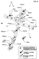
- Figure 3 shows the depiction of the series of positions 130(1), 130(2) . . . 130(n) of the single cellular phone from Figure 2.
- Figure 3 also shows a plurality of roads 152 that form a road network 155 in the geographic area 100.
- the road network 155 is represented by data 170 in a geographic database 172.
- a plurality of points 150 are shown located along the roads 152.
- the points 150 are positions along each of the roads 152.
- Each of the points 150 is associated with geographic coordinates that define the location of the point in the geographic area 100.
- the coordinates may be absolute or relative.
- the points 150 therefore define the locations of the roads 152 in the geographic area 100.
- Included among the data 170 are data 174 representing the coordinates of the points along the roads 152 that form the road network 155 represented by the geographic database 172.
- a data collection system 200 uses the data 140 collected by the cellular phone location determining system 104 in conjunction with the data 170 from the geographic database 172 to generate new data 210.
- the data collection system 200 matches the acquired cellular phone position data 140 to the locations of roads 152 represented by the data 170 in the geographic database 172.
- the new data 210 can be used for several purposes as described below.
- the data collection system 200 includes a process 250 that acquires the data 140 indicating the positions of cellular phones in a geographic area. Then, the data collection system 200 includes a process 256 that matches the acquired cellular phone positions 140 to positions of roads 152 which are represented by the data 170 in the geographic database 172.
- map matching techniques are used in navigation systems to match geographic coordinates obtained by GPS systems to geographic data contained in geographic databases that define road positions.
- the matching process 256 optionally includes other processes 260 that perform analysis and filtration of the data 140.
- the analysis and filtration processes 260 may make use of several assumptions and/or observations. For example, if the acquired cellular position data 140 indicate that the cellular phone is on or within a certain threshold distance of the position of a road 152 or is moving, the cellular phone can be assumed to be inside of a vehicle traveling along the road. This is illustrated in connection with Figure 5.
- straight dashed lines 266 are shown connecting the points 150 that are located along the actual roads (152 shown in Figure 3) and for which data (174 in Figure 4) are included in the geographic database to represent the positions of the roads.
- the straight dashed lines 266 in Figure 5 approximate the actual paths of the roads represented by the points 150.
- curved lines can be generated between the points 150 instead of straight lines.
- An appropriate curve fitting algorithm can be used.
- the analysis process 260 computes a distance 270 between each of the locations 130 of the phone and the straight dashed lines 266 which represent the roads. If the distances 270 are sufficiently small, the cellular phone can be assumed to be in a vehicle traveling along the actual road.
- Another operation that can be performed in the analysis and filtration step 260 is to determine a rate of travel of the cellular phone.
- the rate of travel can be used as a factor when determining whether the cellular phone is located in a vehicle traveling along the road.
- the cellular phone location determining system 104 can acquire a plurality of locations for a single phone over a period of time. Each of these positions is associated with a time. Using each position of the cellular phone relative to the previous (in time) position, a rate of travel of the cellular phone across the geographic area can be determined. A direction of travel can also be determined.
- a relatively high probability can be assigned that the cellular phone is located in a vehicle traveling along a road in the geographic area.
- the rate of travel of a cellular phone derived from the series of locations determined for the phone can be used in combination with other factors, such as the distances of the cellular phone locations from the centerline of the road, to determine a probability that the cellular phone is located in a vehicle traveling along the road.
- Another operation that can be performed in the analysis and filtration step 260 is to use the type or category of the road as a factor when determining whether the cellular phone is located in a vehicle traveling along the road. If the geographic data 170 includes data that indicates a type or class for roads represented by the database, the type or class can be used in the matching and filtering steps. For example, if the position of the cellular phone coincides with (or is within a threshold distance of) a road and the road is classified as an "expressway", then a relatively higher probability can be assigned to the determination that the cellular phone is in a vehicle traveling along the road.
- the determination that the cellular phone is in a vehicle traveling along the road has a relatively lower probability.
- the process 260 in the data collection system 200 can filter and analyze the acquired data 140 that represent phone positions. Alternatively, the analysis and filtration step 260 can be skipped.
- the data 210 representing the matched positions is output by the data collection system 200.
- These matched position data 210 may be used in various ways, as explained in more detail below.
- the phone locating system 104 determines the positions of a plurality of cellular phones 106(1), 106(2) . . . 106(n).
- the locations of a plurality of positions from a plurality of cellular phones can be handled in the same manner as described above with respect to a single phone.
- Figure 6 shows the plurality of positions 130(n)(1), 130(n)(1) . . .130(n)(n) determined for a first cellular phone 106(n), the positions 130(m)(1), 130(m)(1). . .130(m)(n) determined for another cellular phone 106(m), the positions 130(p)(1), 130(p)(1). . .130(p)(n) determined for still another cellular phone 106(p), and so on.
- hundreds, thousands, or millions of positions of hundreds, thousands, or millions of cellular phones may be acquired by the phone location determining system 104.
- the data collection system 200 acquires data indicating these positions.
- the data collection system 200 can employ analysis and filtration steps 260 with respect to the acquired data.
- the plurality of cellular phone positions 130 can cluster along lines extending between the points 150 that define the positions of roads in the geographic database.
- the distances of these cellular phone positions from the paths of the roads can be used to determine which of the positions is associated with a cellular phone located in a vehicle. Any cellular phone location that is substantially away from the road positions 150 (such as the cellular phone position labeled 300(R)) can be assumed to be operated by a user who is not traveling along a road. Data indicating cellular phone positions that are located away from the road paths can be filtered out.
- each of a plurality of cellular phones over time can also be collected, processed and analyzed using the processes described in connection with Figure 4.
- Each cellular phone whose positions are being monitored includes a unique signature or ID.
- the rates of travel of the plurality of cellular phones along each of the plurality of roads can be determined.
- the directions of travel for the pluralities of phones can also be determined.
- the matched data 210 output by the data collection system 200 can be used in various ways.
- the output of the data collection system 200 can be used for traffic monitoring and reporting. Steps included for this traffic monitoring and reporting application are shown in Figure 7.
- a density of the clusters along the roads can be determined (e.g., cellular phones per length of road). From the density, an estimate can be made of how much traffic is travelling along the road.
- a rate of travel can also be determined for the plurality of phones.
- a rate of travel can be determined by the series of positions of each of the cellular phones.
- average travel speeds along some or all the roads in a geographic area can be determined. This information can be used by traffic monitoring organizations.
- This traffic data can be broadcast (or otherwise reported) back to the users in the area.
- the data can be broadcast by radio or transmitted as telephone messages.
- the traffic can be sent in any type of traffic data format, such as the Radio Data System-Traffic Message Channel (“RDS-TMC”), and other data formats.
- RDS-TMC Radio Data System-Traffic Message Channel
- the data collection system 200 can determine which lanes of traffic on roads have the fastest rates of travel.
- the rates of travel of the cellular phones in each of the lanes can be determined.
- the rates of traffic in different lanes may differ significantly if an accident is blocking a lane.
- the location of an accident may be determined by detecting the location at which the rate of travel in a lane of traffic changes abruptly.
- a traffic message can be broadcast that informs vehicle drivers which lane(s) to avoid.
- a geographic database can be updated using data collected by a plurality of vehicles traveling an a geographic area.
- a geographic database can also be updated using the position data for a plurality of cellular telephones. Steps included for this application are shown in Figure 8.
- the positions of cellular phones can be used in a similar way as the positions of probe vehicles, as described in EP 0 921 509. For example, the positions of cellular phones traveling through a geographic region can be used to add data representing new roads to the database. If a large number of cellular phone positions indicate a travel path through a location in a geographic region, it can be determined that a road passes through the point.
- Data about traffic restrictions can also be derived. For example, if the cellular phones follow paths describing left turns from one road onto another except during the hours of 4:00pm to 6:00pm, data can be derived that a turn restriction exists at the intersection of these roads that prohibits left turns between these hours. Other data about the road network can be derived from the travel paths of cellular phones.
- the positions of cellular phones traveling through the geographic area can also be used to update the data that indicate the positions of roads that are already represented in the geographic database.
- Using the positions of cellular phones that travel along roads can help increase the accuracy of the data that represent the positions used to represent roads in the database. Even if the cellular phone location determining system does not have very high accuracy, relatively high accuracy can be obtained by the statistical analysis of a large number of data points representing cellular phone locations over time. Then, the database with new, more accurate data can be used for subsequent cellular phone location matching.
- the acquisition of location data for cellular phones can be used in a feedback loop process that continues to improve the accuracy of the geographic database.
- the geographic database with improved accuracy can be used to make derived database products.
- the derived database products may include only portions of all the data in the master version of the database.
- the derived database products may include data that relate to only one or more specific regions.
- the derived database products may be used on various kinds of computing platforms.
- the derived database products may be used in navigation systems (such as in-vehicle navigation systems and hand-held portable navigation systems), personal computers (including desktop and notebook computers), and other kinds of devices (such as PalmPilot®-type devices, pagers, telephones, personal digital assistants, and so on).
- Derived database products may also be used on networked computing platforms and environments, including the Internet.
- the derived database products can be used in various applications.
- the derived database products may be used in navigation-related applications such as applications provided in in-vehicle navigation systems.
- the navigation-related applications may include route calculation, route guidance, vehicle positioning, map display, and electronic yellow pages, as well as other kinds of functions.
- the derived database products may be in a different format than the format in which the master copy of the database is maintained.
- the derived database products may be in a format that facilitates the uses of the derived products in the platforms in which they are installed.
- the derived database products may also be stored in a compressed format on the media on which they are located.
- the geographic database with improved accuracy can be distributed to users of systems that have safety-related features such as obstacle avoidance, automatic cruise control, etc.
- the cellular phone locating system may be implemented using any technology which is available now or that becomes available in the future.
- the data collection system disclosed above is not limited to any particular wireless phone technology. Embodiments of the data collection systems, disclosed above, may be used with any kind of wireless phone whose position in a geographic area can be determined. Cellular, PCS, GSM, and other wireless technologies are all suitable.
- a phone does not have to be in use in order for the position of the phone to be determined.
- Some cellular phones may include their own hardware and software that provide for determining the geographic position of the cellular phone.
- some cellular phones may include GPS positioning systems.
- the disclosed data collection system could be used with these types of cellular phones.
- Embodiments of the present system may also be used with electronic devices other than telephones.
- Embodiments of the disclosed data collection system may be used with pagers, for example.
- the data collection system can include combinations of different remote devices, such as cellular phones and pagers, etc.
- data collected from cellular phones can be combined with data collected with in-vehicle navigation systems, as described in EP 0 921 509.
- the locations of roads in a geographic region were represented in the geographic database by data that included the geographic coordinates of points along the represented roads.
- locations of roads may be represented in a geographic database by other methods. Some other ways for representing locations of roads in a geographic database are described in copending application Ser. No. 08/979,21, filed November 16, 1997, the entire disclosure of which is incorporated by reference herein. If an embodiment of the data collection system uses a geographic database that uses a method to identify the locations of roads other than by the geographic coordinates of points along the represented roads, an appropriate map matching process would be used to match the positions determined for the cellular phones to the locations of the roads represented by the geographic database.
- the present system and method provide for collecting data geographic data efficiently and quickly. More particularly, the present system and method provide for collecting geographic data using an existing infrastructure that covers all roads.
Abstract
Description
- The present application is a continuation-in-part of Ser. No. 08/951,767, filed October 16, 1997, the entire disclosure of which is incorporated by reference herein.
- The present invention relates to collecting geographic data and more particularly, the present invention relates to a process and system that determines the positions of cellular phones, or other types of wireless phones, matches the positions of the cellular phones to positions of roads in a geographic area, and uses the results of the matching for updating or refining a geographic database, traffic monitoring, or for other purposes.
- Geographic databases have various uses. Geographic databases are used in in-vehicle navigation systems, personal computers, networked computing environments, and various other kinds of platforms, as well as on the Internet. Geographic databases are used with various kinds of applications to provide various functions including map display, route calculation, route guidance, truck fleet deployment, traffic control, traffic monitoring, electronic yellow pages, roadside assistance, emergency services, and so on.
- In order to provide these kinds of functions, a geographic database includes data that represent geographic features in a covered geographic region. Geographic databases include details about represented geographic features, such as the geographic coordinates of roads in a geographic region, speed limits along the road segments, locations of stop lights, turn restrictions at intersections of roads, address ranges, street names, and so on. Geographic databases may also include information about points of interest in covered regions. Points of interest may include restaurants, hotels, airports, gas stations, stadiums, police stations, and so on.
- Collecting information for a geographic database is a significant task. Not only is the initial collection of data a significant undertaking, but a geographic database needs to be updated on a regular basis. For example, new streets are constructed, street names change, traffic lights are installed, and turn restrictions are added to existing roads. Also, new levels of detail may be added about geographic features that are already represented in an existing geographic database. For example, an existing geographic database for roads may be enhanced with information about lane widths, shoulder sizes, lane barriers, address ranges, sidewalks, bicycles paths, etc. Thus, there exists a need to continue to collect information for a geographic database.
- One method for collecting data for a geographic database is described in European Patent Application No. EP 0 921 509. According to one embodiment described in EP 0 921 509, navigation systems installed in a plurality of vehicles are used as probes to collect geographic data as the vehicles are driven in a geographic region. These navigation systems may also provide navigation-related features to the drivers and/or passengers of the vehicles in which they are installed or alternatively the navigation systems may serve only to collect geographic data as the vehicles in which they are installed are driven. The geographic data collected by the plurality of vehicles are gathered together, analyzed, and used to update or refine a master geographic database. Copies of the master geographic database, or database products derived from the master copy, can then be distributed back to the plurality of vehicles and used in the navigation systems installed in the plurality of vehicles.
- The embodiments described in EP 0 921 509 can afford advantages. However, there is still room for improvement. Accordingly, there exists a need to provide an improved method and system for collecting data for a geographic database.
- There also exists a separate need to collect traffic information. Collection of traffic information is important for many purposes. For example, traffic information is used by commuters on a daily basis. Various methods have been used to collect traffic information. These methods have included direct observation, sensors embedded in the roads or located alongside roads, and other means. Although prior methods of collecting traffic information have been adequate, there exists room for improvement. For example, traffic information could be collected less expensively. Also, prior methods of traffic information collection have focused on only certain roads, typically the roads with the highest volumes of traffic. It would be beneficial to collect traffic information for more roads.
- To address these and other objectives, the present invention comprises a method and system that matches the positions of one or more cellular phones, or other types of wireless phones, to data indicating the locations of roads in a geographic area to derive data about phones located in vehicles traveling along the roads. The data about phones located in vehicles traveling along the roads are used for updating or refining a geographic database, traffic monitoring and/or reporting, or for other purposes.
-
- Figure 1 is an illustration of a cellular phone location determining system located in a geographic region, wherein the cellular phone location determining system is used as a component of a first embodiment of a data collection system.
- Figure 2 is a diagram illustrating a series of positions determined over a period of time for a single cellular telephone using the cellular telephone determining system shown in Figure 1.
- Figure 3 is a diagram illustrating the series of positions in Figure 2 overlaid on a map of a portion of the road network of Figure 1.
- Figure 4 is a block diagram showing components of the data collection system of Figure 1.
- Figure 5 shows the map of Figure 3 illustrating the map matching process performed by the data collection system of Figures 1 and 4.
- Figure 6 is an illustration of a plurality of positions determined for a plurality of cellular telephones wherein the positions are determined using the cellular telephone location determining system shown in Figures 1 and 4.
- Figure 7 is a flow chart showing a real-time traffic reporting system that uses the data collection system of Figure 4.
- Figure 8 is a flow chart showing a database updating system that uses the data collection system of Figure 4.
-
- Referring to Figure 1, there is an illustration of a
geographic area 100. Located in thegeographic area 100 is a cellular phone location determining system 104. The cellular phone location determining system 104 may includetowers 108 or other equipment located throughout thegeographic area 100. The cellular phone location determining system 104 may include appropriate hardware and software that are able to locate the positions ofcellular phones 106 in thegeographic area 100. There are various available technologies that can be used to determine the positions of cellular phones in an area. Some of these technologies are used to locate a cellular phone user who dials an emergency number, e.g., "911 ." Any such technology that is presently available or that becomes available in the future may be suitable for the phone location determining system 104 in Figure 1. - Referring to Figure 2, there is a depiction of a series of locations 130(1), 130(2). . . 130(n). The series of locations 130(1), 130(2) . . . 130(n) are located in the
geographic area 100 of Figure 1. The series of locations 130(1), 130(2) . . . 130(n) are positions determined for a singlecellular phone 106 over a period of time using the cellular phone location determining system 104 in Figure 1. The series of locations 130(1), 130(2) . . . 130(n) may represent the position of the cellular phone at regular intervals, irregular intervals, or other time periods. The locations may be determined as absolute positions or relative positions. In one embodiment, the cellular phone location determining system 104outputs data 140 identifying the phone, the position (e.g., geographic coordinates, relative coordinates, etc.), and a time stamp (e.g., the absolute or relative time at which the identified cellular phone was at the identified position). - Figure 3 shows the depiction of the series of positions 130(1), 130(2) . . . 130(n) of the single cellular phone from Figure 2. Figure 3 also shows a plurality of
roads 152 that form aroad network 155 in thegeographic area 100. Referring to Figures 3 and 4, theroad network 155 is represented bydata 170 in ageographic database 172. In Figure 3, a plurality ofpoints 150 are shown located along theroads 152. Thepoints 150 are positions along each of theroads 152. Each of thepoints 150 is associated with geographic coordinates that define the location of the point in thegeographic area 100. The coordinates may be absolute or relative. Thepoints 150 therefore define the locations of theroads 152 in thegeographic area 100. Included among thedata 170 aredata 174 representing the coordinates of the points along theroads 152 that form theroad network 155 represented by thegeographic database 172. - In Figure 4, a
data collection system 200 uses thedata 140 collected by the cellular phone location determining system 104 in conjunction with thedata 170 from thegeographic database 172 to generatenew data 210. Thedata collection system 200 matches the acquired cellularphone position data 140 to the locations ofroads 152 represented by thedata 170 in thegeographic database 172. Thenew data 210 can be used for several purposes as described below. - Referring to Figure 4, the
data collection system 200 includes aprocess 250 that acquires thedata 140 indicating the positions of cellular phones in a geographic area. Then, thedata collection system 200 includes aprocess 256 that matches the acquiredcellular phone positions 140 to positions ofroads 152 which are represented by thedata 170 in thegeographic database 172. Various techniques for map matching can be used. For example, map matching techniques are used in navigation systems to match geographic coordinates obtained by GPS systems to geographic data contained in geographic databases that define road positions. - The
matching process 256 optionally includesother processes 260 that perform analysis and filtration of thedata 140. The analysis andfiltration processes 260 may make use of several assumptions and/or observations. For example, if the acquiredcellular position data 140 indicate that the cellular phone is on or within a certain threshold distance of the position of aroad 152 or is moving, the cellular phone can be assumed to be inside of a vehicle traveling along the road. This is illustrated in connection with Figure 5. In Figure 5, straight dashedlines 266 are shown connecting thepoints 150 that are located along the actual roads (152 shown in Figure 3) and for which data (174 in Figure 4) are included in the geographic database to represent the positions of the roads. The straight dashedlines 266 in Figure 5 approximate the actual paths of the roads represented by thepoints 150. (In an alternative embodiment, curved lines can be generated between thepoints 150 instead of straight lines. An appropriate curve fitting algorithm can be used.) Theanalysis process 260 computes adistance 270 between each of thelocations 130 of the phone and the straight dashedlines 266 which represent the roads. If thedistances 270 are sufficiently small, the cellular phone can be assumed to be in a vehicle traveling along the actual road. - Another operation that can be performed in the analysis and
filtration step 260 is to determine a rate of travel of the cellular phone. The rate of travel can be used as a factor when determining whether the cellular phone is located in a vehicle traveling along the road. As mentioned above, the cellular phone location determining system 104 can acquire a plurality of locations for a single phone over a period of time. Each of these positions is associated with a time. Using each position of the cellular phone relative to the previous (in time) position, a rate of travel of the cellular phone across the geographic area can be determined. A direction of travel can also be determined. If the rate of travel is greater than a threshold, e.g., 5 miles per hour, a relatively high probability can be assigned that the cellular phone is located in a vehicle traveling along a road in the geographic area. The rate of travel of a cellular phone derived from the series of locations determined for the phone can be used in combination with other factors, such as the distances of the cellular phone locations from the centerline of the road, to determine a probability that the cellular phone is located in a vehicle traveling along the road. - Another operation that can be performed in the analysis and
filtration step 260 is to use the type or category of the road as a factor when determining whether the cellular phone is located in a vehicle traveling along the road. If thegeographic data 170 includes data that indicates a type or class for roads represented by the database, the type or class can be used in the matching and filtering steps. For example, if the position of the cellular phone coincides with (or is within a threshold distance of) a road and the road is classified as an "expressway", then a relatively higher probability can be assigned to the determination that the cellular phone is in a vehicle traveling along the road. On the other hand, if the position of the cellular phone coincides with (or is within a threshold distance of) a road and the road is classified as an "alley", then the determination that the cellular phone is in a vehicle traveling along the road has a relatively lower probability. - Using some or all of the factors described above, the
process 260 in thedata collection system 200 can filter and analyze the acquireddata 140 that represent phone positions. Alternatively, the analysis andfiltration step 260 can be skipped. - Following the analysis and
filtration step 260, if performed, thedata 210 representing the matched positions is output by thedata collection system 200. These matchedposition data 210 may be used in various ways, as explained in more detail below. - The process described above whereby positions of a cellular phone can be used to obtain matched position data can be used with the positions of a plurality of cellular phones. As explained above in connection with Figure 1, the phone locating system 104 determines the positions of a plurality of cellular phones 106(1), 106(2) . . . 106(n). The locations of a plurality of positions from a plurality of cellular phones can be handled in the same manner as described above with respect to a single phone.
- Figure 6 shows the plurality of positions 130(n)(1), 130(n)(1) . . .130(n)(n) determined for a first cellular phone 106(n), the positions 130(m)(1), 130(m)(1). . .130(m)(n) determined for another cellular phone 106(m), the positions 130(p)(1), 130(p)(1). . .130(p)(n) determined for still another cellular phone 106(p), and so on. In this embodiment, hundreds, thousands, or millions of positions of hundreds, thousands, or millions of cellular phones may be acquired by the phone location determining system 104.
- As described above in connection with Figure 4, the
data collection system 200 acquires data indicating these positions. Thedata collection system 200 can employ analysis andfiltration steps 260 with respect to the acquired data. For example, as shown by Figure 6, the plurality ofcellular phone positions 130 can cluster along lines extending between thepoints 150 that define the positions of roads in the geographic database. As described above, the distances of these cellular phone positions from the paths of the roads can be used to determine which of the positions is associated with a cellular phone located in a vehicle. Any cellular phone location that is substantially away from the road positions 150 (such as the cellular phone position labeled 300(R)) can be assumed to be operated by a user who is not traveling along a road. Data indicating cellular phone positions that are located away from the road paths can be filtered out. - The locations of each of a plurality of cellular phones over time can also be collected, processed and analyzed using the processes described in connection with Figure 4. Each cellular phone whose positions are being monitored includes a unique signature or ID. Thus, the rates of travel of the plurality of cellular phones along each of the plurality of roads can be determined. The directions of travel for the pluralities of phones can also be determined.
- The matched
data 210 output by thedata collection system 200 can be used in various ways. - In one embodiment, the output of the
data collection system 200 can be used for traffic monitoring and reporting. Steps included for this traffic monitoring and reporting application are shown in Figure 7. Using the matched phone location data for a plurality of cellular phones (such as shown in Figure 6), a density of the clusters along the roads can be determined (e.g., cellular phones per length of road). From the density, an estimate can be made of how much traffic is travelling along the road. A rate of travel can also be determined for the plurality of phones. A rate of travel can be determined by the series of positions of each of the cellular phones. Thus, using the matched data of a plurality of cellular phones, average travel speeds along some or all the roads in a geographic area can be determined. This information can be used by traffic monitoring organizations. This traffic data can be broadcast (or otherwise reported) back to the users in the area. The data can be broadcast by radio or transmitted as telephone messages. Alternatively, the traffic can be sent in any type of traffic data format, such as the Radio Data System-Traffic Message Channel ("RDS-TMC"), and other data formats. - In a further embodiment, the
data collection system 200 can determine which lanes of traffic on roads have the fastest rates of travel. When thedata collection system 200 is used with a multi-lane road, the rates of travel of the cellular phones in each of the lanes can be determined. The rates of traffic in different lanes may differ significantly if an accident is blocking a lane. The location of an accident may be determined by detecting the location at which the rate of travel in a lane of traffic changes abruptly. When the data collection system detects a significant difference in the rates of travel in different lanes, a traffic message can be broadcast that informs vehicle drivers which lane(s) to avoid. - Another application for the matched data obtained by the data collection system described above is the updating and refinement of a geographic database. As described in EP 0 921 509, a geographic database can be updated using data collected by a plurality of vehicles traveling an a geographic area. A geographic database can also be updated using the position data for a plurality of cellular telephones. Steps included for this application are shown in Figure 8. According to this embodiment, the positions of cellular phones can be used in a similar way as the positions of probe vehicles, as described in EP 0 921 509. For example, the positions of cellular phones traveling through a geographic region can be used to add data representing new roads to the database. If a large number of cellular phone positions indicate a travel path through a location in a geographic region, it can be determined that a road passes through the point.
- Data about traffic restrictions can also be derived. For example, if the cellular phones follow paths describing left turns from one road onto another except during the hours of 4:00pm to 6:00pm, data can be derived that a turn restriction exists at the intersection of these roads that prohibits left turns between these hours. Other data about the road network can be derived from the travel paths of cellular phones.
- The positions of cellular phones traveling through the geographic area can also be used to update the data that indicate the positions of roads that are already represented in the geographic database. Using the positions of cellular phones that travel along roads can help increase the accuracy of the data that represent the positions used to represent roads in the database. Even if the cellular phone location determining system does not have very high accuracy, relatively high accuracy can be obtained by the statistical analysis of a large number of data points representing cellular phone locations over time. Then, the database with new, more accurate data can be used for subsequent cellular phone location matching. Thus, the acquisition of location data for cellular phones can be used in a feedback loop process that continues to improve the accuracy of the geographic database.
- The geographic database with improved accuracy can be used to make derived database products. The derived database products may include only portions of all the data in the master version of the database. For example, the derived database products may include data that relate to only one or more specific regions.
- The derived database products may be used on various kinds of computing platforms. For example, the derived database products may be used in navigation systems (such as in-vehicle navigation systems and hand-held portable navigation systems), personal computers (including desktop and notebook computers), and other kinds of devices (such as PalmPilot®-type devices, pagers, telephones, personal digital assistants, and so on). Derived database products may also be used on networked computing platforms and environments, including the Internet.
- The derived database products can be used in various applications. For example, the derived database products may be used in navigation-related applications such as applications provided in in-vehicle navigation systems. The navigation-related applications may include route calculation, route guidance, vehicle positioning, map display, and electronic yellow pages, as well as other kinds of functions.
- The derived database products may be in a different format than the format in which the master copy of the database is maintained. The derived database products may be in a format that facilitates the uses of the derived products in the platforms in which they are installed. The derived database products may also be stored in a compressed format on the media on which they are located.
- The geographic database with improved accuracy can be distributed to users of systems that have safety-related features such as obstacle avoidance, automatic cruise control, etc.
- As mentioned above, the cellular phone locating system may be implemented using any technology which is available now or that becomes available in the future.
- The data collection system disclosed above is not limited to any particular wireless phone technology. Embodiments of the data collection systems, disclosed above, may be used with any kind of wireless phone whose position in a geographic area can be determined. Cellular, PCS, GSM, and other wireless technologies are all suitable.
- With some embodiments of the cellular phone locating system, a phone does not have to be in use in order for the position of the phone to be determined.
- Some cellular phones may include their own hardware and software that provide for determining the geographic position of the cellular phone. For example, some cellular phones may include GPS positioning systems. The disclosed data collection system could be used with these types of cellular phones.
- Embodiments of the present system may also be used with electronic devices other than telephones. Embodiments of the disclosed data collection system may be used with pagers, for example.
- In other alternative embodiments, the data collection system can include combinations of different remote devices, such as cellular phones and pagers, etc. In still another alternative embodiment of a data collection system, data collected from cellular phones can be combined with data collected with in-vehicle navigation systems, as described in EP 0 921 509.
- In one of the embodiments described above, the locations of roads in a geographic region were represented in the geographic database by data that included the geographic coordinates of points along the represented roads. In alternative embodiments, locations of roads may be represented in a geographic database by other methods. Some other ways for representing locations of roads in a geographic database are described in copending application Ser. No. 08/979,21, filed November 16, 1997, the entire disclosure of which is incorporated by reference herein. If an embodiment of the data collection system uses a geographic database that uses a method to identify the locations of roads other than by the geographic coordinates of points along the represented roads, an appropriate map matching process would be used to match the positions determined for the cellular phones to the locations of the roads represented by the geographic database.
- The present system and method provide for collecting data geographic data efficiently and quickly. More particularly, the present system and method provide for collecting geographic data using an existing infrastructure that covers all roads.
- It is intended that the foregoing detailed description be regarded as illustrative rather than limiting and that it is understood that the following claims including all equivalents are intended to define the scope of the invention.
Claims (22)
- A method of collecting data for a geographic database comprising the steps of:determining positions of a plurality of cellular phones in a geographic area using a cellular phone location determining system; andmatching the positions of said plurality of cellular phones to positions of roads represented by data in a geographic database.
- The method of Claim 1 further comprising:determining rates of vehicular travel along said roads using said positions of said plurality of cellular phones.
- The method of Claim 2 further comprising:reporting said rates of vehicular travel to users of vehicles in said geographic area.
- The method of Claim 1 further comprising:determining traffic densities along said roads using said positions of said plurality of cellular phones.
- The method of Claim 4 further comprising:reporting said traffic densities to users of vehicles in said geographic area.
- The method of Claim 1 further comprising:determining a direction of travel of said plurality of cellular phones along a road.
- The method of Claim 1 further comprising:using said matched positions of said plurality of cellular phones to update the data representing roads in said geographic database.
- The method of Claim 7 further comprising:distributing said geographic database with said updated data to users of navigation systems in said geographic area.
- The method of Claim 7 further comprising:collecting positions along roads of a plurality of vehicles using data collected by in-vehicle navigation systems installed in said vehicles; andusing said positions along roads of said plurality of vehicles in combination with said matched positions of said plurality of cellular phones to update the data representing roads in said geographic database.
- The method of Claim 7 wherein said updating step comprises:adding data representing turn restrictions along roads.
- The method of Claim 7 wherein said updating step comprises:adding data representing turn restrictions at specific times of day along roads.
- The method of Claim 1 wherein said cellular phone location determining system also determines positions of PCS phones.
- The method of Claim 1 further comprising the step of:discarding positions of cellular phones that are greater than a threshold distance away from a road.
- The method of Claim 1 further comprising the step of:using a road category as a factor when matching said positions of said plurality of cellular phones to positions of roads represented by data in said geographic database to determine on which of said roads each of said cellular phones is located.
- The method of Claim 1 further comprising:for each lane of a multi-lane road, determining a rate of vehicular travel using positions of cellular phones; andwhen the rate of vehicular travel in one lane of the multi-lane road differs by a significant amount from a rate of vehicular travel in another lane of the multi-lane road, advising users of vehicles about which lane to avoid.
- A method of collecting data for a geographic database comprising the steps of:for each cellular phone of a plurality of cellular phones, determining a series of positions of said cellular phone in a geographic area over time using a cellular phone location determining system; andmatching the series of positions of each cellular phone of said plurality of cellular phones to positions of roads represented by data in a geographic database to determine which of said roads each of said cellular phones is traveling along.
- The method of Claim 16 further comprising the step of:using the series of positions of each of said plurality of cellular phones to refine the data in said geographic database that represent said roads.
- The method of Claim 16 further comprising the step of:statistically analyzing the series of positions of each of said plurality of cellular phones to determine locations of roads along which said plurality of cellular phones travel; andrefining the data in said geographic database with the locations of roads determined by the statistical analysis of the positions of said plurality of cellular phones.
- A method of collecting data for a geographic database comprising the steps of:determining a position of a single of cellular phone in a geographic area using a cellular phone location determining system; andmatching the position of said cellular phone to positions of roads represented by data in a geographic database to determine on which of said roads said cellular phone is located.
- The method of Claim 19 further comprising:determining a plurality of positions of said single cellular phone in said geographic area using said cellular phone location determining system; andmatching said plurality of positions of said single cellular phone to positions of roads represented by data in said geographic database to determine on which of said roads said cellular phone is located.
- The method of Claim 20 further comprising:determining a rate of travel of said cellular phone along a road.
- The method of Claim 20 further comprising:determining a direction of travel of said cellular phone along a road.
Applications Claiming Priority (2)
| Application Number | Priority Date | Filing Date | Title |
|---|---|---|---|
| US09/379,133 US6381533B1 (en) | 1997-10-16 | 1999-08-20 | Method and system using positions of cellular phones matched to road network for collecting data |
| US379133 | 1999-08-20 |
Publications (2)
| Publication Number | Publication Date |
|---|---|
| EP1081666A2 true EP1081666A2 (en) | 2001-03-07 |
| EP1081666A3 EP1081666A3 (en) | 2001-06-13 |
Family
ID=23495954
Family Applications (1)
| Application Number | Title | Priority Date | Filing Date |
|---|---|---|---|
| EP00301918A Withdrawn EP1081666A3 (en) | 1999-08-20 | 2000-03-08 | Method and system using positions of cellular phones matched to road network for collecting data |
Country Status (3)
| Country | Link |
|---|---|
| US (1) | US6381533B1 (en) |
| EP (1) | EP1081666A3 (en) |
| JP (1) | JP4733251B2 (en) |
Cited By (11)
| Publication number | Priority date | Publication date | Assignee | Title |
|---|---|---|---|---|
| GB2369966A (en) * | 2000-12-06 | 2002-06-12 | Roke Manor Research | Location-dependent data collection |
| WO2003034371A1 (en) * | 2001-10-10 | 2003-04-24 | Vodafone Holding Gmbh | Method and system for determining displacement time of a mobile user terminal equipment |
| WO2003088584A1 (en) * | 2002-04-05 | 2003-10-23 | Lennart Isaksson | A system operable to manage and provide results-, prognosis- and games & gaming information for geographically distributed sports |
| EP1376058A2 (en) | 2002-06-27 | 2004-01-02 | Navigation Technologies Corporation | Method of collecting market research information |
| US7092964B1 (en) | 2001-06-22 | 2006-08-15 | Navteq North America, Llc | Method of collecting market research information |
| US7206585B2 (en) | 2000-12-06 | 2007-04-17 | Roke Manor Research Ltd. | Location-dependent data collection |
| DE102004042302B4 (en) * | 2003-08-28 | 2010-01-21 | Österreichisches Forschungs- und Prüfzentrum Arsenal Ges. m.b.H. | Method and arrangement for determining ways of road users |
| EP2416290A1 (en) * | 2009-04-01 | 2012-02-08 | NTT DoCoMo, Inc. | Position information analysis device and position information analysis method |
| CN104050805A (en) * | 2013-03-12 | 2014-09-17 | 福特全球技术公司 | Method and apparatus for crowd-sourced traffic reporting |
| US9336679B1 (en) * | 2014-12-17 | 2016-05-10 | Ariba, Inc. | Measuring traffic condition based on mobile devices connection information |
| EP2468017A4 (en) * | 2009-08-21 | 2016-08-24 | Samsung Electronics Co Ltd | Method and apparatus for generating, managing, and sharing moving path |
Families Citing this family (74)
| Publication number | Priority date | Publication date | Assignee | Title |
|---|---|---|---|---|
| JP4599649B2 (en) * | 2000-03-09 | 2010-12-15 | 株式会社エクォス・リサーチ | Billing processing apparatus in data communication network |
| DE10041099C2 (en) * | 2000-08-22 | 2002-10-24 | Bosch Gmbh Robert | Method for the transmission of data packets between motor vehicles |
| US6560532B2 (en) * | 2001-05-25 | 2003-05-06 | Regents Of The University Of California, The | Method and system for electronically determining dynamic traffic information |
| DK1402457T3 (en) * | 2001-06-22 | 2011-05-02 | Caliper Corp | Traffic data management and simulation system |
| US7333820B2 (en) * | 2001-07-17 | 2008-02-19 | Networks In Motion, Inc. | System and method for providing routing, mapping, and relative position information to users of a communication network |
| CA2460136C (en) * | 2001-09-13 | 2011-06-14 | Airsage, Inc. | System and method for providing traffic information using operational data of a wireless network |
| US20030096621A1 (en) * | 2001-11-19 | 2003-05-22 | Rittwik Jana | Method and apparatus for identifying a group of users of a wireless service |
| US7720458B2 (en) * | 2002-05-30 | 2010-05-18 | Lockheed Martin Corporation | Rapidly deployable emergency communications system and method |
| JP2004013801A (en) * | 2002-06-11 | 2004-01-15 | Hitachi Electronics Service Co Ltd | Automatic reporting management system on arriving at destination and passage point |
| US6810321B1 (en) | 2003-03-17 | 2004-10-26 | Sprint Communications Company L.P. | Vehicle traffic monitoring using cellular telephone location and velocity data |
| US7415243B2 (en) | 2003-03-27 | 2008-08-19 | Honda Giken Kogyo Kabushiki Kaisha | System, method and computer program product for receiving data from a satellite radio network |
| US6965325B2 (en) * | 2003-05-19 | 2005-11-15 | Sap Aktiengesellschaft | Traffic monitoring system |
| KR100572666B1 (en) * | 2003-07-14 | 2006-04-24 | 에스케이 텔레콤주식회사 | Method for obtaining traffic information by using call data record of mobile |
| US7138914B2 (en) * | 2003-08-01 | 2006-11-21 | Spectrum Tracking Systems, Inc. | Method and system for providing tracking services to locate an asset |
| US8041779B2 (en) | 2003-12-15 | 2011-10-18 | Honda Motor Co., Ltd. | Method and system for facilitating the exchange of information between a vehicle and a remote location |
| US7818380B2 (en) * | 2003-12-15 | 2010-10-19 | Honda Motor Co., Ltd. | Method and system for broadcasting safety messages to a vehicle |
| WO2005099379A2 (en) * | 2004-04-06 | 2005-10-27 | Honda Motor Co., Ltd. | Method and system for controlling the exchange of vehicle related messages |
| US7680596B2 (en) | 2004-04-06 | 2010-03-16 | Honda Motor Co., Ltd. | Route calculation method for a vehicle navigation system |
| US7680594B2 (en) | 2004-04-06 | 2010-03-16 | Honda Motor Co., Ltd. | Display method and system for a vehicle navigation system |
| JP2005301581A (en) * | 2004-04-09 | 2005-10-27 | Denso Corp | Inter-vehicle communication system, inter-vehicle communication equipment and controller |
| US7518530B2 (en) * | 2004-07-19 | 2009-04-14 | Honda Motor Co., Ltd. | Method and system for broadcasting audio and visual display messages to a vehicle |
| US7643788B2 (en) * | 2004-09-22 | 2010-01-05 | Honda Motor Co., Ltd. | Method and system for broadcasting data messages to a vehicle |
| US8370054B2 (en) * | 2005-03-24 | 2013-02-05 | Google Inc. | User location driven identification of service vehicles |
| US7562049B2 (en) * | 2005-03-29 | 2009-07-14 | Honda Motor Co., Ltd. | Payment system and method for data broadcasted from a remote location to vehicles |
| US20060247844A1 (en) * | 2005-04-27 | 2006-11-02 | Irving Wang | Intelligent traffic monitoring and guidance system |
| US7949330B2 (en) * | 2005-08-25 | 2011-05-24 | Honda Motor Co., Ltd. | System and method for providing weather warnings and alerts |
| US8046162B2 (en) * | 2005-11-04 | 2011-10-25 | Honda Motor Co., Ltd. | Data broadcast method for traffic information |
| US20070124306A1 (en) * | 2005-11-09 | 2007-05-31 | Honda Motor Co., Ltd. | Method and system for transmitting data to vehicles over limited data links |
| US7469827B2 (en) | 2005-11-17 | 2008-12-30 | Google Inc. | Vehicle information systems and methods |
| US8014936B2 (en) * | 2006-03-03 | 2011-09-06 | Inrix, Inc. | Filtering road traffic condition data obtained from mobile data sources |
| US20070271034A1 (en) * | 2006-05-17 | 2007-11-22 | Perry Patrick E | Adaptive route planning for gps-based navigation |
| US20080215237A1 (en) * | 2006-05-17 | 2008-09-04 | International Business Machines Corporation | Design structure for adaptive route planning for gps-based navigation |
| US8793066B2 (en) | 2006-06-27 | 2014-07-29 | Microsoft Corporation | Route monetization |
| US7610151B2 (en) * | 2006-06-27 | 2009-10-27 | Microsoft Corporation | Collaborative route planning for generating personalized and context-sensitive routing recommendations |
| US7706964B2 (en) * | 2006-06-30 | 2010-04-27 | Microsoft Corporation | Inferring road speeds for context-sensitive routing |
| JP4910510B2 (en) * | 2006-06-30 | 2012-04-04 | 株式会社デンソー | Control information storage device and program |
| US7739040B2 (en) | 2006-06-30 | 2010-06-15 | Microsoft Corporation | Computation of travel routes, durations, and plans over multiple contexts |
| US7617042B2 (en) | 2006-06-30 | 2009-11-10 | Microsoft Corporation | Computing and harnessing inferences about the timing, duration, and nature of motion and cessation of motion with applications to mobile computing and communications |
| US8126641B2 (en) * | 2006-06-30 | 2012-02-28 | Microsoft Corporation | Route planning with contingencies |
| US8131205B2 (en) * | 2008-05-01 | 2012-03-06 | Michael Rosen | Mobile phone detection and interruption system and method |
| US8384555B2 (en) * | 2006-08-11 | 2013-02-26 | Michael Rosen | Method and system for automated detection of mobile phone usage |
| US7646312B2 (en) * | 2006-08-11 | 2010-01-12 | Michael Rosen | Method and system for automated detection of mobile telephone usage by drivers of vehicles |
| JP4569837B2 (en) * | 2007-03-30 | 2010-10-27 | アイシン・エィ・ダブリュ株式会社 | Feature information collecting apparatus and feature information collecting method |
| JP4437556B2 (en) * | 2007-03-30 | 2010-03-24 | アイシン・エィ・ダブリュ株式会社 | Feature information collecting apparatus and feature information collecting method |
| US7668653B2 (en) | 2007-05-31 | 2010-02-23 | Honda Motor Co., Ltd. | System and method for selectively filtering and providing event program information |
| US9043138B2 (en) * | 2007-09-07 | 2015-05-26 | Green Driver, Inc. | System and method for automated updating of map information |
| US20130131980A1 (en) * | 2007-09-07 | 2013-05-23 | On Time Systems, Inc. | Resolving gps ambiguity in electronic maps |
| US10083607B2 (en) | 2007-09-07 | 2018-09-25 | Green Driver, Inc. | Driver safety enhancement using intelligent traffic signals and GPS |
| US9852624B2 (en) | 2007-09-07 | 2017-12-26 | Connected Signals, Inc. | Network security system with application for driver safety system |
| JP2009075647A (en) * | 2007-09-18 | 2009-04-09 | Aisin Aw Co Ltd | Statistical processing server, probe information statistical method, and probe information statistical program |
| US8099308B2 (en) | 2007-10-02 | 2012-01-17 | Honda Motor Co., Ltd. | Method and system for vehicle service appointments based on diagnostic trouble codes |
| US20090106036A1 (en) * | 2007-10-22 | 2009-04-23 | Kazuya Tamura | Method and system for making automated appointments |
| US20090157540A1 (en) * | 2007-12-14 | 2009-06-18 | Microsoft Corporation | Destination auctioned through business of interest |
| US20090157498A1 (en) * | 2007-12-14 | 2009-06-18 | Microsoft Corporation | Generational intelligent navigation synchronization or update |
| US20090210242A1 (en) * | 2008-02-19 | 2009-08-20 | Microsoft Corporation | Load balance payment |
| US20090210302A1 (en) * | 2008-02-19 | 2009-08-20 | Microsoft Corporation | Route reward augmentation |
| US20090210142A1 (en) * | 2008-02-19 | 2009-08-20 | Microsoft Corporation | Safe route configuration |
| US8718928B2 (en) * | 2008-04-23 | 2014-05-06 | Verizon Patent And Licensing Inc. | Traffic monitoring systems and methods |
| BRPI0822748A2 (en) * | 2008-10-08 | 2015-06-23 | Tomtom Int Bv | Improvements Relating to Vehicle Navigation Device |
| US8064925B1 (en) | 2008-10-08 | 2011-11-22 | Sprint Spectrum L.P. | Method and system for determining vehicle traffic characteristics from wireless network registrations |
| US8135804B2 (en) * | 2009-07-07 | 2012-03-13 | Honda Motor Co., Ltd. | Method for scheduling and rescheduling vehicle service appointments |
| US10198942B2 (en) | 2009-08-11 | 2019-02-05 | Connected Signals, Inc. | Traffic routing display system with multiple signal lookahead |
| WO2011023244A1 (en) * | 2009-08-25 | 2011-03-03 | Tele Atlas B.V. | Method and system of processing data gathered using a range sensor |
| JP5059170B2 (en) * | 2010-06-25 | 2012-10-24 | 三菱電機株式会社 | Mobile terminal device and map data management method |
| US8452771B2 (en) | 2011-01-03 | 2013-05-28 | Honda Motor Co., Ltd. | Method for differentiating traffic data obtained from probe vehicles |
| US10319222B2 (en) | 2011-04-20 | 2019-06-11 | Nec Corporation | Traffic condition monitoring system, method, and storage medium |
| JP5896198B2 (en) * | 2011-05-31 | 2016-03-30 | 日本電気株式会社 | Traffic information generation system, traffic information generation method and program |
| US8981925B2 (en) | 2013-03-11 | 2015-03-17 | 3M Innovative Properties Company | System, method, and apparatus for detecting wireless devices |
| US9964414B2 (en) | 2013-03-15 | 2018-05-08 | Caliper Corporation | Lane-level vehicle navigation for vehicle routing and traffic management |
| KR102107123B1 (en) * | 2014-01-28 | 2020-05-06 | 현대엠엔소프트 주식회사 | The apparatus and method for automatic update navigation |
| JP6427908B2 (en) | 2014-03-24 | 2018-11-28 | アイシン・エィ・ダブリュ株式会社 | Map information generation system, method and program |
| US9754485B2 (en) * | 2015-06-16 | 2017-09-05 | DataSpark, PTE. LTD. | Traffic prediction and real time analysis system |
| US9882674B1 (en) | 2017-07-02 | 2018-01-30 | Fidelity Engineering Group, Inc. | System, method, and apparatus for detecting and jamming wireless devices |
| US11622314B2 (en) | 2019-12-30 | 2023-04-04 | Detection Innovation Group, Inc. | System, method, and apparatus for detecting and preventing wireless connections |
Citations (6)
| Publication number | Priority date | Publication date | Assignee | Title |
|---|---|---|---|---|
| US5182555A (en) * | 1990-07-26 | 1993-01-26 | Farradyne Systems, Inc. | Cell messaging process for an in-vehicle traffic congestion information system |
| WO1996001531A2 (en) * | 1994-03-09 | 1996-01-18 | Karbasi, Amir, Kiumars | Cellular positioning system (cps) |
| DE19525291C1 (en) * | 1995-07-03 | 1996-12-19 | Mannesmann Ag | Method and device for updating digital road maps |
| WO1996042179A1 (en) * | 1995-06-10 | 1996-12-27 | Phonelink Plc | Increasing the resolution in locating cellular telephones |
| US5696503A (en) * | 1993-07-23 | 1997-12-09 | Condition Monitoring Systems, Inc. | Wide area traffic surveillance using a multisensor tracking system |
| EP0921509A2 (en) * | 1997-10-16 | 1999-06-09 | Navigation Technologies Corporation | System and method for updating, enhancing or refining a geographic database using feedback |
Family Cites Families (21)
| Publication number | Priority date | Publication date | Assignee | Title |
|---|---|---|---|---|
| DE3700552B4 (en) | 1987-01-10 | 2005-06-02 | Robert Bosch Gmbh | Method for outputting route information for land vehicle drivers and information output system |
| JPH07117420B2 (en) | 1988-06-27 | 1995-12-18 | パイオニア株式会社 | Road data generation method in vehicle-mounted navigation device |
| US5243528A (en) | 1990-09-12 | 1993-09-07 | Motorola, Inc. | Land vehicle navigation apparatus with visual display |
| JP3133770B2 (en) | 1991-01-18 | 2001-02-13 | マツダ株式会社 | Car driving system |
| CA2061090A1 (en) * | 1991-03-11 | 1992-09-12 | Richard A. Miska | Personal mobile communication system with call bridging |
| US5983108A (en) * | 1992-01-27 | 1999-11-09 | Highwaymaster Communications, Inc. | Method and apparatus for a nation-wide cellular telephone network |
| US6144916A (en) | 1992-05-15 | 2000-11-07 | Micron Communications, Inc. | Itinerary monitoring system for storing a plurality of itinerary data points |
| US5543789A (en) * | 1994-06-24 | 1996-08-06 | Shields Enterprises, Inc. | Computerized navigation system |
| JP3653121B2 (en) * | 1995-04-19 | 2005-05-25 | 株式会社ザナヴィ・インフォマティクス | In-vehicle route search device and recommended route display method |
| US5731978A (en) | 1995-06-07 | 1998-03-24 | Zexel Corporation | Method and apparatus for enhancing vehicle navigation through recognition of geographical region types |
| EP0767358B1 (en) * | 1995-10-04 | 2004-02-04 | Aisin Aw Co., Ltd. | Vehicle navigation system |
| US5933100A (en) | 1995-12-27 | 1999-08-03 | Mitsubishi Electric Information Technology Center America, Inc. | Automobile navigation system with dynamic traffic data |
| JP3557776B2 (en) * | 1996-03-08 | 2004-08-25 | 日産自動車株式会社 | Route guidance device for vehicles |
| JP3252721B2 (en) * | 1996-10-07 | 2002-02-04 | カシオ計算機株式会社 | Behavior analysis device |
| US6011515A (en) | 1996-10-08 | 2000-01-04 | The Johns Hopkins University | System for measuring average speed and traffic volume on a roadway |
| US5828585A (en) | 1997-01-17 | 1998-10-27 | Delco Electronics Corporation | Vehicle speed signal calibration |
| AU7703598A (en) | 1997-05-30 | 1998-12-30 | David S. Booth | Generation and delivery of travel-related, location-sensitive information |
| US6140956A (en) | 1997-06-25 | 2000-10-31 | Cellutrac, Inc. | Vehicle tracking and security system incorporating simultaneous voice and data communication |
| JPH11133135A (en) * | 1997-10-28 | 1999-05-21 | Sony Corp | Gps receiver, gps administration office, and position information system |
| JPH11183184A (en) * | 1997-12-17 | 1999-07-09 | Xanavi Informatics Corp | Traffic information system |
| US6150961A (en) | 1998-11-24 | 2000-11-21 | International Business Machines Corporation | Automated traffic mapping |
-
1999
- 1999-08-20 US US09/379,133 patent/US6381533B1/en not_active Expired - Lifetime
-
2000
- 2000-03-08 EP EP00301918A patent/EP1081666A3/en not_active Withdrawn
- 2000-08-17 JP JP2000247173A patent/JP4733251B2/en not_active Expired - Lifetime
Patent Citations (6)
| Publication number | Priority date | Publication date | Assignee | Title |
|---|---|---|---|---|
| US5182555A (en) * | 1990-07-26 | 1993-01-26 | Farradyne Systems, Inc. | Cell messaging process for an in-vehicle traffic congestion information system |
| US5696503A (en) * | 1993-07-23 | 1997-12-09 | Condition Monitoring Systems, Inc. | Wide area traffic surveillance using a multisensor tracking system |
| WO1996001531A2 (en) * | 1994-03-09 | 1996-01-18 | Karbasi, Amir, Kiumars | Cellular positioning system (cps) |
| WO1996042179A1 (en) * | 1995-06-10 | 1996-12-27 | Phonelink Plc | Increasing the resolution in locating cellular telephones |
| DE19525291C1 (en) * | 1995-07-03 | 1996-12-19 | Mannesmann Ag | Method and device for updating digital road maps |
| EP0921509A2 (en) * | 1997-10-16 | 1999-06-09 | Navigation Technologies Corporation | System and method for updating, enhancing or refining a geographic database using feedback |
Cited By (15)
| Publication number | Priority date | Publication date | Assignee | Title |
|---|---|---|---|---|
| GB2369966B (en) * | 2000-12-06 | 2003-03-05 | Roke Manor Research | Location dependent data collection |
| GB2369966A (en) * | 2000-12-06 | 2002-06-12 | Roke Manor Research | Location-dependent data collection |
| US7206585B2 (en) | 2000-12-06 | 2007-04-17 | Roke Manor Research Ltd. | Location-dependent data collection |
| US7092964B1 (en) | 2001-06-22 | 2006-08-15 | Navteq North America, Llc | Method of collecting market research information |
| WO2003034371A1 (en) * | 2001-10-10 | 2003-04-24 | Vodafone Holding Gmbh | Method and system for determining displacement time of a mobile user terminal equipment |
| WO2003088584A1 (en) * | 2002-04-05 | 2003-10-23 | Lennart Isaksson | A system operable to manage and provide results-, prognosis- and games & gaming information for geographically distributed sports |
| EP1376058A3 (en) * | 2002-06-27 | 2004-02-25 | Navigation Technologies Corporation | Method of collecting market research information |
| EP1376058A2 (en) | 2002-06-27 | 2004-01-02 | Navigation Technologies Corporation | Method of collecting market research information |
| DE102004042302B4 (en) * | 2003-08-28 | 2010-01-21 | Österreichisches Forschungs- und Prüfzentrum Arsenal Ges. m.b.H. | Method and arrangement for determining ways of road users |
| EP2416290A1 (en) * | 2009-04-01 | 2012-02-08 | NTT DoCoMo, Inc. | Position information analysis device and position information analysis method |
| EP2416290A4 (en) * | 2009-04-01 | 2013-02-20 | Ntt Docomo Inc | Position information analysis device and position information analysis method |
| EP2468017A4 (en) * | 2009-08-21 | 2016-08-24 | Samsung Electronics Co Ltd | Method and apparatus for generating, managing, and sharing moving path |
| EP3477971A1 (en) * | 2009-08-21 | 2019-05-01 | Samsung Electronics Co., Ltd. | Method and apparatus for generating, managing, and sharing moving path |
| CN104050805A (en) * | 2013-03-12 | 2014-09-17 | 福特全球技术公司 | Method and apparatus for crowd-sourced traffic reporting |
| US9336679B1 (en) * | 2014-12-17 | 2016-05-10 | Ariba, Inc. | Measuring traffic condition based on mobile devices connection information |
Also Published As
| Publication number | Publication date |
|---|---|
| JP4733251B2 (en) | 2011-07-27 |
| US6381533B1 (en) | 2002-04-30 |
| EP1081666A3 (en) | 2001-06-13 |
| JP2001126179A (en) | 2001-05-11 |
Similar Documents
| Publication | Publication Date | Title |
|---|---|---|
| US6381533B1 (en) | Method and system using positions of cellular phones matched to road network for collecting data | |
| US7499949B2 (en) | Method and system for obtaining recurring delay data using navigation systems | |
| US7433889B1 (en) | Method and system for obtaining traffic sign data using navigation systems | |
| US6850841B1 (en) | Method and system for obtaining lane data | |
| US6381537B1 (en) | Method and system for obtaining geographic data using navigation systems | |
| EP2263223B1 (en) | Traveling information creating device, traveling information creating method and program | |
| US7233861B2 (en) | Prediction of vehicle operator destinations | |
| CN102289936B (en) | Assessing road traffic conditions using data from mobile data sources | |
| US6785606B2 (en) | System for providing traffic information | |
| EP2062244B1 (en) | Traffic information distributing apparatus and traffic information distributing method | |
| JP4905044B2 (en) | Traffic information distribution device | |
| EP3736788A1 (en) | Autonomous driving and slowdown patterns | |
| US7373243B2 (en) | Method and system for providing traffic information | |
| EP2252864B1 (en) | Navigation system and route search method | |
| US7035733B1 (en) | Method and system for obtaining road grade data | |
| US20050131627A1 (en) | Traffic management in a roadway travel data exchange network | |
| JP2002298281A (en) | Traffic volume prediction device, traffic volume prediction method, traffic information center and onboard navigation system | |
| JP2005259116A (en) | Method and system for calculating traffic information, and method and system for displaying the traffic information | |
| US20220018674A1 (en) | Method, apparatus, and system for providing transportion logistics based on estimated time of arrival calculation | |
| KR20050068938A (en) | Method of a traffic conditions decision | |
| EP3992828A1 (en) | Method, apparatus, and computer program product for anonymizing trajectories | |
| WO2013092057A1 (en) | Method of selecting a traffic pattern for use by a navigation system | |
| EP1376058B1 (en) | Method of collecting market research information | |
| JP2012047759A (en) | Traffic information distribution device | |
| JP2008197797A (en) | Probe traffic information generation system |
Legal Events
| Date | Code | Title | Description |
|---|---|---|---|
| PUAI | Public reference made under article 153(3) epc to a published international application that has entered the european phase |
Free format text: ORIGINAL CODE: 0009012 |
|
| AK | Designated contracting states |
Kind code of ref document: A2 Designated state(s): AT BE CH CY DE DK ES FI FR GB GR IE IT LI LU MC NL PT SE |
|
| AX | Request for extension of the european patent |
Free format text: AL;LT;LV;MK;RO;SI |
|
| PUAL | Search report despatched |
Free format text: ORIGINAL CODE: 0009013 |
|
| AK | Designated contracting states |
Kind code of ref document: A3 Designated state(s): AT BE CH CY DE DK ES FI FR GB GR IE IT LI LU MC NL PT SE |
|
| AX | Request for extension of the european patent |
Free format text: AL;LT;LV;MK;RO;SI |
|
| RAP1 | Party data changed (applicant data changed or rights of an application transferred) |
Owner name: NAVIGATION TECHNOLOGIES CORPORATION |
|
| AKX | Designation fees paid | ||
| REG | Reference to a national code |
Ref country code: DE Ref legal event code: 8566 |
|
| STAA | Information on the status of an ep patent application or granted ep patent |
Free format text: STATUS: THE APPLICATION IS DEEMED TO BE WITHDRAWN |
|
| 18D | Application deemed to be withdrawn |
Effective date: 20011214 |